We have some great sponsors for the Weather Talk Blog. Please let our sponsors know that you appreciate their support for the Weather Talk Blog.
Milner and Orr Funeral Home and Cremation Services located in Paducah, Kentucky and three other western Kentucky towns – at Milner and Orr they believe in families helping families. You can find Milner and Orr on Facebook, as well.
![]()
.

For all of your families eye care needs. Visit their web-site here. Or, you can also visit their Facebook page.
.

Best at Enabling Body Shop Profitability since 1996. Located In Paducah Kentucky and Evansville Indiana; serving all customers in between. They provide Customer Service, along with all the tools necessary for body shops to remain educated and competitive. Click the logo above for their main web-site. You can find McClintock Preferred Finishes on Facebook, as well
.

Duck/goose decoys? Game calls? Optics? We have you covered! Click the logo above or visit Final Flight on Facebook, as well.
.
I have launched the new weather texting service! I could use your help. Be sure and sign up and fully support all of the weather data you see each day.
This is a monthly subscription service. Supporting this helps support everything else. The cost is $3 a month for one phone, $5 a month for three phones, and $10 a month for seven phones.
For more information visit BeauDodsonWeather.com
Or directly sign up at Weathertalk.com


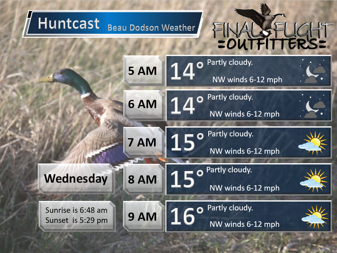
This forecast update covers far southern Illinois, far southeast Missouri, and far western Kentucky. See the coverage map on the right side of the blog.
Remember that weather evolves. Check back frequently for updates, especially during active weather.

Tuesday Night – Snow showers ending. Some decrease in cloud cover. Cold. Wind chills in the single digits. Bitterly cold.
Temperatures: Lows from 10-16 degrees. Could be colder in a few spots.
Winds: Northwest winds at 4-8 mph with gusts to 16 mph.
What is the chance for precipitation? 40% before 9 pm.
Coverage of precipitation? Scattered
My confidence in this part of the forecast verifying is High
Should I be concerned about snow or ice? Early in the evening some snow showers still possible.
Should I cancel my outdoor plans? Not the best evening.
Is severe weather expected? No
What impact is expected? Suspect light snow showers will have ended by Tuesday night. Low wind chill values.
Wednesday – Partly sunny during the morning. Increasing clouds in the afternoon. Light snow developing from the northwest and spreading southeast during the afternoon hours.
Temperatures: Highs will range 24-28 degrees over southern Illinois, western Kentucky, and northwest Tennessee. Poplar Bluff area of southeast Missouri might end up in the upper 20s to around 30 degrees.
Winds: Northwest winds at 5-10 mph. Gusts of 15-20 mph possible.
What is the chance for precipitation? 50%
Coverage of precipitation? Perhaps scattered late in the day.
My confidence in this part of the forecast verifying is High
Should I be concerned about snow or ice? Late in the day there could be some light snow developing.
Should I cancel my outdoor plans? No
Is severe weather expected? No
What impact is expected? Low wind chill values.
Winter Weather Radars
WEATHER RADAR PAGE – Click here —
Wednesday Night – Cloudy. Light snow possible. A band from northwest to southeast.
Temperatures: Lows from 12-16 degrees
Winds: Northeast winds at 5-10 mph
What is the chance for precipitation? 50%-70%
Coverage of precipitation? Scattered. Perhaps a narrow band of light snow from northwest to southeast over the area.
My confidence in this part of the forecast verifying is Medium
Should I be concerned about snow or ice? Yes, some snow possible.
Should I cancel my outdoor plans? Could be some slick spots because of light snow.
Is severe weather expected? No
What impact is expected? Bitterly cold air. Snow possible. Slick roads possible. Light accumulation possible.
Thursday – Some clouds. Morning light snow possible. Then, becoming partly cloudy. Cold.
Temperatures: Highs will range 26-32 degrees. Warmest temperatures over western parts of southeast Missouri. Poplar Bluff might reach 36-38 degrees.
Winds: North and northeast winds at 6-12 mph.
What is the chance for precipitation? 40% early.
Coverage of precipitation? Scattered
My confidence in this part of the forecast verifying is Medium
Should I be concerned about snow or ice? Some morning light snow possible. Narrow band over the area.
Should I cancel my outdoor plans? No, but you may have to deal with some light snow in the morning. Cold temperatures
Is severe weather expected? No
What impact is expected? Some slick spots possible on roadways.
Thursday Night – A few clouds. Cold.
Temperatures: Lows from 16-24 degrees
Winds: Northeast winds at 5-10 mph
What is the chance for precipitation? 0%
Coverage of precipitation? None
My confidence in this part of the forecast verifying is High
Should I be concerned about snow or ice? No
Should I cancel my outdoor plans? No
Is severe weather expected? No
What impact is expected? Cold. Could still be some slick spots.
Friday – Partly to mostly cloudy. A chance for a few snow showers.
Temperatures: Highs will range from 36 to 42 degrees.
Winds: Southwest winds 5-10 mph.
What is the chance for precipitation? 20%
Coverage of precipitation? Perhaps spotty
My confidence in this part of the forecast verifying is Medium
Should I be concerned about snow or ice? Small chance
Should I cancel my outdoor plans? No
Is severe weather expected? No
What impact is expected? Maybe some flurries or snow showers. But, not expecting any impacts from this.
Friday Night – Clearing. Cold.
Temperatures: Lows from 16-24 degrees
Winds: Northeast winds at 5-10 mph
What is the chance for precipitation? 0%
Coverage of precipitation? None
My confidence in this part of the forecast verifying is High
Should I be concerned about snow or ice? No
Should I cancel my outdoor plans? No
Is severe weather expected? No
What impact is expected? Cold. Could still be some slick spots.
Saturday – Mostly sunny. Perhaps some high clouds late in the day.
Temperatures: Highs will range from 26 to 34 degrees.
Winds: North winds at 5-10 mph.
What is the chance for precipitation? 0%
Coverage of precipitation? None
My confidence in this part of the forecast verifying is High
Should I be concerned about snow or ice? No
Should I cancel my outdoor plans? No
Is severe weather expected? No
What impact is expected? None anticipated.
Saturday Night – Becoming cloudy.
Temperatures: Lows from 14 to 18 degrees
Winds: North and northeast winds at 5-10 mph
What is the chance for precipitation? 10%
Coverage of precipitation? None
My confidence in this part of the forecast verifying is High
Should I be concerned about snow or ice? No
Should I cancel my outdoor plans? No
Is severe weather expected? No
What impact is expected? Cold temperatures. Wind chills from 8-14 degrees.
Sunday – Cloudy. A wintry mix possible. Monitor updates.
Temperatures: Highs will range from 28-34 degrees.
Winds: Northeast winds 5-10 mph.
What is the chance for precipitation? 40%-60%
Coverage of precipitation? Scattered
My confidence in this part of the forecast verifying is Low to medium
Should I be concerned about snow or ice? We may have a wintry mix in the region
Should I cancel my outdoor plans? Monitor updates
Is severe weather expected? No
What impact is expected? If a wintry mix develops then slick roads will be an issue. Monitor updates.
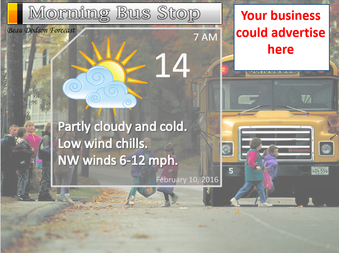
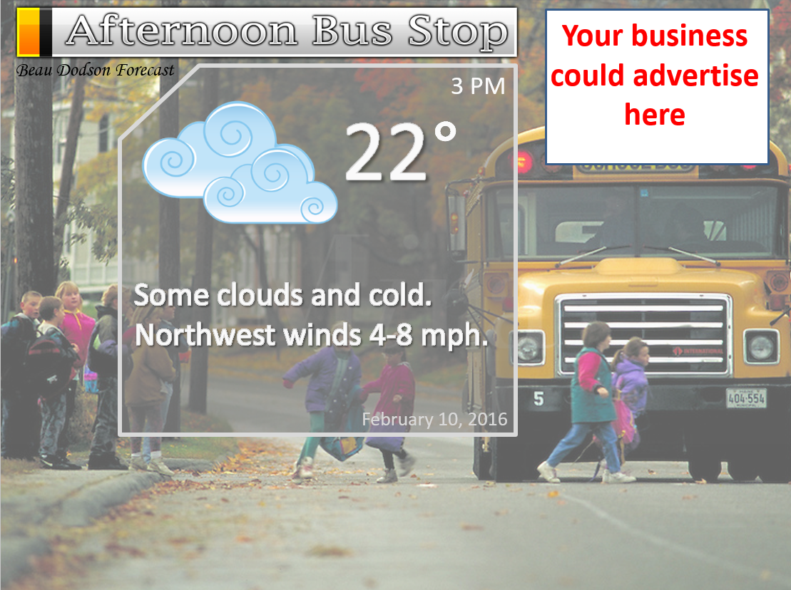
We still have the school bus stop forecast AD spot available 🙂

Don’t forget to check out the Southern Illinois Weather Observatory web-site for weather maps, tower cams, scanner feeds, radars, and much more! Click here

An explanation of what is happening in the atmosphere over the coming days…
Highlights
1. Slick spots on area roads
2. Cold/bitterly cold wind chills
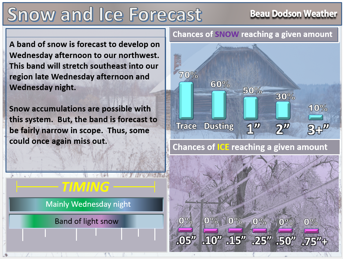
3. Light snow possible Wednesday afternoon and Wednesday night.
4. Light snow on Thursday night/Friday?
5. Bigger snow event on Sunday?
Winter Weather Radars
WEATHER RADAR PAGE – Click here –
A fairly active weather pattern over the coming 7-14 days.
Snow showers produced some accumulation of snow over our region on Monday night and Tuesday. Some picked up no measurable snowfall. Others picked up 1-2″ of snow. Temperatures fell into the 20s on Monday night and this helped roads become slick and hazardous over some of our counties. Not all, but some.
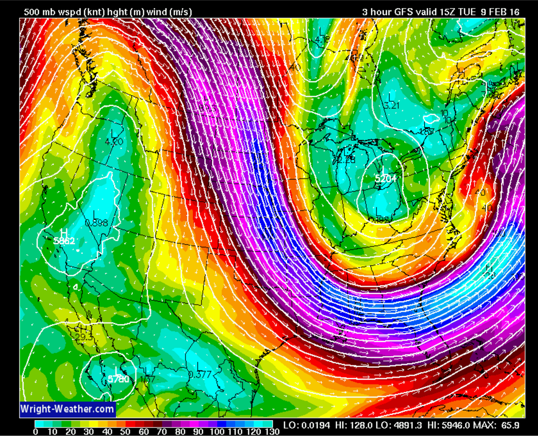
A fast moving jet stream dipping down from Canada into the southern United States will bring another system into the region late Wednesday afternoon into Wednesday night.
Here is the 500 mb wind map. 500 mb = 18,000′ aloft. See how the pink and blue colors are coming out of Canada? They dip into the southern United States. That is a FAST moving jet stream pattern. Systems can dive down out of Canada and quickly push into our region. I will show you one of those systems.
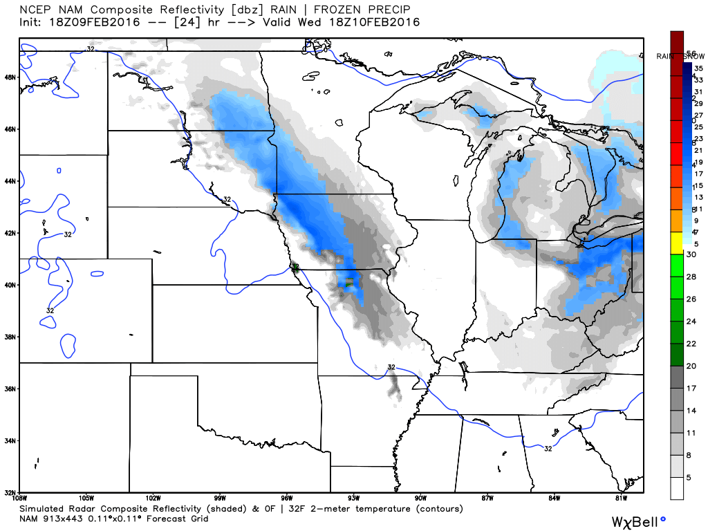
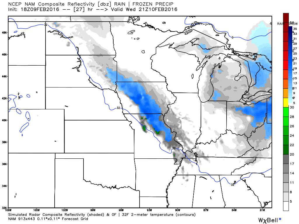
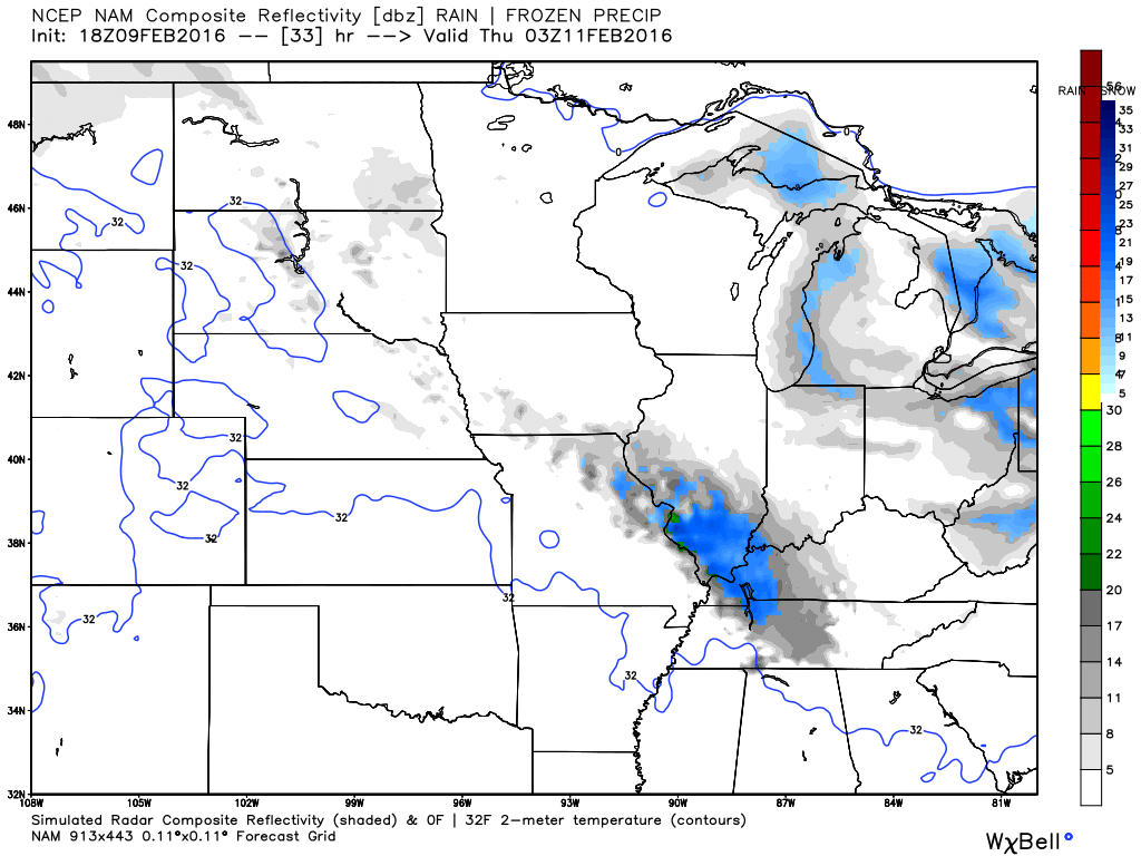
A band of snow is forecast to develop over Iowa and northwest Missouri on Wednesday morning and afternoon. This band of snow will move quickly southeast into our region by afternoon into the evening hours.
Here is the future-cast precipitation maps from the NAM model.
This is for the 10 am to 12 pm time frame on Wednesday morning. Blue is snow. It is moving southeast. Grey is light snow flurries or snow showers.
Here is the 1 pm to 3 pm map. Snow continues to move southeast.
This is the Wednesday evening map. This is around 5 pm to 7 pm.

This is the map for Wednesday night around 9 pm.
This is for Thursday morning around 1 am
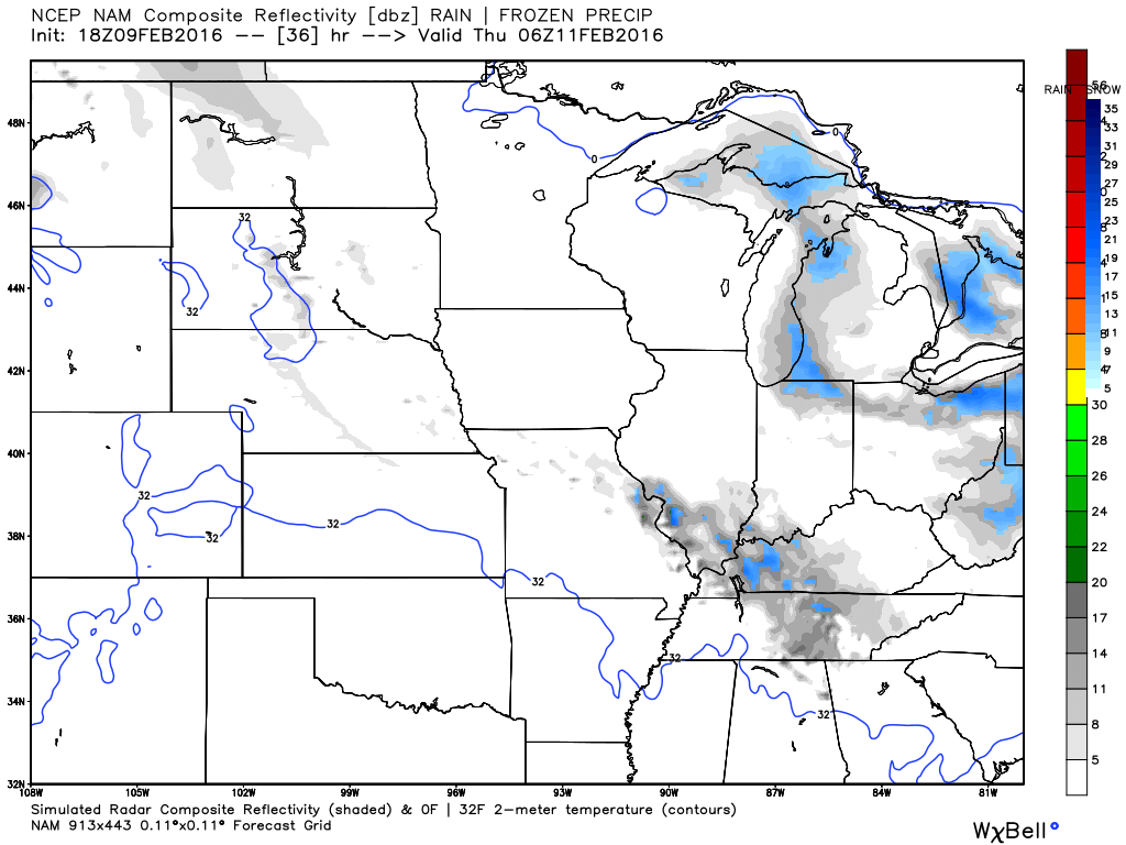
Light snow will be possible Wednesday afternoon over our northwest counties and it should spread southeast through the afternoon and evening hours.
Cold air will mean high snow ratios. Snow ratios of 20:1 will be possible. Perhaps more. That means that 0.10″ of liquid would mean 1″-2″ of snow. Although this is not forecast to be a large snow event, it could still produce slick roadways.
Once again, some locations will likely not measure any snow from this event. But, others could pick up a quick 1-2″ of snow. Right now, assuming the storm tracks as forecast, it appears the best chance for accumulating snow will be over far southeast Missouri, southern Illinois, into western Kentucky. Perhaps northwest Tennessee, as well.
Confidence on this event is medium.
I am watching another weak disturbance on Friday and Friday night. But, I believe odds favor that one coming through with very little in the way of precipitation. I will continue to monitor it.
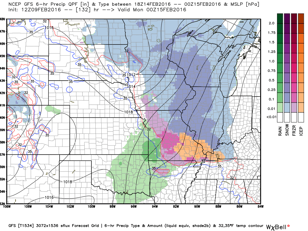
A larger storm system is forecast to bring widespread snow, sleet, and perhaps freezing rain to the region on Sunday and Monday. Perhaps centered on Sunday afternoon and Sunday night. Confidence on that event is medium. Still several days away.
Accumulating snow and ice will be possible on Sunday into Monday morning. Let’s keep an eye on it. Still way too early for numbers.
Here is what the GFS looks like on Sunday evening. Orange would be sleet.
I continue to watch the 18th-22nd time frame. Centered on the 20th. That one looks to be a warm system. But, long way off.

Light snow possible Wednesday night and Thursday morning. Can’t rule out some spotty accumulation. This system will be weakening as it moves through the region.
Another light snow event is possible on Friday. This one looks to track a bit more to the northeast. Any accumulations would be light. IF there is snow. The Friday event does not have a lot of moisture to work with.

Wednesday – Light snow developing during the afternoon hours.
Wednesday night – Light snow possible. Medium confidence.
Thursday – Any morning light snow will come to an end.
Friday – Light snow possible. Low confidence.
Saturday – No snow or ice anticipated.
Sunday – Snow is possible. Medium confidence.

Updated snow chances Wednesday night and Thursday.

Wind chill values will dip into the single digits Tuesday night and Wednesday. Kids will need gloves and mittens.


Several wild cards in this update! We have three snow events to monitor. Wednesday afternoon into Thursday night, Friday, and then Sunday afternoon into Monday morning. The largest of the events is forecast to be on Sunday/Monday. But, light accumulation of snow can’t be ruled out on Wednesday night and Friday.

How much precipitation should we expect over the next few days?
A weak system on Wednesday afternoon and Thursday night could produce a band of light snow over the region. This will be a weakening system. But, can’t rule out light accumulations. The clipper will be weakening as it moves over our region.
A larger system is still forecast for Sunday and Monday. This one could produce quite a bit of precipitation for the region. Mostly snow, it would appear. Monitor updates.

Can we expect severe thunderstorms over the next 24 to 48 hours? Remember that a severe thunderstorm is defined as a thunderstorm that produces 58 mph winds or higher, quarter size hail or larger, and/or a tornado.
The thunderstorm threat level will be a ZERO through Thursday.

Here is the official 6-10 day and 8-14 day temperature and precipitation outlook. Check the date stamp at the top of each image (so you understand the time frame).
The forecast maps below are issued by the Weather Prediction Center (NOAA).


The latest 8-14 day temperature and precipitation outlook. Note the dates are at the top of the image. These maps DO NOT tell you how high or low temperatures or precipitation will be. They simply give you the probability as to whether temperatures or precipitation will be above or below normal.


Here are the current river stage forecasts. You can click your state and then the dot for your location. It will bring up the full forecast and hydrograph.
Click Here For River Stage Forecasts…

Who do you trust for your weather information and who holds them accountable?
I have studied weather in our region since the late 1970’s. I have 37 years of experience in observing our regions weather patterns. My degree is in Broadcast Meteorology from Mississippi State University and an Associate of Science (AS). I am currently working on my Bachelor’s Degree in Geoscience.
My resume includes:
Member of the American Meteorological Society.
NOAA Weather-Ready Nation Ambassador.
Meteorologist for McCracken County Emergency Management. I served from 2005 through 2015.
I own and operate the Southern Illinois Weather Observatory.
Recipient of the Mark Trail Award, WPSD Six Who Make A Difference Award, Kentucky Colonel, and the Caesar J. Fiamma” Award from the American Red Cross.
In 2009 I was presented with the Kentucky Office of Highway Safety Award.
Recognized by the Kentucky House of Representatives for my service to the State of Kentucky leading up to several winter storms and severe weather outbreaks.
I am also President of the Shadow Angel Foundation which serves portions of western Kentucky and southern Illinois.
There is a lot of noise on the internet. A lot of weather maps are posted without explanation. Over time you should learn who to trust for your weather information.
My forecast philosophy is simple and straight forward.
- Communicate in simple terms
- To be as accurate as possible within a reasonable time frame before an event
- Interact with you on Twitter, Facebook, and the blog
- Minimize the “hype” that you might see on television or through other weather sources
- Push you towards utilizing wall-to-wall LOCAL TV coverage during severe weather events
I am a recipient of the Mark Trail Award, WPSD Six Who Make A Difference Award, Kentucky Colonel, and the Caesar J. Fiamma” Award from the American Red Cross. In 2009 I was presented with the Kentucky Office of Highway Safety Award. I was recognized by the Kentucky House of Representatives for my service to the State of Kentucky leading up to several winter storms and severe weather outbreaks.
If you click on the image below you can read the Kentucky House of Representatives Resolution.

Many of my graphics are from www.weatherbell.com – a great resource for weather data, model data, and more


You can sign up for my AWARE email by clicking here I typically send out AWARE emails before severe weather, winter storms, or other active weather situations. I do not email watches or warnings. The emails are a basic “heads up” concerning incoming weather conditions.