We have some great sponsors for the Weather Talk Blog. Please let our sponsors know that you appreciate their support for the Weather Talk Blog.
Milner and Orr Funeral Home and Cremation Services located in Paducah, Kentucky and three other western Kentucky towns – at Milner and Orr they believe in families helping families. You can find Milner and Orr on Facebook, as well.
![]()
.

For all of your families eye care needs. Visit their web-site here. Or, you can also visit their Facebook page.
.

Best at Enabling Body Shop Profitability since 1996. Located In Paducah Kentucky and Evansville Indiana; serving all customers in between. They provide Customer Service, along with all the tools necessary for body shops to remain educated and competitive. Click the logo above for their main web-site. You can find McClintock Preferred Finishes on Facebook, as well
.

Duck/goose decoys? Game calls? Optics? We have you covered! Click the logo above or visit Final Flight on Facebook, as well.
.
I have launched the new weather texting service! I could use your help. Be sure and sign up and fully support all of the weather data you see each day.
This is a monthly subscription service. Supporting this helps support everything else. The cost is $3 a month for one phone, $5 a month for three phones, and $10 a month for seven phones.
For more information visit BeauDodsonWeather.com
Or directly sign up at Weathertalk.com


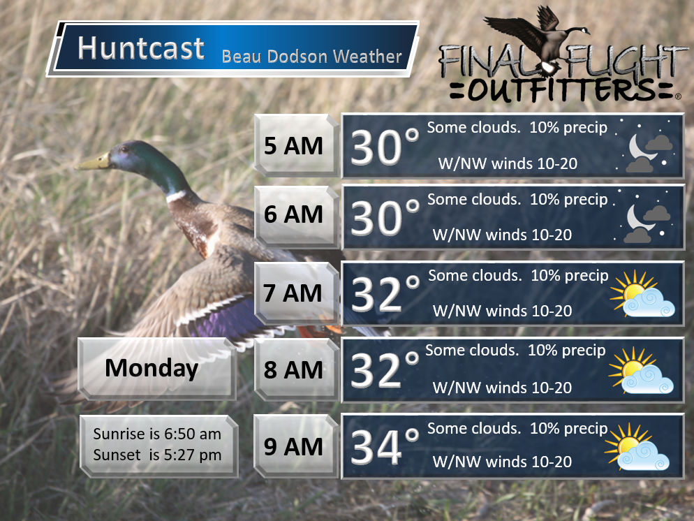
This forecast update covers far southern Illinois, far southeast Missouri, and far western Kentucky. See the coverage map on the right side of the blog.
Remember that weather evolves. Check back frequently for updates, especially during active weather.

Sunday Night – Increasing clouds. Chance for patchy light rain or rain/snow mix.
Temperatures: Lows from 32 to 36 degrees
Winds: West/northwest winds at 8-16 mph
What is the chance for precipitation? 30%
Coverage of precipitation? Isolated to scattered
My confidence in this part of the forecast verifying is High
Should I be concerned about snow or ice? Not likely
Should I cancel my outdoor plans? No
Is severe weather expected? No
What impact is expected? Maybe some wet roadways.
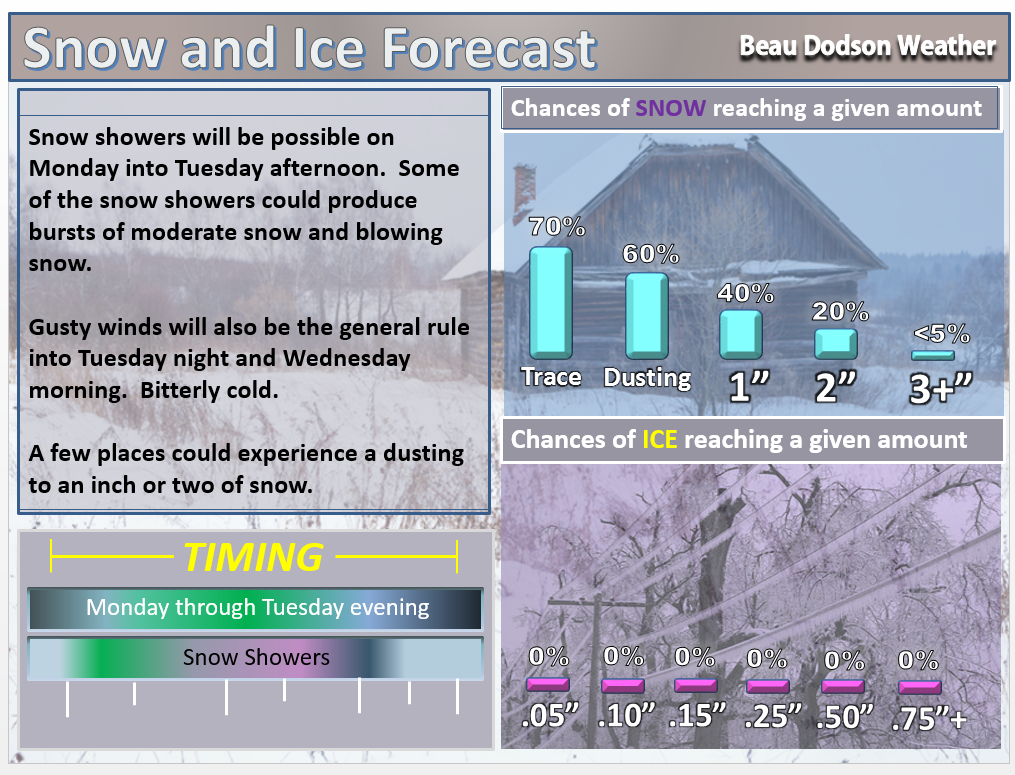
Possibly a dusting to an inch or so of snow on Monday/Tuesday. Some areas will only see snowflakes in the air. But, a few locations might end up with a little bit of accumulation.
Winter Weather Radars
WEATHER RADAR PAGE – Click here —
Monday – Windy. Partly to mostly cloudy. Snow showers possible. Falling temperatures during the day.
Temperatures: Highs will range 34 to 38 degrees. Then falling temperatures during the afternoon.
Winds: Northwest winds at 10-20 mph and gusty.
What is the chance for precipitation? 40%-60%
Coverage of precipitation? Scattered
My confidence in this part of the forecast verifying is High
Should I be concerned about snow or ice? Some light snow possible.
Should I cancel my outdoor plans? No
Is severe weather expected? No
What impact is expected? Snow showers possible. Wet roadways possible. If temperatures fall low enough during the afternoon hours then we could see a few slick spots on bridges/overpasses. Believe most areas will not experience any significant issues.
Monday Night – Cloudy and windy. Snow showers possible. Wind chills in the single digits to lower teens.
Temperatures: Lows from 18 to 24 degrees.
Winds: Northwest winds at 8-16 mph with gusts above 25 mph
What is the chance for precipitation? 40%-60%
Coverage of precipitation? Perhaps isolated
My confidence in this part of the forecast verifying is High
Should I be concerned about snow or ice? Some snow showers possible. Light accumulation can’t be ruled out.
Should I cancel my outdoor plans? Have alternative plans. Bitterly cold air, low wind chills, and maybe some snow showers will not make for the best outdoor weather conditions.
Is severe weather expected? No
What impact is expected? Maybe some snow showers. Light accumulation possible. Low wind chill values.
Tuesday – Cloudy and cold. Light snow showers possible. Wind chills in the single digits to lower teens.
Temperatures: Highs will range 24 to 28 degrees
Winds: Northwest winds at 10-20 mph. Gusty winds, at times.
What is the chance for precipitation? 40%
Coverage of precipitation? Scattered
My confidence in this part of the forecast verifying is Medium
Should I be concerned about snow or ice? Monitor updates
Should I cancel my outdoor plans? Not the best outdoor conditions.
Is severe weather expected? No
What impact is expected? Perhaps some snow showers. Light accumulation possible. Low wind chill values.
Tuesday Night – Some decrease in cloud cover. Cold. Wind chills in the single digits. Bitterly cold.
Temperatures: Lows from 10-16 degrees
Winds: Northwest winds at 4-8 mph with gusts to 20 mph.
What is the chance for precipitation? 10%
Coverage of precipitation? Isolated
My confidence in this part of the forecast verifying is High
Should I be concerned about snow or ice? Not likely
Should I cancel my outdoor plans? No
Is severe weather expected? No
What impact is expected? Suspect light snow showers will have ended by Tuesday night. Low wind chill values.
Wednesday – Partly to mostly sunny. Cold.
Temperatures: Highs will range 24-28 degrees
Winds: Northwest winds at 5-10 mph. Gusts of 15-20 mph possible.
What is the chance for precipitation? 0%
Coverage of precipitation? None
My confidence in this part of the forecast verifying is High
Should I be concerned about snow or ice? No
Should I cancel my outdoor plans? No
Is severe weather expected? No
What impact is expected? Low wind chill values.
Wednesday Night – A few clouds and cold.
Temperatures: Lows from 10-16 degrees
Winds: Northwest winds at 5-10 mph
What is the chance for precipitation? 10%
Coverage of precipitation? None
My confidence in this part of the forecast verifying is High
Should I be concerned about snow or ice? No
Should I cancel my outdoor plans? No
Is severe weather expected? No
What impact is expected? Bitterly cold air.
Thursday – Some clouds. Small chance for flurries. Cold.
Temperatures: Highs will range 26-32 degrees
Winds: North winds at 5 mph.
What is the chance for precipitation? 10%
Coverage of precipitation? None
My confidence in this part of the forecast verifying is High
Should I be concerned about snow or ice? No
Should I cancel my outdoor plans? No
Is severe weather expected? No
What impact is expected? None
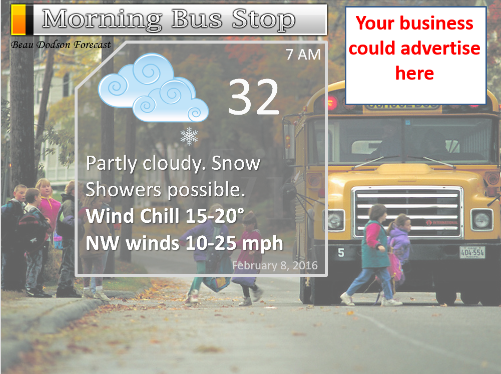
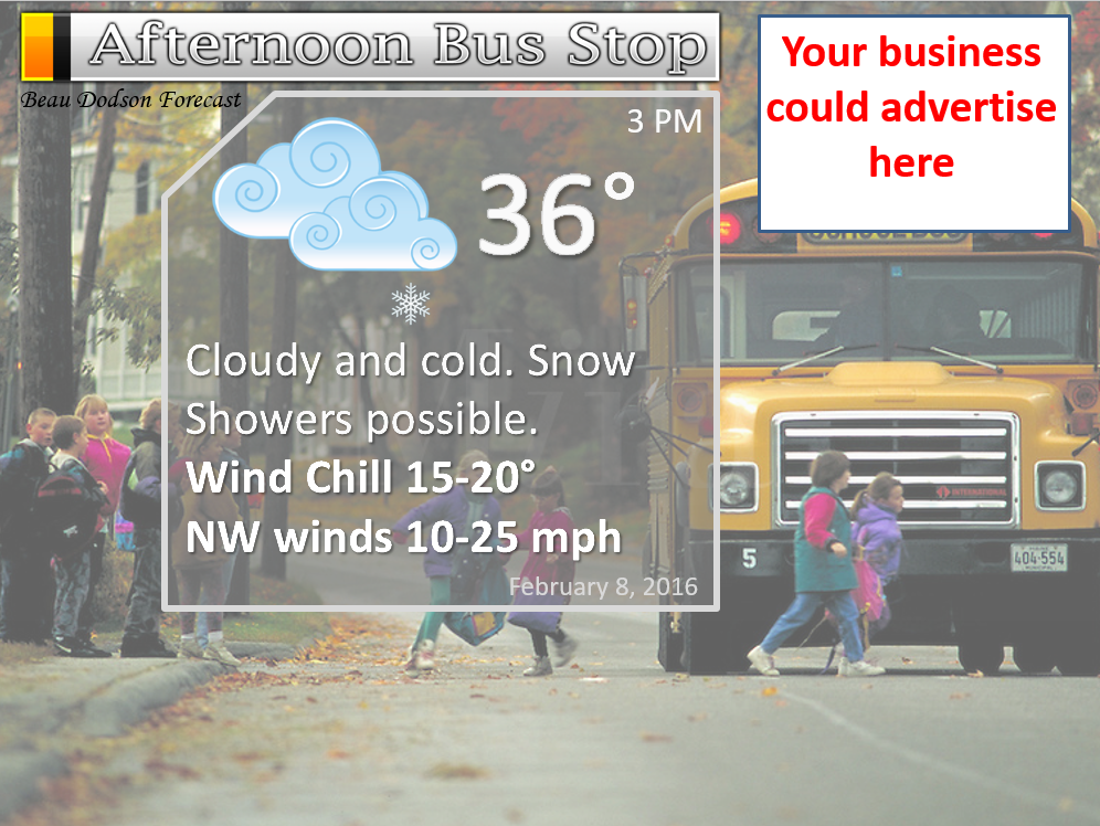
We still have the school bus stop forecast AD spot available 🙂

Don’t forget to check out the Southern Illinois Weather Observatory web-site for weather maps, tower cams, scanner feeds, radars, and much more! Click here

An explanation of what is happening in the atmosphere over the coming days…
Highlights
1. Winter returns
2. Cold temperatures, low wind chills, and snow showers
3. Some small snow accumulation can’t be ruled out
4. Gusty winds Monday and Tuesday
5. Watching February 14th-18th for another precipitation maker
Winter Weather Radars
WEATHER RADAR PAGE – Click here —
Did you enjoy today. This is the best image I could find to sum up today compared to the upcoming week.

This next image sums up the rest of the week

Let’s dig right into it
Two cold fronts will sweep through the region on Sunday night and Monday morning. The first front will deliver some clouds and perhaps light rain showers on Sunday evening.
The second front will deliver cold temperatures.
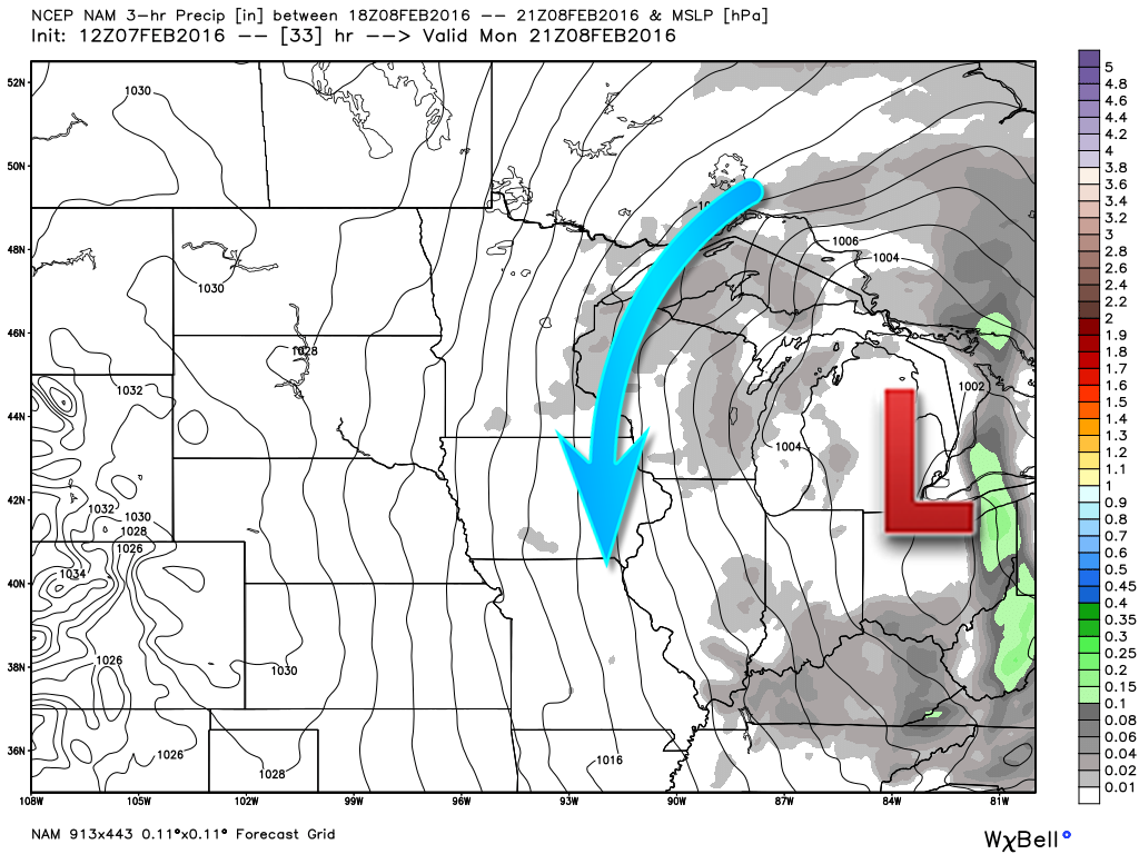
A large low pressure center will spiral over the Great Lakes on Monday into at least Wednesday. The area of low pressure will be spinning counter-clockwise. We will be on the west side of this large upper level low. That means cold temperatures, windy conditions, and some snow showers.
Here is the low on the surface map. This image is from weatherbell.com
Winds will gust from 15-30 mph on Monday into Tuesday. Gusts above 30 mph will likely occur. This, combined with cold temperatures, will produce wind chills into the single digits from time to time.
The reason we will have gusty winds will be the tight isobars around the area of low pressure over the Great Lakes. What are isobars? Equal lines of pressure! The tighter the isobars are packed together the gustier your winds will be.
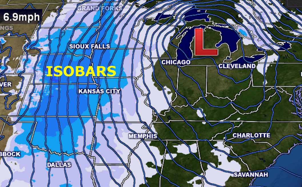
Here is the wind map for Monday afternoon. Winds of 20-30 mph are a good bet.
Actual air temperatures will remain in the 30s on Monday and likely only 20s on Tuesday and Wednesday. Overnight lows will dip into the upper teens and lower 20s on Tuesday morning and upper single digits to lower teens on Wednesday morning. Brrrr will be the word.
You really didn’t think winter was over, did you?
Snow showers will accompany the cold temperatures. Snow showers could occasionally produce moderate bursts of snow. A dusting to 1-2″ of snow can’t be ruled out. These snow showers will appear as bands on radar. Thus, it will be very difficult to predict which counties might end up with some light accumulation totals.
The snow will be dry in nature. Thus, blowing snow could develop where accumulation does occur.
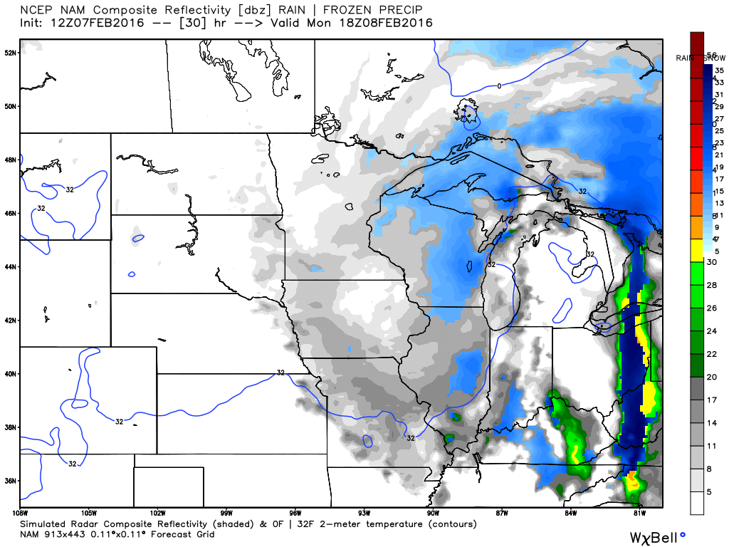
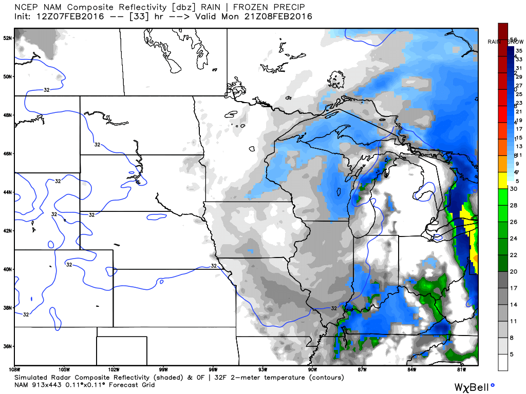
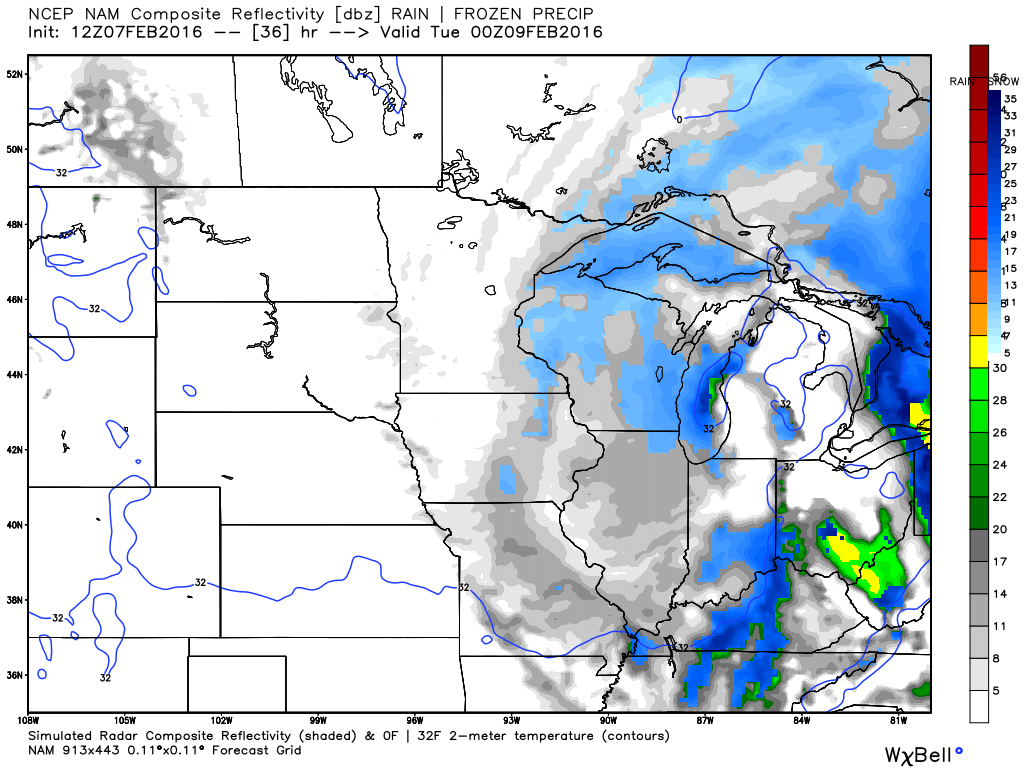
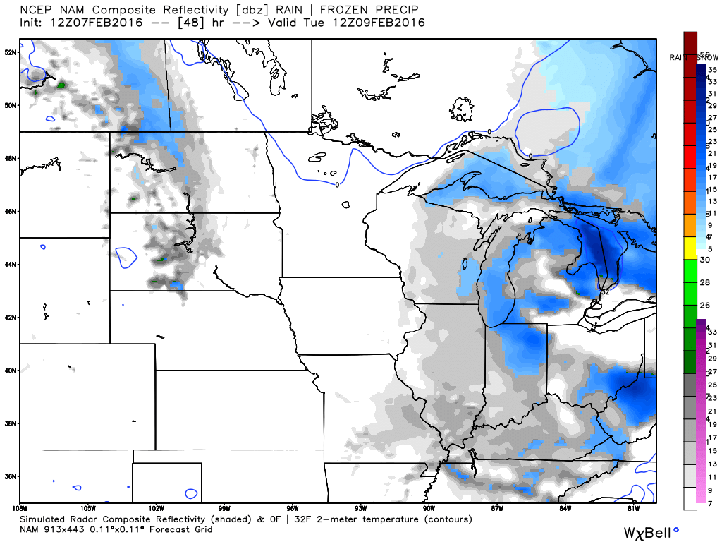
Let’s take a look at some future-cast radar images from weatherbell.com
This is what radar MIGHT look like on Monday/Tuesday. It won’t be exact. But, this gives you a general idea. Scattered snow showers Monday and Tuesday. Grey colors represent the lightest snow showers/flurries. The blue would be snow showers.
This first image is for 11 am – 12 pm on Monday morning.
This next image is for Monday afternoon 2 pm to 4 pm
This next image is for Monday evening. Again, blue represents snow showers. Ignore the green colors. Rain won’t be an issue with colder air moving into the region.
This last image is for Tuesday morning.
Models really won’t handle this type of precipitation set-up very well.
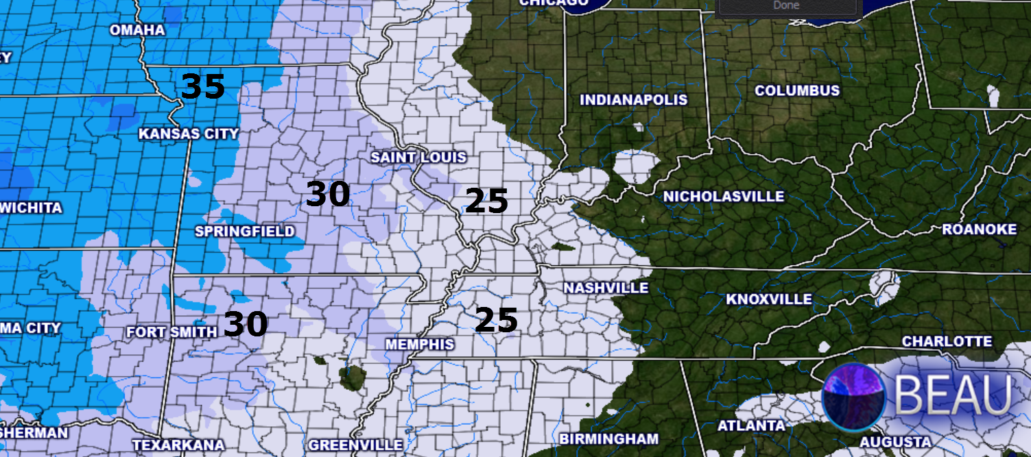
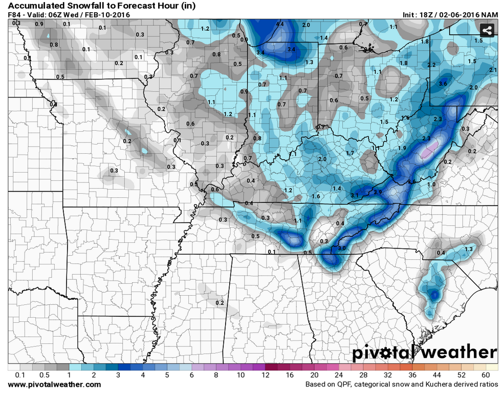
I wanted to show you the NAM model. This is a map showing what the NAM guidance believes will occur as far as snowfall totals. You can see the bands on this map. This map won’t be exact. And, some places will likely not receive any snow accumulation.
But, a few spots might pick up a solid dusting to 1-2″. Lower confidence on the higher totals. Again, some won’t pick up any snow accumulation.
Winter isn’t over.

Snow showers possible Monday into Tuesday evening. No accumulation to perhaps 1-2″ in spots.

Sunday night – Light rain or rain/snow showers possible.
Monday – Snow showers possible
Tuesday – Snow showers possible
Wednesday – No snow or ice anticipated.
Thursday – No snow or ice anticipated.
Friday – No snow or ice anticipated.

Lowered temperatures a bit. Beefed up wording on snow accumulation potential.

Bitterly cold air combined with strong winds will cause wind chills to dip into the single digits on Monday night into Wednesday. Frost bite is always a concern with conditions such as the above.
Snow showers on Monday and Tuesday. A few spots could experience accumulating snow. Blowing snow, as well. Snow accumulations of none to perhaps 1-2″ over the area.


The wild card in the forecast will be snow accumulations. Could someone pick up 1-2″ from this event? It is possible. But, odds favor most areas receiving very little in the way of accumulation.

How much precipitation should we expect over the next few days?
Rain and snow showers Sunday night into Tuesday could drop a trace to 0.10″ of precipitation. That is melted totals.

Can we expect severe thunderstorms over the next 24 to 48 hours? Remember that a severe thunderstorm is defined as a thunderstorm that produces 58 mph winds or higher, quarter size hail or larger, and/or a tornado.
The thunderstorm threat level will be a ZERO through Thursday.

Here is the official 6-10 day and 8-14 day temperature and precipitation outlook. Check the date stamp at the top of each image (so you understand the time frame).
The forecast maps below are issued by the Weather Prediction Center (NOAA).


The latest 8-14 day temperature and precipitation outlook. Note the dates are at the top of the image. These maps DO NOT tell you how high or low temperatures or precipitation will be. They simply give you the probability as to whether temperatures or precipitation will be above or below normal.


Here are the current river stage forecasts. You can click your state and then the dot for your location. It will bring up the full forecast and hydrograph.
Click Here For River Stage Forecasts…

Who do you trust for your weather information and who holds them accountable?
I have studied weather in our region since the late 1970’s. I have 37 years of experience in observing our regions weather patterns. My degree is in Broadcast Meteorology from Mississippi State University and an Associate of Science (AS). I am currently working on my Bachelor’s Degree in Geoscience.
My resume includes:
Member of the American Meteorological Society.
NOAA Weather-Ready Nation Ambassador.
Meteorologist for McCracken County Emergency Management. I served from 2005 through 2015.
I own and operate the Southern Illinois Weather Observatory.
Recipient of the Mark Trail Award, WPSD Six Who Make A Difference Award, Kentucky Colonel, and the Caesar J. Fiamma” Award from the American Red Cross.
In 2009 I was presented with the Kentucky Office of Highway Safety Award.
Recognized by the Kentucky House of Representatives for my service to the State of Kentucky leading up to several winter storms and severe weather outbreaks.
I am also President of the Shadow Angel Foundation which serves portions of western Kentucky and southern Illinois.
There is a lot of noise on the internet. A lot of weather maps are posted without explanation. Over time you should learn who to trust for your weather information.
My forecast philosophy is simple and straight forward.
- Communicate in simple terms
- To be as accurate as possible within a reasonable time frame before an event
- Interact with you on Twitter, Facebook, and the blog
- Minimize the “hype” that you might see on television or through other weather sources
- Push you towards utilizing wall-to-wall LOCAL TV coverage during severe weather events
I am a recipient of the Mark Trail Award, WPSD Six Who Make A Difference Award, Kentucky Colonel, and the Caesar J. Fiamma” Award from the American Red Cross. In 2009 I was presented with the Kentucky Office of Highway Safety Award. I was recognized by the Kentucky House of Representatives for my service to the State of Kentucky leading up to several winter storms and severe weather outbreaks.
If you click on the image below you can read the Kentucky House of Representatives Resolution.

Many of my graphics are from www.weatherbell.com – a great resource for weather data, model data, and more


You can sign up for my AWARE email by clicking here I typically send out AWARE emails before severe weather, winter storms, or other active weather situations. I do not email watches or warnings. The emails are a basic “heads up” concerning incoming weather conditions.