We have our first sponsor for the blog. Milner and Orr Funeral Home and Cremation Services located in Paducah, Kentucky and three other western Kentucky towns – at Milner and Orr they believe in families helping families.
![]()

This forecast update covers far southern Illinois, far southeast Missouri, and far western Kentucky. See the coverage map on the right side of the blog.
Remember that weather evolves. Check back frequently for updates, especially during active weather.
Tuesday – Partly cloudy. Not quite as cold as Monday. Highs will be mainly in the 40’s. South/southwest winds at 10-15 mph. My confidence in this part of the forecast verifying is high
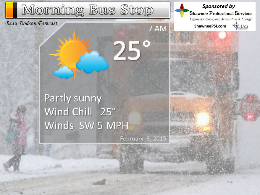
Morning School Bus Stop Weather – Quite a bit of sun. Cool. Morning temps in the middle to upper 20’s. Light winds. Chances of schools being delayed because of the weather 0%
—————————————————————————————-
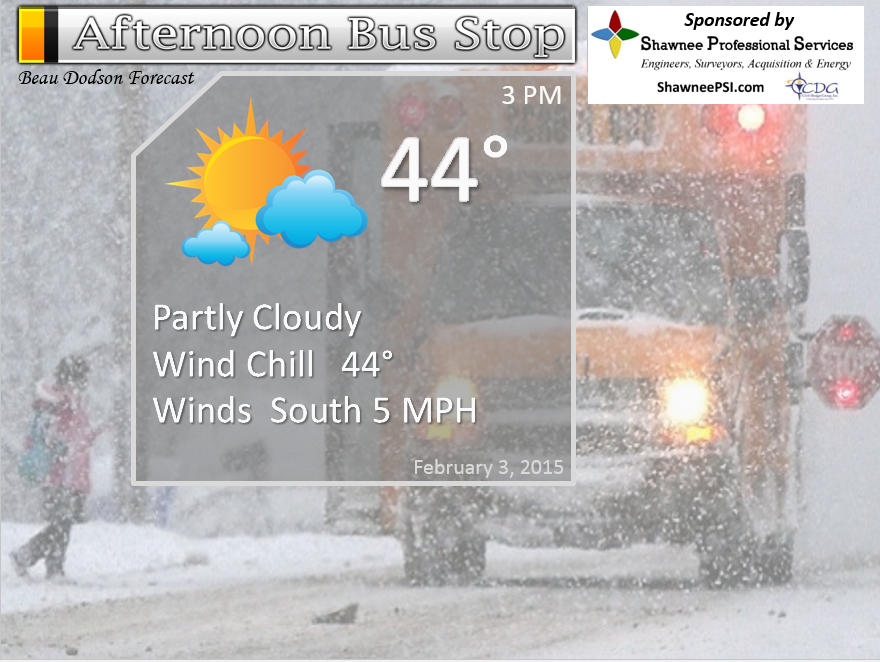
Afternoon School Bus Stop Weather – Partly cloudy. Temperatures will be in the 40’s. Southwest winds at 10 mph.
Tuesday night – Some evening clouds then mostly clear and cool. Southwest winds at 10 mph. My confidence in this part of the forecast verifying is high
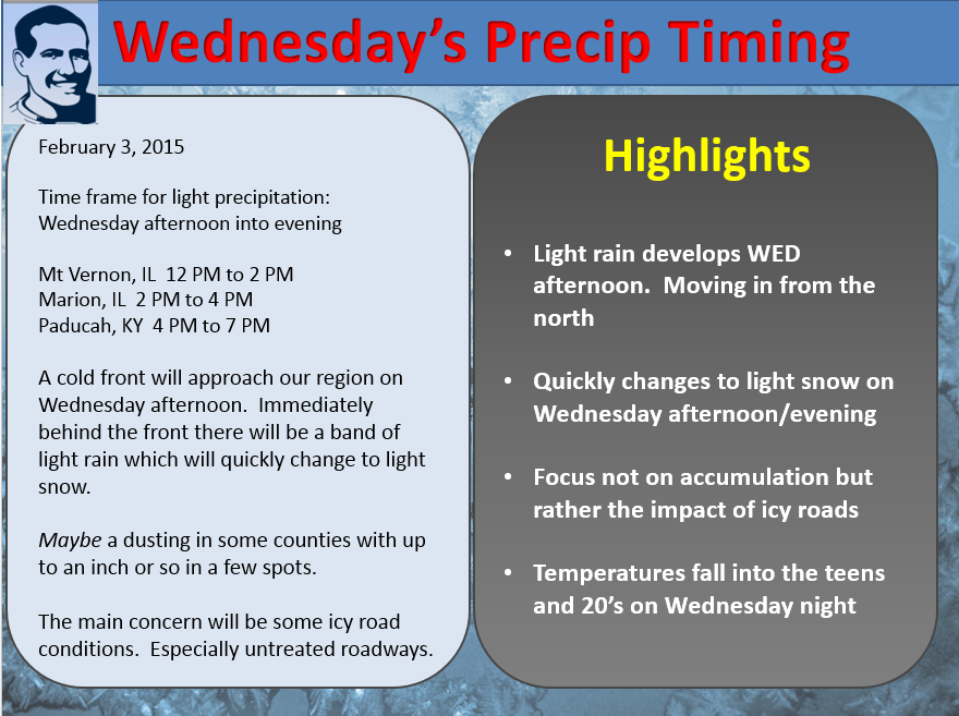
Wednesday – Becoming cloudy during the late morning or afternoon hours. A chance for light rain and snow during the afternoon. Precipitation will be moving in from the north. It will begin first over our northern counties and then slide southward. Temperatures falling during the afternoon hours. Highs early in the day in the 40’s then falling into the 30’s over northern counties of southern Illinois be evening. Southwest winds at 10 mph becoming northwest late in the day at 10-25 mph. My confidence in this part of the forecast verifying is medium
Wednesday night – Cloudy with some light snow. Roads may become icy in spots – especially untreated roadways. Colder. Windier. Lows in the teens over most of the area. Some data indicates upper single digits for the northern parts of southern Illinois. Perhaps upper teens and lower 20’s over west Kentucky. Sharp temperature gradient over the area from north to south. Northwest winds at 10-25 mph. Gusty. My confidence in this part of the forecast verifying is medium
Thursday – Bitterly cold. Some clouds early then mostly sunny and colder. Morning roadways may have some ice on them. Highs in the upper teens and lower 20’s. Northerly winds at 10-20 mph early in the day becoming northerly at 10 mph late. My confidence in this part of the forecast verifying is high

The School Bus Stop Forecast is brought to your by Shawnee Professional Services. For more information click here
Current Temperatures Around The Local Area


An explanation of what is happening in the atmosphere over the coming days…
HIGHLIGHTS…
1. Calm today
2. Precipitation arrives on Wednesday afternoon and night – moving in from the north
3. It will be light rain changing to light snow
4. Rapidly falling temperatures late on Wednesday afternoon and night
5. Some ice may form on roadways because of the fast falling temperatures – this would be Wednesday night/Thursday morning
6. Warmer by the weekend
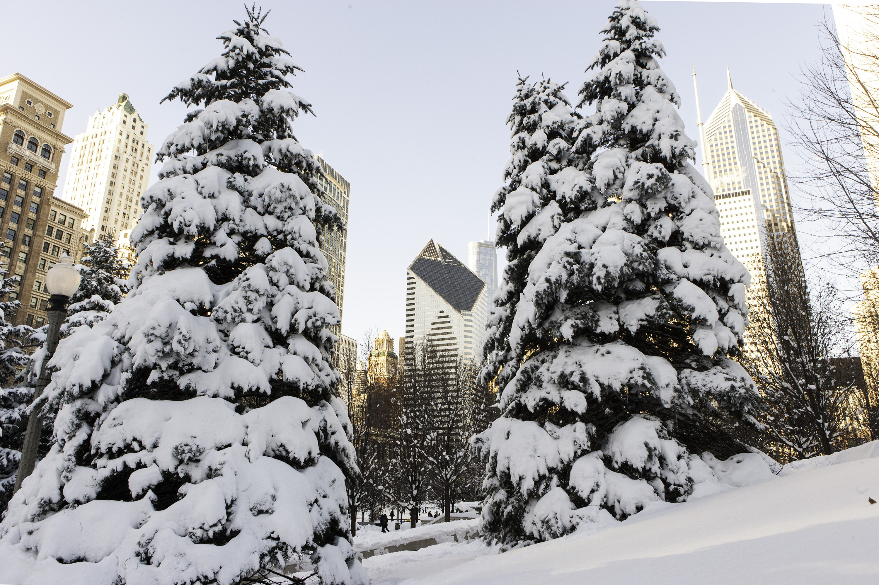
Welcome to Tuesday! I guess everyone survived the flurries on Monday? Chicago ended up with 20 inches of fresh snow. The 5th largest snowstorm in that cities history. Falling behind the 1979 storm by less than an inch. Quite the opposite from the southern end of the state. Many are wondering if we will ever see snow this winter over our local counties. I know snow lovers are just about ready to give up. BRING ME SPRING – is what I am hearing.
Well, winter isn’t finished yet. Let’s just hope March does not end up damp and cold (adding insult to injury for winter fans).
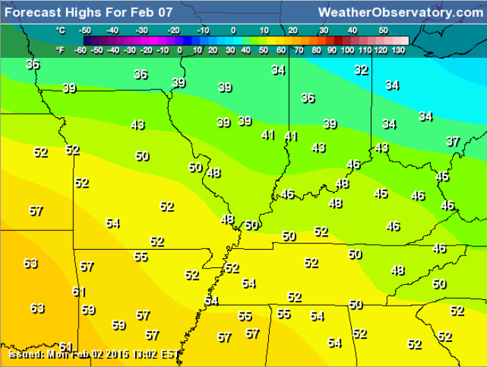
Today will bring calm weather across our region with temperatures rebounding into the 40’s! Not too bad for early February.
Here is the forecast weather map for Tuesday morning
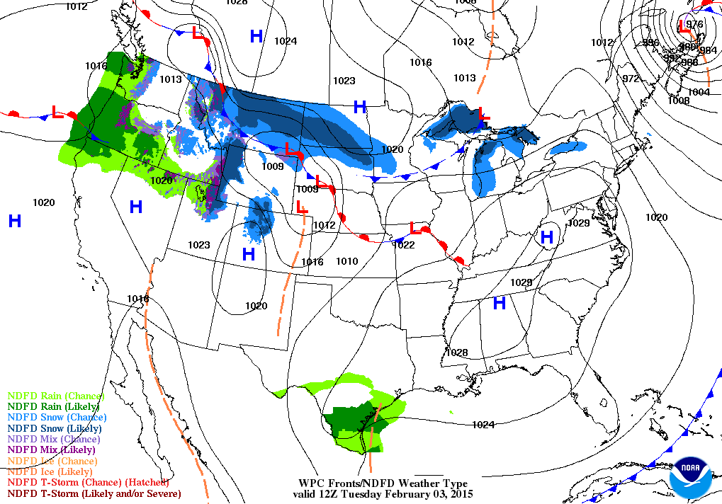
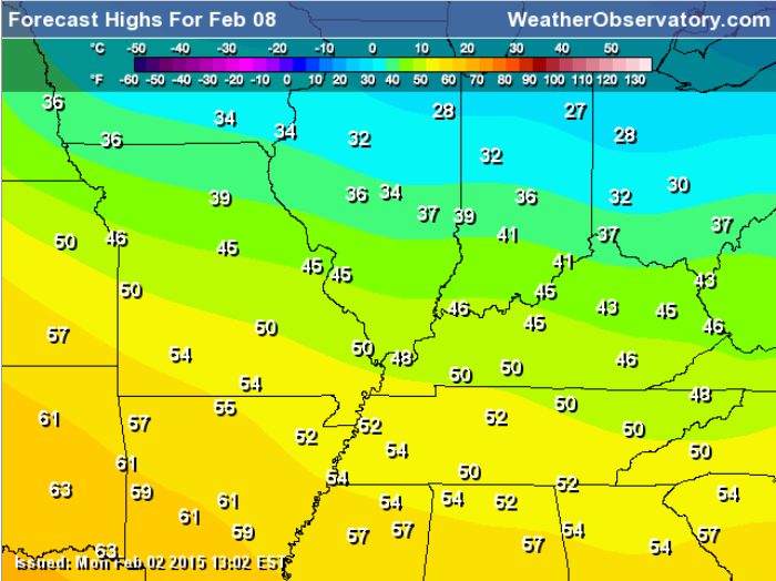
and the forecast map for this evening (Tuesday evening)
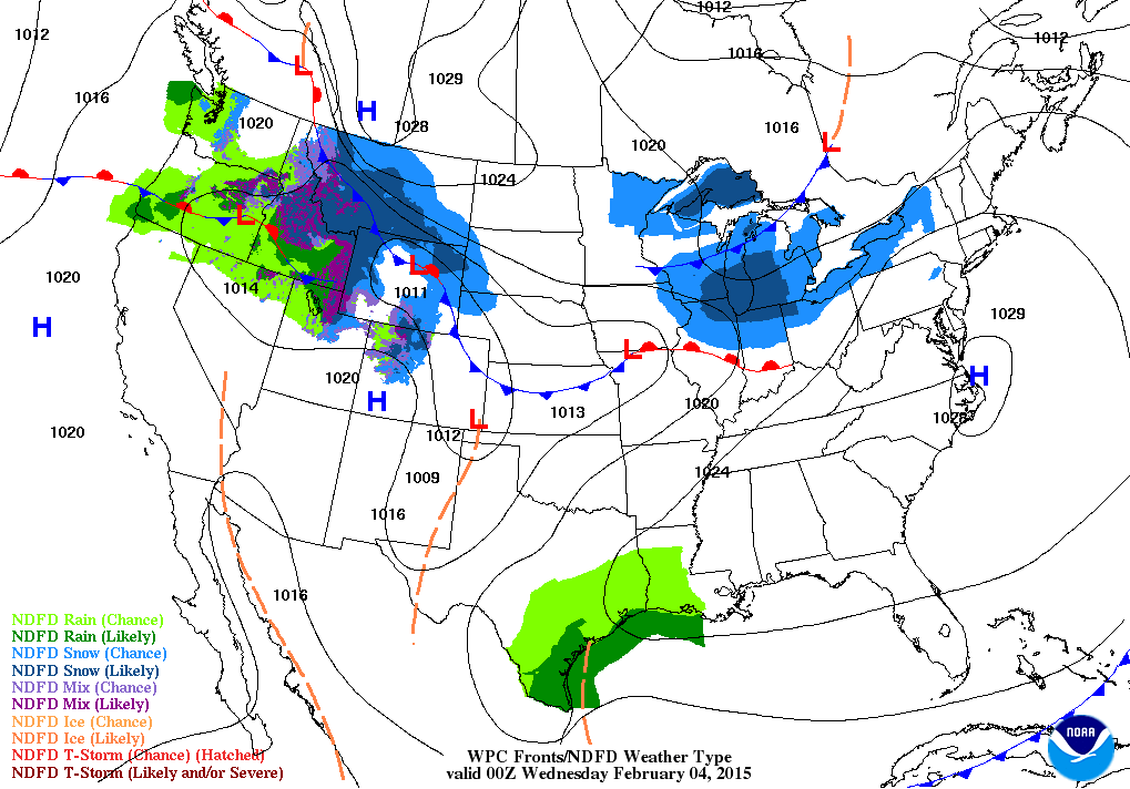
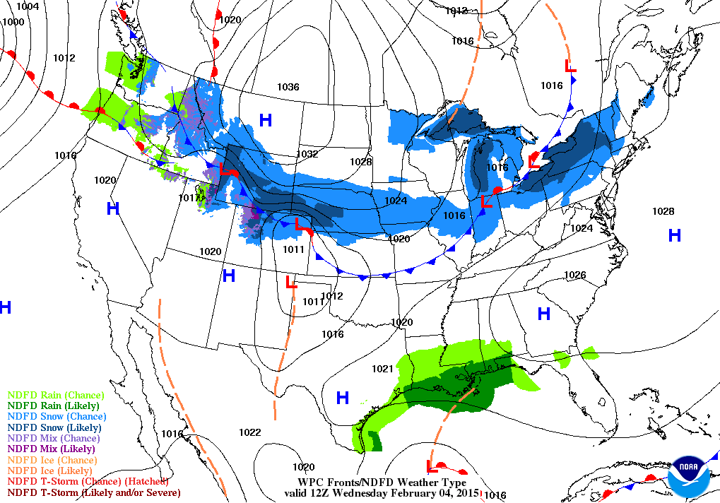
A cold front arrives on Wednesday and Wednesday night. This front will usher in another round of below normal temperatures for Thursday and Friday.
Right along and behind the front we are going to see a period of light rain changing to light snow. My biggest concern with this system is that the rain will fall right before temperatures fall into the 20’s. If a little light snow falls on top of the wet roads then we might see some slick/icy road conditions.
Here is the weather map for Wednesday evening – you can see the front approaching. Most of the precipitation will be right along and behind the front.
Snowfall totals are forecast to be light with this system. The lack of moisture means that precipitation amounts will be less than 0.10″ melted. If that were snow then it might mean a decent dusting or an inch for some counties. I am hoping to have a better handle on this subject by tonight’s update. Bottom line – this won’t be a major winter storm. Perhaps a little light snow by late Wednesday and Wednesday night.
The focus of this event is NOT on snowfall totals. The focus is on the potential for ice to form because it rained on roadways and then a little light snow falls on top of the wet roads. Temperatures then fall into the teens and 20’s – that means icy roads. At least in spots. Keep this in mind.
How it will play out…
Wednesday afternoon you will pull up weather radar. You will see a band of precipitation across central Missouri into central Illinois. This band of precipitation will be moving southward. Not a very wide band of precipitation. Perhaps a few counties wide.
By late Wednesday afternoon and evening the band of precipitation will be moving through southern Illinois and southeast Missouri. You will see it on radar drifting southward.
At the same time you see the precipitation moving into the area you will see temperatures falling from the 40’s into the 30’s and then into the 20’s. By Thursday morning the thermometer will be in the teens and lower 20’s.
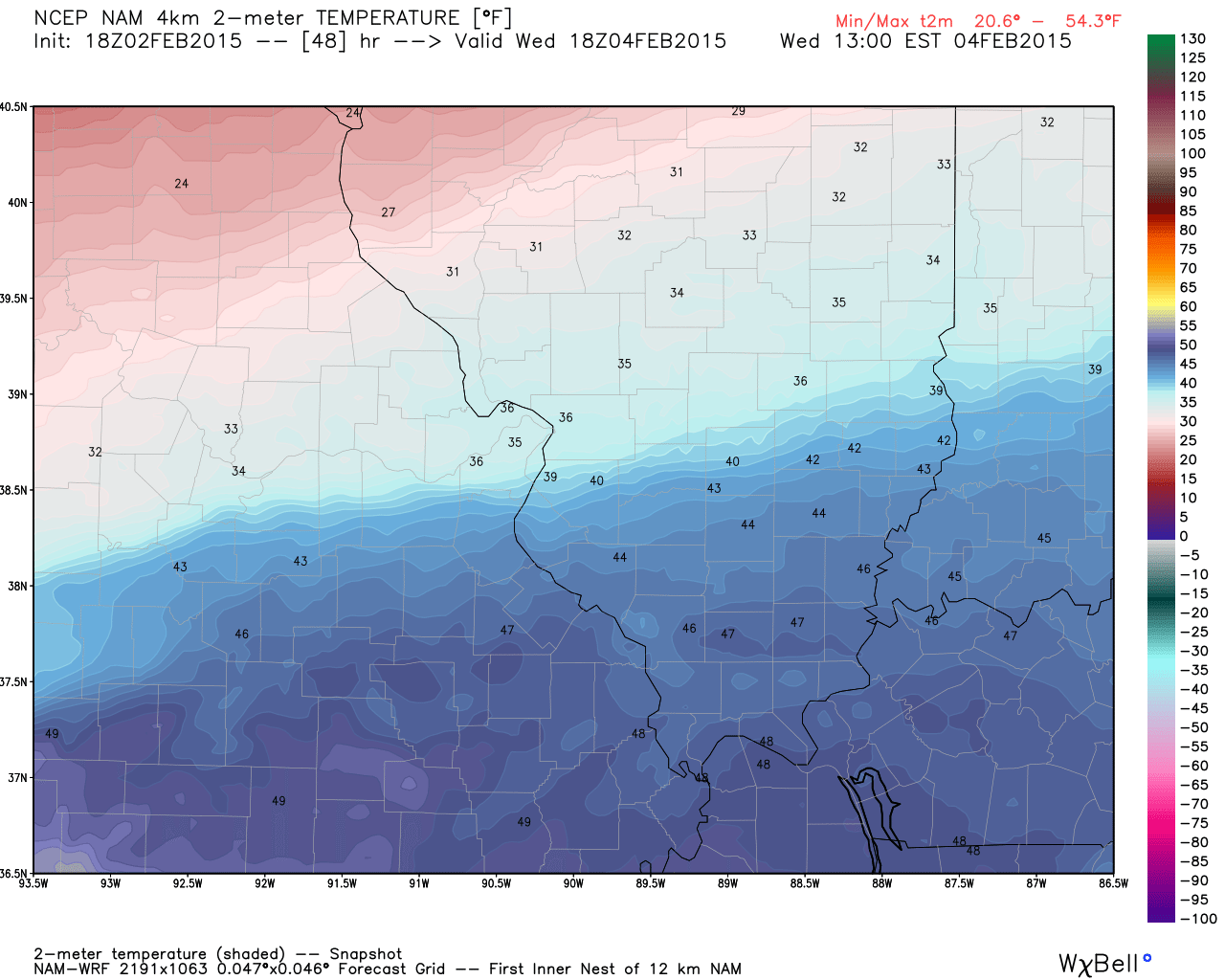
Here is the high resolution NAM model – temperatures on Wednesday. Track the cold! Images are from www.weatherbell.com
At 12 PM on Wednesday – you can see the cold air advancing southward. Click image for larger view of numbers.
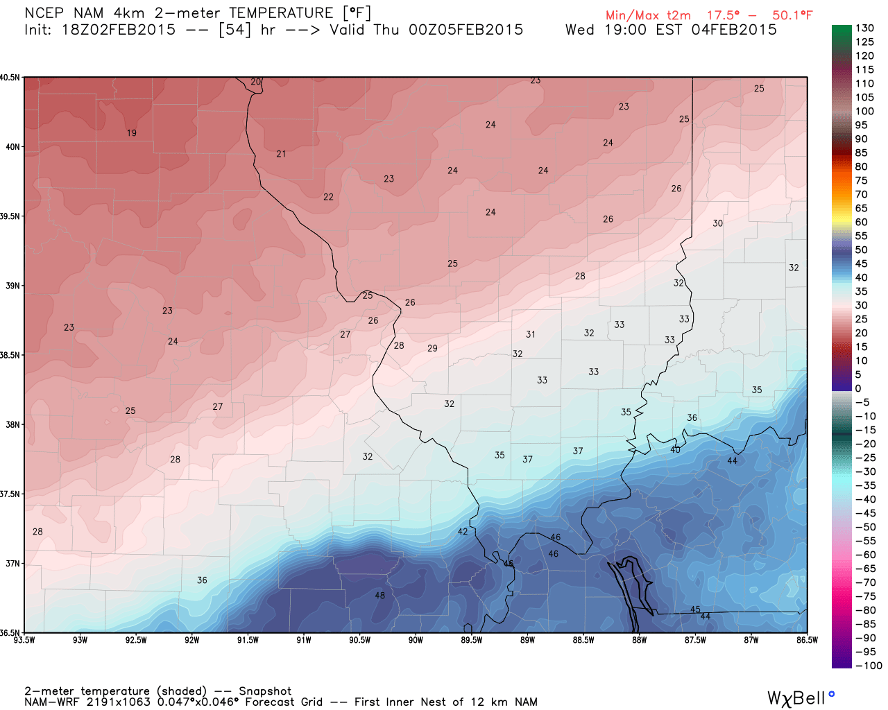
By 5 pm the cold air has settled into much of southern Illinois.
By 11 pm on Wednesday night
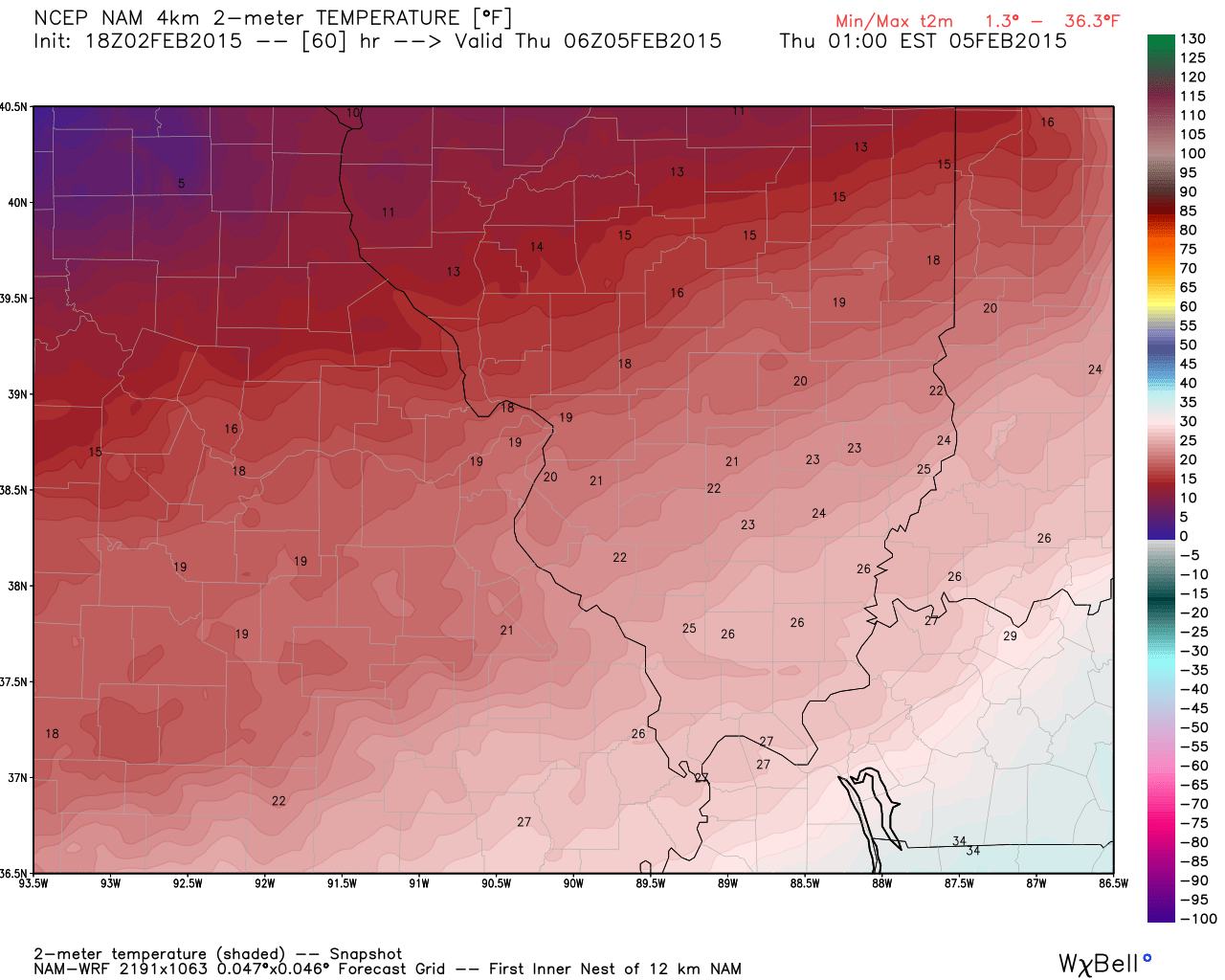
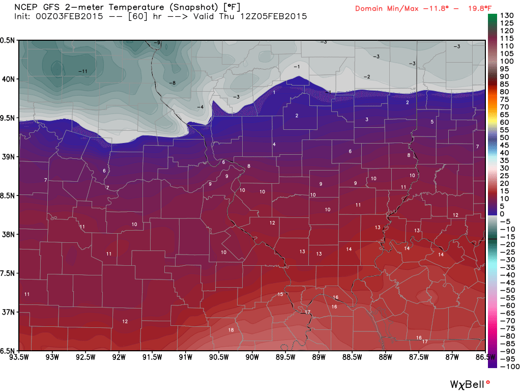
By Thursday morning we will have bitterly cold air over the region. Single digits over far northern counties? Appears possible
Milder temperatures are expected by the weekend. Might we hit 50 by the weekend? Possibly. At least upper 40’s are a good bet. Who is counting down to meteorological spring? It begins on March 1st.
Remember all those crazy forecasts for January? I saw one Kentucky meteorologist calling for the most extreme January in recent memory. Remember everyone talking about the almanacs? Predictions of extreme snow totals…so on and so on. Yes, well 🙂 – how did that turn out? Not so much.
I always remind people that long range forecasts rarely verify. When a meteorologist tells you that an upcoming month is going to be extreme and record breaking…take it with a grain of salt. They are usually trying to get you to click on some web-site (or something similar).
Forecasters, during the winter months, do well to forecast what is going to happen over the coming 2 or 3 day period – let alone the next month.
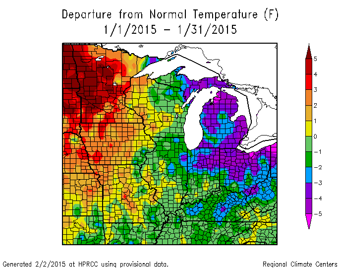
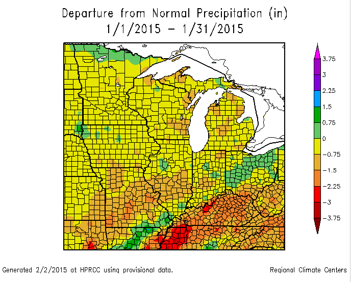
Speaking of January – let’s take a look at temperature and precipitation anomalies.
Temperatures averaged below normal – the beginning of the month is when most of the cold air invaded our region. After that…eh not so much.
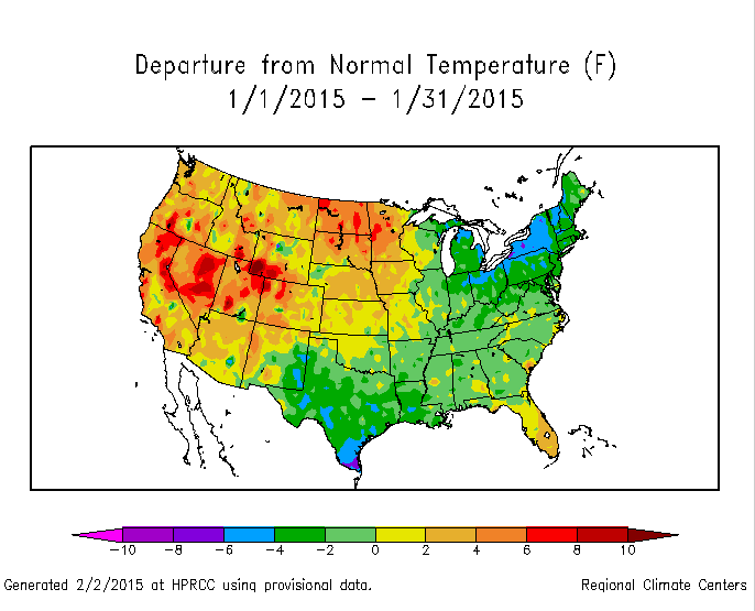
The national temperature anomaly map
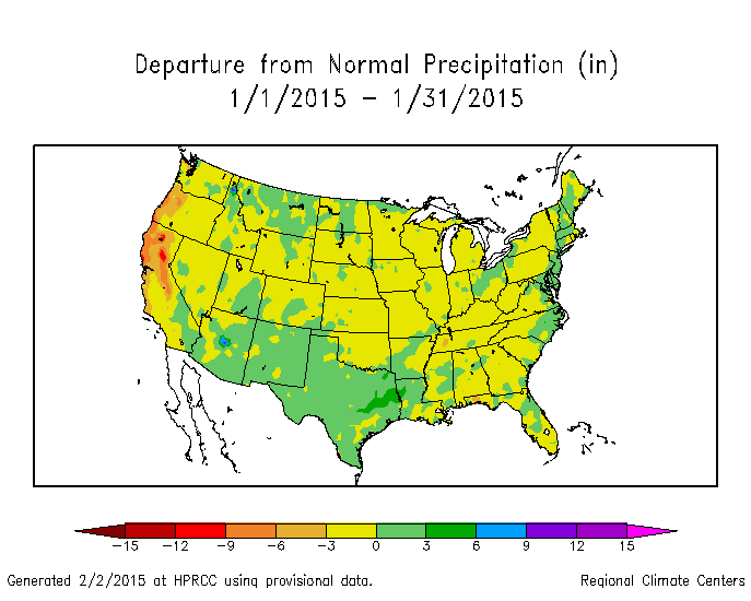
Now let’s take a look at precipitation anomalies. For the most part, it was dry. In some of our local counties it was very dry.
We averaged below normal (VERY boring weather during the Month of January – pretty much nationwide).
That receives one big YAWN from me.
The uncertainties part of the e-journal spells out where I am not confident in the forecast. I always tell people to pay attention to the whole forecast and not just the part they want to hear.
Weather is rarely yes or no. Weather forecasts are made up of probabilities. If someone tells you that it is going to snow 1.7 inches in your backyard then I am not sure you should trust their forecast. Why? Because meteorology has not come that far. Not yet, anyway. I can tell you that you should receive 1″-3″ of snow. Yes. I can do that. I can not tell you that your backyard will receive 1.7 inches of snow. Sorry, if you are looking for that forecast then look elsewhere.
The uncertainties in this update center around Wednesday night. A cold front will enter our northern counties by late Wednesday afternoon. This front will be accompanied by light precipitation and falling temperatures. All of the data indicates precipitation totals will be on the light side. But, the problem is that wet roadways with falling temperatures could cause problems.
Temperatures are forecast to fall into the 20’s by Thursday morning. Teens are possible for parts of southern Illinois. Light rain changing to light snow with those temperatures could spell problems for some roadways. This is especially true if roads are not treated. Monitor updates as we move forward.
WANT TO HELP SUPPORT THIS BLOG AND COVER EXPENSES?
Did you know that the Weather Observatory is funded by people like you? I rely on ad’s on this blog and individual donations. PayPal also allows you to set up a monthly recurring donation. I have had several people give $5, $10, and $20 a month. A recurring donation helps keep the weather information flowing. If you enjoy this blog, the Twitter account, the Facebook interaction, the weather radars, and all of the other information then consider making a donation or setting up a recurring donation (if you don’t use PayPal then contact me through email about how you can mail a donation) beaudodson@usawx.com
Or mail a check to
Beau Dodson
3954 Mermet Road
Belknap, IL
62908
Thank you for your support!

No major changes in this update.

Concerns center around Wednesday night. Light snow with falling temperatures could spell some slick roadways.
Check out our newest sponsors $5 meal! The DQ Grill and Chill (located across from Noble Park in Paducah, Kentucky) is the newest WeatherTalk Blog sponsor! A local business helping to sponsor the weather information that you have come to love so much.
They have a Facebook Page and I encourage you to check it out. DQ Grill and Chill on Facebook


The wild card tells you where the uncertainties are in the forecast
Wild card in this forecast – The wild card is centered on Wednesday nights snowfall totals. A bit early to be specific. Most of the data indicates at least a dusting to perhaps an inch or so. Still some time to figure this out. The main concern will be rapidly falling temperatures with moisture on roadways (Wednesday night)

Can we expect severe thunderstorms over the next 24 to 48 hours? Remember that a severe thunderstorm is defined as a thunderstorm that produces 58 mph winds or higher, quarter size hail or larger, and/or a tornado.
Thunderstorm threat level is ZERO


Will I need to take action?
Not today. Monitor Wednesday night into Thursday morning.

How much precipitation should we expect over the next few days?
Rainfall and snowfall totals will be light on Wednesday afternoon into Wednesday night.
Focus won’t be on totals but impact. Icy roads are a good bet by late Wednesday night and Thursday morning.
We have a new sponsor! G&C Multi-Services out of Paducah, Kentucky. G & C Multi-Services is a service provider in Western Kentucky that provides industrial and commercial equipment fabrication, machine troubleshooting, repair and maintenance, and installation. They can custom fabricate steel, stainless, and aluminum products per customer specifications.
Visit their web-site here. Or click the ad below! They have a Facebook page and it can be viewed here.


Tracking a system for Wednesday afternoon and night.
Light rain will develop late on Wednesday afternoon. This rain will change to snow on Wednesday night. Totals will be light. There is likely, however, going to be some icy road conditions as temperatures fall into the teens and 20’s on Wednesday night and Thursday morning.
Wet roadways will freeze. A light snow event on top of that will cause some problems.
Although this is not forecast to be a heavy snow event, it could be a higher than usual impact event based on rapidly falling temperatures.
Here is a photograph I took on Tuesday – Chicago. Nearly 20 inches of snow fell on the windy city!

This section of the blog is speculative forecast information. Because it is past the range of what meteorologists can forecast accurately, it should be considered speculation. Anything past day 5 is considered a long range forecast.
The weather will be calm on Thursday into Saturday. Thursday and Friday will be colder than normal. Saturday and Sunday will bring above normal temperatures.
Here are the high temperature forecasts for Saturday and Sunday – maybe we can squeak out some upper 40’s to near 50. Meteorological spring is now 26 days away. Winter will be over in a blink.
and Sunday

Who do you trust for your weather information and who holds them accountable?
I have studied weather in our region since the late 1970’s. I have 37 years of experience in observing our regions weather patterns. My degree is in Broadcast Meteorology from Mississippi State University and an Associate of Science (AS). I am currently working on my Bachelor’s Degree in Geoscience. Just need to finish two Spanish classes!
I am a member of the American Meteorological Society. I am a NOAA Weather-Ready Nation Ambassador. And, I am the Meteorologist for McCracken County Emergency Management.
I own and operate the Southern Illinois Weather Observatory.
There is a lot of noise on the internet. A lot of weather maps are posted without explanation. Over time you should learn who to trust for your weather information.
My forecast philosophy is simple and straight forward.
- Communicate in simple terms
- To be as accurate as possible within a reasonable time frame before an event
- Interact with you on Twitter, Facebook, and the blog
- Minimize the “hype” that you might see on television or through other weather sources
- Push you towards utilizing wall-to-wall LOCAL TV coverage during severe weather events
I am a recipient of the Mark Trail Award, WPSD Six Who Make A Difference Award, Kentucky Colonel, and the Caesar J. Fiamma” Award from the American Red Cross. In 2009 I was presented with the Kentucky Office of Highway Safety Award. I was recognized by the Kentucky House of Representatives for my service to the State of Kentucky leading up to several winter storms and severe weather outbreaks.
If you click on the image below you can read the Kentucky House of Representatives Resolution.

I am also President of the Shadow Angel Foundation which serves portions of western Kentucky and southern Illinois.

We have regional radars and local city radars – if a radar does not seem to be updating then try another one. Occasional browsers need their cache cleared. You may also try restarting your browser. That usually fixes the problem. Occasionally we do have a radar go down. That is why I have duplicates. Thus, if one fails then try another one.
If you have any problems then please send me an email beaudodson@usawx.com
WEATHER RADAR PAGE – Click here —
We also have a new national interactive radar – you can view that radar by clicking here.
Local interactive city radars include St Louis, Mt Vernon, Evansville, Poplar Bluff, Cape Girardeau, Marion, Paducah, Hopkinsville, Memphis, Nashville, Dyersburg, and all of eastern Kentucky – these are interactive radars. Local city radars – click here
NOTE: Occasionally you will see ground clutter on the radar (these are false echoes). Normally they show up close to the radar sites – including Paducah.

Regional Radar – Click on radar to take you our full radar page.


Regional Radar
![]()
Current WARNINGS (a warning means take action now). Click on your county to drill down to the latest warning information. Keep in mind that there can be a 2-3 minute delay in the updated warning information.
I strongly encourage you to use a NOAA Weather Radio or warning cell phone app for the most up to date warning information. Nothing is faster than a NOAA weather radio.


Color shaded counties are under some type of watch, warning, advisory, or special weather statement. Click your county to view the latest information.

Missouri Warnings

Illinois Warnings

Kentucky Warnings

Please visit your local National Weather Service Office by clicking here. The National Weather Service Office, for our region, is located in Paducah, Kentucky. They have a lot of maps and information on their site. Local people…local forecasters who care about our region.


Here is the official 6-10 day and 8-14 day temperature and precipitation outlook. Check the date stamp at the top of each image (so you understand the time frame).
The forecast maps below are issued by the Weather Prediction Center (NOAA).


The latest 8-14 day temperature and precipitation outlook. Note the dates are at the top of the image. These maps DO NOT tell you how high or low temperatures or precipitation will be. They simply give you the probability as to whether temperatures or precipitation will be above or below normal.


Many of my graphics are from www.weatherbell.com – a great resource for weather data, model data, and more


This blog was inspired by ABC 33/40’s Alabama Weather Blog – view their blog
Current tower cam view from the Weather Observatory- Click here for all cameras.

Southern Illinois Weather Observatory

The Weather Observatory

Southern Illinois Weather Observatory
WSIL TV 3 has a number of tower cameras. Click here for their tower camera page & Illinois Road Conditions

Marion, Illinois
WPSD TV 6 has a number of tower cameras. Click here for their tower camera page & Kentucky Road Conditions & Kentucky Highway and Interstate Cameras

Downtown Paducah, Kentucky
Benton, Kentucky Tower Camera – Click here for full view

Benton, Kentucky

I24 Paducah, Kentucky

I24 Mile Point 9 – Paducah, KY

I24 – Mile Point 3 Paducah, Kentucky

You can sign up for my AWARE email by clicking here I typically send out AWARE emails before severe weather, winter storms, or other active weather situations. I do not email watches or warnings. The emails are a basic “heads up” concerning incoming weather conditions.