We have our first sponsor for the blog. Milner and Orr Funeral Home and Cremation Services located in Paducah, Kentucky and three other western Kentucky towns – at Milner and Orr they believe in families helping families.
![]()

This forecast update covers far southern Illinois, far southeast Missouri, and far western Kentucky. See the coverage map on the right side of the blog.
Remember that weather evolves. Check back frequently for updates, especially during active weather.
Monday – Mix of sun and clouds. Colder. Flurry possible. Highs only in the 20’s. Northwest winds at 10-15 mph with gusts to 20 mph early. Winds tapering during the afternoon hours. Confidence is high in this part of the forecast.
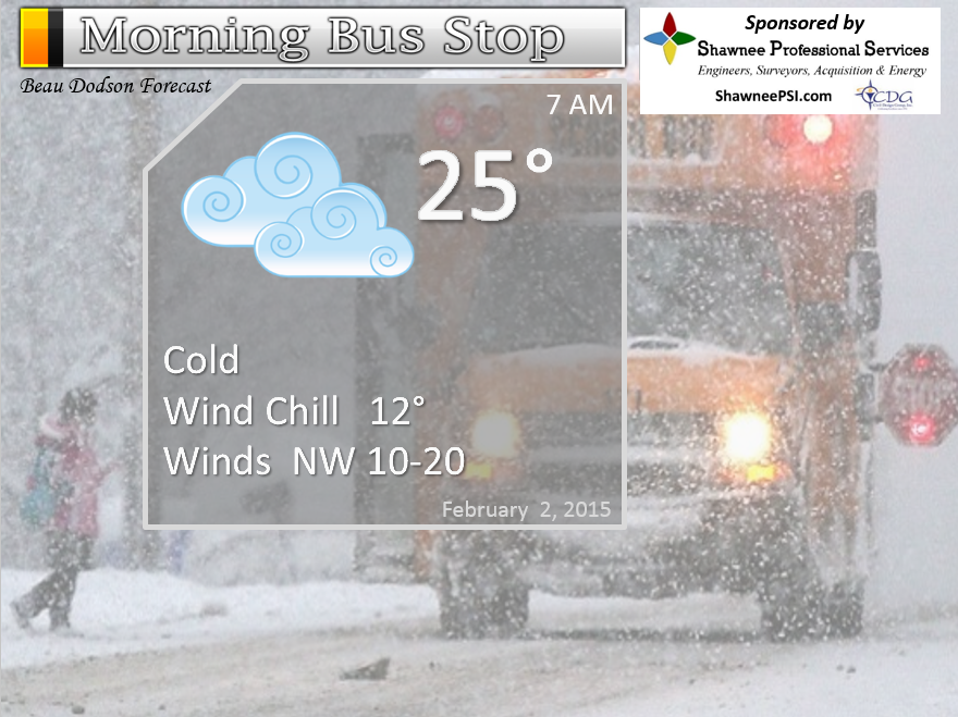
Morning School Bus Stop Weather – Some clouds. Cold. Windy at times. Temperatures only in the 20’s with wind chills in the teens. Northwest wind 10-20 mph. Chances of schools being delayed because of the weather? 5%
—————————————————————————————-
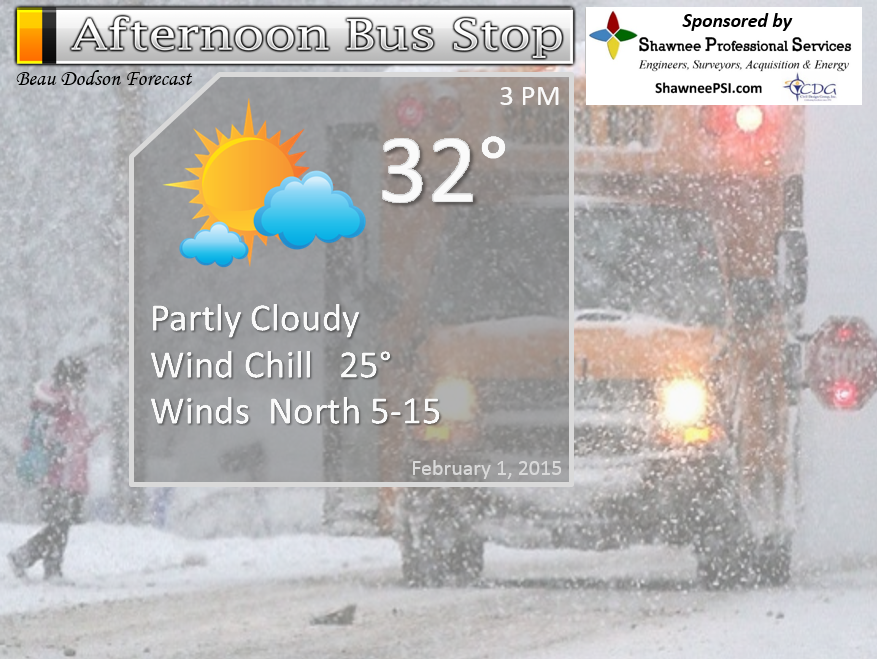
Afternoon School Bus Stop Weather – Partly cloudy and cold. Temperatures at 3 pm will only be in the upper 20’s and lower 30’s. Northwest winds at 10-15 mph. Wind chills upper teens to lower 20’s.
Monday night – Partly cloudy and cold. Low temperatures mainly in the 20’s. Northwest winds at 5-10 mph. Confidence is high in this part of the forecast.
Tuesday – Partly cloudy and cold. Highs mainly in the 40’s. South/southwest winds at 10-15 mph. Confidence is high in this part of the forecast.
Tuesday night – Partly cloudy and cold. Low temperatures mainly in the upper 20’s to near 30 degrees. Southwest winds at 5-10 mph. Confidence is high in this part of the forecast.
Wednesday – Becoming cloudy with falling temperatures during the afternoon. A chance for an afternoon light shower. Highs mainly in the 40’s but falling in the afternoon. South/southwest winds at 10-15 mph becoming north/northwest at 10-20 mph and gusty. Confidence is high in this part of the forecast.
We may have some light snow showers on Wednesday night. Still early to make a call on that one.

The School Bus Stop Forecast is brought to your by Shawnee Professional Services. For more information click here
Current Temperatures Around The Local Area


An explanation of what is happening in the atmosphere over the coming days…
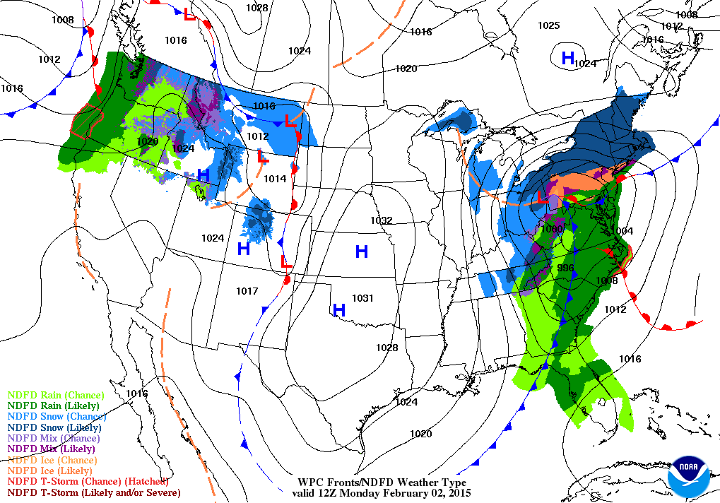
Well, as promised there was widespread rain on Sunday across our region. Rainfall totals of greater than 0.50″ were reported in most counties. A cold rain. Nothing worse than cold rain. Not the best weather for man or beast.
A big winter storm struck parts of central and northern Illinois. Blizzard warnings were even issued for parts of northeast Illinois. But, that was north of our region, as expected.
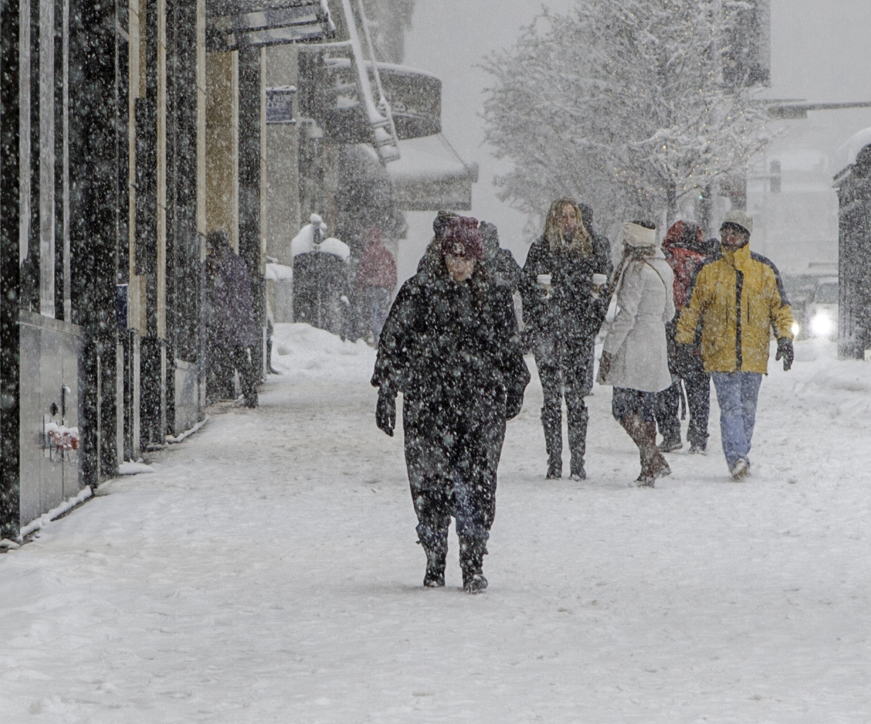
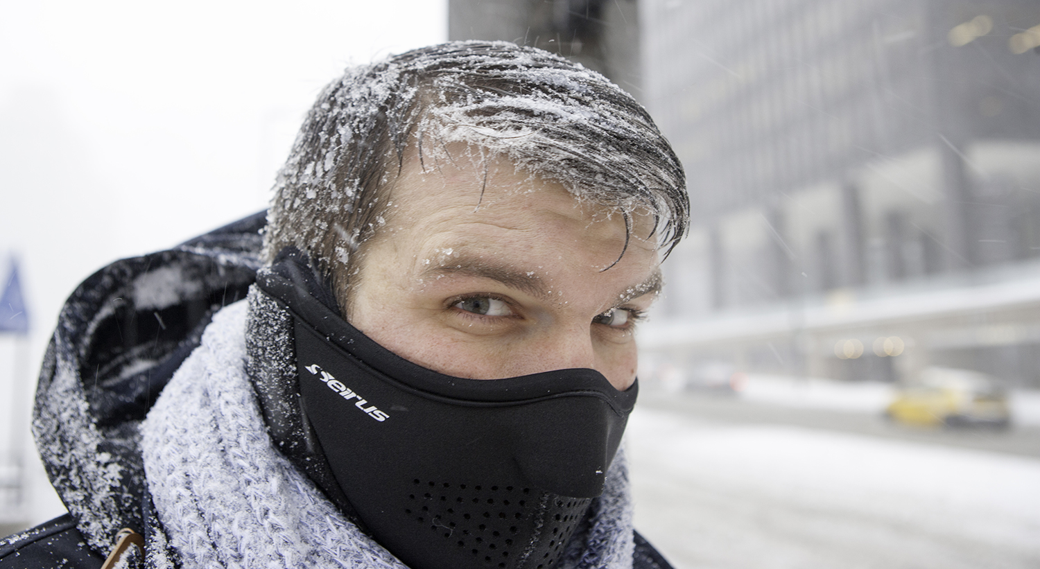
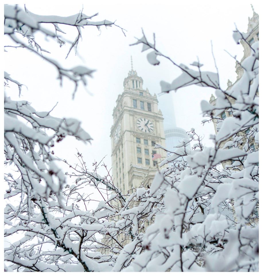
A couple of photos I took while I was out and about on Michigan Avenue
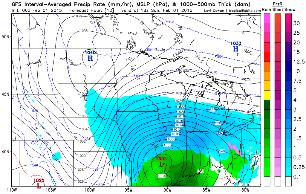
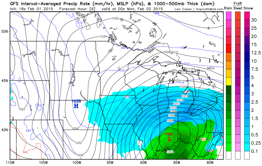
Here is a look at the weather map as the blizzard moved across Illinois on Sunday morning and afternoon
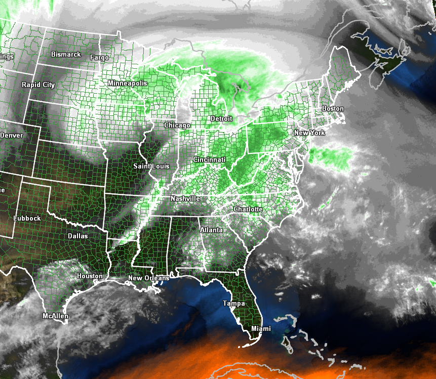
Sunday evening water vapor satellite view of the massive storm
Monday is going to start out chilly with temperatures only in the 20’s. Brr! By tonight we will start to see winds shifting around to the south again. Tuesday will bring southerly winds and moderating temperatures. Expect highs into the 40’s! That would be near normal temperatures.
This morning’s weather map
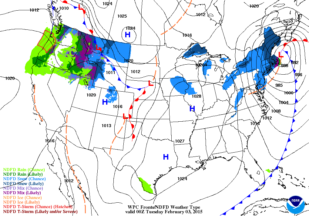
You can see the blizzard pulling away to the northeast. This system will bring additional snow to the hard hit areas of the northeast. Our region, on the other hand, will be left with calm weather as high pressure builds back into the area.
This evening’s weather map also indicates calm weather conditions in our local area. Just a few snow showers over northern Illinois. High pressure is located over our local area.
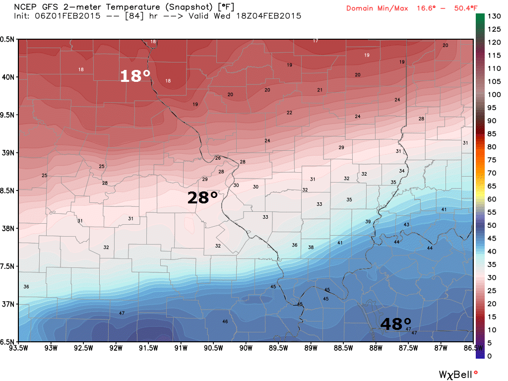
Another cold front arrives on Wednesday night into Thursday. This cold front will be accompanied by gusty winds and falling temperatures. A period of light rain and snow also appears possible. Right now it is still too soon to mention snowfall totals. You know how that song and dance goes. DO NOT forecast snowfall totals days in advance.
Temperatures will be colder on Thursday and Friday. Perhaps Thursday night being the coldest night of the next seven days.
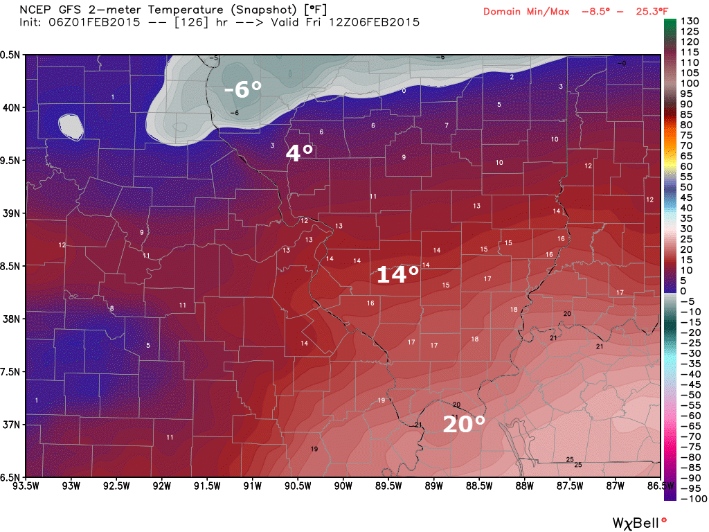
Check out the temperatures ahead and behind the cold front on Wednesday afternoon and evening. Images from www.weatherbell.com
By Friday morning temperatures will be quite cold over our region
The uncertainties part of the e-journal spells out where I am not confident in the forecast. I always tell people to pay attention to the whole forecast and not just the part they want to hear.
Weather is rarely yes or no. Weather forecasts are made up of probabilities. If someone tells you that it is going to snow 1.7 inches in your backyard then I am not sure you should trust their forecast. Why? Because meteorology has not come that far. Not yet, anyway. I can tell you that you should receive 1″-3″ of snow. Yes. I can do that. I can not tell you that your backyard will receive 1.7 inches of snow. Sorry, if you are looking for that forecast then look elsewhere.
Uncertainties in today’s update – The uncertainties in the forecast are going to center around the chance for some light precipitation on Wednesday night into Thursday. Right now it appears that we will have at least a chance for rain or snow during that time period. A cold front will drop into the area on Wednesday night. Some moisture along the front means that we will have at least chances for some rain and snow.
Too soon to know whether or not this might be a situation where snow will stick or accumulate. Monitor updates as more data becomes available. There is a higher than usual uncertainty, concerning weather conditions, centered around the Wednesday night into Thursday time frame.
WANT TO SUPPORT THIS BLOG AND HELP COVER EXPENSES?
Did you know that the Weather Observatory is funded by people like you? I rely on ad’s on this blog and individual donations. PayPal also allows you to set up a monthly recurring donation. I have had several people give $5, $10, and $20 a month. A recurring donation helps keep the weather information flowing. If you enjoy this blog, the Twitter account, the Facebook interaction, the weather radars, and all of the other information then consider making a donation or setting up a recurring donation (if you don’t use PayPal then contact me through email about how you can mail a donation) beaudodson@usawx.com
Or mail me at
Beau Dodson
3954 Mermet Road
Belknap, IL
62908
Thank you for your support!

No changes to the forecast!

No major weather concerns or problems today or tonight. Calm.
Check out our newest sponsors $5 meal! The DQ Grill and Chill (located across from Noble Park in Paducah, Kentucky) is the newest WeatherTalk Blog sponsor! A local business helping to sponsor the weather information that you have come to love so much.
They have a Facebook Page and I encourage you to check it out. DQ Grill and Chill on Facebook


The wild card tells you where the uncertainties are in the forecast
Wild card in this forecast – No wild card today.

Can we expect severe thunderstorms over the next 24 to 48 hours? Remember that a severe thunderstorm is defined as a thunderstorm that produces 58 mph winds or higher, quarter size hail or larger, and/or a tornado.
Thunderstorm threat level is ZERO

Warnings


Will I need to take action?
Maybe a couple of slick spots this morning from moisture that was leftover on area roadways. Otherwise, no action required. Coat weather!

How much precipitation should we expect over the next few days?
No rain or snow today through Wednesday morning!
Light precipitation possible around Wednesday evening into Wednesday night.
We have a new sponsor! G&C Multi-Services out of Paducah, Kentucky. G & C Multi-Services is a service provider in Western Kentucky that provides industrial and commercial equipment fabrication, machine troubleshooting, repair and maintenance, and installation. They can custom fabricate steel, stainless, and aluminum products per customer specifications.
Visit their web-site here. Or click the ad below! They have a Facebook page and it can be viewed here.


Another cold front approaches our region on Wednesday. This front will usher in another shot of cold air. Below normal temperatures for Wednesday night into Friday. Then we pop back to near seasonable levels for the weekend.
The front will likely be accompanied by light rain and possibly a change-over to light snow showers. Right now it is too soon to talk about accumulations.
Remember, we never count our snowflakes before they hatch.

This section of the blog is speculative forecast information. Because it is past the range of what meteorologists can forecast accurately, it should be considered speculation. Anything past day 5 is considered a long range forecast.
Below normal temperatures on Thursday and Friday. Then we return to seasonable air on Saturday and Sunday.
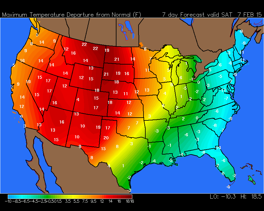
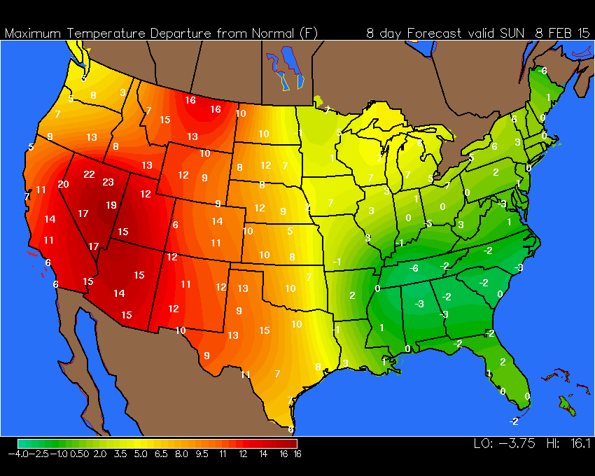
Here are the high temperature departures for Saturday and Sunday. Above normal temps across most of the nation. Anyone remember those almanac forecasts for the worst winter in decades? Hmmm – did they mean the most boring winter in decades?
Normal high temperatures for this time of the year are in the middle 40’s.
Saturday’s High Temperature Departures – how many degrees above normal will temperatures be on Saturday?
Sunday’s High Temperature Departures – how many degrees above normal will temperatures be on Sunday?

Who do you trust for your weather information and who holds them accountable?
I have studied weather in our region since the late 1970’s. I have 37 years of experience in observing our regions weather patterns. My degree is in Broadcast Meteorology from Mississippi State University and an Associate of Science (AS). I am currently working on my Bachelor’s Degree in Geoscience. Just need to finish two Spanish classes!
I am a member of the American Meteorological Society. I am a NOAA Weather-Ready Nation Ambassador. And, I am the Meteorologist for McCracken County Emergency Management.
I own and operate the Southern Illinois Weather Observatory.
There is a lot of noise on the internet. A lot of weather maps are posted without explanation. Over time you should learn who to trust for your weather information.
My forecast philosophy is simple and straight forward.
- Communicate in simple terms
- To be as accurate as possible within a reasonable time frame before an event
- Interact with you on Twitter, Facebook, and the blog
- Minimize the “hype” that you might see on television or through other weather sources
- Push you towards utilizing wall-to-wall LOCAL TV coverage during severe weather events
I am a recipient of the Mark Trail Award, WPSD Six Who Make A Difference Award, Kentucky Colonel, and the Caesar J. Fiamma” Award from the American Red Cross. In 2009 I was presented with the Kentucky Office of Highway Safety Award. I was recognized by the Kentucky House of Representatives for my service to the State of Kentucky leading up to several winter storms and severe weather outbreaks.
If you click on the image below you can read the Kentucky House of Representatives Resolution.

I am also President of the Shadow Angel Foundation which serves portions of western Kentucky and southern Illinois.

We have regional radars and local city radars – if a radar does not seem to be updating then try another one. Occasional browsers need their cache cleared. You may also try restarting your browser. That usually fixes the problem. Occasionally we do have a radar go down. That is why I have duplicates. Thus, if one fails then try another one.
If you have any problems then please send me an email beaudodson@usawx.com
WEATHER RADAR PAGE – Click here —
We also have a new national interactive radar – you can view that radar by clicking here.
Local interactive city radars include St Louis, Mt Vernon, Evansville, Poplar Bluff, Cape Girardeau, Marion, Paducah, Hopkinsville, Memphis, Nashville, Dyersburg, and all of eastern Kentucky – these are interactive radars. Local city radars – click here
NOTE: Occasionally you will see ground clutter on the radar (these are false echoes). Normally they show up close to the radar sites – including Paducah.

Regional Radar – Click on radar to take you our full radar page.


Regional Radar

Please visit your local National Weather Service Office by clicking here. The National Weather Service Office, for our region, is located in Paducah, Kentucky. They have a lot of maps and information on their site. Local people…local forecasters who care about our region.

Here is the official 6-10 day and 8-14 day temperature and precipitation outlook. Check the date stamp at the top of each image (so you understand the time frame).
The forecast maps below are issued by the Weather Prediction Center (NOAA).


The latest 8-14 day temperature and precipitation outlook. Note the dates are at the top of the image. These maps DO NOT tell you how high or low temperatures or precipitation will be. They simply give you the probability as to whether temperatures or precipitation will be above or below normal.


Many of my graphics are from www.weatherbell.com – a great resource for weather data, model data, and more


This blog was inspired by ABC 33/40’s Alabama Weather Blog – view their blog
Current tower cam view from the Weather Observatory- Click here for all cameras.

Southern Illinois Weather Observatory

The Weather Observatory

Southern Illinois Weather Observatory
WSIL TV 3 has a number of tower cameras. Click here for their tower camera page & Illinois Road Conditions

Marion, Illinois
WPSD TV 6 has a number of tower cameras. Click here for their tower camera page & Kentucky Road Conditions & Kentucky Highway and Interstate Cameras

Downtown Paducah, Kentucky
Benton, Kentucky Tower Camera – Click here for full view

Benton, Kentucky

I24 Paducah, Kentucky

I24 Mile Point 9 – Paducah, KY

I24 – Mile Point 3 Paducah, Kentucky

You can sign up for my AWARE email by clicking here I typically send out AWARE emails before severe weather, winter storms, or other active weather situations. I do not email watches or warnings. The emails are a basic “heads up” concerning incoming weather conditions.