
We have our first sponsor for the blog. Milner and Orr Funeral Home and Cremation Services located in Paducah, Kentucky and three other western Kentucky towns – at Milner and Orr they believe in families helping families.
![]()

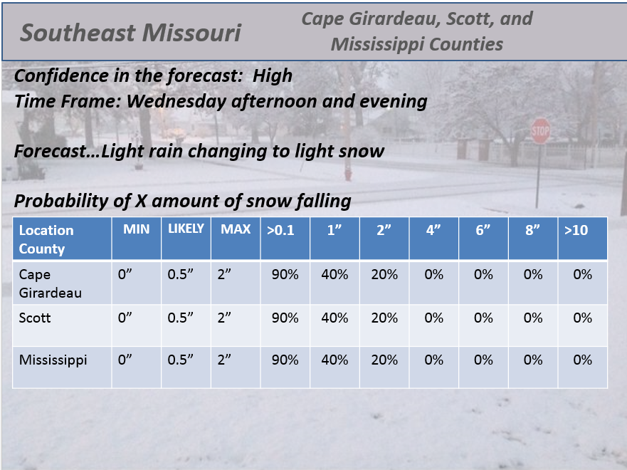
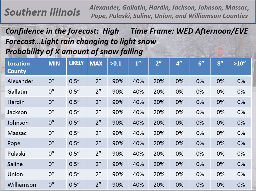
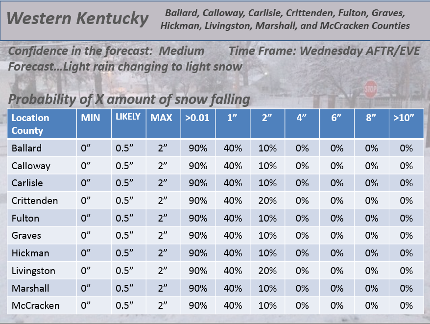
This forecast update covers far southern Illinois, far southeast Missouri, and far western Kentucky. See the coverage map on the right side of the blog.
Remember that weather evolves. Check back frequently for updates, especially during active weather.
Wednesday – Becoming cloudy with rain and light snow developing late in the afternoon over our northern counties. Dry elsewhere. Temperatures in the lower 50’s for west KY and falling into the 30’s late in the day over northern parts of southern Illinois. My confidence in this part of the forecast verifying is medium
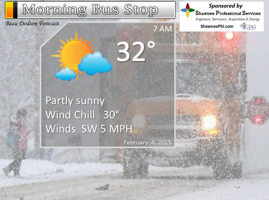
Morning School Bus Stop Weather – Some morning sunshine. Morning temperatures will be in the 20’s to lower 30’s. Chances of schools being delayed because of the weather 0%
—————————————————————————————-
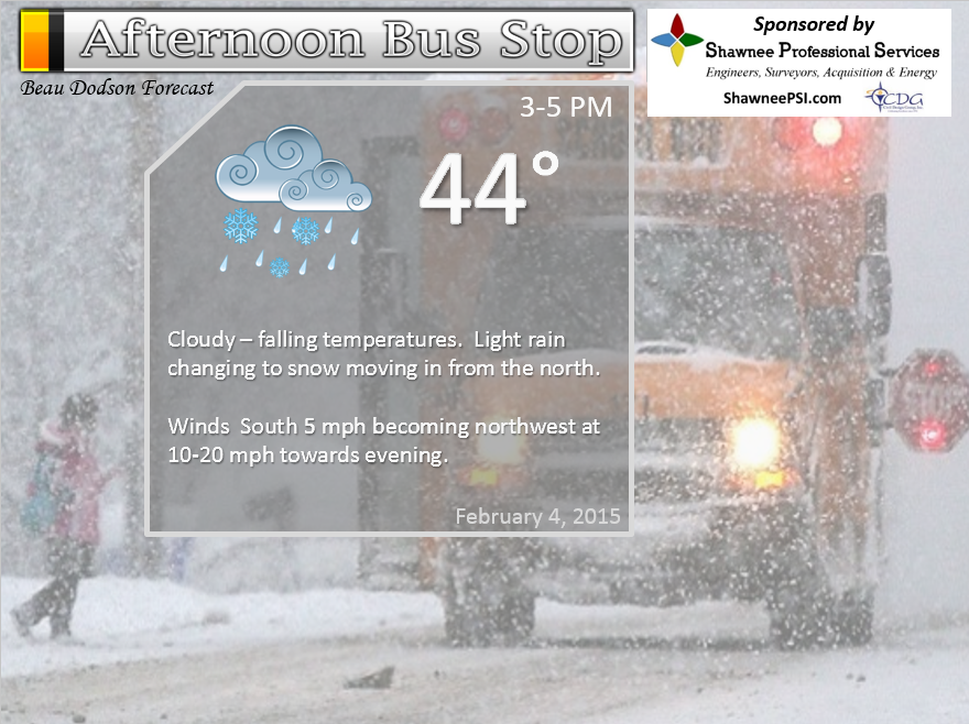
Afternoon School Bus Stop Weather – A chance for light rain and light snow over our northern counties. Falling temperatures. Temperatures will vary quite a bit from north to south. Temperatures by 3 pm will be in the 20’s in Mt Vernon. Temperatures in Paducah at 3 pm will still be in the 40’s. Winds switching out of the north/northwest at 10-15 mph. Gusty at times – especially the further north you go in the area.
Wednesday night – A period of light snow. Some icy roads will be possible as temperatures fall into the teens. Lows by Thursday morning may approach 8-12 degrees in Mt Vernon. Temperatures over far southern Illinois and western Kentucky will be in the teens and lower 20’s. Gusty northwest winds at 10-20 mph. Winds dying down after midnight. My confidence in this part of the forecast verifying is high
Some spots will pick up no measurable snow. Others will have a dusting to an inch or so. The inch or so is most likely over northern counties of southern Illinois and northern counties of southeast Missouri. This is BARELY a snow event.
Thursday – Partly cloudy and cold. Highs only in the 20’s. North winds at 10 mph. My confidence in this part of the forecast verifying is high
Thursday night – Clearing and cold. Lows in the teens and lower 20’s. Northeast winds becoming southeast winds at 10 mph. My confidence in this part of the forecast verifying is high
Friday – Partly sunny and cold. Highs in the upper 30’s and lower 40’s. My confidence in this part of the forecast verifying is high

The School Bus Stop Forecast is brought to your by Shawnee Professional Services. For more information click here
Current Temperatures Around The Local Area


An explanation of what is happening in the atmosphere over the coming days…
A strong cold front will push into the area today. The front will be accompanied by gusty winds and light precipitation.
A period of light rain changing to light snow will develop over our northern counties during the early afternoon. This area of light precipitation will push southward during the late afternoon and evening hours. The light precipitation may not reach western Kentucky until after 5 pm.
Some questions remain on the exact timing from one county to the next. I know it will approach Mt Vernon during the early afternoon and then push southward from there.
Thinking is that it will approach Carbondale and Marion, Illinois between 2 pm and 5 pm. It will then advance southward into western Kentucky. Most likely after 4 or 5 pm for Paducah (evening hours).
There may be a dusting to an inch or so of snow will this system. Not much. The bigger concern will be wet roadways freezing as temperatures fall into the teens and 20’s.
Use care if you have to be out and about later this evening into Thursday morning. Treated roadways should be okay. Bridges and overpasses freeze first. Side roads and untreated roadways could have some slick spots.
Here is the weather map for Wednesday morning and Wednesday evening. You can see the movement of the cold front through our area.
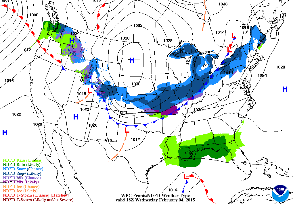
and evening
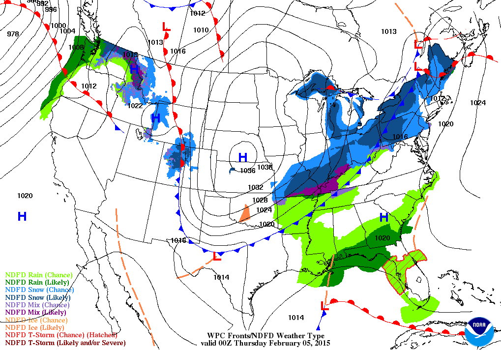
Thursday will bring calm and cold weather.
Radars
WEATHER RADAR PAGE – Click here —
The uncertainties part of the e-journal spells out where I am not confident in the forecast. I always tell people to pay attention to the whole forecast and not just the part they want to hear.
Weather is rarely yes or no. Weather forecasts are made up of probabilities. If someone tells you that it is going to snow 1.7 inches in your backyard then I am not sure you should trust their forecast. Why? Because meteorology has not come that far. Not yet, anyway. I can tell you that you should receive 1″-3″ of snow. Yes. I can do that. I can not tell you that your backyard will receive 1.7 inches of snow. Sorry, if you are looking for that forecast then look elsewhere.
Uncertainties today surround the potential for light rain and light snow later today. I am confident that widespread light precipitation is going to push southward into our local counties later this afternoon and this evening. Whether or not this system can produce enough snow to dust or cover the ground is where the uncertainties are. I am going to post the probabilities below.
The probabilities will give you an idea of what to expect. What are the odds of X amount of snow occurring in your county. I have tried to make this easy to understand. Some people don’t like probabilities (I am one of them). But, with weather – probabilities are how forecasts are made.
WANT TO HELP SUPPORT THIS BLOG AND COVER EXPENSES?
Did you know that the Weather Observatory is funded by people like you? I rely on ad’s on this blog and individual donations. PayPal also allows you to set up a monthly recurring donation. I have had several people give $5, $10, and $20 a month. A recurring donation helps keep the weather information flowing. If you enjoy this blog, the Twitter account, the Facebook interaction, the weather radars, and all of the other information then consider making a donation or setting up a recurring donation (if you don’t use PayPal then contact me through email about how you can mail a donation) beaudodson@usawx.com
Or mail a check to
Beau Dodson
3954 Mermet Road
Belknap, IL
62908
Thank you for your support!

Drastically changed the arrival time. System has slowed down by 2-4 hours.

The chance for light rain changing to light snow later today. Falling temperatures could cause some icy roads. Use care if you have to be out and about later today and especially into tonight and tomorrow morning. A light precipitation event. We all know how to drive. So, just use care! Let’s not give those northerner’s a reason to laugh at us southern folk.
Check out our newest sponsors $5 meal! The DQ Grill and Chill (located across from Noble Park in Paducah, Kentucky) is the newest WeatherTalk Blog sponsor! A local business helping to sponsor the weather information that you have come to love so much.
They have a Facebook Page and I encourage you to check it out. DQ Grill and Chill on Facebook


The wild card tells you where the uncertainties are in the forecast
Wild card in this forecast – the wild card today is an obvious one! How much light snow will fall tonight. Some places will likely end up with almost nothing. Flakes in the air, as I like to call them. Other areas will have a decent dusting to perhaps an inch or so. The best chance for an inch or so of snow will probably be across southeast Missouri and southern Illinois. The further south you travel the less likely there will be an inch or so.
Again, splitting snowflakes here. Dusting or an inch. Basically the same difference. Academics at that point.
The other part of the wild card is the exact timing of the arrival of precipitation as it pushes through southern Illinois and into western Kentucky. It should begin around 12 pm to 2 pm near Mt Vernon and then move southward from there.

Can we expect severe thunderstorms over the next 24 to 48 hours? Remember that a severe thunderstorm is defined as a thunderstorm that produces 58 mph winds or higher, quarter size hail or larger, and/or a tornado.
Thunderstorm threat level is ZERO!


Will I need to take action?
Yes, you will want to monitor both temperatures and the precipitation as it moves southward across our region later today. Some slick roadways are possible as light rain changes to light snow. Temperatures falling into the teens and lower 20’s by Thursday morning means that any moisture on roadways could freeze. Use a bit of extra caution.
Radars
WEATHER RADAR PAGE – Click here —

How much precipitation should we expect over the next few days?
Very light totals are forecast for the next 24 hours. Liquid amounts of 0.05 to 0.15″ is what I am expecting. If that were all snow then it would be a dusting to perhaps an inch or so. Some of that should be light rain. The light rain will change to light snow.
We have a new sponsor! G&C Multi-Services out of Paducah, Kentucky. G & C Multi-Services is a service provider in Western Kentucky that provides industrial and commercial equipment fabrication, machine troubleshooting, repair and maintenance, and installation. They can custom fabricate steel, stainless, and aluminum products per customer specifications.
Visit their web-site here. Or click the ad below! They have a Facebook page and it can be viewed here.

Well, I suppose in this winter of snow discontent that we will take what we can get. A strong cold front will swiftly move through the region later today. The front will be accompanied by rapidly falling temperatures, gusty winds, and a period of light rain changing to light snow.
This is not a major winter storm.
There may be enough moisture for a dusting of snow to perhaps an inch or so in a few counties. Best chance for the inch or so would be over southeast Missouri into southern Illinois. Don’t be surprised is some areas don’t even receive a dusting. We are only talking about 0.10″ of precipitation. If this was a summer rain then you probably would not even notice it.
We are really splitting snowflakes here. A dusting or an inch or so? Not much difference.
The problem is going to be rapidly falling temperatures. Temperatures by this evening will have fallen into the 20’s over parts of southeast Missouri and southern Illinois. The 20’s will slip into western Kentucky during the early evening hours.
By Thursday morning you can expect upper single digits near Mt Vernon to teens and lower 20’s over the rest of our area.
Untreated roadways may experience icing as temperatures fall. Use care if you have to be out later today into Thursday morning.
Again, focus for this event is on the impact of a bit of ice forming on roadways vs actual snowfall accumulations (which will be light).

This section of the blog is speculative forecast information. Because it is past the range of what meteorologists can forecast accurately, it should be considered speculation. Anything past day 5 is considered a long range forecast.
Another chance for precipitation will arrive around Sunday night or Monday. This will be along yet another cold front. A little unsure on temperatures over our area during the precipitation event. I will need to update this part of the forecast tomorrow. I spent a little more time today focusing on the precipitation potential for later today (Wednesday).
Temperatures by Saturday and Sunday will push above normal. Normal highs this time of the year are in the 40’s. Normal lows are in the 20’s. Some counties might even touch 50 on Saturday. Woohoo!
Meteorological spring is only a few weeks away. It begins on March 1st! But, who is counting. 🙂

Who do you trust for your weather information and who holds them accountable?
I have studied weather in our region since the late 1970’s. I have 37 years of experience in observing our regions weather patterns. My degree is in Broadcast Meteorology from Mississippi State University and an Associate of Science (AS). I am currently working on my Bachelor’s Degree in Geoscience. Just need to finish two Spanish classes!
I am a member of the American Meteorological Society. I am a NOAA Weather-Ready Nation Ambassador. And, I am the Meteorologist for McCracken County Emergency Management.
I own and operate the Southern Illinois Weather Observatory.
There is a lot of noise on the internet. A lot of weather maps are posted without explanation. Over time you should learn who to trust for your weather information.
My forecast philosophy is simple and straight forward.
- Communicate in simple terms
- To be as accurate as possible within a reasonable time frame before an event
- Interact with you on Twitter, Facebook, and the blog
- Minimize the “hype” that you might see on television or through other weather sources
- Push you towards utilizing wall-to-wall LOCAL TV coverage during severe weather events
I am a recipient of the Mark Trail Award, WPSD Six Who Make A Difference Award, Kentucky Colonel, and the Caesar J. Fiamma” Award from the American Red Cross. In 2009 I was presented with the Kentucky Office of Highway Safety Award. I was recognized by the Kentucky House of Representatives for my service to the State of Kentucky leading up to several winter storms and severe weather outbreaks.
If you click on the image below you can read the Kentucky House of Representatives Resolution.

I am also President of the Shadow Angel Foundation which serves portions of western Kentucky and southern Illinois.

We have regional radars and local city radars – if a radar does not seem to be updating then try another one. Occasional browsers need their cache cleared. You may also try restarting your browser. That usually fixes the problem. Occasionally we do have a radar go down. That is why I have duplicates. Thus, if one fails then try another one.
If you have any problems then please send me an email beaudodson@usawx.com
WEATHER RADAR PAGE – Click here —
We also have a new national interactive radar – you can view that radar by clicking here.
Local interactive city radars include St Louis, Mt Vernon, Evansville, Poplar Bluff, Cape Girardeau, Marion, Paducah, Hopkinsville, Memphis, Nashville, Dyersburg, and all of eastern Kentucky – these are interactive radars. Local city radars – click here
NOTE: Occasionally you will see ground clutter on the radar (these are false echoes). Normally they show up close to the radar sites – including Paducah.

Regional Radar – Click on radar to take you our full radar page.


Regional Radar
![]()
Current WARNINGS (a warning means take action now). Click on your county to drill down to the latest warning information. Keep in mind that there can be a 2-3 minute delay in the updated warning information.
I strongly encourage you to use a NOAA Weather Radio or warning cell phone app for the most up to date warning information. Nothing is faster than a NOAA weather radio.


Color shaded counties are under some type of watch, warning, advisory, or special weather statement. Click your county to view the latest information.

Missouri Warnings

Illinois Warnings

Kentucky Warnings

Please visit your local National Weather Service Office by clicking here. The National Weather Service Office, for our region, is located in Paducah, Kentucky. They have a lot of maps and information on their site. Local people…local forecasters who care about our region.


Here is the official 6-10 day and 8-14 day temperature and precipitation outlook. Check the date stamp at the top of each image (so you understand the time frame).
The forecast maps below are issued by the Weather Prediction Center (NOAA).


The latest 8-14 day temperature and precipitation outlook. Note the dates are at the top of the image. These maps DO NOT tell you how high or low temperatures or precipitation will be. They simply give you the probability as to whether temperatures or precipitation will be above or below normal.


Many of my graphics are from www.weatherbell.com – a great resource for weather data, model data, and more


This blog was inspired by ABC 33/40’s Alabama Weather Blog – view their blog
Current tower cam view from the Weather Observatory- Click here for all cameras.

Southern Illinois Weather Observatory

The Weather Observatory

Southern Illinois Weather Observatory
WSIL TV 3 has a number of tower cameras. Click here for their tower camera page & Illinois Road Conditions

Marion, Illinois
WPSD TV 6 has a number of tower cameras. Click here for their tower camera page & Kentucky Road Conditions & Kentucky Highway and Interstate Cameras

Downtown Paducah, Kentucky
Benton, Kentucky Tower Camera – Click here for full view

Benton, Kentucky

I24 Paducah, Kentucky

I24 Mile Point 9 – Paducah, KY

I24 – Mile Point 3 Paducah, Kentucky

You can sign up for my AWARE email by clicking here I typically send out AWARE emails before severe weather, winter storms, or other active weather situations. I do not email watches or warnings. The emails are a basic “heads up” concerning incoming weather conditions.