We have some great sponsors for the Weather Talk Blog. Please let our sponsors know that you appreciate their support for the Weather Talk Blog.
Milner and Orr Funeral Home and Cremation Services located in Paducah, Kentucky and three other western Kentucky towns – at Milner and Orr they believe in families helping families. You can find Milner and Orr on Facebook, as well.
![]()
.

For all of your families eye care needs. Visit their web-site here. Or, you can also visit their Facebook page.
.

Best at Enabling Body Shop Profitability since 1996. Located In Paducah Kentucky and Evansville Indiana; serving all customers in between. They provide Customer Service, along with all the tools necessary for body shops to remain educated and competitive. Click the logo above for their main web-site. You can find McClintock Preferred Finishes on Facebook, as well
.

Duck/goose decoys? Game calls? Optics? We have you covered! Click the logo above or visit Final Flight on Facebook, as well.
I have launched the new weather texting service! I could use your help. Be sure and sign up and fully support all of the weather data you see each day.
This is a monthly subscription service. Supporting this helps support everything else. The cost is $3 a month for one phone, $5 a month for three phones, and $10 a month for seven phones.
For more information visit BeauDodsonWeather.com
Or directly sign up at Weathertalk.com


This forecast update covers far southern Illinois, far southeast Missouri, and far western Kentucky. See the coverage map on the right side of the blog.
Remember that weather evolves. Check back frequently for updates, especially during active weather.

Weather Radars
WEATHER RADAR PAGE – Click here —
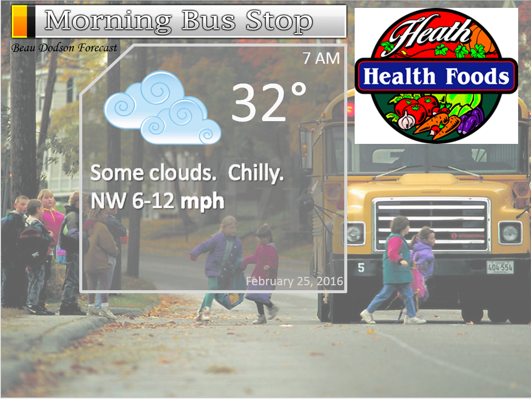
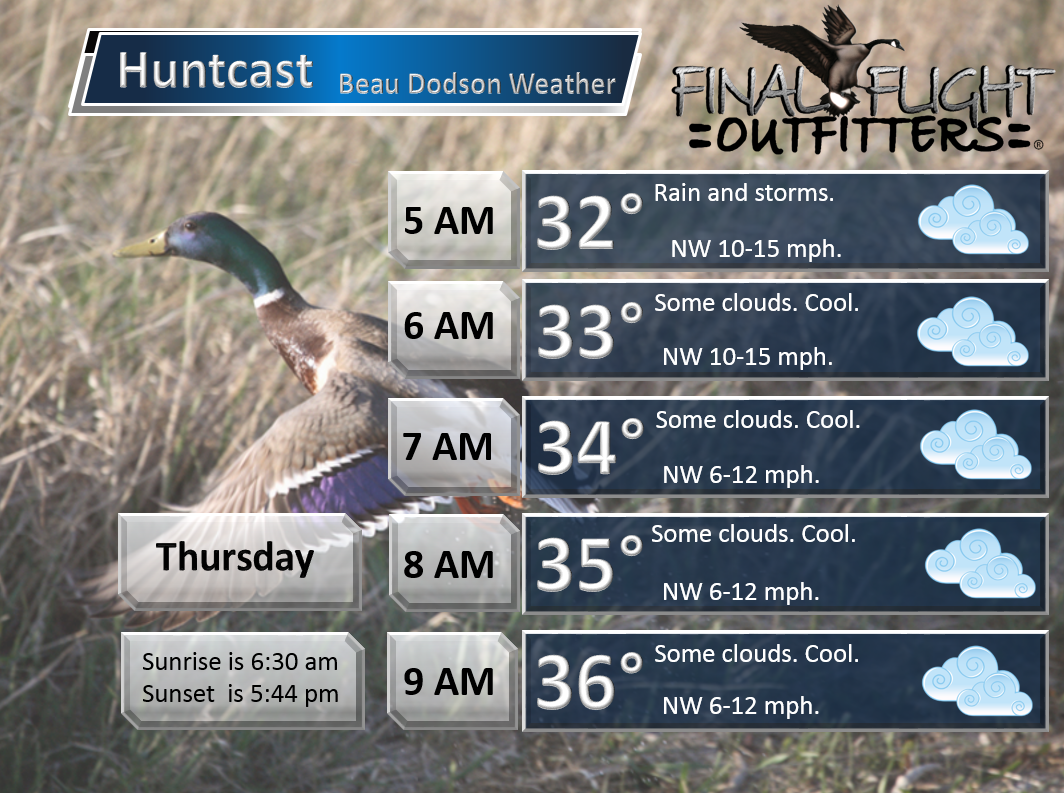
Wednesday Night – Cloudy. Fog possible. Breezy. A few rain or snow showers remaining.
Temperatures: Lows in the 30 to 35 degree range.
Winds: West/northwest winds at 10-15 mph. Gusty.
What is the chance for precipitation? 30%
Coverage of precipitation? Scattered
My confidence in this part of the forecast verifying is High
Should I be concerned about snow or ice? Unlikely
Should I cancel my outdoor plans? No, but it will be windy and cold.
Is severe weather expected? No.
What impact is expected? Small chance for slick spots. Fog possible.
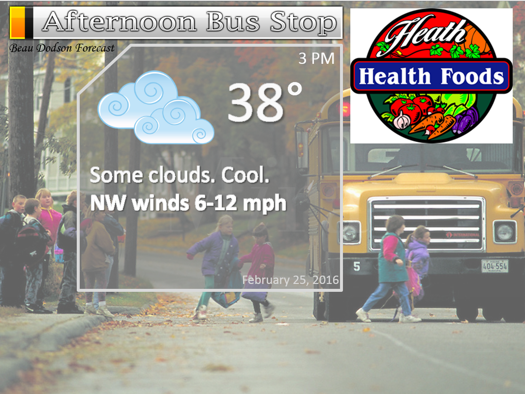
Thursday – Some clouds. Scattered flurries, rain showers, or light sleet. Nothing major. Temperatures are too warm.
Temperatures: Highs temperatures will mostly be in the upper 30s and lower 40s.
Winds: North and northwest at 5-10 mph.
What is the chance for precipitation? 30%
Coverage of precipitation? None
My confidence in this part of the forecast verifying is High
Should I be concerned about snow or ice? No major concerns. Spotty snow showers.
Should I cancel my outdoor plans? No
Is severe weather expected? No
What impact is expected? None expected.
Thursday Night – Partly cloudy and colder.
Temperatures: Lows in the 25-30 degree range.
Winds: West/northwest winds at 10-15 mph.
What is the chance for precipitation? 0%
Coverage of precipitation? None
My confidence in this part of the forecast verifying is High
Should I be concerned about snow or ice? No
Should I cancel my outdoor plans? No
Is severe weather expected? No.
What impact is expected? None
Friday – Partly sunny. Not as cold.
Temperatures: Highs temperatures will mostly be in the middle 40s.
Winds: West winds at 5 mph.
What is the chance for precipitation? 0%
Coverage of precipitation? None
My confidence in this part of the forecast verifying is High
Should I be concerned about snow or ice? No
Should I cancel my outdoor plans? No
Is severe weather expected? No
What impact is expected? None expected.
Friday Night – A few clouds. Cool.
Temperatures: Lows in the 30-35 degree range.
Winds: West/northwest winds at 0-5 mph.
What is the chance for precipitation? 0%
Coverage of precipitation? None
My confidence in this part of the forecast verifying is High
Should I be concerned about snow or ice? No
Should I cancel my outdoor plans? No
Is severe weather expected? No.
What impact is expected? None
Saturday – Partly sunny. Milder.
Temperatures: Highs temperatures 54-58 degree range.
Winds: Southwest winds at 4-8 mph.
What is the chance for precipitation? 0%
Coverage of precipitation? None
My confidence in this part of the forecast verifying is High
Should I be concerned about snow or ice? No
Should I cancel my outdoor plans? No
Is severe weather expected? No
What impact is expected? None expected.
Saturday Night – A few clouds.
Temperatures: Lows in the 40-45 degree range.
Winds: Southwest winds at 6-12 mph.
What is the chance for precipitation? 0%
Coverage of precipitation? None
My confidence in this part of the forecast verifying is High
Should I be concerned about snow or ice? No
Should I cancel my outdoor plans? No
Is severe weather expected? No.
What impact is expected? None
Sunday – Partly sunny and breezy. Mild.
Temperatures: Highs temperatures 64-68 degree range.
Winds: Southwest winds at 12-24 mph.
What is the chance for precipitation? 0%
Coverage of precipitation? None
My confidence in this part of the forecast verifying is High
Should I be concerned about snow or ice? No
Should I cancel my outdoor plans? No
Is severe weather expected? No
What impact is expected? None expected.

Heath Health Foods is a locally owned and operated retail health and wellness store. Since opening in February 2006; the store has continued to grow as a ministry with an expanding inventory which also offers wellness appointments and services along with educational opportunities. Visit Heath Health Foods on Facebook!

Don’t forget to check out the Southern Illinois Weather Observatory web-site for weather maps, tower cams, scanner feeds, radars, and much more! Click here

An explanation of what is happening in the atmosphere over the coming days…
Highlights
1. Our winter storm is winding down.
2. Low end snow totals verified for most of the areas expecting snow.
3. A few snow showers possible Wednesday/Thursday, but nothing major.
4. Warmer weather in the charts.
Wow, what a storm.
I have personally never witnessed a 984 mb low move through west Kentucky in February. I am not sure I have ever witnessed that. Thank goodness we were not in the severe weather part of this event. Numerous tornadoes have occurred to our south and southeast.
We had widespread 1-2″ of rain in the region on Tuesday night and Wednesday. No major flash flooding issues. Some reports of ditches full of water and stream rises.
Numerous reports of 40-60 mph winds were received from southeast Missouri and southern Illinois. And, 20-40 mph winds over western Kentucky. Numerous power outages were reported in southeast Missouri and southern Illinois. At one point there were thousands without power. Power poles were blown down in some areas. A real mess.
The snow part of this system was the most difficult part of the forecast. Warm ground conditions, wet ground conditions, temperatures above freezing while it was snowing, and warm road conditions. Those were the negative factors for accumulating snow.
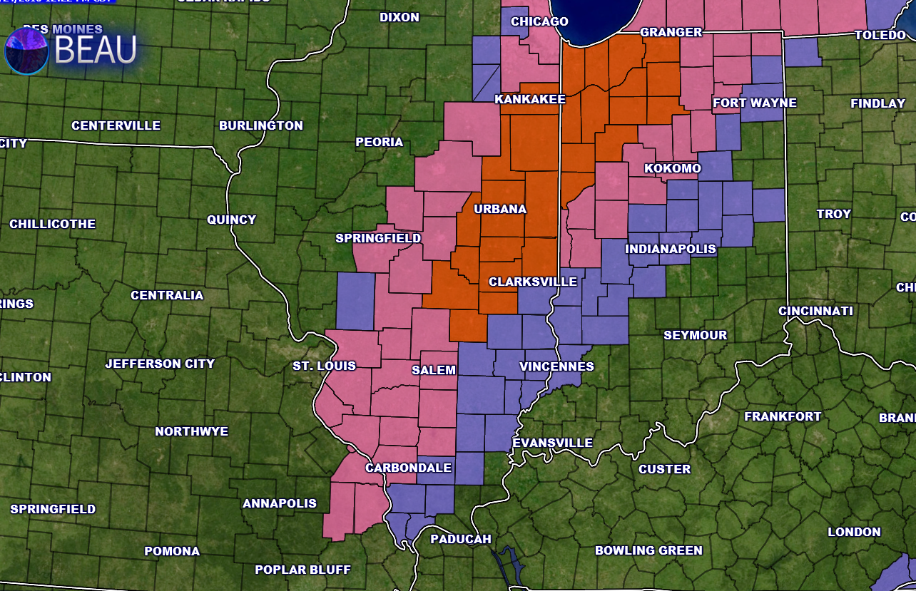
I was thinking blizzard conditions would be possible where the wind and snow combined. Blizzard warnings were issued for parts of Illinois and Indiana. Blizzard warnings are in red.
The pink and blue zone expire on Tuesday afternoon.
Overall, the storm behaved about as expected. As is usually the case, some areas picked up less snow than anticipated. But, many counties verified on the low end of the totals.
With temperatures above freezing the snow has been melting. Slushy event. Marginal event. And, it had a very high bust potential. All in all I was satisfied with the outcome of the forecast. Was not sure how much snow would fall. Tricky system.
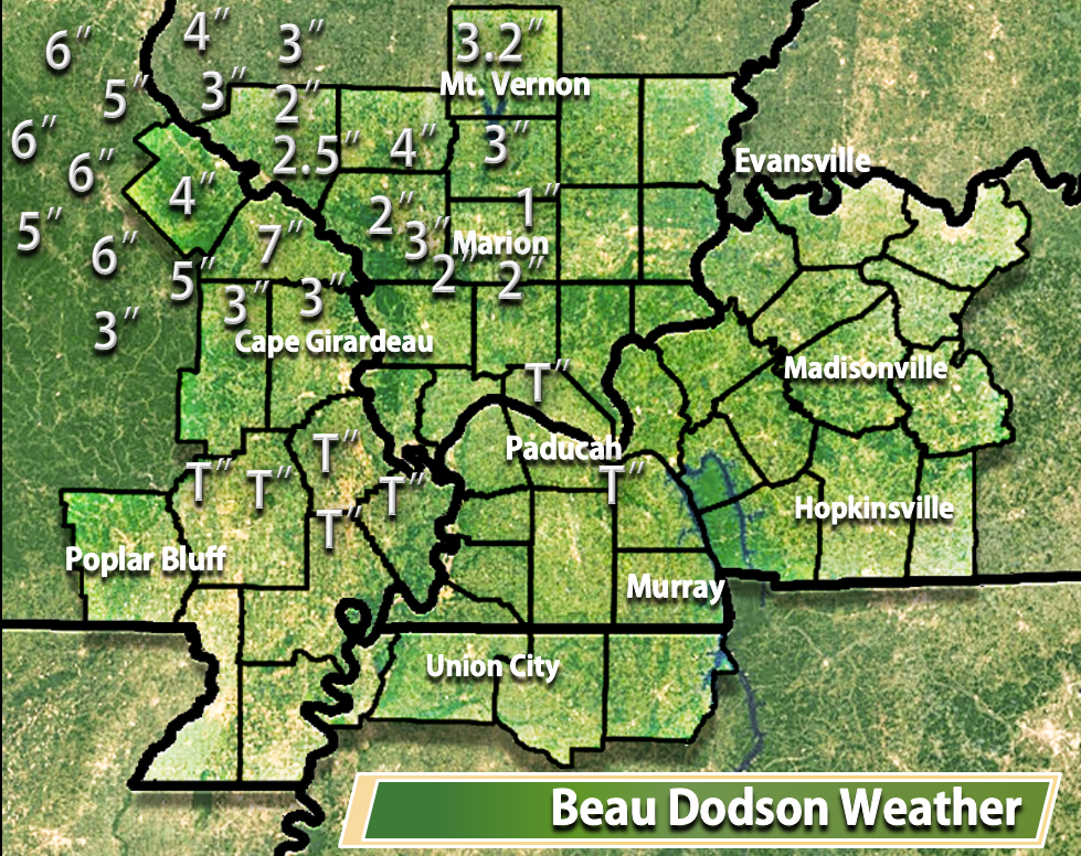
Models showed 10-18″ of snow for southeast Missouri and southern Illinois. Just one example of why you need human forecasters.
Here is the latest map of reported accumulations. This is what fell.
Calmer weather for the next few days. We will warm up by Friday into the weekend. Likely will see 50s by Friday. That is the good news.
A few snow showers still possible Wednesday night and Thursday. But, nothing of significance.

A few snow showers possible Wednesday night and Thursday.

Wednesday Night – Snow comes to an end. Perhaps a few remaining flurries or snow showers.
Thursday – Flurry or snow shower possible.
Friday – No snow or ice anticipated.
Saturday – No snow or ice anticipated.
Sunday – No snow or ice anticipated.

No major changes in the forecast.

Monitor the potential for dense fog Wednesday night/Thursday morning.


How much precipitation should we expect over the next few days?

Can we expect severe thunderstorms over the next 24 to 48 hours? Remember that a severe thunderstorm is defined as a thunderstorm that produces 58 mph winds or higher, quarter size hail or larger, and/or a tornado.
The thunderstorm threat level will be a ONE on Tuesday (mostly Tuesday night). Lightning possible.
The thunderstorm threat level will be a ONE on Wednesday. Lightning possible.

Here is the official 6-10 day and 8-14 day temperature and precipitation outlook. Check the date stamp at the top of each image (so you understand the time frame).
The forecast maps below are issued by the Weather Prediction Center (NOAA).


The latest 8-14 day temperature and precipitation outlook. Note the dates are at the top of the image. These maps DO NOT tell you how high or low temperatures or precipitation will be. They simply give you the probability as to whether temperatures or precipitation will be above or below normal.


Here are the current river stage forecasts. You can click your state and then the dot for your location. It will bring up the full forecast and hydrograph.
Click Here For River Stage Forecasts…

Who do you trust for your weather information and who holds them accountable?
I have studied weather in our region since the late 1970’s. I have 37 years of experience in observing our regions weather patterns. My degree is in Broadcast Meteorology from Mississippi State University and an Associate of Science (AS). I am currently working on my Bachelor’s Degree in Geoscience.
My resume includes:
Member of the American Meteorological Society.
NOAA Weather-Ready Nation Ambassador.
Meteorologist for McCracken County Emergency Management. I served from 2005 through 2015.
I own and operate the Southern Illinois Weather Observatory.
Recipient of the Mark Trail Award, WPSD Six Who Make A Difference Award, Kentucky Colonel, and the Caesar J. Fiamma” Award from the American Red Cross.
In 2009 I was presented with the Kentucky Office of Highway Safety Award.
Recognized by the Kentucky House of Representatives for my service to the State of Kentucky leading up to several winter storms and severe weather outbreaks.
I am also President of the Shadow Angel Foundation which serves portions of western Kentucky and southern Illinois.
There is a lot of noise on the internet. A lot of weather maps are posted without explanation. Over time you should learn who to trust for your weather information.
My forecast philosophy is simple and straight forward.
- Communicate in simple terms
- To be as accurate as possible within a reasonable time frame before an event
- Interact with you on Twitter, Facebook, and the blog
- Minimize the “hype” that you might see on television or through other weather sources
- Push you towards utilizing wall-to-wall LOCAL TV coverage during severe weather events
I am a recipient of the Mark Trail Award, WPSD Six Who Make A Difference Award, Kentucky Colonel, and the Caesar J. Fiamma” Award from the American Red Cross. In 2009 I was presented with the Kentucky Office of Highway Safety Award. I was recognized by the Kentucky House of Representatives for my service to the State of Kentucky leading up to several winter storms and severe weather outbreaks.
If you click on the image below you can read the Kentucky House of Representatives Resolution.

Many of my graphics are from www.weatherbell.com – a great resource for weather data, model data, and more


You can sign up for my AWARE email by clicking here I typically send out AWARE emails before severe weather, winter storms, or other active weather situations. I do not email watches or warnings. The emails are a basic “heads up” concerning incoming weather conditions.