We have some great sponsors for the Weather Talk Blog. Please let our sponsors know that you appreciate their support for the Weather Talk Blog.
Milner and Orr Funeral Home and Cremation Services located in Paducah, Kentucky and three other western Kentucky towns – at Milner and Orr they believe in families helping families. You can find Milner and Orr on Facebook, as well.
![]()
.

For all of your families eye care needs. Visit their web-site here. Or, you can also visit their Facebook page.
.

Best at Enabling Body Shop Profitability since 1996. Located In Paducah Kentucky and Evansville Indiana; serving all customers in between. They provide Customer Service, along with all the tools necessary for body shops to remain educated and competitive. Click the logo above for their main web-site. You can find McClintock Preferred Finishes on Facebook, as well
.

Duck/goose decoys? Game calls? Optics? We have you covered! Click the logo above or visit Final Flight on Facebook, as well.
I have launched the new weather texting service! I could use your help. Be sure and sign up and fully support all of the weather data you see each day.
This is a monthly subscription service. Supporting this helps support everything else. The cost is $3 a month for one phone, $5 a month for three phones, and $10 a month for seven phones.
For more information visit BeauDodsonWeather.com
Or directly sign up at Weathertalk.com


This forecast update covers far southern Illinois, far southeast Missouri, and far western Kentucky. See the coverage map on the right side of the blog.
Remember that weather evolves. Check back frequently for updates, especially during active weather.

Weather Radars
WEATHER RADAR PAGE – Click here
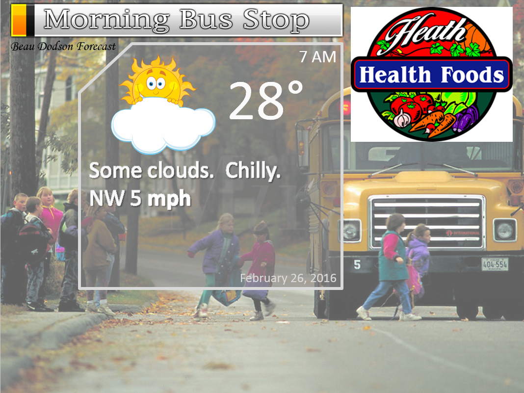
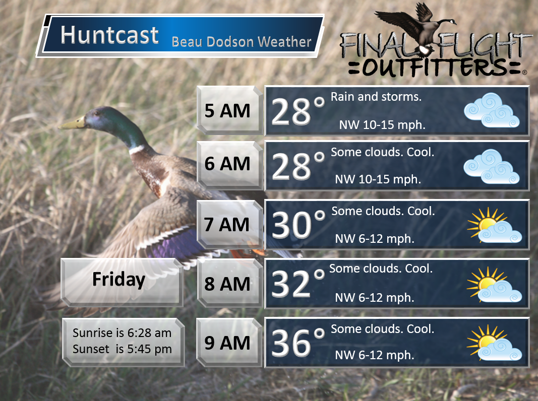
Thursday Night – Cloudy early and then some clearing. Cold. Perhaps some patchy fog.
Temperatures: Lows in the 25-30 degree range.
Winds: West/northwest winds at 10-15 mph.
What is the chance for precipitation? 0%
Coverage of precipitation? None
My confidence in this part of the forecast verifying is High
Should I be concerned about snow or ice? No
Should I cancel my outdoor plans? No
Is severe weather expected? No.
What impact is expected? None
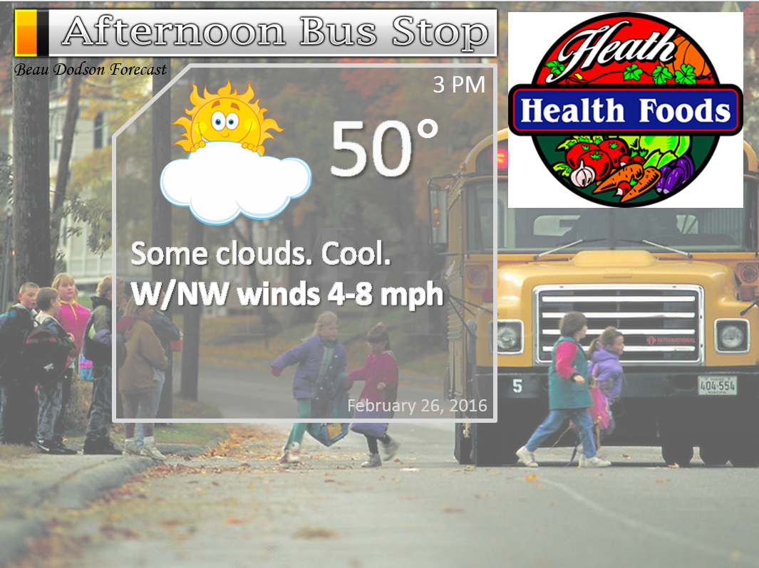
Friday – Partly sunny. Not as cold.
Temperatures: Highs temperatures will mostly be in the middle 40s.
Winds: West/northwest winds at 6-12 mph.
What is the chance for precipitation? 0%
Coverage of precipitation? None
My confidence in this part of the forecast verifying is High
Should I be concerned about snow or ice? No
Should I cancel my outdoor plans? No
Is severe weather expected? No
What impact is expected? None expected.
Friday Night – A few clouds. Cool. Patchy fog possible.
Temperatures: Lows in the 30-35 degree range.
Winds: Light winds and variable direction.
What is the chance for precipitation? 0%
Coverage of precipitation? None
My confidence in this part of the forecast verifying is High
Should I be concerned about snow or ice? No
Should I cancel my outdoor plans? No
Is severe weather expected? No.
What impact is expected? None
Saturday – Partly sunny. Milder.
Temperatures: Highs temperatures 54-58 degree range. We could touch 60 over southeast Missouri.
Winds: Southwest winds at 6-12 mph.
What is the chance for precipitation? 0%
Coverage of precipitation? None
My confidence in this part of the forecast verifying is High
Should I be concerned about snow or ice? No
Should I cancel my outdoor plans? No
Is severe weather expected? No
What impact is expected? None expected.
Saturday Night – A few clouds.
Temperatures: Lows in the 40-45 degree range.
Winds: Southwest winds at 6-12 mph.
What is the chance for precipitation? 0%
Coverage of precipitation? None
My confidence in this part of the forecast verifying is Medium
Should I be concerned about snow or ice? No
Should I cancel my outdoor plans? No
Is severe weather expected? No.
What impact is expected? None
Sunday – Partly sunny and breezy. Mild. Maybe a scattered afternoon shower.
Temperatures: Highs temperatures 64-68 degree range.
Winds: Southwest winds at 15-30 mph. Gusty.
What is the chance for precipitation? 20%
Coverage of precipitation? None
My confidence in this part of the forecast verifying is High
Should I be concerned about snow or ice? No
Should I cancel my outdoor plans? No
Is severe weather expected? No
What impact is expected? Gusty winds for boaters.
Sunday Night – Increasing clouds. Cool. A chance for spotty showers.
Temperatures: Lows in the 42-44 degree range.
Winds: Southwest winds at 6-12 mph. Gusts to 20 mph. Winds may shift to the west late.
What is the chance for precipitation? 20%
Coverage of precipitation? Scattered
My confidence in this part of the forecast verifying is Medium
Should I be concerned about snow or ice? No
Should I cancel my outdoor plans? No
Is severe weather expected? No.
What impact is expected? Maybe some wet roadways.
Monday – Partly sunny and breezy. Mild.
Temperatures: Highs temperatures 64-68 degree range.
Winds: North winds at 5 mph.
What is the chance for precipitation? 0%
Coverage of precipitation? None
My confidence in this part of the forecast verifying is High
Should I be concerned about snow or ice? No
Should I cancel my outdoor plans? No
Is severe weather expected? No
What impact is expected? None expected.
Monday Night – Partly cloudy.
Temperatures: Lows in the 42-44 degree range.
Winds: South winds 5-10 mph.
What is the chance for precipitation? 10%
Coverage of precipitation? Most likely no precipitation. Will be monitoring a new system coming in from the west.
My confidence in this part of the forecast verifying is Medium
Should I be concerned about snow or ice? No
Should I cancel my outdoor plans? No
Is severe weather expected? No.
What impact is expected? None
Tuesday – Quite a few clouds. A shower or thunderstorm possible.
Temperatures: Highs temperatures may vary across the region. This will depend on the track of the area of low pressure. Goes south and we will be colder. Well north and we will end up mild. Highs in the upper 50s to middle 60s.
Winds: Southeast winds at 10-15 mph.
What is the chance for precipitation? 30% (but, may change)
Coverage of precipitation? Scattered
My confidence in this part of the forecast verifying is Low
Should I be concerned about snow or ice? No
Should I cancel my outdoor plans? No
Is severe weather expected? No
What impact is expected? Wet roadways possible.
Rain chances will be with us on Tuesday night and perhaps Wednesday morning. This will depend on the speed of the next system moving into the region.

Heath Health Foods is a locally owned and operated retail health and wellness store. Since opening in February 2006; the store has continued to grow as a ministry with an expanding inventory which also offers wellness appointments and services along with educational opportunities. Visit Heath Health Foods on Facebook!


Don’t forget to check out the Southern Illinois Weather Observatory web-site for weather maps, tower cams, scanner feeds, radars, and much more! Click here

An explanation of what is happening in the atmosphere over the coming days…
Highlights
1. Spring weekend on tap!
2. Windy on Sunday
3. Small chance for showers Sunday afternoon/night.
4. Stronger storm system next Monday night into Tuesday night
We had some spotty snow and sleet showers around on Thursday. About what was expected. A few rain showers, as well. Nothing of significance.
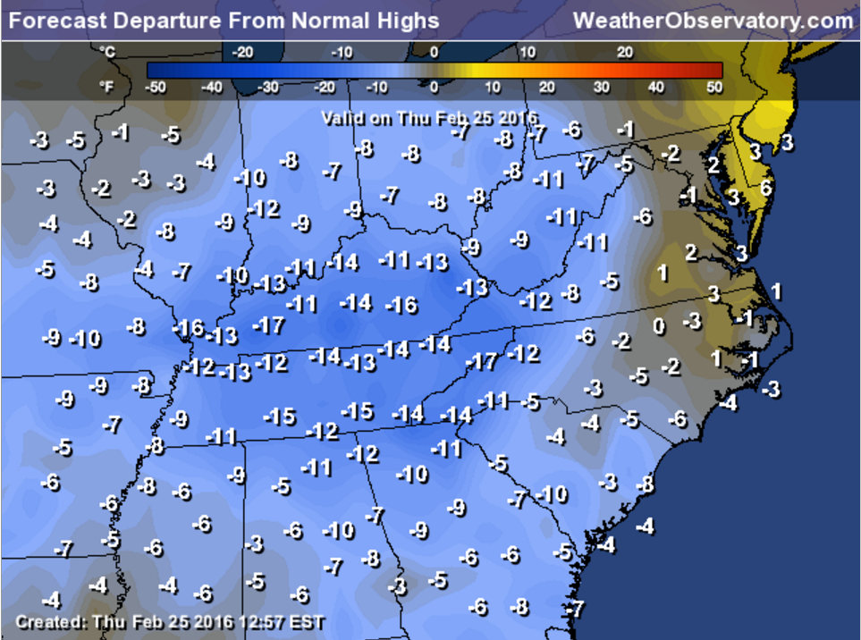
Temperatures on Thursday were WELL below normal. Normal highs are in the 50s for this time of the year. We only reached the 30s and lower 40s.
Here is the temperature anomaly map. As you can see, we were way below normal.
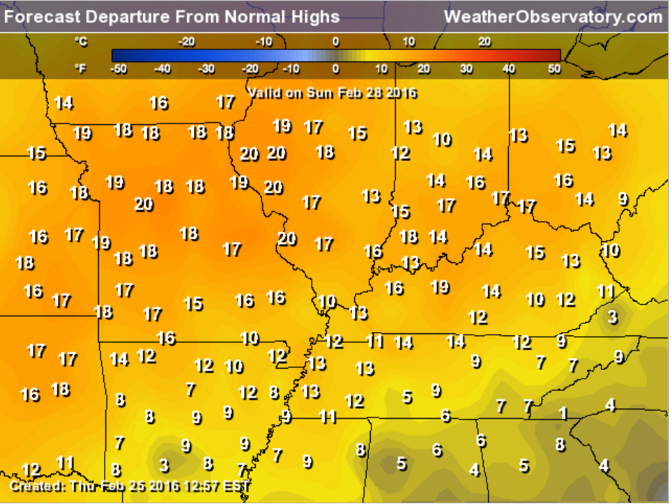
The big weather story will be spring like temperatures by Saturday and especially Sunday.
Check out the temperature anomalies on Sunday compared to the above map. Normal high temperatures are around 50-52 degrees. Sunday will deliver widespread 60s. Way above normal.
Friday will be milder than Thursday. Saturday will be milder than Friday. Sunday will be the pick day of the weekend, but it will be windy.
If you are boating on Sunday then expect winds of 15-30 mph and higher gusts are possible.
NAM guidance is showing some gusts into the 40s on Sunday morning/afternoon. I do expected quite a few gusts into the 30s. And, it could be a bit higher, as well.
A cold front will move through the region on Sunday afternoon and evening. A few showers possible along the front. Spotty.
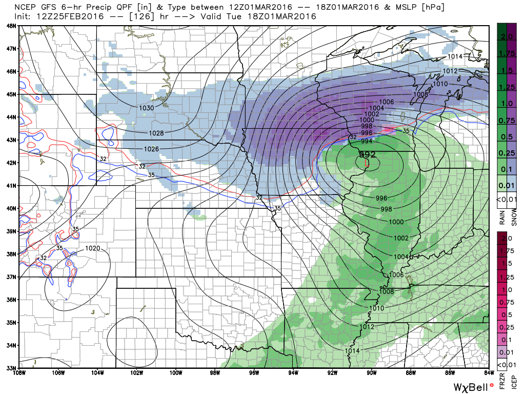
A stronger storm system arrives on Monday night into Tuesday night.
The storm track will be key to sensible weather in our region. If the area of low pressure moves to our north then thunderstorms will be possible.
The GFS takes the low well north of our region. Thus, some thunderstorms are possible.
Needless to say, I will be monitoring trends. Either way, expect some rain chances by Monday night – Tuesday night. Will need to work on the exact timing of the system as we move forward.
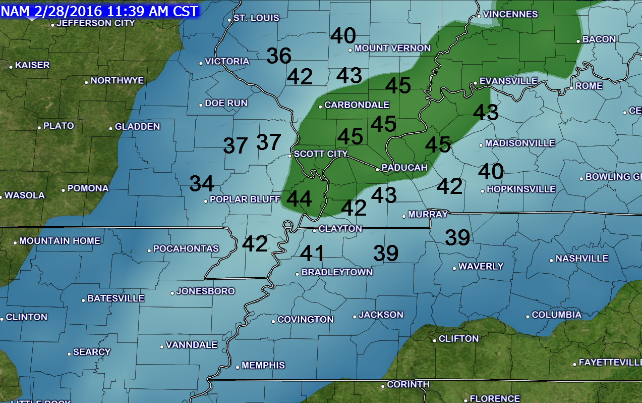
Here is the GFS guidance. See the low way to our north? The red L. That keeps us on the warm side.
Green is rain.

No winter weather of any significance. Small chance for flurry/sleet on Thursday evening.

Friday – No snow or ice anticipated.
Saturday – No snow or ice anticipated.
Sunday – No snow or ice anticipated.
Monday – No snow or ice anticipated.

Updated wind speeds for Sunday. Gusty winds.

No major concerns. Perhaps some patchy fog.
Windy for boaters on Sunday.


How much precipitation should we expect over the next few days?
No rain expected through Sunday morning.
Maybe a few showers Sunday afternoon or night. Light.
Better chance for rainfall on Monday night/Tuesday/Tuesday night.

Can we expect severe thunderstorms over the next 24 to 48 hours? Remember that a severe thunderstorm is defined as a thunderstorm that produces 58 mph winds or higher, quarter size hail or larger, and/or a tornado.
The thunderstorm threat level will be ZERO Friday through Sunday.

Here is the official 6-10 day and 8-14 day temperature and precipitation outlook. Check the date stamp at the top of each image (so you understand the time frame).
The forecast maps below are issued by the Weather Prediction Center (NOAA).


The latest 8-14 day temperature and precipitation outlook. Note the dates are at the top of the image. These maps DO NOT tell you how high or low temperatures or precipitation will be. They simply give you the probability as to whether temperatures or precipitation will be above or below normal.


Here are the current river stage forecasts. You can click your state and then the dot for your location. It will bring up the full forecast and hydrograph.
Click Here For River Stage Forecasts…

Who do you trust for your weather information and who holds them accountable?
I have studied weather in our region since the late 1970’s. I have 37 years of experience in observing our regions weather patterns. My degree is in Broadcast Meteorology from Mississippi State University and an Associate of Science (AS). I am currently working on my Bachelor’s Degree in Geoscience.
My resume includes:
Member of the American Meteorological Society.
NOAA Weather-Ready Nation Ambassador.
Meteorologist for McCracken County Emergency Management. I served from 2005 through 2015.
I own and operate the Southern Illinois Weather Observatory.
Recipient of the Mark Trail Award, WPSD Six Who Make A Difference Award, Kentucky Colonel, and the Caesar J. Fiamma” Award from the American Red Cross.
In 2009 I was presented with the Kentucky Office of Highway Safety Award.
Recognized by the Kentucky House of Representatives for my service to the State of Kentucky leading up to several winter storms and severe weather outbreaks.
I am also President of the Shadow Angel Foundation which serves portions of western Kentucky and southern Illinois.
There is a lot of noise on the internet. A lot of weather maps are posted without explanation. Over time you should learn who to trust for your weather information.
My forecast philosophy is simple and straight forward.
- Communicate in simple terms
- To be as accurate as possible within a reasonable time frame before an event
- Interact with you on Twitter, Facebook, and the blog
- Minimize the “hype” that you might see on television or through other weather sources
- Push you towards utilizing wall-to-wall LOCAL TV coverage during severe weather events
I am a recipient of the Mark Trail Award, WPSD Six Who Make A Difference Award, Kentucky Colonel, and the Caesar J. Fiamma” Award from the American Red Cross. In 2009 I was presented with the Kentucky Office of Highway Safety Award. I was recognized by the Kentucky House of Representatives for my service to the State of Kentucky leading up to several winter storms and severe weather outbreaks.
If you click on the image below you can read the Kentucky House of Representatives Resolution.

Many of my graphics are from www.weatherbell.com – a great resource for weather data, model data, and more


You can sign up for my AWARE email by clicking here I typically send out AWARE emails before severe weather, winter storms, or other active weather situations. I do not email watches or warnings. The emails are a basic “heads up” concerning incoming weather conditions.