We have some great sponsors for the Weather Talk Blog. Please let our sponsors know that you appreciate their support for the Weather Talk Blog.
Milner and Orr Funeral Home and Cremation Services located in Paducah, Kentucky and three other western Kentucky towns – at Milner and Orr they believe in families helping families. You can find Milner and Orr on Facebook, as well.
![]()
.

For all of your families eye care needs. Visit their web-site here. Or, you can also visit their Facebook page.
.

Best at Enabling Body Shop Profitability since 1996. Located In Paducah Kentucky and Evansville Indiana; serving all customers in between. They provide Customer Service, along with all the tools necessary for body shops to remain educated and competitive. Click the logo above for their main web-site. You can find McClintock Preferred Finishes on Facebook, as well
.

Duck/goose decoys? Game calls? Optics? We have you covered! Click the logo above or visit Final Flight on Facebook, as well.
.
I have launched the new weather texting service! I could use your help. Be sure and sign up and fully support all of the weather data you see each day.
This is a monthly subscription service. Supporting this helps support everything else. The cost is $3 a month for one phone, $5 a month for three phones, and $10 a month for seven phones.
For more information visit BeauDodsonWeather.com
Or directly sign up at Weathertalk.com


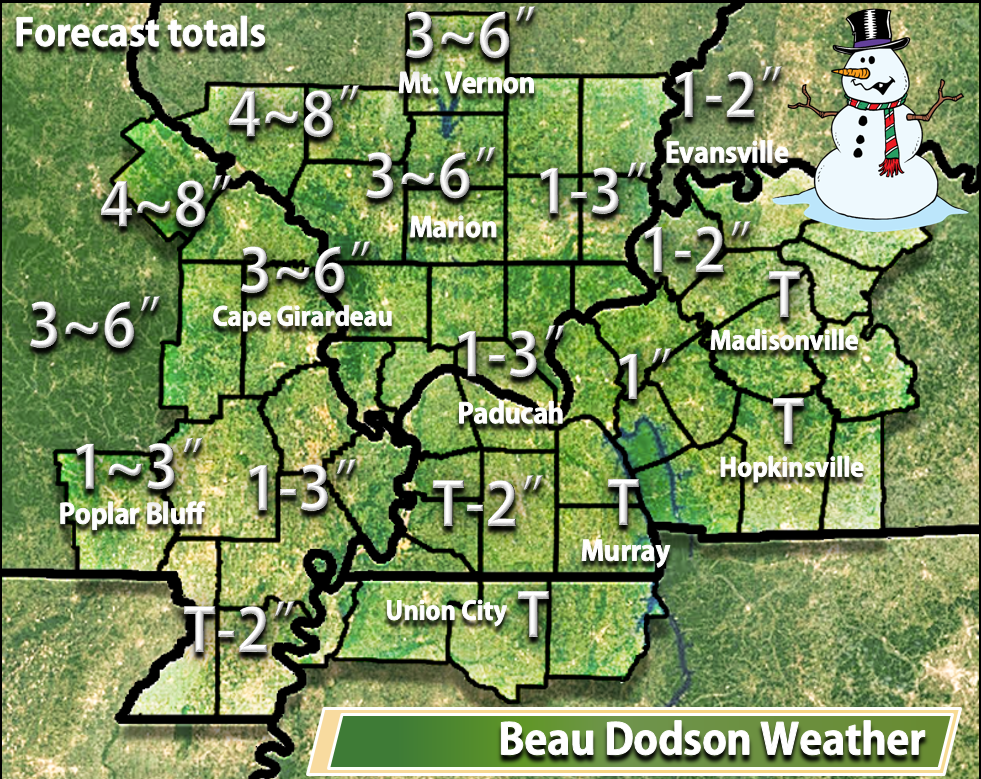
This forecast update covers far southern Illinois, far southeast Missouri, and far western Kentucky. See the coverage map on the right side of the blog.
Remember that weather evolves. Check back frequently for updates, especially during active weather.

Weather Radars
WEATHER RADAR PAGE – Click here —
Wide range of weather possible over our region on Tuesday night and Wednesday. Snow is more likely over our far western and northwest counties of southeast Missouri and southern Illinois. See full discussion further down in this forecast update. Whether western Kentucky and northwest Tennessee experience accumulating snow is questionable. Keep this in mind. Low confidence forecast.
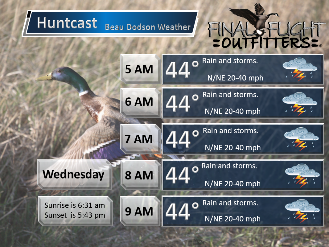
Wednesday Morning Update
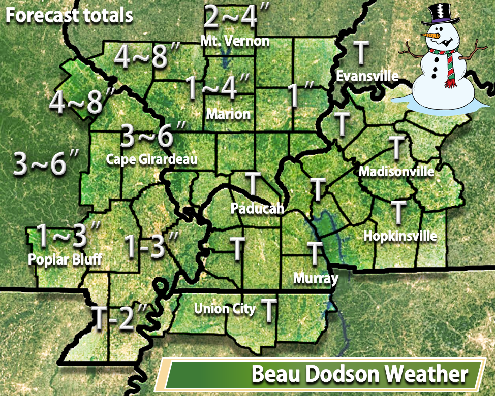
Latest forecast graphic for expected totals. Low confidence, overall. Wet snow and high winds.
Lower confidence for western Kentucky vs areas to the north and west. Overall, everything is coming together about as expected.
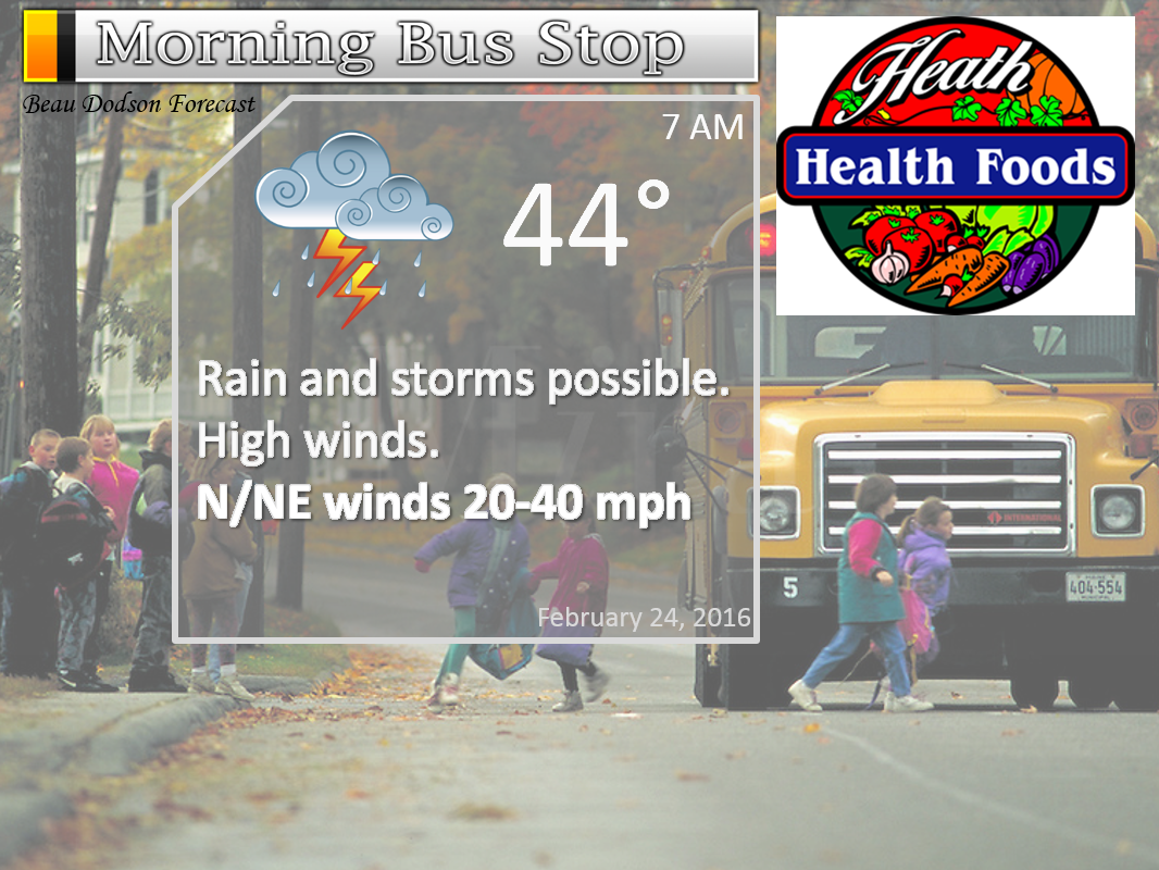
Tuesday Night – High wind alert for late tonight. Cloudy. Rain likely. Thunderstorms possible late. Windy. Locally heavy rain possible. We will have to monitor the potential for frozen precipitation over parts of Missouri and Illinois after 4 am.
Temperatures: Lows in the upper 30s to lower 40s. Rising temperatures possible late at night over Kentucky and Tennessee. Turning colder over our northwest counties.
Winds: North winds at 10-30 mph. Gusts above 45 mph possible.
What is the chance for precipitation? 80%
Coverage of precipitation? Widespread
My confidence in this part of the forecast verifying is High
Should I be concerned about snow or ice? Unlikely for most of us. Will be watching far western and northwestern counties in southeast Missouri and southwest Illinois. See graphics below.
Should I cancel my outdoor plans? I would consider a backup plan
Is severe weather expected? Not at this time.
What impact is expected? Wet roadways. High winds. Perhaps some accumulating wet snow over parts of Missouri and Illinois. See full discussion further down in this forecast update.
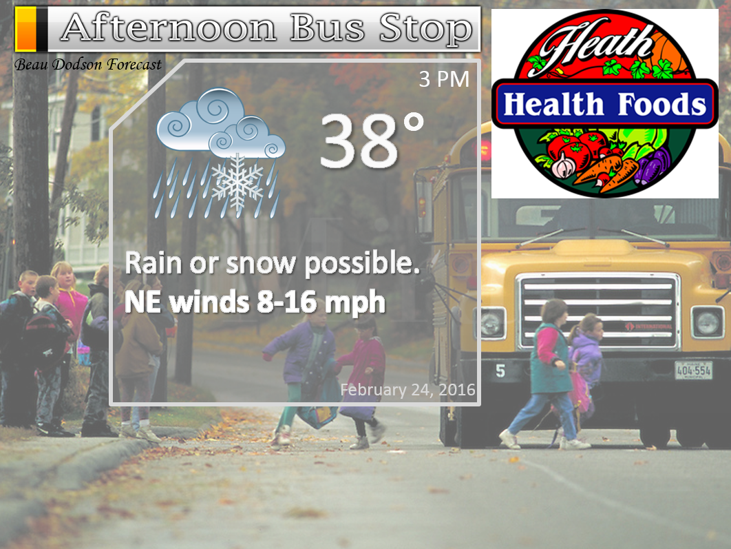
Wednesday – High wind alert for Wednesday. Showers and thunderstorms likely. Strong winds likely. Turning colder over our western counties of southeast Missouri and southwest Illinois early in the day. Then, turning colder from west to east through the afternoon hours. Wet snow possible over southeast Missouri and southern Illinois. Rain may mix with or change to snow area-wide as the system pulls away on Wednesday morning into Wednesday evening. Several inches of wet snow accumulation possible in a band across parts of southeast Missouri and southern Illinois. Can’t rule out accumulation over parts of the rest of the area, as well. Very low confidence on the accumulation. High winds combined with snow could cause reduced visibility.
Temperatures: Highs temperatures will vary greatly. Possibly into the 60s over our southern and southeastern counties and in the middle 30s over parts of southeast Missouri and northwest parts of southern Illinois.
Winds: North and northwest at 20-40 mph. Higher gusts likely. Winds may turn out of the south over parts of western Kentucky and Tennessee on Wednesday morning and then turn more westerly during the afternoon hours.
What is the chance for precipitation? 70%
Coverage of precipitation? Widespread
My confidence in this part of the forecast verifying is Medium
Should I be concerned about snow or ice? Parts of the area could experience wet snow.
Should I cancel my outdoor plans? At this time, rain appears likely
Is severe weather expected? Unlikely, but I will be monitoring south central Kentucky.
What impact is expected? Windy. Wet roadways. Lightning possible. Will need to monitor for wintry precipitation at least over our western and northwestern counties of southeast Missouri and parts of southern Illinois. And, this could spread eastward during the day. Temperatures will be marginal for this snow event, but heavy wet snow might overcome that obstacle.
Wednesday Night – Cloudy. Turning colder. Any rain showers or snow showers will be coming to an end.
Temperatures: Lows in the 32 to 38 degree range.
Winds: West/northwest winds at 10-15 mph. Gusty.
What is the chance for precipitation? 60% early.
Coverage of precipitation? Scattered
My confidence in this part of the forecast verifying is Low
Should I be concerned about snow or ice? Monitor updates
Should I cancel my outdoor plans? I would consider a backup plan
Is severe weather expected? No.
What impact is expected? Wet roadways. Maybe some wet snow.
Thursday – Some clouds. Small chance for a flurry.
Temperatures: Highs temperatures will mostly be in the 40s.
Winds: North and northwest at 5-10 mph.
What is the chance for precipitation? 10%
Coverage of precipitation? None
My confidence in this part of the forecast verifying is Medium
Should I be concerned about snow or ice? Unlikely
Should I cancel my outdoor plans? No
Is severe weather expected? No
What impact is expected? None expected. If wet snow fell on Wednesday then parts of the area may still be dealing with that.

Don’t forget to check out the Southern Illinois Weather Observatory web-site for weather maps, tower cams, scanner feeds, radars, and much more! Click here

An explanation of what is happening in the atmosphere over the coming days…
Highlights
1. Strong winds develop late tonight and on Wednesday
2. Rain, some locally heavy, will spread over the area tonight into Wednesday.
3. Wet snow on the west and northwest side of the system. Some could be heavy.
4. Thunderstorms possible over the area. Lightning being the main concern.
A complex weather set-up is moving into our region.
A high wind alert late tonight into early Wednesday afternoon.
A powerful late winter storm will push out of Texas into Louisiana and Arkansas on Tuesday night. The low will deepen from 1000 mb over eastern Texas to below 990 mb as it enters Tennessee. Near record low barometer readings are possible with this event. Unusual, to say the least.
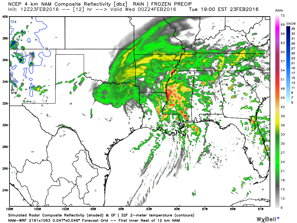
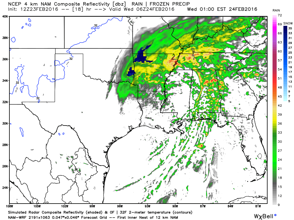
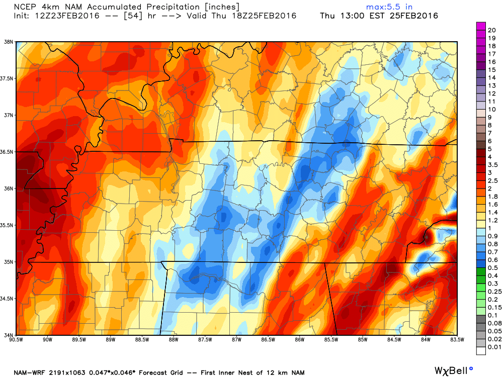
As of 2 PM on Tuesday: Widespread rain is already covering a large chunk of real estate from Oklahoma and Texas into the lower Mississippi River Valley. This rain will spread north and east on Tuesday night and Wednesday morning.
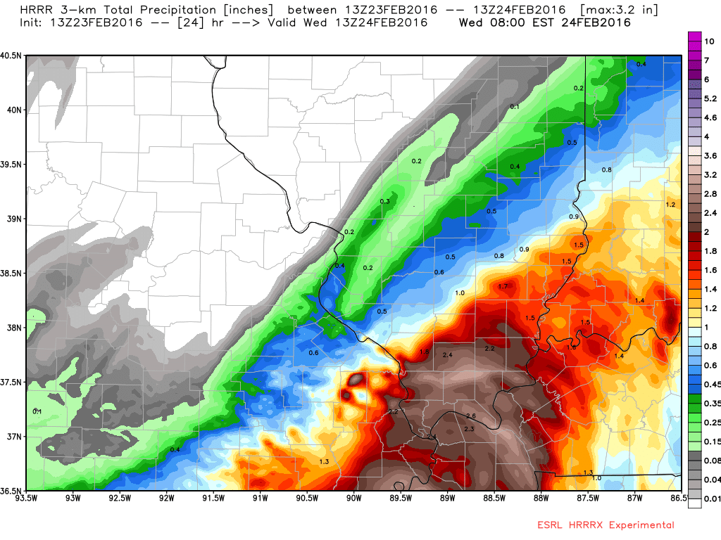
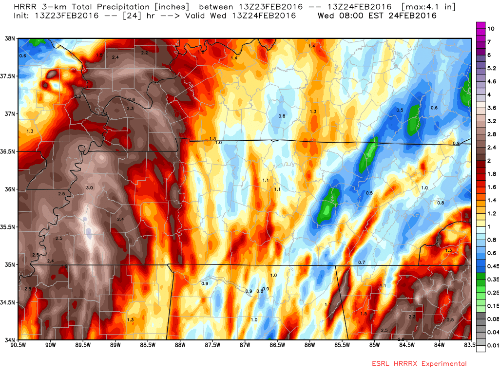
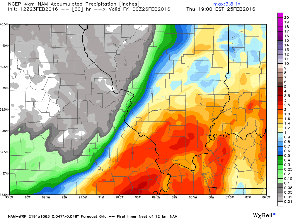
Some of the rain could be heavy at times late Tuesday night and Wednesday. Widespread 0.75″-1.25″ of rain is anticipated. With pockets of 1.25″-2.25″ possible.
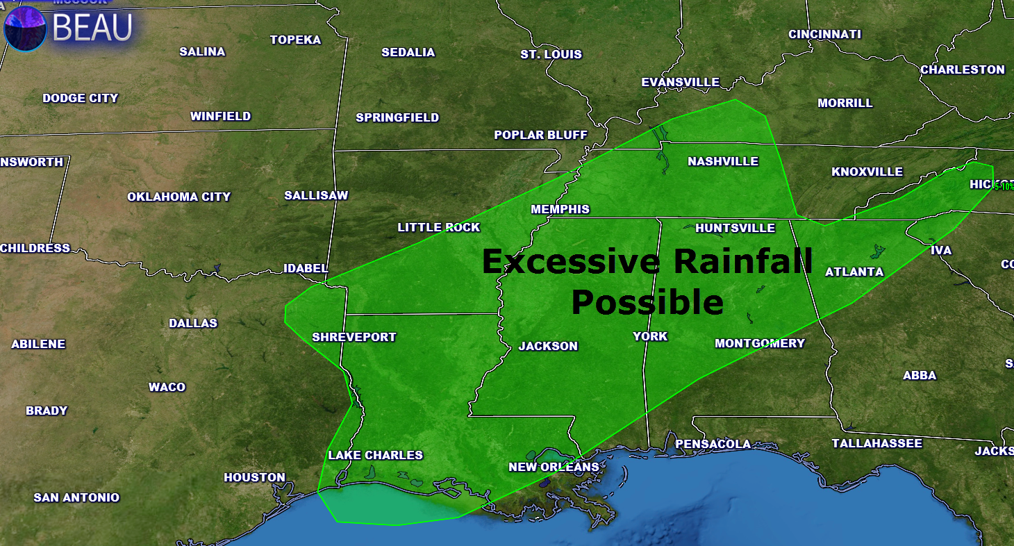
The WPC has posted an excessive rainfall outlook. This does cover parts of our region. Basically this means that rains could exceed flash flood levels. There is a slight risk of this happening. Some ditches and streams could have sharp rises of water. Especially in the green zone.
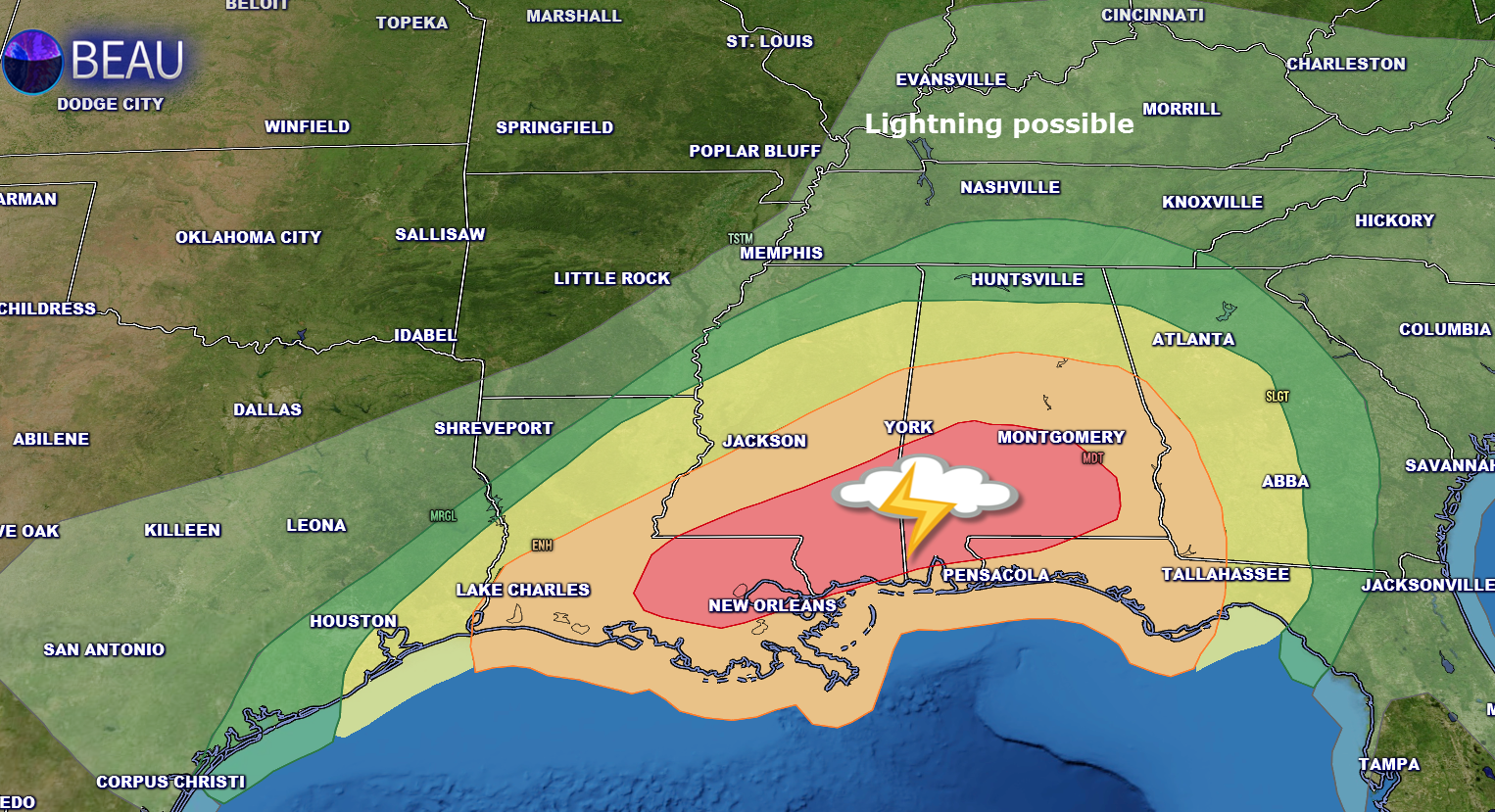
Another aspect of this system will be a severe weather outbreak. Here is the severe weather outlook for Tuesday afternoon and night. Our region is marked for non-severe storms. Lightning is the main concern locally. Further south, however, tornadoes and severe storms are likely. This would extend from Louisiana into Georgia.
Wind is going to be a problem in our region. This is a deep area of low pressure. The deeper the low the more likely for high winds. A tight pressure gradient will develop tonight and on Wednesday morning. Tight pressure gradients are responsible for high winds.
See yesterday’s post for some map examples of pressure gradients.
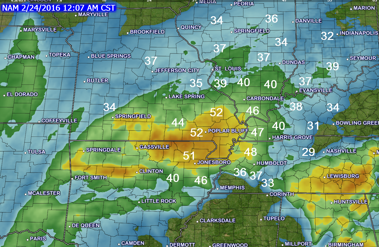
Here is the wind gust forecast animation. This is from the WRF model guidance. It might be a little high on the numbers, but I do expect widespread 30-45 mph wind gusts. And, winds may gust above 50 mph at times. This could bring down tree limbs, trees, and power lines. This is especially true for parts of southeast Missouri and southern Illinois. The highest winds are forecast to be over Missouri and Illinois.
Gusty winds late tonight and on Wednesday.
Here are some still shots for the wind gusts forecast.
This first image is for 12 am Wednesday
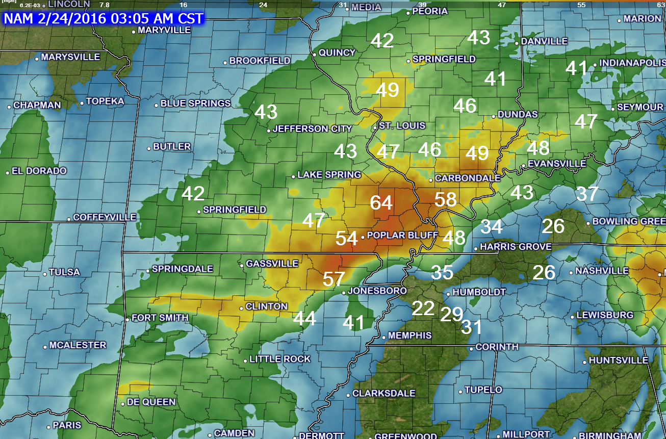
Here is the 3 am map. We will have to see if the 60 mph gusts verify. I do expect gusts above 50 mph.
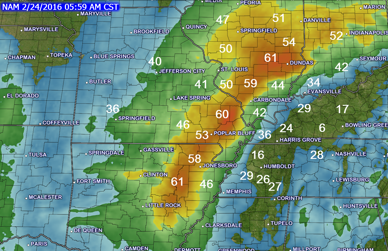
6 AM wind gust map. We will have to see if the 60 mph gusts verify. I do expect gusts above 50 mph.
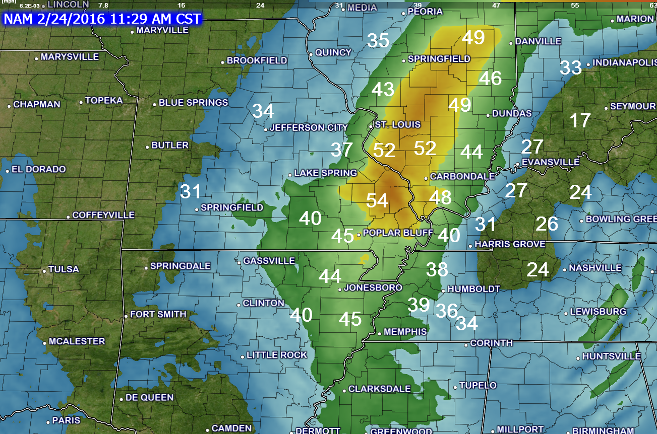
12 PM wind gust map
Another aspect of this system will be wet snow.
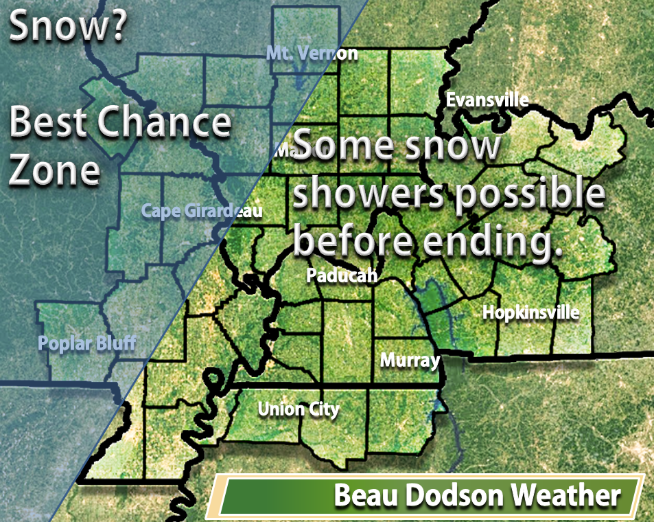
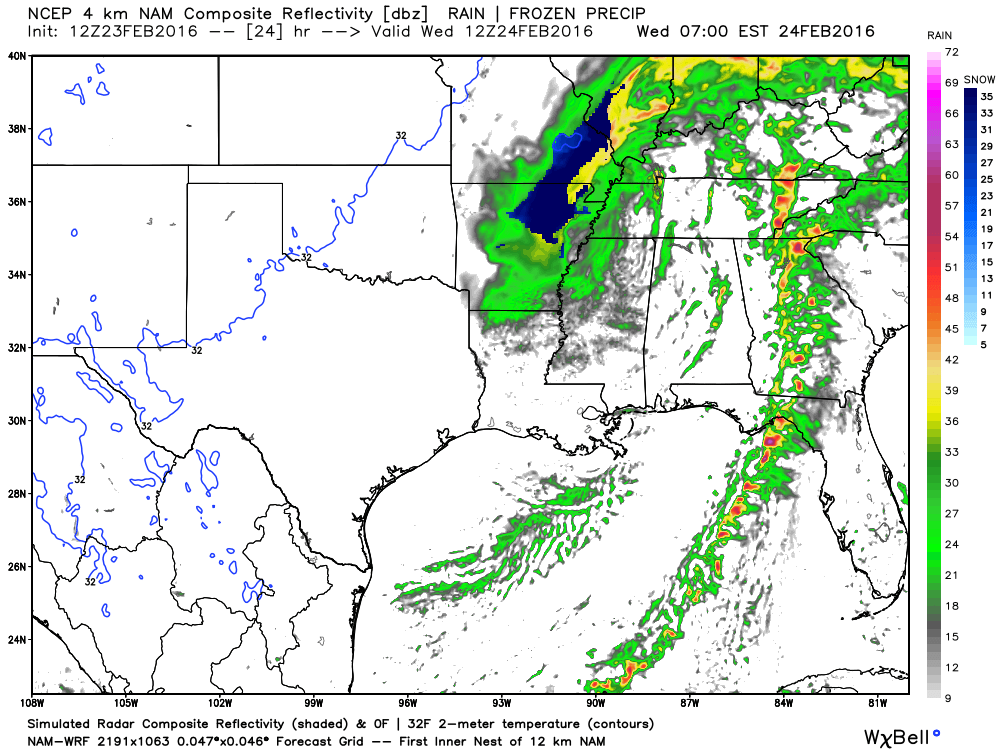
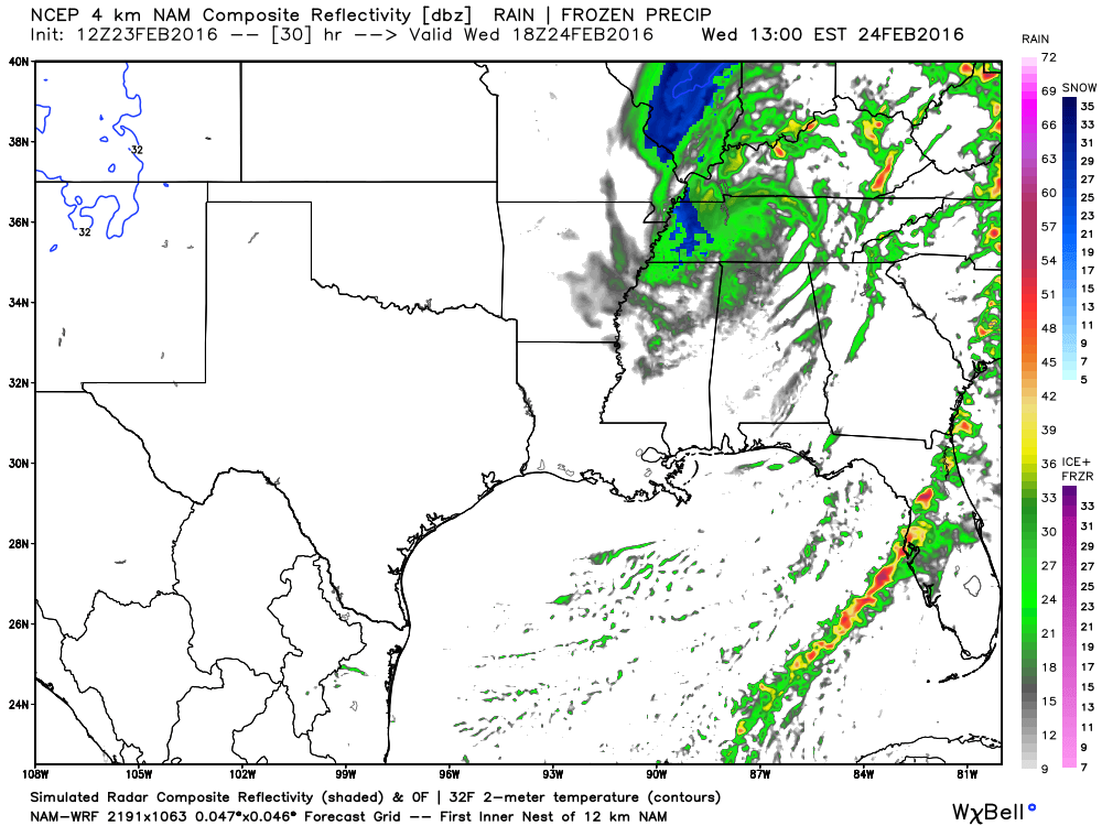
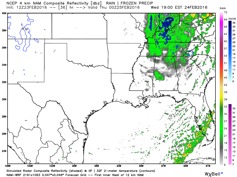

Some snowflakes could occur just about anywhere in the region as the system pulls away on Wednesday. But, accumulating snow appears unlikely, at this time, for far southern Illinois, far southeast Missouri, western Kentucky, and northwest Tennessee. However, any shift in the storms path could cause adjustments in the snow forecast.
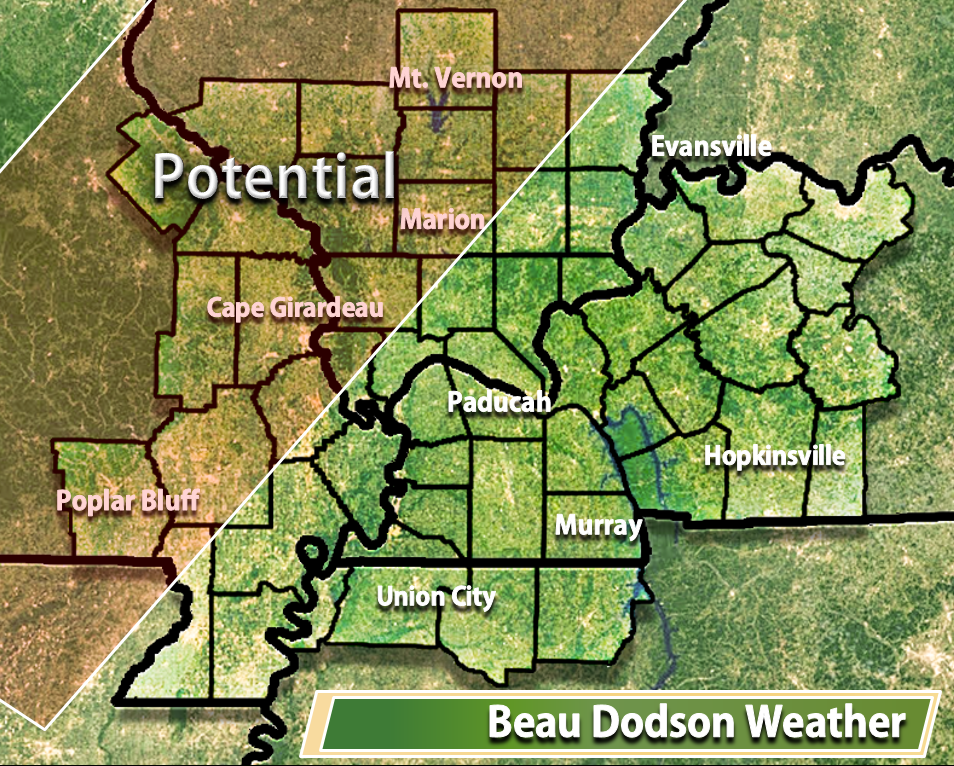
Low confidence on what happens in far southern Illinois and western Kentucky. Monitor updates. Changes are possible on snowfall accumulation maps.

Tuesday night – Wet snow could develop over south central Missouri after 3 am.
Wednesday – Rain may change to wet snow over southeast Missouri and southern Illinois. And, snowflakes might occur in western Kentucky and northwest Tennessee, as well. Accumulations are least likely over Kentucky and Tennessee. But, some wet snow may accumulate over parts of southeast Missouri and southern Illinois. However, any shift in the storms path could cause adjustments in the snow forecast.
Thursday – No snow or ice anticipated. Maybe a flurry.
Friday – No snow or ice anticipated.
Saturday/Sunday – No snow or ice anticipated.

No major changes in the forecast.

Strong winds on Tuesday night and Wednesday. Winds could gust above 45 mph.
Wet snow is possible on Tuesday night (late) and Wednesday over our western and northern counties. See the map in the discussion above.
Whether snow spreads south and east into far southern Illinois and western Kentucky/Tennessee is uncertain.


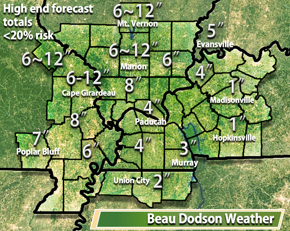
The wild card in the forecast will be wet snow. How much snow will fall over southeast Missouri into southern Illinois. Bust potential is high with this one. Expect a band of 3-6″ of snow. But, confidence is very low. There are a number of negative factors that will influence this snow event. We will see how it goes.
Wild card is also Kentucky and Tennessee. Will the rain change to wet snow in these areas, as well? It is possible, but confidence is even lower for those areas.

How much precipitation should we expect over the next few days?
Quite a bit of rain is anticipated in our region on Tuesday night into Wednesday afternoon.

Can we expect severe thunderstorms over the next 24 to 48 hours? Remember that a severe thunderstorm is defined as a thunderstorm that produces 58 mph winds or higher, quarter size hail or larger, and/or a tornado.
The thunderstorm threat level will be a ONE on Tuesday (mostly Tuesday night). Lightning possible.
The thunderstorm threat level will be a ONE on Wednesday. Lightning possible.

Here is the official 6-10 day and 8-14 day temperature and precipitation outlook. Check the date stamp at the top of each image (so you understand the time frame).
The forecast maps below are issued by the Weather Prediction Center (NOAA).


The latest 8-14 day temperature and precipitation outlook. Note the dates are at the top of the image. These maps DO NOT tell you how high or low temperatures or precipitation will be. They simply give you the probability as to whether temperatures or precipitation will be above or below normal.


Here are the current river stage forecasts. You can click your state and then the dot for your location. It will bring up the full forecast and hydrograph.
Click Here For River Stage Forecasts…

Who do you trust for your weather information and who holds them accountable?
I have studied weather in our region since the late 1970’s. I have 37 years of experience in observing our regions weather patterns. My degree is in Broadcast Meteorology from Mississippi State University and an Associate of Science (AS). I am currently working on my Bachelor’s Degree in Geoscience.
My resume includes:
Member of the American Meteorological Society.
NOAA Weather-Ready Nation Ambassador.
Meteorologist for McCracken County Emergency Management. I served from 2005 through 2015.
I own and operate the Southern Illinois Weather Observatory.
Recipient of the Mark Trail Award, WPSD Six Who Make A Difference Award, Kentucky Colonel, and the Caesar J. Fiamma” Award from the American Red Cross.
In 2009 I was presented with the Kentucky Office of Highway Safety Award.
Recognized by the Kentucky House of Representatives for my service to the State of Kentucky leading up to several winter storms and severe weather outbreaks.
I am also President of the Shadow Angel Foundation which serves portions of western Kentucky and southern Illinois.
There is a lot of noise on the internet. A lot of weather maps are posted without explanation. Over time you should learn who to trust for your weather information.
My forecast philosophy is simple and straight forward.
- Communicate in simple terms
- To be as accurate as possible within a reasonable time frame before an event
- Interact with you on Twitter, Facebook, and the blog
- Minimize the “hype” that you might see on television or through other weather sources
- Push you towards utilizing wall-to-wall LOCAL TV coverage during severe weather events
I am a recipient of the Mark Trail Award, WPSD Six Who Make A Difference Award, Kentucky Colonel, and the Caesar J. Fiamma” Award from the American Red Cross. In 2009 I was presented with the Kentucky Office of Highway Safety Award. I was recognized by the Kentucky House of Representatives for my service to the State of Kentucky leading up to several winter storms and severe weather outbreaks.
If you click on the image below you can read the Kentucky House of Representatives Resolution.

Many of my graphics are from www.weatherbell.com – a great resource for weather data, model data, and more


You can sign up for my AWARE email by clicking here I typically send out AWARE emails before severe weather, winter storms, or other active weather situations. I do not email watches or warnings. The emails are a basic “heads up” concerning incoming weather conditions.