We have some great sponsors for the Weather Talk Blog. Please let our sponsors know that you appreciate their support for the Weather Talk Blog.
Milner and Orr Funeral Home and Cremation Services located in Paducah, Kentucky and three other western Kentucky towns – at Milner and Orr they believe in families helping families. You can find Milner and Orr on Facebook, as well.
![]()
.

For all of your families eye care needs. Visit their web-site here. Or, you can also visit their Facebook page.
.

Best at Enabling Body Shop Profitability since 1996. Located In Paducah Kentucky and Evansville Indiana; serving all customers in between. They provide Customer Service, along with all the tools necessary for body shops to remain educated and competitive. Click the logo above for their main web-site. You can find McClintock Preferred Finishes on Facebook, as well
.

Duck/goose decoys? Game calls? Optics? We have you covered! Click the logo above or visit Final Flight on Facebook, as well.
.
I have launched the new weather texting service! I could use your help. Be sure and sign up and fully support all of the weather data you see each day.
This is a monthly subscription service. Supporting this helps support everything else. The cost is $3 a month for one phone, $5 a month for three phones, and $10 a month for seven phones.
For more information visit BeauDodsonWeather.com
Or directly sign up at Weathertalk.com


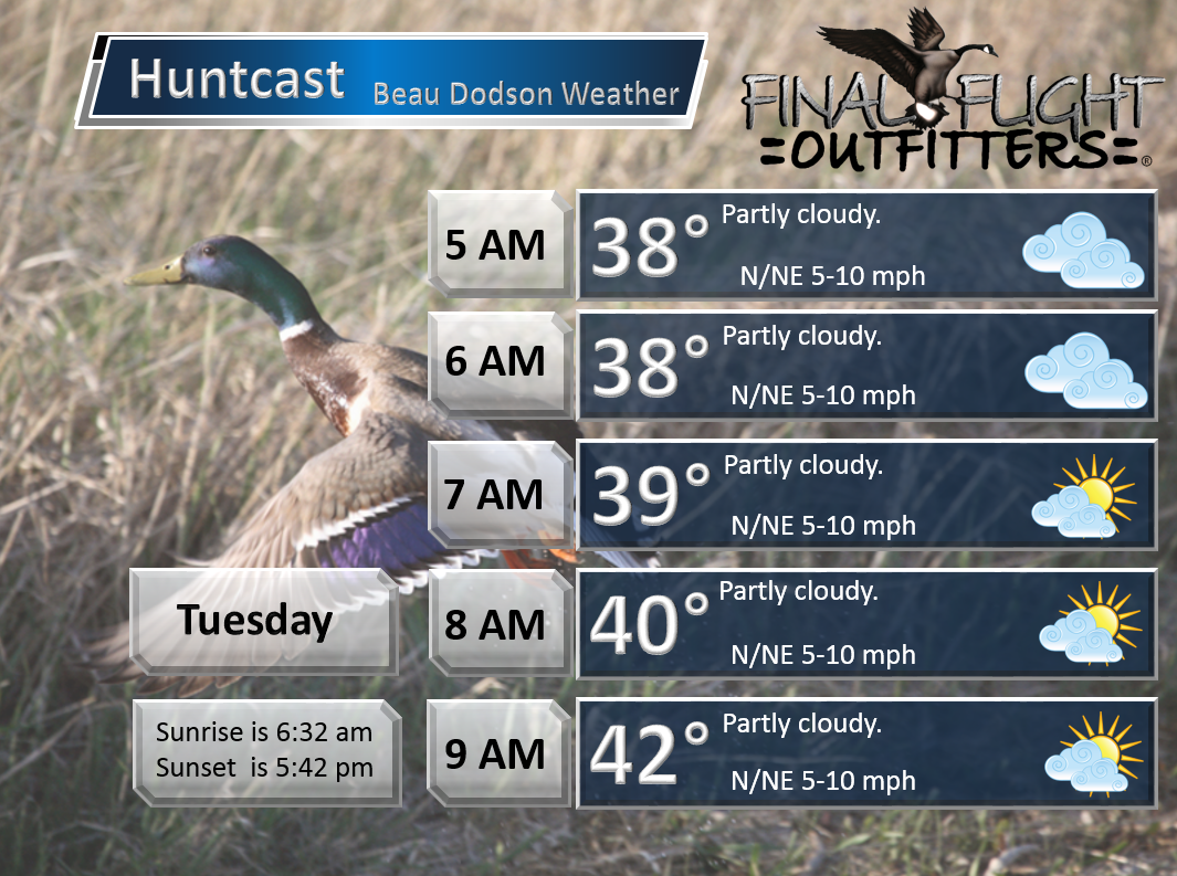
This forecast update covers far southern Illinois, far southeast Missouri, and far western Kentucky. See the coverage map on the right side of the blog.
Remember that weather evolves. Check back frequently for updates, especially during active weather.

Weather Radars
WEATHER RADAR PAGE – Click here —
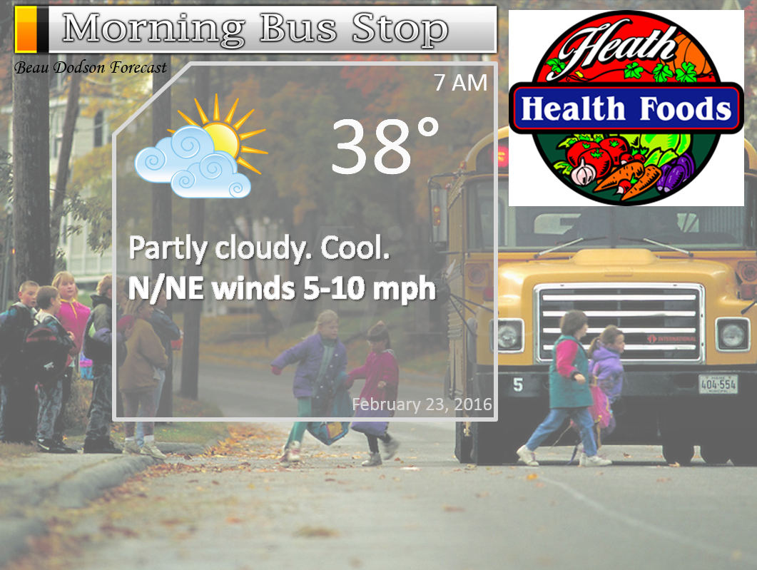
Monday Night – Some increase in clouds.
Temperatures: Lows in the middle 30s
Winds: Northeast winds at 10 mph.
What is the chance for precipitation? 0%
Coverage of precipitation? None
My confidence in this part of the forecast verifying is High
Should I be concerned about snow or ice? No
Should I cancel my outdoor plans? No
Is severe weather expected? No
What impact is expected? None
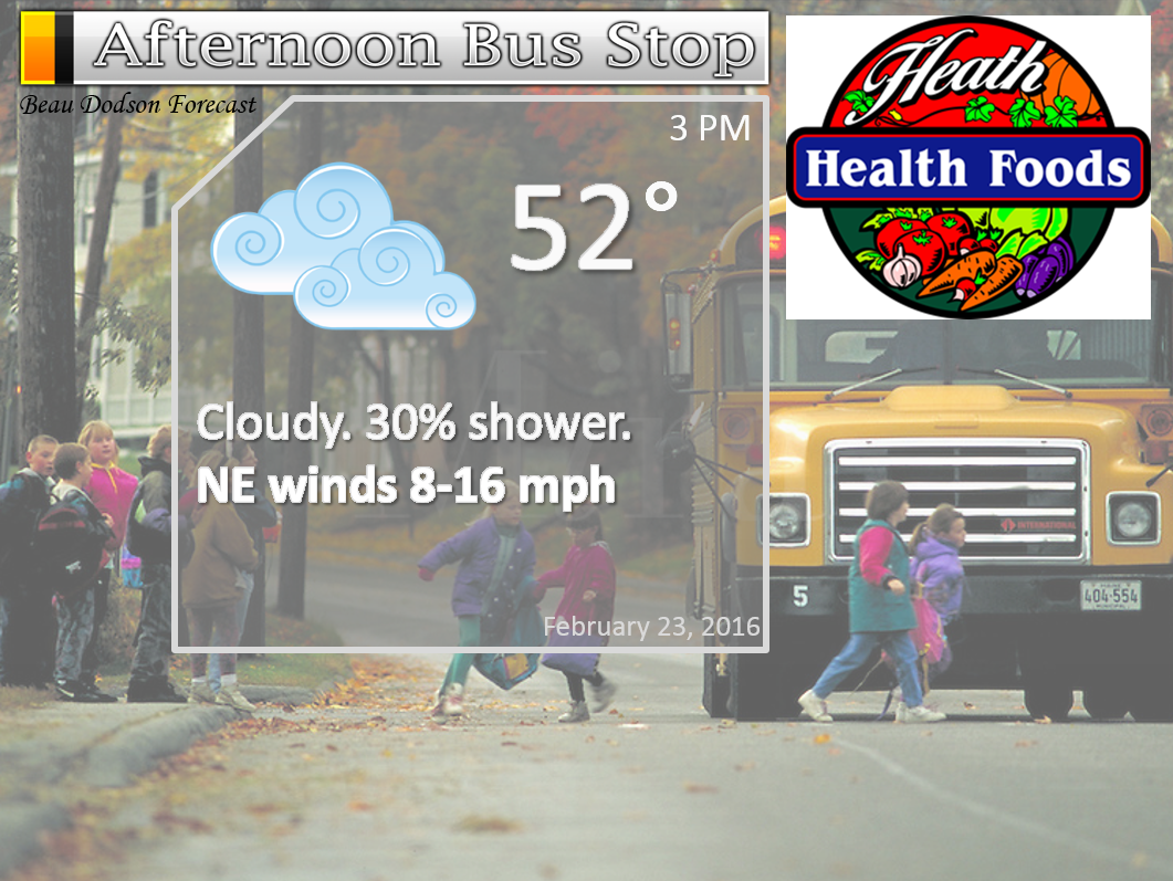
Tuesday – Increasing clouds. Showers increasing during the afternoon from north to south. Best chances late in the day would be over the Missouri Bootheel into northwest Tennessee. And, possibly into western Kentucky. The bulk of the precipitation will arrive on Tuesday night and Wednesday.
Temperatures: Highs in the 50-55 degree range.
Winds: North and northeast at 5-10 mph. Perhaps gusts to 15 mph during the afternoon hours.
What is the chance for precipitation? 30% before 2 pm. 60% after 2 pm.
Coverage of precipitation? Increasing coverage through the day
My confidence in this part of the forecast verifying is Medium
Should I be concerned about snow or ice? No
Should I cancel my outdoor plans? No
Is severe weather expected? No
What impact is expected? Perhaps wet roadways.
Wide range of weather possible over our region on Tuesday night and Wednesday. Snow is more likely over our far western and northwest counties of southeast Missouri and southern Illinois. See full discussion further down in this forecast update.
Tuesday Night – Cloudy. Rain likely. Thunderstorms possible late. Windy. Locally heavy rain possible. We will have to monitor the potential for frozen precipitation over parts of Missouri and Illinois.
Temperatures: Lows in the upper 30s to lower 40s. Rising temperatures possible late at night over Kentucky and Tennessee. Turning colder over our northwest counties.
Winds: North winds at 10-30 mph. Gusts above 40 mph possible.
What is the chance for precipitation? 80%
Coverage of precipitation? Widespread
My confidence in this part of the forecast verifying is High
Should I be concerned about snow or ice? Unlikely for most of us. Will be watching far far western and northwestern counties in southeast Missouri and southwest Illinois.
Should I cancel my outdoor plans? I would consider a backup plan
Is severe weather expected? Not at this time.
What impact is expected? Wet roadways. High winds. Perhaps some accumulating wet snow over parts of Missouri and Illinois. See full discussion further down in this forecast update.
Wednesday – Showers and thunderstorms likely. Strong winds likely. Turning colder over our western counties of southeast Missouri and southwest Illinois. Wet snow possible over southeast Missouri and southern Illinois. Rain may mix with or change to snow area-wide as the system pulls away on Wednesday morning into Wednesday evening. Marginal temperatures for snow. But, monitor updates for adjustments in the forecast.
Temperatures: Highs temperatures will vary greatly. Possibly into the 60s over our southern and southeastern counties and in the middle 30s over parts of southeast Missouri and northwest parts of southern Illinois.
Winds: North and northwest at 15-40 mph. Higher gusts possible. Winds may turn out of the south over parts of western Kentucky and Tennessee on Wednesday morning.
What is the chance for precipitation? 70%
Coverage of precipitation? Widespread
My confidence in this part of the forecast verifying is Medium
Should I be concerned about snow or ice? Parts of the area could experience wet snow.
Should I cancel my outdoor plans? At this time, rain appears likely
Is severe weather expected? Unlikely.
What impact is expected? Windy. Wet roadways. Lightning possible. Will need to monitor for wintry precipitation at least over our western and northwestern counties of southeast Missouri and parts of southern Illinois. And, this could spread eastward during the day. Temperatures will be marginal for this snow event.
Wednesday Night – Cloudy. Turning colder. Any rain showers or snow showers will be coming to an end.
Temperatures: Lows in the 32 to 38 degree range.
Winds: West/northwest winds at 10-15 mph. Gusty.
What is the chance for precipitation? 60% early.
Coverage of precipitation? Scattered
My confidence in this part of the forecast verifying is Low
Should I be concerned about snow or ice? Monitor updates
Should I cancel my outdoor plans? I would consider a backup plan
Is severe weather expected? No.
What impact is expected? Wet roadways. Maybe some wet snow.
Thursday – Some clouds. Small chance for a flurry.
Temperatures: Highs temperatures will mostly be in the 40s.
Winds: North and northwest at 5-10 mph.
What is the chance for precipitation? 10%
Coverage of precipitation? None
My confidence in this part of the forecast verifying is Medium
Should I be concerned about snow or ice? Unlikely
Should I cancel my outdoor plans? No
Is severe weather expected? No
What impact is expected? None expected. If wet snow fell on Wednesday then parts of the area may still be dealing with that.

Don’t forget to check out the Southern Illinois Weather Observatory web-site for weather maps, tower cams, scanner feeds, radars, and much more! Click here

An explanation of what is happening in the atmosphere over the coming days…
Highlights
1. Large storm system approaching our region from Texas, Arkansas, and Louisiana
2. Widespread rain event likely Tuesday afternoon (late) into Wednesday
3. Wet snow on the back side of the storm? And, how much snow?
4. Could this system surprise some areas with heavy wet snow?
Things to remember about this forecast:
Sometimes these events can surprise forecasters with a bit more snow than anticipated. Remember the event last week. The wet snow accumulated at temperatures of 34-38 degrees. Well above freezing. Yet, the heavy snowflakes fell fast enough that it didn’t matter. The snow accumulated.
This event has the potential to produce a band of large wet snowflakes across parts of Missouri and Illinois. The type of event that can produce half dollar size snowflakes. Or, clumping of snowflakes. That happened last week. Some of the snowflakes looked like silver dollars.
The bulk of this event will be rain for most of us. But, the western and northwest side of the system will likely produce some snow. And, as the system pulls away, all of us could see at least snowflakes in the air.
I will be using the texting service throughout this event. Don’t forget to sign up and support all of the weather data you see each day. You can sign up at www.weathertalk.com
Details:
A large storm system is developing to our southwest. If we were sitting in a colder air mass then we might be looking at blizzard warnings for parts of our region on Tuesday night and Wednesday. Rare. But, as luck would have it, the arctic air is locked to our north. Thus, this is mostly a rain event for our region. And, some wet snow possible, as well.
An area of low pressure will develop over Texas, Arkansas, and Louisiana on Monday night and Tuesday morning. This system will then shift northeast into the Tennessee Valley on Tuesday night and Wednesday morning.
Pressure readings could fall below 990 millibars with this system. Deep low! On your home barometers that would be around 29.20″. Impressive for a Tennessee Valley low.
This will create a tight pressure gradient over our region. What is a tight pressure gradient? Isobars are equal lines of barometric pressure. When isobars are tightly packed together you can experience rapid rises and falls of pressure. And, this can help create high winds. Remember last week? We had high winds because of a tight pressure gradient.
This low will be tight.
Here is a graphic example of a pressure gradient. High pressure is normally nice weather. Low pressure is normally unsettled weather. The difference in pressure is the pressure gradient.
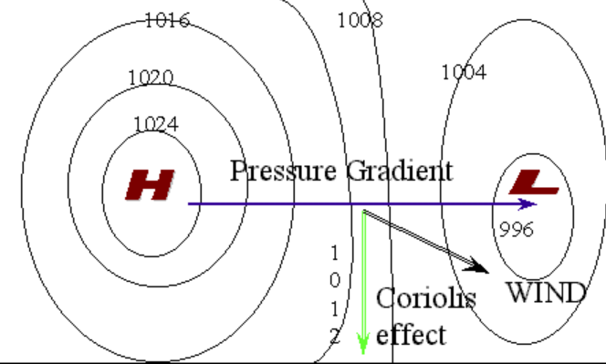
Now, look at the pressure gradient on Wednesday. TIGHT.
I colored the isobars in red across our local region. The low is in Tennessee.
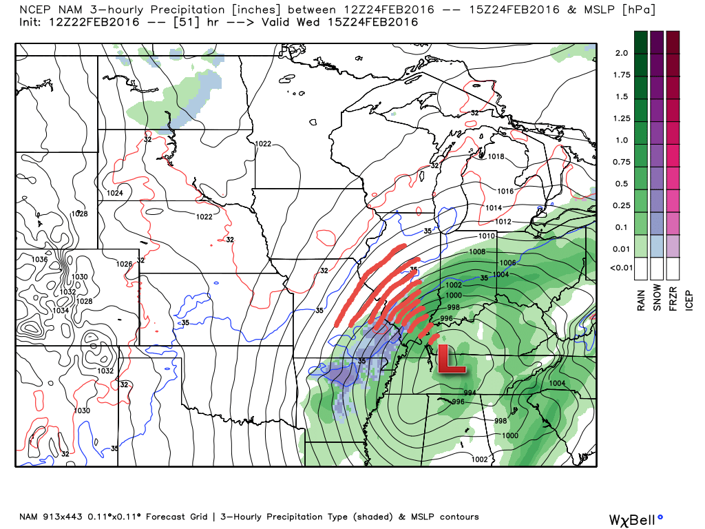
Let’s take a look at the wind gust forecast from the NAM model guidance (NAM is one of many computer models that forecasters work with). Remember, model guidance is not gospel. It is a tool used for guidance.
Certainly some gusts above 40 mph will be possible early Wednesday morning. Perhaps peak winds would be between 3 am and 11 am Wednesday. The highest winds might end up over Missouri and Illinois. This is where the pressure gradient is tightest.
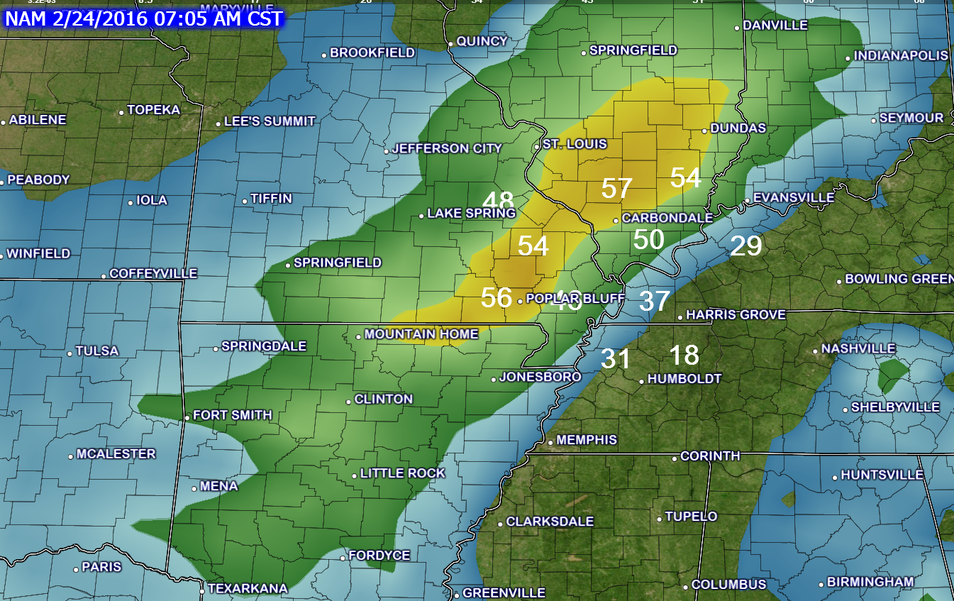
This is the 4 AM NAM model guidance wind gust map. This is what winds could be gusting up to early Wednesday morning. Certainly expecting 30-40 mph gusts. With above 40 mph possible.
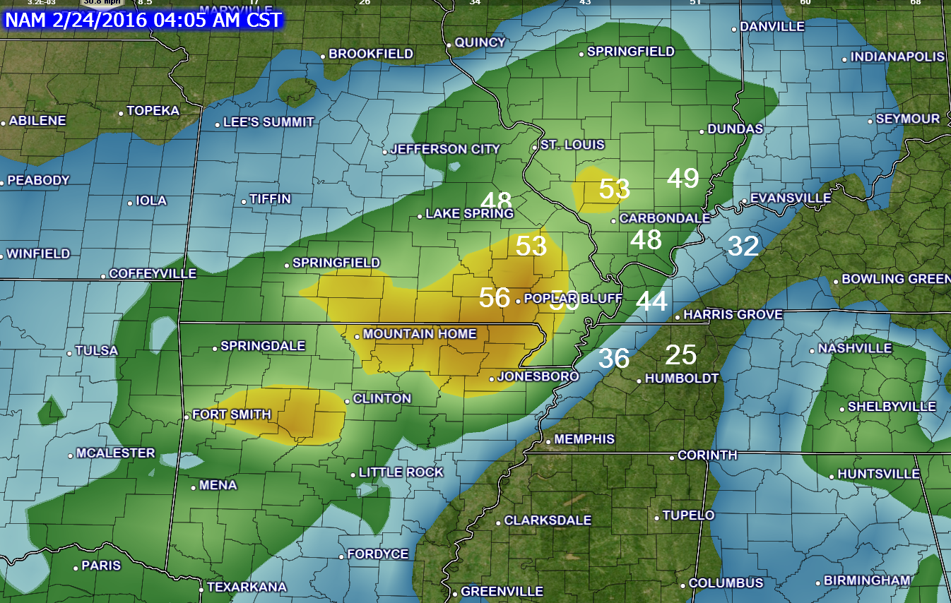
Here is the 9 am wind gust map (Wednesday morning). The NAM guidance is showing some gusts into the 50s. We will see if that happens. Again, at least expect winds to gust into the 30s and 40s.
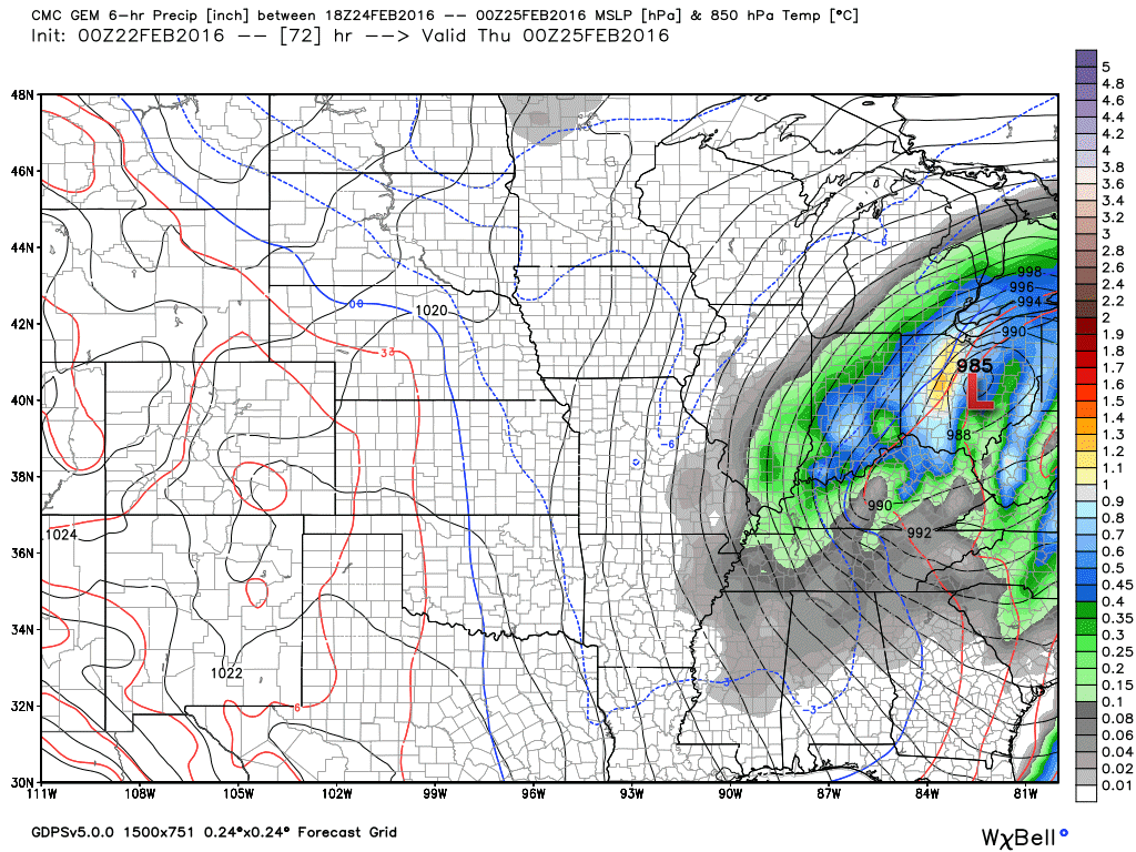
Let’s take a look at the Canadian model guidance on this event. Check out the deep low. Again, your barometer readings will be very low on Wednesday.
These maps are from weatherbell.com. A great source for weather data.
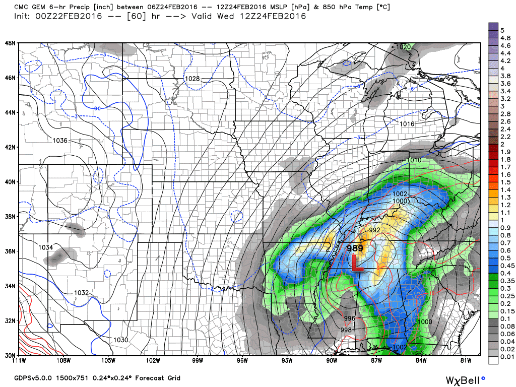
This is the 6 am weather map (Wednesday). See the low? 989 millibars over western/central Tennessee. The low is moving northeast. Colder air is normally on the north and west side of the low. Warmer air on the east and southeast side of the low. I will post a temperature map for this same time period and you can see what I mean.
The colors represent precipitation totals. Six hour totals. This one would be from 12 am Wednesday morning to 6 am Wednesday morning. This is a juicy storm.
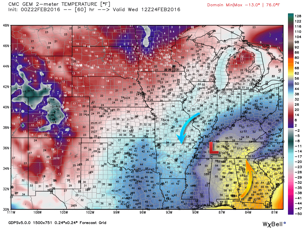
Here is the temperature map for that same time period. 6 am on Wednesday morning. See how the system pulls in warm air ahead of it? And, pulls cold air in behind the low? Remember, a low rotates counterclockwise.
Temperature map. Colors represent temperature. Yellow colors are mild. Blue colors are colder. See the low in Tennessee? Cold air on the back side of the low pressure. Warm air ahead of the low pressure.
Notice the arctic air is locked up in Minnesota and the Dakotas.
Moving ahead to Wednesday noon. The low has tracked northeast into Kentucky.
There could be enough cold air to change the rain to snow over parts of our area. Wet snow. But, the storm is exiting as the colder air arrives. It might be a race between the cold air arriving and the precipitation ending.
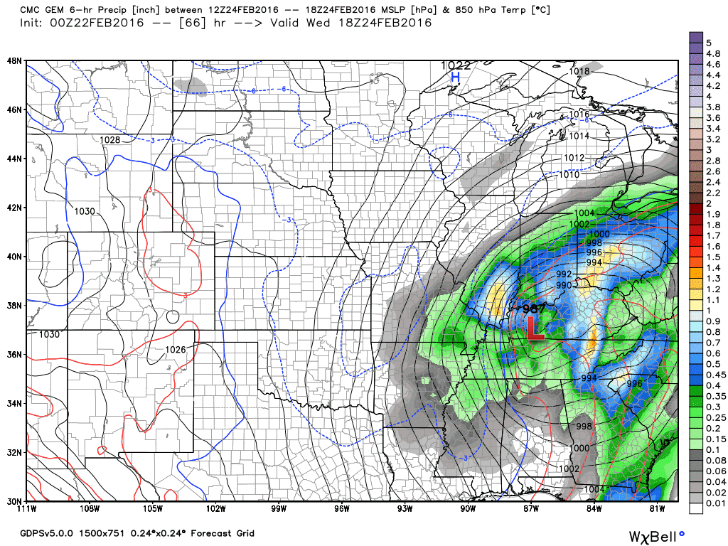
Here is the 6 pm Wednesday weather map. You can see the low has pulled away into Ohio. The GEM has deepened the low pressure area to 985 mb. Deep low pressure! Precipitation is coming to an end over our local area.
The best chance for accumulating snow might end up over our western and northwestern counties. That would include parts of Missouri and Illinois. Questionable, at best, as to how much snow might fall. At least at this point. A few inches are possible.
And, snowflakes in the air might be possible just about anywhere in the region as the system pulls away.
Remember, occasionally systems like this can surprise forecasters. If the air is a bit colder than anticipated (1 to 3 degrees colder) then the odds of accumulating snow increase. And, by the same token, if temperatures are a tad warmer than expected then your snow chances decrease.
I do believe some accumulating wet snow will occur with this event. The real question might be how much.
High winds combined with wet snow could cause some power outages. That would occur if the wet snow does indeed accumulate several inches. If the winds are strong enough then it can knock the snow off of trees and power lines, as well. Sort of a fine balancing act between the two.
Monitor updates.

Wet snow will be possible Tuesday night and Wednesday over parts of south central Missouri into southwest Illinois. I can’t rule out some slushy accumulation. Monitor updates.
Some snowflakes could occur just about anywhere in the region as the system pulls away on Wednesday. But, accumulating snow appears unlikely, at this time, for far southern Illinois, far southeast Missouri, western Kentucky, and northwest Tennessee. However, any shift in the storms path could cause adjustments in the snow forecast.

Tuesday – Currently no snow or ice anticipated.
Tuesday night – Wet snow could develop over south central Missouri (mostly west of Poplar Bluff).
Wednesday – Rain may change to a period of wet snow over southeast Missouri and southern Illinois. And, snowflakes might occur in western Kentucky and northwest Tennessee, as well. Accumulations are unlikely over Kentucky and Tennessee. But, some wet snow may accumulate over parts of southeast Missouri and southern Illinois. However, any shift in the storms path could cause adjustments in the snow forecast.
Thursday – No snow or ice anticipated. Maybe a flurry.
Friday – No snow or ice anticipated.

No major changes in the forecast.

Strong winds on Tuesday night and Wednesday. Winds could gust above 40 mph.
Wet snow is possible on Tuesday night (late) and Wednesday over our western and northern counties. See the map in the discussion above.


The wild card in the forecast will be wet snow. Will there be a band of accumulating wet snow on the northwest side of this system? Parts of southeast Missouri and southern Illinois might fall in the zone of highest probability for a bit of snow. Temperatures are marginal. Lot of questions as to whether the snow will be able to accumulate. But, that is our wild card.

How much precipitation should we expect over the next few days?
Quite a bit of rain is anticipated in our region on Tuesday afternoon into Wednesday afternoon. I believe the bulk of the precipitation will occur on Tuesday night and Wednesday.

Can we expect severe thunderstorms over the next 24 to 48 hours? Remember that a severe thunderstorm is defined as a thunderstorm that produces 58 mph winds or higher, quarter size hail or larger, and/or a tornado.
The thunderstorm threat level will be a ZERO on Monday
The thunderstorm threat level will be a ONE on Tuesday (mostly Tuesday night). Lightning possible.
The thunderstorm threat level will be a ONE on Wednesday. Lightning possible.

Here is the official 6-10 day and 8-14 day temperature and precipitation outlook. Check the date stamp at the top of each image (so you understand the time frame).
The forecast maps below are issued by the Weather Prediction Center (NOAA).


The latest 8-14 day temperature and precipitation outlook. Note the dates are at the top of the image. These maps DO NOT tell you how high or low temperatures or precipitation will be. They simply give you the probability as to whether temperatures or precipitation will be above or below normal.


Here are the current river stage forecasts. You can click your state and then the dot for your location. It will bring up the full forecast and hydrograph.
Click Here For River Stage Forecasts…

Who do you trust for your weather information and who holds them accountable?
I have studied weather in our region since the late 1970’s. I have 37 years of experience in observing our regions weather patterns. My degree is in Broadcast Meteorology from Mississippi State University and an Associate of Science (AS). I am currently working on my Bachelor’s Degree in Geoscience.
My resume includes:
Member of the American Meteorological Society.
NOAA Weather-Ready Nation Ambassador.
Meteorologist for McCracken County Emergency Management. I served from 2005 through 2015.
I own and operate the Southern Illinois Weather Observatory.
Recipient of the Mark Trail Award, WPSD Six Who Make A Difference Award, Kentucky Colonel, and the Caesar J. Fiamma” Award from the American Red Cross.
In 2009 I was presented with the Kentucky Office of Highway Safety Award.
Recognized by the Kentucky House of Representatives for my service to the State of Kentucky leading up to several winter storms and severe weather outbreaks.
I am also President of the Shadow Angel Foundation which serves portions of western Kentucky and southern Illinois.
There is a lot of noise on the internet. A lot of weather maps are posted without explanation. Over time you should learn who to trust for your weather information.
My forecast philosophy is simple and straight forward.
- Communicate in simple terms
- To be as accurate as possible within a reasonable time frame before an event
- Interact with you on Twitter, Facebook, and the blog
- Minimize the “hype” that you might see on television or through other weather sources
- Push you towards utilizing wall-to-wall LOCAL TV coverage during severe weather events
I am a recipient of the Mark Trail Award, WPSD Six Who Make A Difference Award, Kentucky Colonel, and the Caesar J. Fiamma” Award from the American Red Cross. In 2009 I was presented with the Kentucky Office of Highway Safety Award. I was recognized by the Kentucky House of Representatives for my service to the State of Kentucky leading up to several winter storms and severe weather outbreaks.
If you click on the image below you can read the Kentucky House of Representatives Resolution.

Many of my graphics are from www.weatherbell.com – a great resource for weather data, model data, and more


You can sign up for my AWARE email by clicking here I typically send out AWARE emails before severe weather, winter storms, or other active weather situations. I do not email watches or warnings. The emails are a basic “heads up” concerning incoming weather conditions.