12 PM Update
I am leaning more and more towards plain old rain on Saturday. 1-3″ of rain possible. This will melt all of the snow and could cause some flooding concerns.
We will have to deal with snow and sleet before the rain arrives. That will be on Friday and Friday night for wintry mix. That all changes to rain on Saturday for far southern Illinois and western Kentucky.
There are questions as to how much freezing rain will fall before it changes to plain old rain. Accumulations of freezing rain are likely over portions of our area Friday into Saturday morning.
We have our first sponsor for the blog. Milner and Orr Funeral Home and Cremation Services located in Paducah, Kentucky and three other western Kentucky towns – at Milner and Orr they believe in families helping families.
![]()

This forecast update covers far southern Illinois, far southeast Missouri, and far western Kentucky. See the coverage map on the right side of the blog.
Remember that weather evolves. Check back frequently for updates, especially during active weather.
Active weather pattern into the weekend.
Wednesday – Some clouds. Temperatures falling through the day. By evening some parts of southern Illinois may be near 0 degrees. Single digits elsewhere. A snow shower possible. Strong northwest winds at 10-25 mph gusty. Wind chills of -5 in the morning and -5 to -15 in the afternoon (perhaps lower at times towards evening) My confidence in this part of the forecast verifying is high
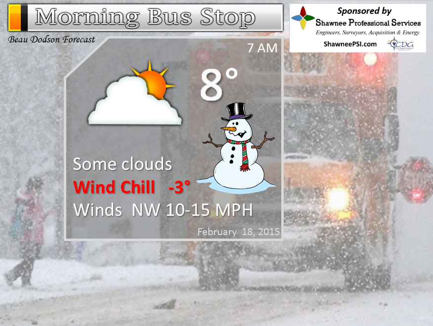
Morning School Bus Stop Weather – Cloudy and cold. Temperatures in the 8 to 15 degree range. Wind chills of -5. Northwest winds at 10-15 mph.
—————————————————————————————-
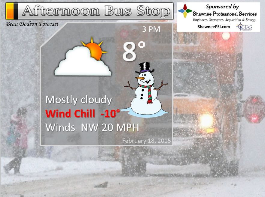
Afternoon School Bus Stop Weather – Some clouds…flurries. BITTERLY cold. Temperatures in the single digits with winds chills of -5 to -10.
Wednesday night – Clearing. Freezing fog possible. Record cold temperatures. Very cold wind chills at times. Temperatures falling into the -2 to -15 range. Temperatures will vary greatly over the region. Wind chills of -20 at times. Northwest winds at 10-25 mph early and then dying down to 10 mph late. My confidence in this part of the forecast verifying is high
Thursday – Some morning sun. Increasing clouds late. Very cold. Highs in the upper teens. Winds north/northwest at 10 mph. My confidence in this part of the forecast verifying is high
Thursday night Become cloudy. A chance for light snow towards morning. Low temperatures from 5 above to 8 below. Temperatures will vary greatly over the region. Winds becoming southeast. – My confidence in this part of the forecast verifying is medium
Friday – A chance for snow and sleet developing. Some accumulation possible. High temperatures in the teens into the afternoon hours. Temperatures may rise towards evening into Friday night as warmer air moves in from the southwest. South/southeast winds at 10 mph. My confidence in this part of the forecast verifying is medium

The School Bus Stop Forecast is brought to your by Shawnee Professional Services. For more information click here

Shawnee Professional Services & Civil Design Group have been providing Land Surveying, Engineering, Grant Administration and Acquisition services for the past 20 years.
Currently Licensed in Illinois, Kentucky, Missouri, Indiana, and Tennessee; please contact Shawnee for any Land Surveying or Engineering needs.
Shawnee’s company size allows them to devote individual attention to each client and to approach each project with the required thoroughness to successfully complete the project, large or small.
Shawnee combines innovative thinking and proven techniques, completing projects cost-effectively for their clients. Visit Shawnee’s website at shawneepsi.com for more information. Shawnee has offices in Paducah, KY, Vienna, IL and Benton, IL.
Current Temperatures Around The Local Area


An explanation of what is happening in the atmosphere over the coming days…
Your weatherman has been plenty busy over the last few days. There is a lot going on! Let’s go over some of it.
Temperatures on Tuesday morning dipped to levels that many of us have not witnessed since the 1970’s or before. There were some -10 readings around southern Illinois, southeast Missouri, and western Kentucky. I saw a few reports of -15 (and even lower). These are crazy temperatures for this area. Historic cold. Of course, when you have widespread 4-12 inches of snow on the ground – that can happen.
We had a weak weather system move through the area on Tuesday night. This produced a band of snow that moved west to east through the area. As of this writing (late Tuesday night) light snow was falling over much of southern Illinois, southeast Missouri, and parts of western Kentucky.
My forecast was for 1-2 inches of snow with this event. Then I had some lower probabilities of greater amounts. I guess when I wake up in the morning I will see how the forecast verified.
I am trying to figure out if anyone would know if 1″-2″ of snow fell overnight! At least not in your yard. With all of the snow already on the ground – hard to tell if an inch fell on top of it. Of course we don’t want any additional snow on the roadways.
We have major weather challenges ahead of us…
I am going to break this down as best I can.
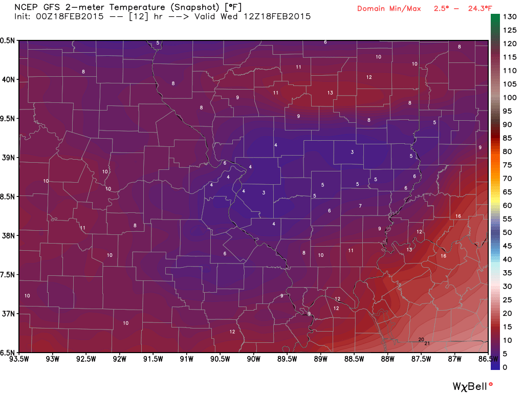
A strong influx of cold air arrives later this morning and this afternoon. Instead of temperatures rising this afternoon they will actually fall. By sunset we may see some 0 to 5 degree readings over southern Illinois. Single digits will invade all of our counties by evening. Gusty winds, as well.
Let’s take a look at some of those temperatures on these model maps
This is for Wednesday morning – watch how temperatures fall into the afternoon hours
This is for the sunset hour. Brrr is the word.
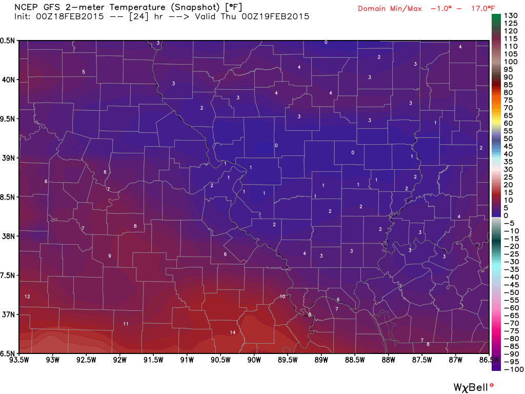
Wind chill values this afternoon and tonight will fall into the -5 to -20 range. Very cold.
By Thursday morning we will have a wide range of temperatures over the region. Cold air is funny. For example – on Monday night I watched Marion, Illinois drop to 2 degrees. At the same time Carbondale, Illinois was 12 above. That is a short distance for such a big temperature difference. Snow pack can cause dramatic temperature differences from one location to the next. Combine that with calm winds and clear sky conditions and you get some wild temperature swings.
The temperatures you will view on your local TV weather station may not reflect what actually happens tonight. How many of you knew that Cape Girardeau was -10 on Tuesday morning? How about -11 north of Mayfield, Kentucky? You probably didn’t hear about that on the news.
I would not be a bit surprised if some areas dip into the -15 range tonight. Many areas will be -2 to -10 degrees. Record cold temperatures for the date.
Friday morning will bring additional below zero readings. I believe the coldest air on Friday morning will be over southwest Indiana into Kentucky.
Wintry weather may return late Thursday night or Friday…
A mixture of snow and sleet will develop on Friday morning. This precipitation may develop as early as 12 am to 6 am over parts of southeast Missouri. A bit unsure of this part of the forecast.
Wintry weather will overspread the entire region on Friday afternoon. A mixture of snow and sleet will eventually transition to a period of freezing rain.
A warm front will approach our region on Friday night. If this front can push through our area then we are looking at a lot of rain on Saturday.
Some of the models are painting inches of rain on Saturday. Still early to make an official forecast on where the freezing line ends up Saturday and how much precipitation will fall. Of course this will be key to precipitation type.
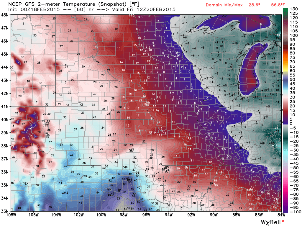
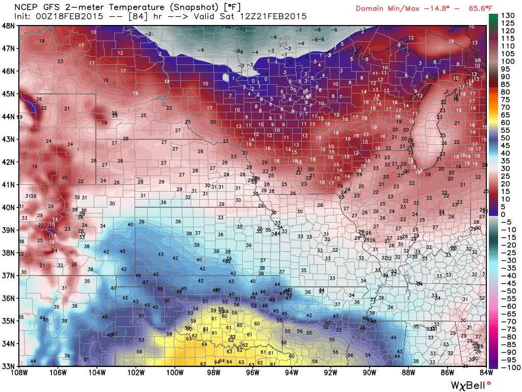
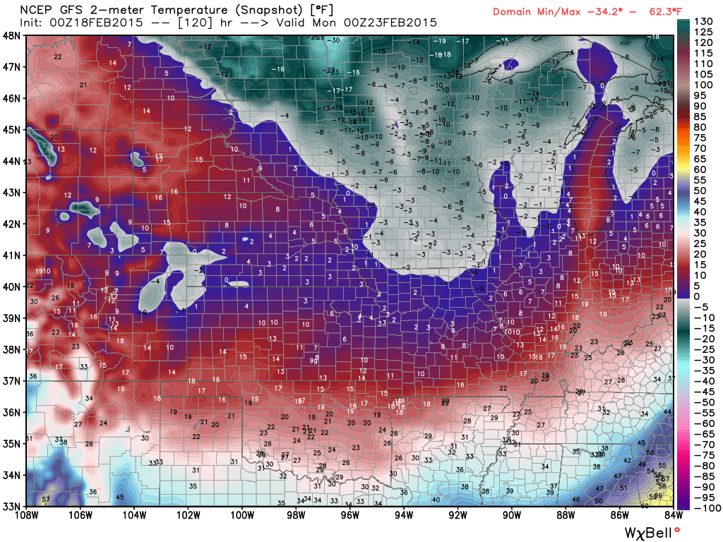
Here are the model temperature forecasts for Friday morning, Saturday morning, and then on Sunday
Friday morning temperatures – I want you to watch how temperatures rise over the coming days. This is good news if you want the snow to melt. It would be GREAT if we could go above freezing on Friday night and Saturday. That will spare us from a lot of frozen precipitation. Of course it could also mean a lot of heavy rain from a system coming in from the southwest.
Temperatures on Saturday morning. See the warm air to our southwest down in Texas and Arkansas? That is moving our way.
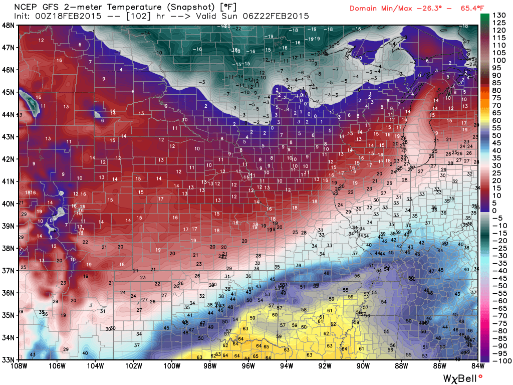
Saturday night at 11 pm to Sunday morning at 1 am – the GFS is showing milder air over our area with a lot of rain (below)
Temperatures by Sunday afternoon (below). Coldest air moving back into the area.
If the warm air doesn’t make it into our region then we are looking at the potential for a wintry mix to continue into Saturday night. This would include snow, sleet, and freezing rain. Too soon to get all worked up and worried about totals.
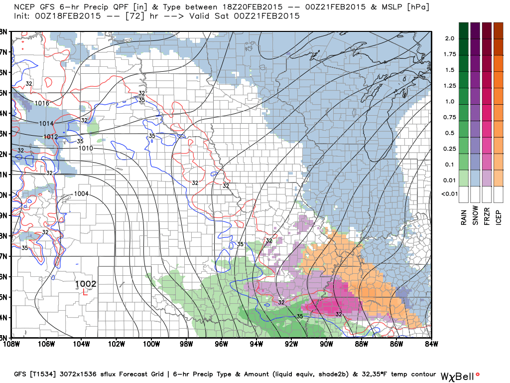
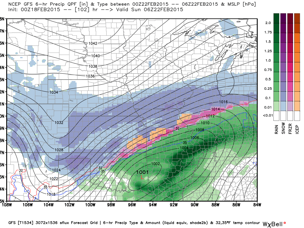
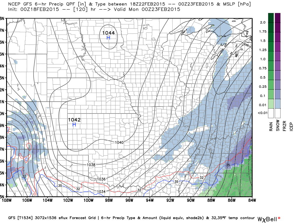
Let’s take a look at what the GFS model is showing for Friday and Saturday. A whole whole lot of rain on Saturday.
This is what the GFS believes the weather map will look like on Friday. Some wintry mix in our region. Too soon to say how much.
This is for Saturday. Very heavy rain over our region per this model. Just one model – but other data indicates the potential for heavy rain, as well. Frozen ground – deep snow pack – heavy rain? Does not really go together. This could melt all the snow and quickly.
This is for Sunday. Light snow at the end of the system. Again, this is the GFS models opinion.
I am watching it constantly and watching for trends in the data.
I am leaning mostly plain old rain on Saturday with 1-3 inches possible.
Monitor updates…one forecast isn’t going to get it with the Friday into Saturday night time period. Many updates will be needed before I pin down how this will unfold.
Colder air arrives for Monday and Tuesday. Another big system in the charts next week? Maybe. Seeing some indications of that. Active pattern underway.
Additional maps below
We have a new sponsor! G&C Multi-Services out of Paducah, Kentucky. G & C Multi-Services is a service provider in Western Kentucky that provides industrial and commercial equipment fabrication, machine troubleshooting, repair and maintenance, and installation. They can custom fabricate steel, stainless, and aluminum products per customer specifications.
Visit their web-site here. Or click the ad below! They have a Facebook page and it can be viewed here.


WANT TO HELP SUPPORT THIS BLOG AND COVER EXPENSES?
Did you know that the Weather Observatory is funded by people like you? I rely on ad’s on this blog and individual donations. PayPal also allows you to set up a monthly recurring donation. I have had several people give $5, $10, and $20 a month. A recurring donation helps keep the weather information flowing. If you enjoy this blog, the Twitter account, the Facebook interaction, the weather radars, and all of the other information then consider making a donation or setting up a recurring donation (if you don’t use PayPal then contact me through email about how you can mail a donation) beaudodson@usawx.com
Or mail a check to
Beau Dodson
3954 Mermet Road
Belknap, IL
62908
Thank you for your support!

Very cold temperatures this afternoon into Friday.
More wintry precipitation possible on Friday and Friday night.
Heavy rain on Saturday in or near our region? Monitor updates.
Check out our newest sponsors $5 meal! The DQ Grill and Chill (located across from Noble Park in Paducah, Kentucky) is the newest WeatherTalk Blog sponsor! A local business helping to sponsor the weather information that you have come to love so much.
They have a Facebook Page and I encourage you to check it out. DQ Grill and Chill on Facebook


The wild card tells you where the uncertainties are in the forecast
Wild card in this forecast -The short term wild card will be temperatures tonight. How low will they go! Appears widespread below zero readings will occur. Some spots may be WELL below zero.

Can we expect severe thunderstorms over the next 24 to 48 hours? Remember that a severe thunderstorm is defined as a thunderstorm that produces 58 mph winds or higher, quarter size hail or larger, and/or a tornado.
Thunderstorm threat level is ZERO through Friday


Will I need to take action?
Very cold air today into Friday. Pipe busting cold, obviously. The longest stretch of single digits to below zero readings will be this afternoon into Thursday morning.
Snow and sleet may return to the area on Friday. That would mean additional hazardous driving conditions for some areas. Stay tuned for updates on this.
Watching Saturday for possible heavy rain in or near our region.

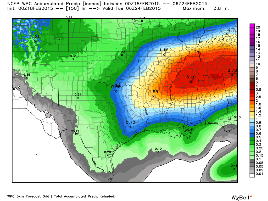
How much precipitation should we expect over the next few days?
This is going to have to be updated over the coming days.
We have all sorts of precipitation chances from Friday into Sunday morning. The placement of the warm front is going to be key to where the heaviest rain falls (or other precipitation types)
Here is the official precipitation forecast for the next 5 days.
Again, subject to big adjustments.

Who do you trust for your weather information and who holds them accountable?
I have studied weather in our region since the late 1970’s. I have 37 years of experience in observing our regions weather patterns. My degree is in Broadcast Meteorology from Mississippi State University and an Associate of Science (AS). I am currently working on my Bachelor’s Degree in Geoscience. Just need to finish two Spanish classes!
I am a member of the American Meteorological Society. I am a NOAA Weather-Ready Nation Ambassador. And, I am the Meteorologist for McCracken County Emergency Management.
I own and operate the Southern Illinois Weather Observatory.
There is a lot of noise on the internet. A lot of weather maps are posted without explanation. Over time you should learn who to trust for your weather information.
My forecast philosophy is simple and straight forward.
- Communicate in simple terms
- To be as accurate as possible within a reasonable time frame before an event
- Interact with you on Twitter, Facebook, and the blog
- Minimize the “hype” that you might see on television or through other weather sources
- Push you towards utilizing wall-to-wall LOCAL TV coverage during severe weather events
I am a recipient of the Mark Trail Award, WPSD Six Who Make A Difference Award, Kentucky Colonel, and the Caesar J. Fiamma” Award from the American Red Cross. In 2009 I was presented with the Kentucky Office of Highway Safety Award. I was recognized by the Kentucky House of Representatives for my service to the State of Kentucky leading up to several winter storms and severe weather outbreaks.
If you click on the image below you can read the Kentucky House of Representatives Resolution.

I am also President of the Shadow Angel Foundation which serves portions of western Kentucky and southern Illinois.

We have regional radars and local city radars – if a radar does not seem to be updating then try another one. Occasional browsers need their cache cleared. You may also try restarting your browser. That usually fixes the problem. Occasionally we do have a radar go down. That is why I have duplicates. Thus, if one fails then try another one.
If you have any problems then please send me an email beaudodson@usawx.com
WEATHER RADAR PAGE – Click here —
We also have a new national interactive radar – you can view that radar by clicking here.
Local interactive city radars include St Louis, Mt Vernon, Evansville, Poplar Bluff, Cape Girardeau, Marion, Paducah, Hopkinsville, Memphis, Nashville, Dyersburg, and all of eastern Kentucky – these are interactive radars. Local city radars – click here
NOTE: Occasionally you will see ground clutter on the radar (these are false echoes). Normally they show up close to the radar sites – including Paducah.

Regional Radar – Click on radar to take you our full radar page.


Regional Radar
![]()
Current WARNINGS (a warning means take action now). Click on your county to drill down to the latest warning information. Keep in mind that there can be a 2-3 minute delay in the updated warning information.
I strongly encourage you to use a NOAA Weather Radio or warning cell phone app for the most up to date warning information. Nothing is faster than a NOAA weather radio.


Color shaded counties are under some type of watch, warning, advisory, or special weather statement. Click your county to view the latest information.

Missouri Warnings

Illinois Warnings

Kentucky Warnings

Please visit your local National Weather Service Office by clicking here. The National Weather Service Office, for our region, is located in Paducah, Kentucky. They have a lot of maps and information on their site. Local people…local forecasters who care about our region.


Here is the official 6-10 day and 8-14 day temperature and precipitation outlook. Check the date stamp at the top of each image (so you understand the time frame).
The forecast maps below are issued by the Weather Prediction Center (NOAA).


The latest 8-14 day temperature and precipitation outlook. Note the dates are at the top of the image. These maps DO NOT tell you how high or low temperatures or precipitation will be. They simply give you the probability as to whether temperatures or precipitation will be above or below normal.


Many of my graphics are from www.weatherbell.com – a great resource for weather data, model data, and more


This blog was inspired by ABC 33/40’s Alabama Weather Blog – view their blog
Current tower cam view from the Weather Observatory- Click here for all cameras.

Southern Illinois Weather Observatory

The Weather Observatory

Southern Illinois Weather Observatory
WSIL TV 3 has a number of tower cameras. Click here for their tower camera page & Illinois Road Conditions

Marion, Illinois
WPSD TV 6 has a number of tower cameras. Click here for their tower camera page & Kentucky Road Conditions & Kentucky Highway and Interstate Cameras

Downtown Paducah, Kentucky
Benton, Kentucky Tower Camera – Click here for full view

Benton, Kentucky

I24 Paducah, Kentucky

I24 Mile Point 9 – Paducah, KY

I24 – Mile Point 3 Paducah, Kentucky

You can sign up for my AWARE email by clicking here I typically send out AWARE emails before severe weather, winter storms, or other active weather situations. I do not email watches or warnings. The emails are a basic “heads up” concerning incoming weather conditions.