Updated probability maps for tonight’s snow event
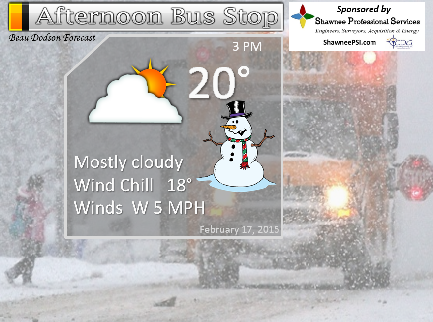
3 PM Update
February 17, 2015:
Forecast is for tonight (but will mention the next winter storm threat)
Fast moving squally line of snow will move through the area tonight between 7 pm and 3 am. The line will move from west to east.
Record low temperatures again likely on Wednesday night and Thursday.
Certainties…
1. Snow will develop over Missouri and Arkansas this evening and move east into southern Illinois and western Kentucky (mostly after 7 pm).
2. Winds of 20-30 mph later tonight. Some blowing snow possible.
3. Accumulations of 1-3″ of snow will be possible. Isolated higher totals perhaps along the KY/TN border. Low chance of that occurring, but worth mentioning.
4. Travel problems will continue into at least Saturday morning. Widespread school closings likely to continue.
5. Temperatures on Wednesday will fall into the single digits during the afternoon
6. Wind chills will range from 0 to 20 below on Wednesday afternoon into early Thursday morning. These are dangerous levels for people outside (and pets)
7. Record low temperatures on Thursday morning. Widespread actual air temperatures of -2 to -10 with isolated pockets of -15 or lower possible.
8. Snow and sleet redevelop on Friday or Friday night. This will change to freezing rain on Friday night/Saturday morning. Medium confidence on the Friday forecast.
9. Potential for heavy rain on Saturday changing back to frozen precipitation on Saturday night into Sunday. Low confidence on the Saturday and Sunday part of this discussion
Uncertainties…
1. How much precipitation will fall on Friday into Sunday.
2. Unsure on when the precipitation will turn to just plain old rain on Saturday. A period of freezing rain is likely before it changes to plain old rain. Freezing rain is rain that falls from the sky and then instantly freezes to ice on whatever it touches. Sleet would be the little pellets that look like bb’s.
Time of development…
The bulk of tonight’s light snow event will be between 7 pm and 3 am. A little unsure exactly what time the main band will hit the Mississippi River. Thinking between 7 pm and 10 or 11 pm. It will then move eastward.
Gusty winds of 10-25 mph (perhaps gusts to 30 mph) will accompany this system. This will cause some of the dry snow to blow around. It will also make it feel a lot colder outside.
On Wednesday a new arctic blast of air arrives. Temperatures will peak on Wednesday morning and fall into the single digits by afternoon. Winds will also pick up. Winds may gust between 20-30 mph. A few gusts over 40 mph will be possible over southern Illinois.
Very cold wind chills are likely later on Wednesday afternoon into the wee early morning hours of Thursday.
Record low temperatures are going to occur on Thursday morning. Some records will be shattered. It is possible the State of Kentucky could set some all time record lows on Thursday or Friday morning – most likely over the eastern half of the state.
Temperatures in our region will range from -2 to -10. There certainly could be some readings lower than that.
Temperatures earlier this morning dipped to -10 in Cape Girardeau, Missouri. I did see some -11 to -15 readings reported over southern Illinois and western Kentucky. These very low temperatures can occur in isolated spots. Amazing temperatures for our region.
A new storm system approaches our region on Friday. A mixture of snow and sleet will develop over Arkansas and move northeast. This precipitation should overspread our region late on Friday or Friday night.
Sleet should change to a period of freezing rain on Friday night and Saturday morning. Too soon to know amounts. The good news is that we may see temperatures rise above freezing on Saturday. Hopefully that will be the case.
Some of the models are showing heavy rainfall totals in our region Saturday into Saturday night. This will depend on the placement of an area of low pressure moving through Arkansas. If heavy rain develops then flash flooding may be a concern.
Colder air will push back into the area on Saturday night and the rain may change back to freezing rain and sleet.
The forecast for Friday into the weekend will evolve. Changes are likely – adjustments are likely. I would encourage those who have an interest in this weather event to closely monitor and follow the very latest information.
For frequent updates please visit your local National Weather Service Office web-site and the Beau Dodson Weather Facebook page for current forecast threads. During severe weather please follow local media for wall to wall coverage.
———————————–
Storm Tracking Tools:
1. Radars to track storms – click here
2. Latest watches/warnings – click here
4. Weather Observatory Main web-site – click here
———————————-
Monitor NOAA Weather Radio and local media for updated information.
Find your local National Weather Service Office here – http://www.nws.noaa.gov/organization.php#maps – for the latest warnings and other information.
We have numerous interactive radars running during weather events – see the local city radars for the interactive features
http://www.weatherobservatory.com/weather-radar.htm
11 AM UPDATE
Winter weather advisory for the whole area tonight.
Thinking is that 1-3″ of snow will fall. Fluffy snow. Light. This will not help road conditions.
Temperatures on Wednesday may not get out of the single digits. By Thursday morning temperatures will fall into the 0 to 15 below range.
Snow develops Friday and changes to sleet and freezing rain Friday night. Stay tuned

We have regional radars and local city radars – if a radar does not seem to be updating then try another one. Occasional browsers need their cache cleared. You may also try restarting your browser. That usually fixes the problem. Occasionally we do have a radar go down. That is why I have duplicates. Thus, if one fails then try another one.
If you have any problems then please send me an email beaudodson@usawx.com
WEATHER RADAR PAGE – Click here —
Advisories

We have our first sponsor for the blog. Milner and Orr Funeral Home and Cremation Services located in Paducah, Kentucky and three other western Kentucky towns – at Milner and Orr they believe in families helping families.
![]()

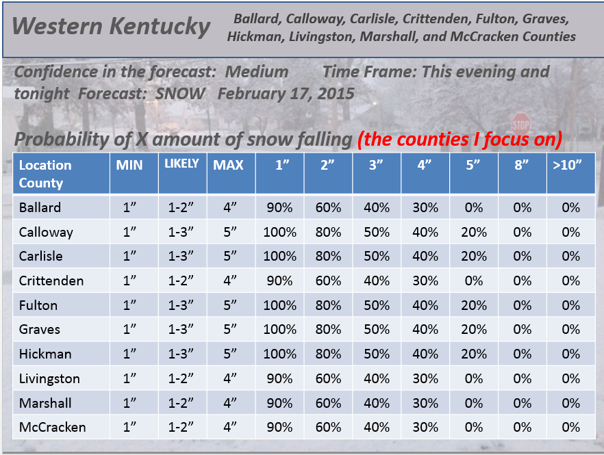
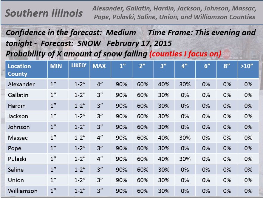
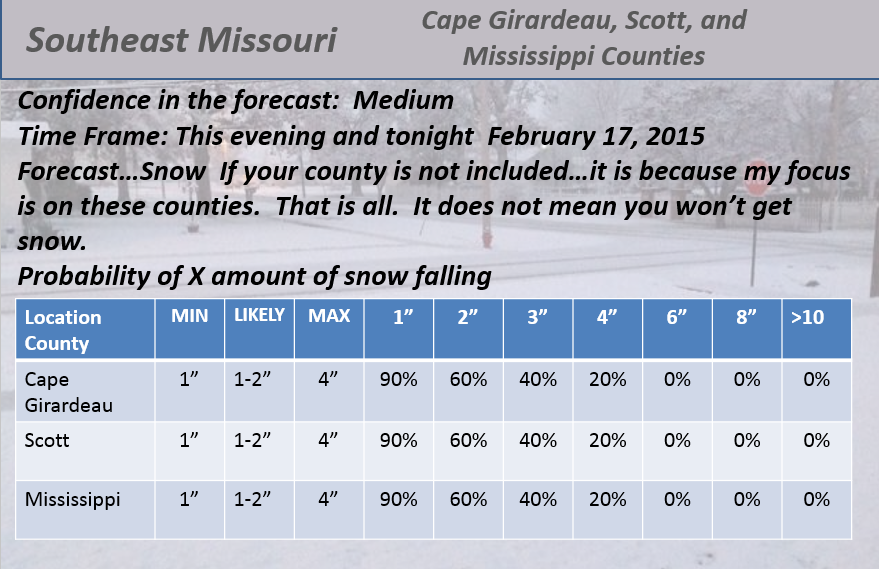
This forecast update covers far southern Illinois, far southeast Missouri, and far western Kentucky. See the coverage map on the right side of the blog.
Remember that weather evolves. Check back frequently for updates, especially during active weather.
Tuesday – A mix of some sun and clouds. Cold. Highs from 15 to 25. Northwest winds at 5-10 mph. My confidence in this part of the forecast verifying is high
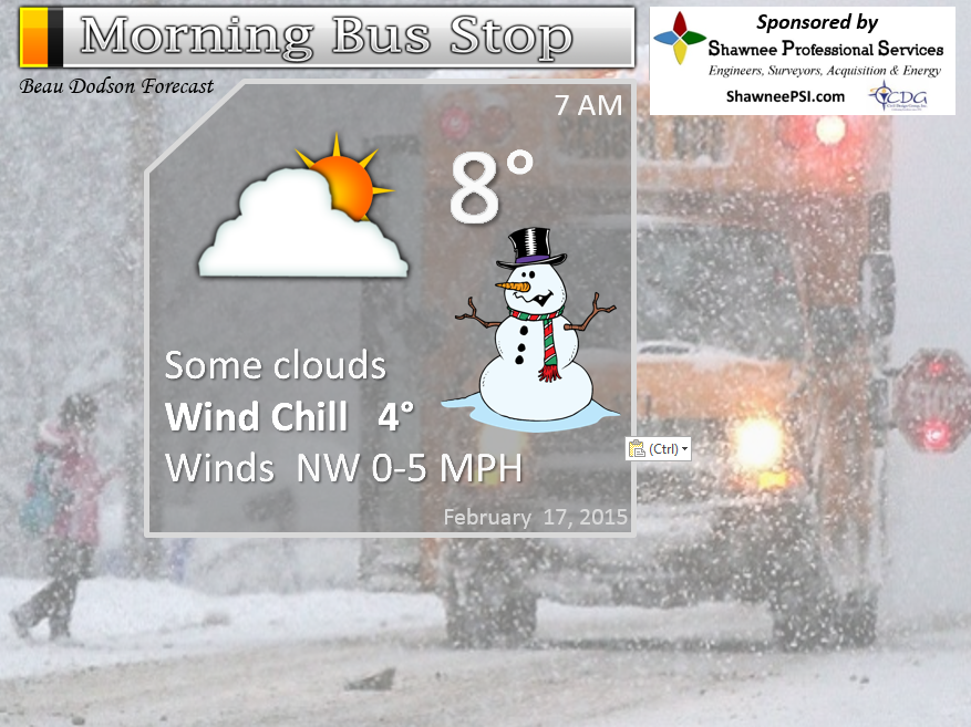
Morning School Bus Stop Weather – Most schools are closed. Morning temps in the 8-12 degree range. Light winds.
—————————————————————————————-
Afternoon School Bus Stop Weather – Cold – temperatures around 20 degrees.
Tuesday night – Mostly cloudy. A period of light snow possible. Accumulations of perhaps a dusting to 2″. Not sure anyone would know if it snowed! Lows of -3 parts of southern Illinois to perhaps 10-12 degrees in areas without much snow cover. Northwest winds at 5 mph. My confidence in this part of the forecast verifying is high
Wednesday – Some clouds – very cold. Flurry possible. Falling temperatures. Temperatures may fall into the single digits and teens during the afternoon. Windy at times with bitterly cold wind chills. Temperatures during the morning will be in the 8 to 15 degree range. Temperatures won’t really recover during the day. My confidence in this part of the forecast verifying is high
Wednesday night – Clearing. Record cold. Lows from 0 to -10 degrees. North winds at 10 mph. Pipe busting cold weather. My confidence in this part of the forecast verifying is high
Thursday – Some clouds. Very cold. Flurry possible. Highs in the teens. Northwest winds at 5-10 mph. My confidence in this part of the forecast verifying is high
Friday – Snow developing and then ice.

The School Bus Stop Forecast is brought to your by Shawnee Professional Services. For more information click here

Shawnee Professional Services & Civil Design Group have been providing Land Surveying, Engineering, Grant Administration and Acquisition services for the past 20 years.
Currently Licensed in Illinois, Kentucky, Missouri, Indiana, and Tennessee; please contact Shawnee for any Land Surveying or Engineering needs.
Shawnee’s company size allows them to devote individual attention to each client and to approach each project with the required thoroughness to successfully complete the project, large or small.
Shawnee combines innovative thinking and proven techniques, completing projects cost-effectively for their clients. Visit Shawnee’s website at shawneepsi.com for more information. Shawnee has offices in Paducah, KY, Vienna, IL and Benton, IL.
Current Temperatures Around The Local Area


An explanation of what is happening in the atmosphere over the coming days…
Wow! Well hello winter. Is that you? I believe it is.
Highlights…
1. Very cold into Friday
2. Light snow tonight (Tuesday night). Maybe a dusting to an inch or two.
3. Temperatures on Wednesday may fall into the single digits during the afternoon hours
4. Coldest night will probably be Wednesday night with widespread 2 above to -5 and some places may see -10 readings
5. Freezing rain, sleet, or snow possible on Friday/Friday night
6. Rain or a mixture on Saturday.
7. Rain changing back to mixture possible Saturday night
Woosh – is that going to be a headache to forecast for? Yes, yes it is!
Widespread snow fell over the region – just about every single county that I forecast for picked up at least 4″ of snow. Most of you picked up anywhere from 6 to 12 inches! Some big totals right across far far southern Illinois and western Kentucky. Some banding enhanced totals in a few spots.
This snow is not going to melt anytime soon. Major cold outbreak is going to mean record lows over the coming days. Not a pretty picture.
Temperatures on Tuesday morning are below zero in many spots, already.
We have additional winter weather concerns. Let me pick this apart the best I can. I am going to combine the long range with the analysis.
We have a chance of light snow this evening and tonight. Maybe a dusting to an inch or two in spots. I am a little uncertain as to how far east to place the best lift with this little wave diving down out of Iowa. Keep in mind…there may be light snow tonight.
Here is the future-cast radar for this evening. Quick moving band of snow showers.
Major concerns for record breaking cold over the coming days. Historically cold outbreaks like this cost our region big bucks. Broken pipes, increased house fires, dead car batteries, and more.
The coldest temperatures will be on Thursday morning. I can’t rule out some -10 readings in the area. Keep this in mind. Records will fall. Records that date back to the 1950’s.
We will have small ripples of energy moving through a very fast jet stream flow over the coming days. Each one of these waves could produce snow flurries or even a brief snow shower.
Again, one of those waves will move through later this evening. It will be moving out of Iowa and into northern Missouri – then into southern Missouri and perhaps parts of southern Illinois and western Kentucky. Again, does not look to be a big deal. But, a period of light snow will be possible.
Another wave arrives later on Thursday night and Friday. Some data paints light accumulations from that event. I will update as we move forward.
A bigger system may form on Friday – this is up for debate and I will post you some maps below.
Saturday we should see widespread precipitation in the region. Type of precipitation? Rain or frozen? This will need to be monitored. Whether we go above freezing or not – some of the data is showing 40’s. We will see.
We should see a decent return of warm air with southwest winds. But, with all of this snow – there are some questions on exactly what temperatures will look like on Saturday. Rain or frozen likely, either way.
Again, the big big story over the coming days will be bitterly cold air.
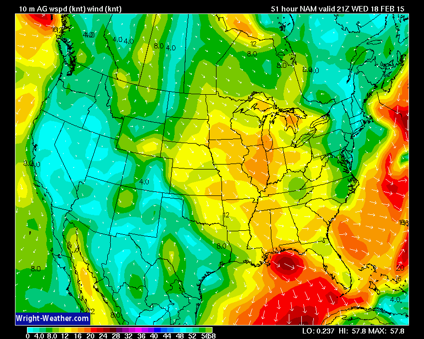
On Wednesday the high temperatures will occur during the morning hours. Highs will be in the upper teens or lower 20’s. By afternoon temperatures will have fallen into the single digits over parts of the area. By Thursday morning most areas will be at or below zero. Gusty winds on Wednesday will mean wind chills well below zero, as well.
Here is the wind forecast map for Wednesday. This is for around the 3 pm time frame. Winds of 10-25 mph combined with single digit temperatures. That means wind chills will be well below zero.
I have concerns about a potential weather pattern developing Friday into next week. A stationary front may drape itself across our region or just south of us. Multiple shortwaves (systems) are forecast to move along this boundary. Each one will throw moisture into the cold air over our region.
One model develops a deeper low that moves out of Arkansas and towards our region. Other data simply strings each system along the boundary.
Rain, freezing rain, sleet, and snow may once again visit our region with each of these systems. Some of the data indicates we may see multiple rounds of frozen precipitation. Not ready to bank on that happening just yet, but I want you to be aware of the possibility of more winter weather.
Another major blast of cold air is possible next week.
Remember when I told you the last two weeks of February were going to be quite interesting? Winter wasn’t finished.
Let’s check out some charts…
Future-cast radar for 12 pm today. You can see that small area of snow skirting through Missouri (the blue area). This may drop a quick dusting to an inch over parts of central and maybe southern Missouri. Believe our region won’t see too much from it. But, there may be some snow showers.
Images from www.weatherbell.com
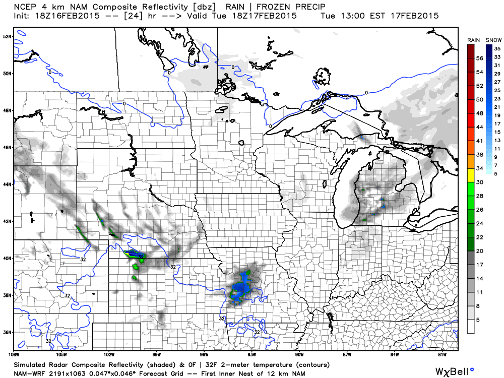
Here is the 5 pm future-cast radar. What radar might look like later this evening. That gray area would be light snow showers and flurries.
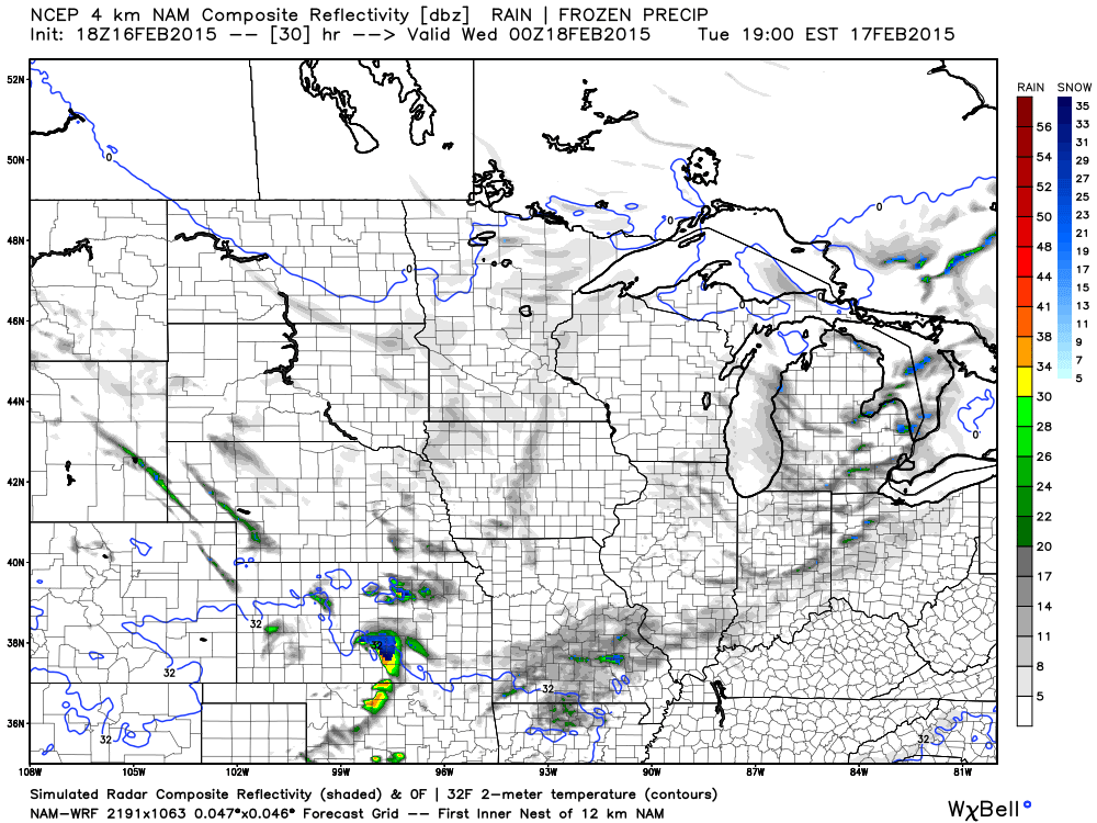
And finally, future-cast radar for around 12 am tonight. You can see some snow showers in the area.
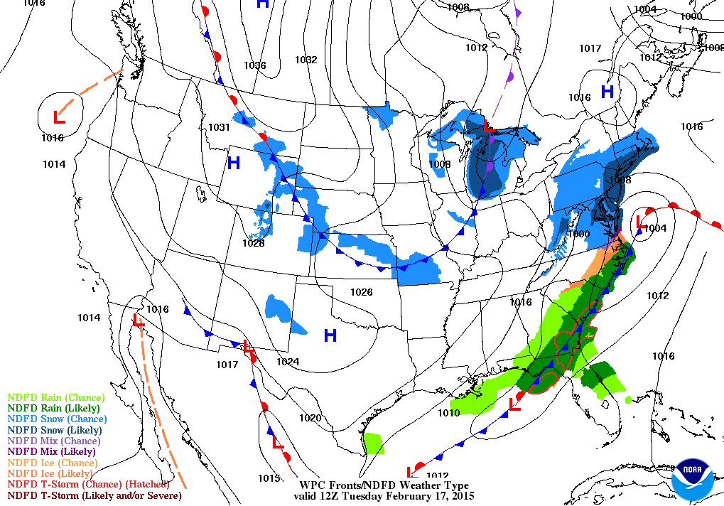
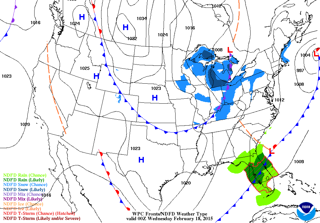
Here is the national weather map for this Tuesday morning. You can see a cold front stretching across the region. The second map is for this evening. Cold front over our area with some flurries or snow showers along it.
Can you find the storm that moved through here on Monday? It is moving up the East Coast. What? More snow for the northeast? Shocker.
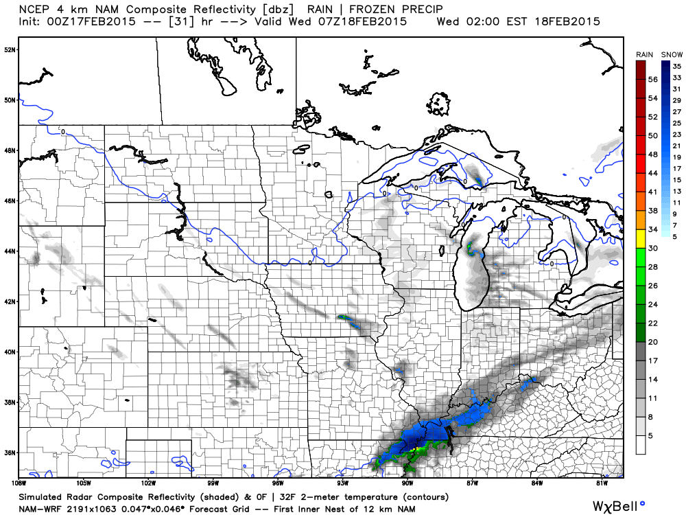
On Thursday night a system dives down from the northwest. You can see it here on the NAM model. This area of light snow will push across our region. There could be some light accumulation.
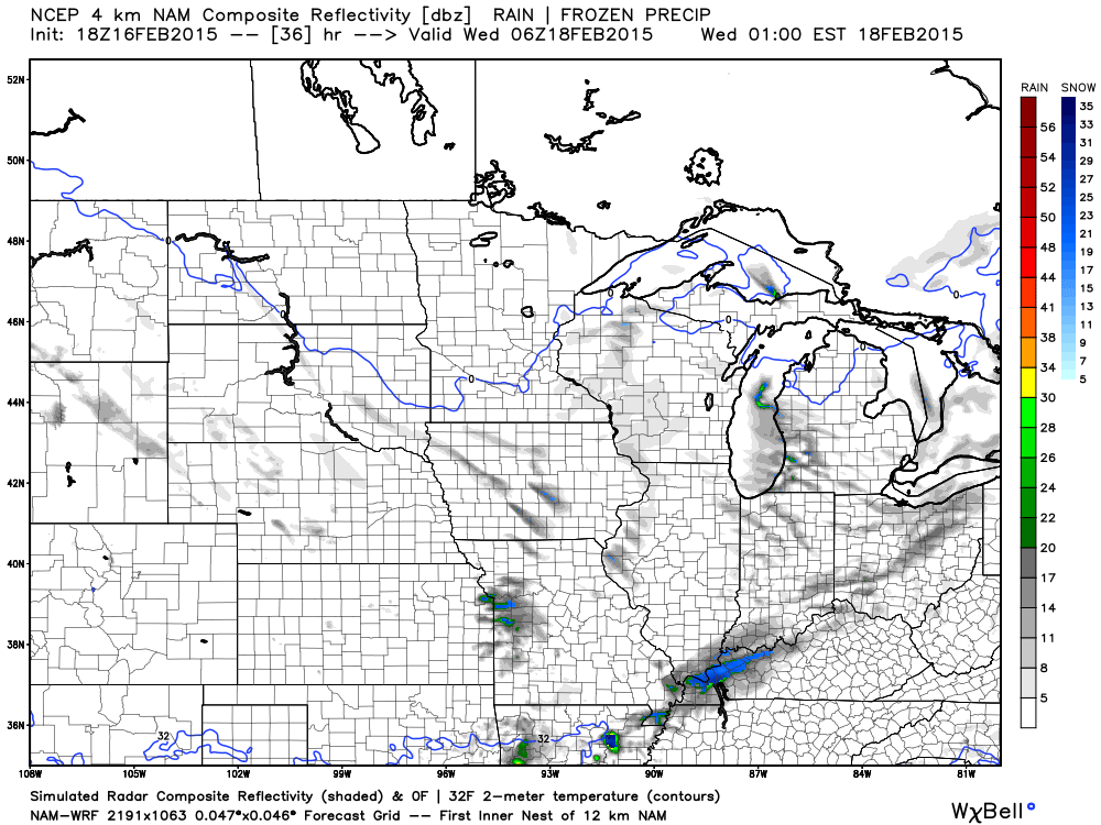
This is the Thursday evening radar.
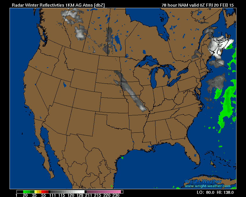
This is the radar for around 1 am on Friday morning
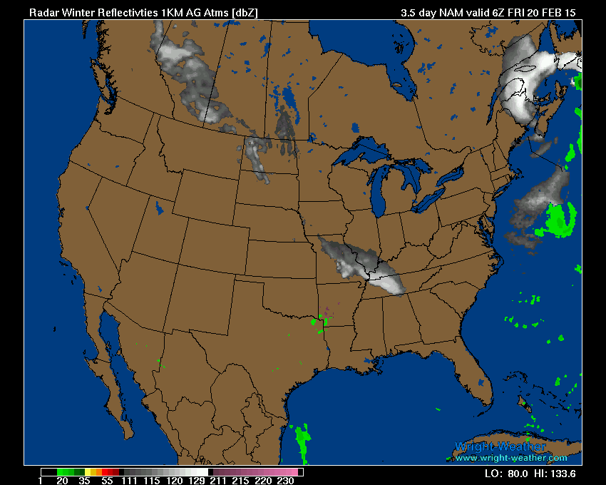
I will keep an eye on that little system. Sometimes these systems are stronger than forecast.
Read further down for information on what the GFS model is showing. It is showing a much larger system.
We have a new sponsor! G&C Multi-Services out of Paducah, Kentucky. G & C Multi-Services is a service provider in Western Kentucky that provides industrial and commercial equipment fabrication, machine troubleshooting, repair and maintenance, and installation. They can custom fabricate steel, stainless, and aluminum products per customer specifications.
Visit their web-site here. Or click the ad below! They have a Facebook page and it can be viewed here.

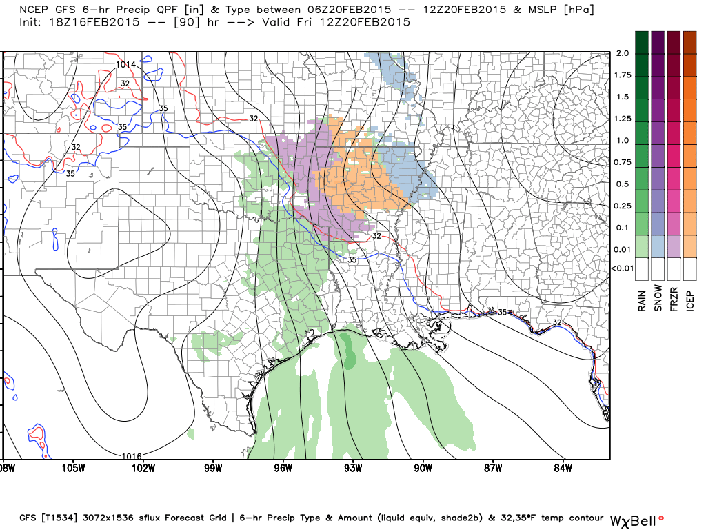
Now, that was the NAM model. But, there is disagreement on how this unfolds. The GFS model is developing a stronger system on Friday. Then multiple systems into the weekend and next week.
Stay with me – I am going to post some maps from the GFS model. You can see how it attempts to develop periods of widespread precipitation over the region.
This is a big concern because our snow isn’t going anywhere. Temperatures are going to be cold. If precipitation does develop then we may have to deal with ice and snow.
This may all come down to where the stationary front ends up. If the front is well south of us then that might help our cause. If it is draped over Arkansas and Tennessee then we might have problems.
There are questions as to how warm temperatures will be on Saturday. Will we be below freezing or above? That would make all the difference on precipitation type. Stay tuned!
Let me step you through the maps
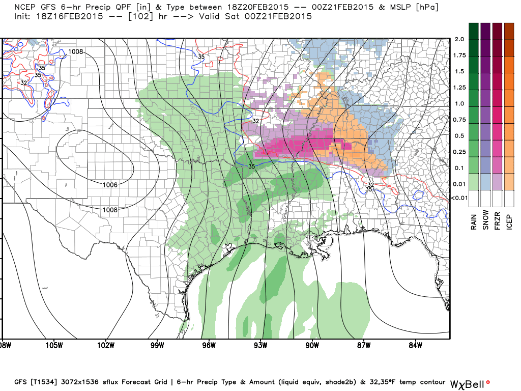
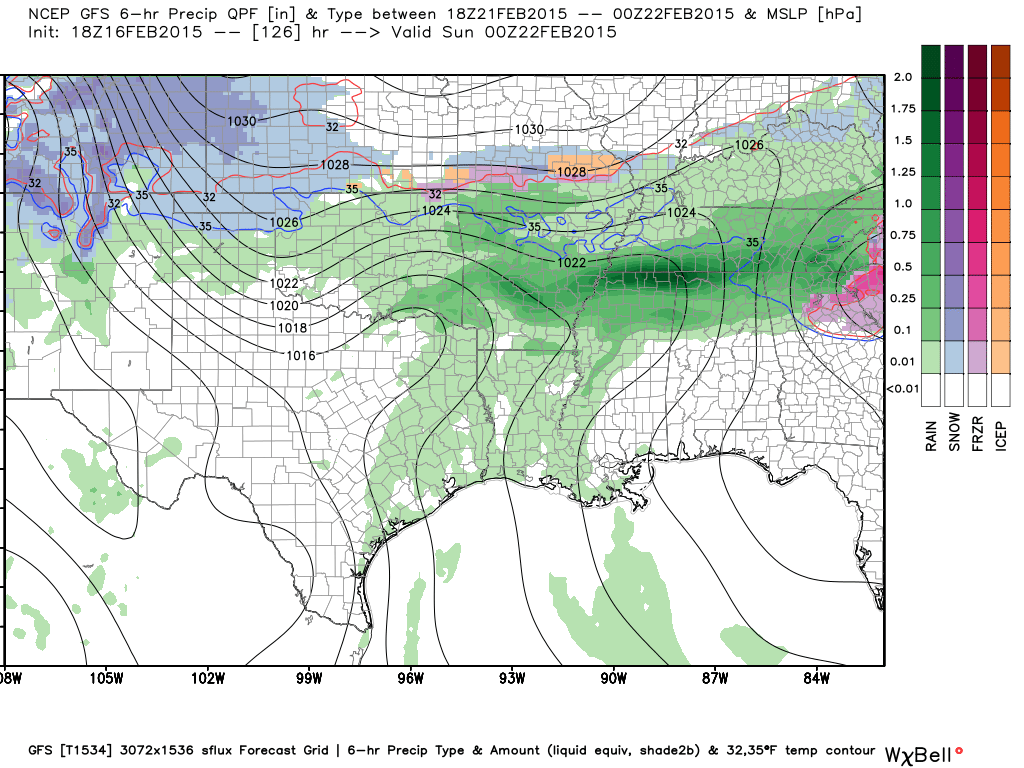
This is the map for Friday morning. You can see the snow in blue and then ice southwest of the blue. Moisture then develops and moves into our region. This will need to be monitored.
Images from www.weatherbell.com
This is the 12 pm map for Friday. You can see the precipitation over parts of our area.
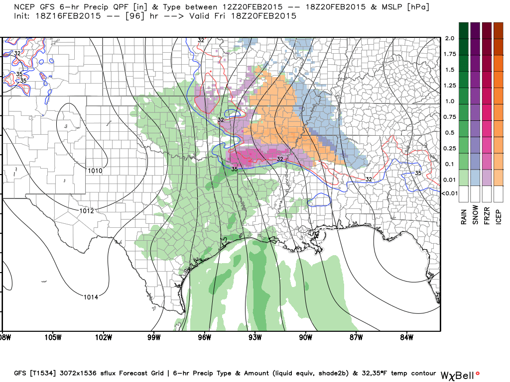
This is the Friday evening map. Scattered light frozen precipitation in the area.
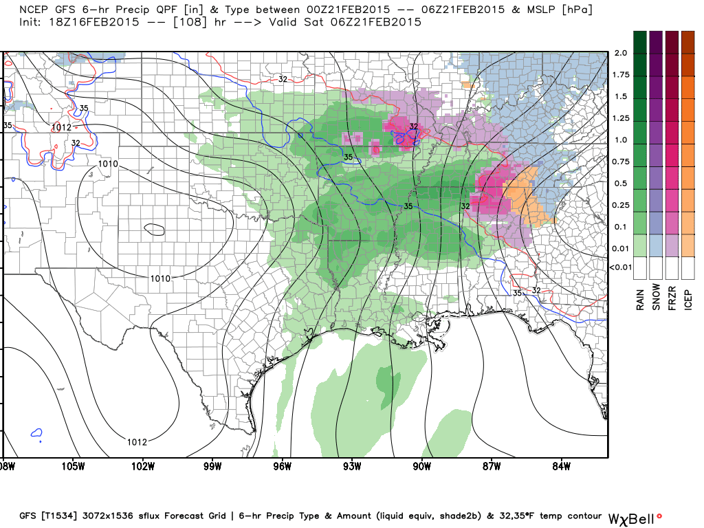
This is the map for Friday night. Scattered precipitation in and near our region.
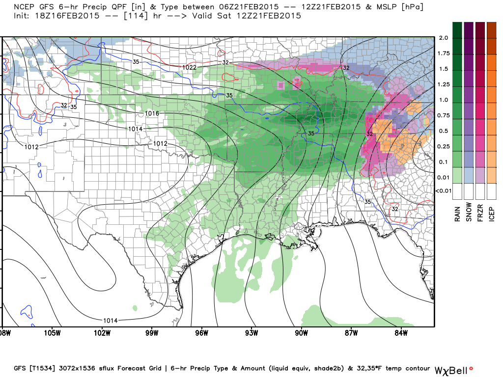
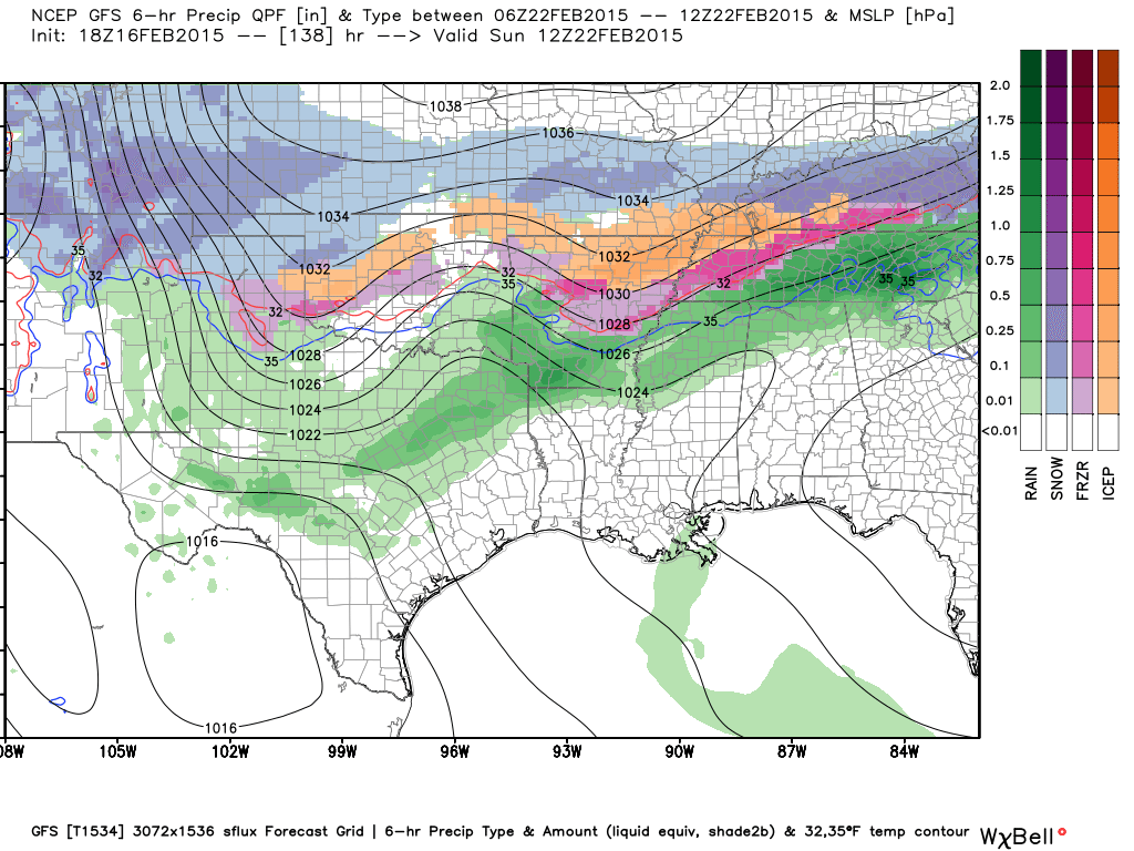
This is the Saturday morning. Widespread snow and ice in our region. This run is even showing some rain. I am skeptical about rain – with the deep snow pack in the region. Might be hard to get temperatures to rise much. We will see.
Again, this is the GFS models opinion. We still have a number of days to monitor this storm.
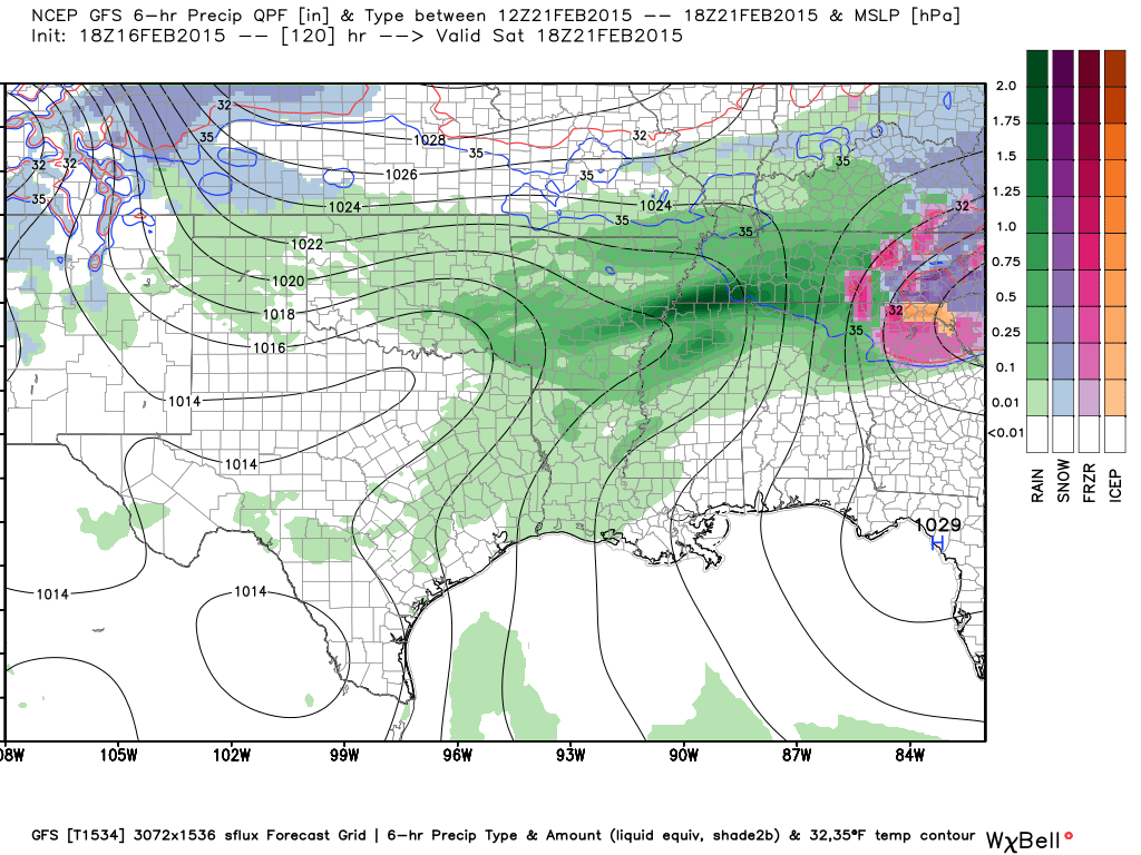
This is the Saturday afternoon map. Still precipitation in our region.
This is the Saturday night map. Precipitation continues.
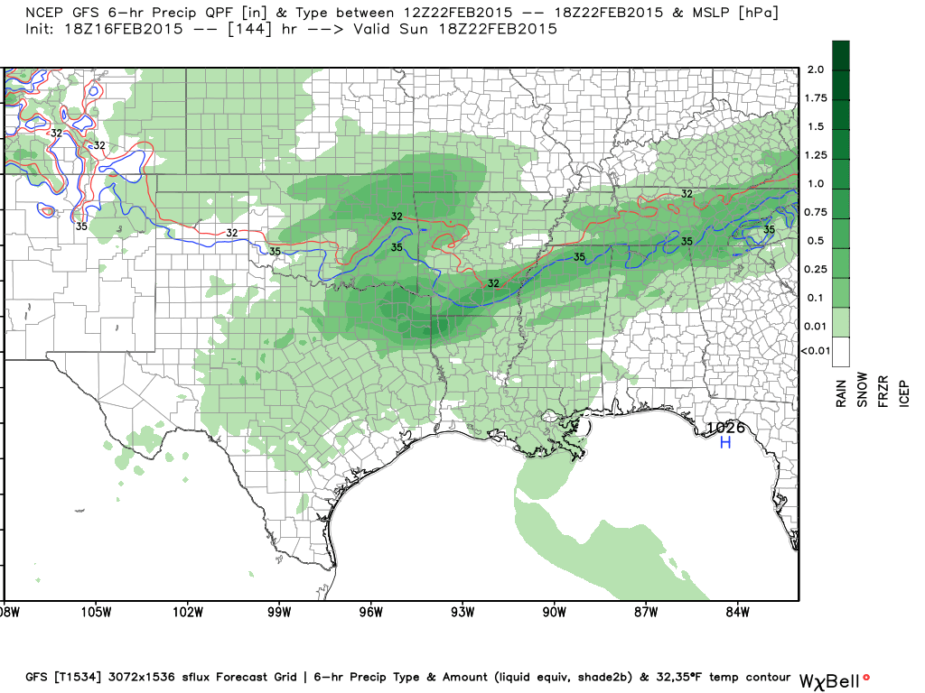
This is the Sunday morning map. Guess what the GFS is showing? Yes. Precipitation continues.
This is the Sunday afternoon map. Precipitation lull? Then more arrives after that.
Okay, so what does this mean?
It means we need to closely monitor forecasts over the coming days. A lot of the data is showing this system. I believe we are going to have to deal with some type of system from Friday into next week. Will that be to our south or over our local counties?
That is certainly one of the questions.

WANT TO HELP SUPPORT THIS BLOG AND COVER EXPENSES?
Did you know that the Weather Observatory is funded by people like you? I rely on ad’s on this blog and individual donations. PayPal also allows you to set up a monthly recurring donation. I have had several people give $5, $10, and $20 a month. A recurring donation helps keep the weather information flowing. If you enjoy this blog, the Twitter account, the Facebook interaction, the weather radars, and all of the other information then consider making a donation or setting up a recurring donation (if you don’t use PayPal then contact me through email about how you can mail a donation) beaudodson@usawx.com
Or mail a check to
Beau Dodson
3954 Mermet Road
Belknap, IL
62908
Thank you for your support!

Obvious concerns about hazardous driving conditions today and bitterly cold air over the coming days.
Some light snow possible tonight (Tuesday night).
The coldest temperatures arrive on Thursday morning. Temperatures will be well below zero. This could cause problems with some water pipes. Poorly protected pipes will freeze.
Car batteries will also not do well with this type of cold.
Check out our newest sponsors $5 meal! The DQ Grill and Chill (located across from Noble Park in Paducah, Kentucky) is the newest WeatherTalk Blog sponsor! A local business helping to sponsor the weather information that you have come to love so much.
They have a Facebook Page and I encourage you to check it out. DQ Grill and Chill on Facebook


Who do you trust for your weather information and who holds them accountable?
I have studied weather in our region since the late 1970’s. I have 37 years of experience in observing our regions weather patterns. My degree is in Broadcast Meteorology from Mississippi State University and an Associate of Science (AS). I am currently working on my Bachelor’s Degree in Geoscience. Just need to finish two Spanish classes!
I am a member of the American Meteorological Society. I am a NOAA Weather-Ready Nation Ambassador. And, I am the Meteorologist for McCracken County Emergency Management.
I own and operate the Southern Illinois Weather Observatory.
There is a lot of noise on the internet. A lot of weather maps are posted without explanation. Over time you should learn who to trust for your weather information.
My forecast philosophy is simple and straight forward.
- Communicate in simple terms
- To be as accurate as possible within a reasonable time frame before an event
- Interact with you on Twitter, Facebook, and the blog
- Minimize the “hype” that you might see on television or through other weather sources
- Push you towards utilizing wall-to-wall LOCAL TV coverage during severe weather events
I am a recipient of the Mark Trail Award, WPSD Six Who Make A Difference Award, Kentucky Colonel, and the Caesar J. Fiamma” Award from the American Red Cross. In 2009 I was presented with the Kentucky Office of Highway Safety Award. I was recognized by the Kentucky House of Representatives for my service to the State of Kentucky leading up to several winter storms and severe weather outbreaks.
If you click on the image below you can read the Kentucky House of Representatives Resolution.

I am also President of the Shadow Angel Foundation which serves portions of western Kentucky and southern Illinois.
We have regional radars and local city radars – if a radar does not seem to be updating then try another one. Occasional browsers need their cache cleared. You may also try restarting your browser. That usually fixes the problem. Occasionally we do have a radar go down. That is why I have duplicates. Thus, if one fails then try another one.
If you have any problems then please send me an email beaudodson@usawx.com
WEATHER RADAR PAGE – Click here —
We also have a new national interactive radar – you can view that radar by clicking here.
Local interactive city radars include St Louis, Mt Vernon, Evansville, Poplar Bluff, Cape Girardeau, Marion, Paducah, Hopkinsville, Memphis, Nashville, Dyersburg, and all of eastern Kentucky – these are interactive radars. Local city radars – click here
NOTE: Occasionally you will see ground clutter on the radar (these are false echoes). Normally they show up close to the radar sites – including Paducah.

Regional Radar – Click on radar to take you our full radar page.


Regional Radar
![]()
Current WARNINGS (a warning means take action now). Click on your county to drill down to the latest warning information. Keep in mind that there can be a 2-3 minute delay in the updated warning information.
I strongly encourage you to use a NOAA Weather Radio or warning cell phone app for the most up to date warning information. Nothing is faster than a NOAA weather radio.


Color shaded counties are under some type of watch, warning, advisory, or special weather statement. Click your county to view the latest information.

Illinois Warnings

Kentucky Warnings

Please visit your local National Weather Service Office by clicking here. The National Weather Service Office, for our region, is located in Paducah, Kentucky. They have a lot of maps and information on their site. Local people…local forecasters who care about our region.


Here is the official 6-10 day and 8-14 day temperature and precipitation outlook. Check the date stamp at the top of each image (so you understand the time frame).
The forecast maps below are issued by the Weather Prediction Center (NOAA).


The latest 8-14 day temperature and precipitation outlook. Note the dates are at the top of the image. These maps DO NOT tell you how high or low temperatures or precipitation will be. They simply give you the probability as to whether temperatures or precipitation will be above or below normal.


Many of my graphics are from www.weatherbell.com – a great resource for weather data, model data, and more


This blog was inspired by ABC 33/40’s Alabama Weather Blog – view their blog
Current tower cam view from the Weather Observatory- Click here for all cameras.

Southern Illinois Weather Observatory

The Weather Observatory

Southern Illinois Weather Observatory
WSIL TV 3 has a number of tower cameras. Click here for their tower camera page & Illinois Road Conditions

Marion, Illinois
WPSD TV 6 has a number of tower cameras. Click here for their tower camera page & Kentucky Road Conditions & Kentucky Highway and Interstate Cameras

Downtown Paducah, Kentucky
Benton, Kentucky Tower Camera – Click here for full view

Benton, Kentucky

I24 Paducah, Kentucky

I24 Mile Point 9 – Paducah, KY

I24 – Mile Point 3 Paducah, Kentucky

You can sign up for my AWARE email by clicking here I typically send out AWARE emails before severe weather, winter storms, or other active weather situations. I do not email watches or warnings. The emails are a basic “heads up” concerning incoming weather conditions.