3 PM
Winter storm watches and warnings now cover the area…click your county below for details.

2/19/15 Thursday – 2 pm update – sorry took me awhile to finish everything and send out an AWARE email. This is where I will start.
I will cut and paste you my AWARE email that was just sent out to about 3000 of you!
February 19, 2015:
New winter storm developing…
Forecast is for Friday into Saturday evening
My confidence in the verification of this forecast: Medium
This forecast continues to evolve. If you only read this forecast then that probably won’t cover the event. You should monitor the latest information as it becomes available via the National Weather Service or your trusted weather sources.
Type of event?
Snow, sleet, and freezing rain is in the forecast for a portion of Friday into Saturday morning.
Potential amounts?
1. Snow 1-2″ possible on Friday/Friday evening.
2. Sleet up to 1/2″ possible on Friday afternoon/night
3. Freezing rain (rain that falls from the sky and freezes instantly on all surfaces) of 0.10″ to 0.15″ possible on Friday night into Saturday morning – could be a bit more in spots (still uncertain about this part of the forecast)
4. Rain – thinking 1-2″ for most locations. Pockets of higher totals likely. I can’t rule out 3″+ amounts. Heaviest totals in Kentucky and Tennessee.
When?
Bulk of the precipitation falls on Friday night and Saturday. Some precipitation will fall on Friday morning into Friday afternoon – enough perhaps to cause some travel problems.
Impact?
Widespread hazardous travel will develop once snow and sleet begins.
Extremely dangerous driving conditions will develop once freezing rain begins. I am concerned about the freezing rain on roadways – the roads are very cold. Skating rink if freezing rain falls in this set-up.
Right now it does not look like enough freezing rain in far southern Illinois and western Kentucky to bring down large tree limbs or power lines. Normally that takes 0.30″ – 0.50″ of freezing rain. Monitor updated forecasts.
There is some data that keeps freezing rain longer over parts of southern Illinois – especially along a line from Carbondale to Harrisburg northward. Again, everyone should monitor the latest forecast.
There could be small tree limbs broken from the amount of ice being forecast. If the ice accumulation goes above 0.20″ then you usually see some small branches break. We could see some strong winds at times. Data showing spurts of 10-20 mph and gusty. This is an additional concern. Will have to monitor the wind forecast.
Certainties…
1. Patchy snow and sleet should develop on Friday from southwest to northeast
2. Frozen precipitation increases considerably (widespread) on Friday night
3. Frozen precipitation changes to rain on Saturday
4. Some flash flooding possible…especially in western Kentucky/Tennessee
Uncertainties…
1. Timing of precipitation on Friday – since it might be patchy in nature
2. What time does the freezing rain (rain that falls from the sky and freezes instantly on all surfaces) change to just plain old rain.
3. Rainfall amounts. Data has trended lower just a bit. But, still quite a bit of rain.
Time of development…
Patchy light snow may develop as early as tonight over southeast Missouri and spread into southern Illinois and western Kentucky on Friday. My confidence on the Friday part of this forecast is lower than usual (the 8 am to 4 pm time frame). I don’t think we see a solid shield of precipitation moving into the area. I think we see a lot of patchy light snow and sleet.
Either way the focus is on impact and not amounts. Roads are VERY cold. Temperatures this morning were in the -5 to -20 range over our region. Incredible numbers and historic in nature.
Any precipitation that falls on Friday/Friday night will stick to roadways.
Precipitation will become widespread on Friday night. Unfortunately, temperatures aloft will warm considerably on Friday night. That means the snow and sleet will melt as it falls through the warm layer. Temperatures at the surface will be well below freezing. This means freezing rain…glaze of ice.
Right now freezing rain totals are forecast to be in the 0.10″-0.15″ range. That is enough to perhaps break some small limbs. It is not enough to break power lines. The biggest concern will be roadways.
When freezing rain falls onto these cold roadways you are going to see a skating rink develop. Extremely hazardous driving conditions will be an issue once freezing rain develops. This could keep first responders busy, please don’t add to their problems. Stay off the roadways.
What time will the freezing rain develop?
Snow and sleet will transition to freezing rain on Friday evening over southeast Missouri and northwest Tennessee. It will then spread northeast into Illinois and Kentucky.
I am not sure on the exact time for each location. It will start over our southwest counties first. It will then spread northeast.
If you have travel plans on Friday afternoon and especially on Friday night, then you need to monitor updates or perhaps think about changing your plans.
Cars and freezing rain do not go together. A glaze of ice on roadways will spell bad news for everyone involved. First responders will be busy if this forecast verifies.
The highest death toll from weather comes from these types of winter storms. Please use care during this event.
On Saturday, temperatures should rise above freezing over far southern Illinois and western Kentucky/Tennessee. Again, the timing of the temperatures rising above 32 degrees will need to be monitored.
The latest data has all trended colder for this event. That raises some concern as to what time the freezing rain comes to an end. I don’t like the trends in the data. It slows the warmer air arrival time.
With that said, I still think the areas I forecast for will rise above freezing. Areas further east in Kentucky need to closely monitor the updated forecasts, as well. This is going to be a high impact event for the State of Kentucky – travel wise.
This brings me to the next concern – flooding.
A deep snow pack covers much of the region. Rain falling on ice covered snow and snow will immediately run off.
Let’s say we have a solid sheet of ice on top of the snow (because of the sleet and/or freezing rain). Where do you think the water is going to go when it rains? Especially if temperatures are mostly in the 30’s during this event. Immediate run-off.
Rain falling onto roofs, that have deep snow cover, will be an issue, as well. Large span roofs could collapse if they have deep snow on them and then heavy rain develops.
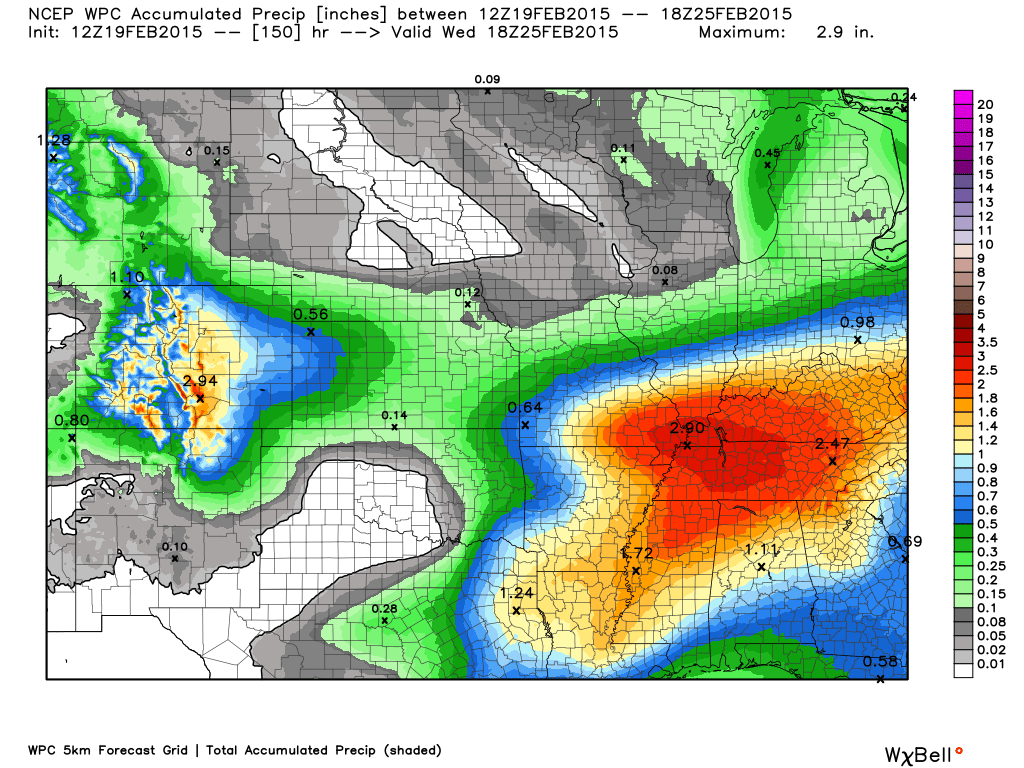
Ice and snow have covered many storm drains. Flooding is very likely if this moderate to heavy develops. I am concerned for some of our counties. The heaviest totals may be over far southern Illinois and western Kentucky. I can’t rule out some 3″ totals. 1-2″ seems likely. Locally heavier in pockets.
– Meteorologist Beau Dodson
9 AM
New data coming in this morning – they are all trending colder. This is going to mess up my forecast.
Monitor for updates
8 AM Update
I have added probability maps for rain and snow below. Also some updated maps. See them within the post.
We have our first sponsor for the blog. Milner and Orr Funeral Home and Cremation Services located in Paducah, Kentucky and three other western Kentucky towns – at Milner and Orr they believe in families helping families.
![]()

This forecast update covers far southern Illinois, far southeast Missouri, and far western Kentucky. See the coverage map on the right side of the blog.
Remember that weather evolves. Check back frequently for updates, especially during active weather.
Thursday – Sunny and very cold. Highs only around 10-14 degrees. Light northwest winds. Wind chills in the morning of 0 to -10 degrees. My confidence in this part of the forecast verifying is high
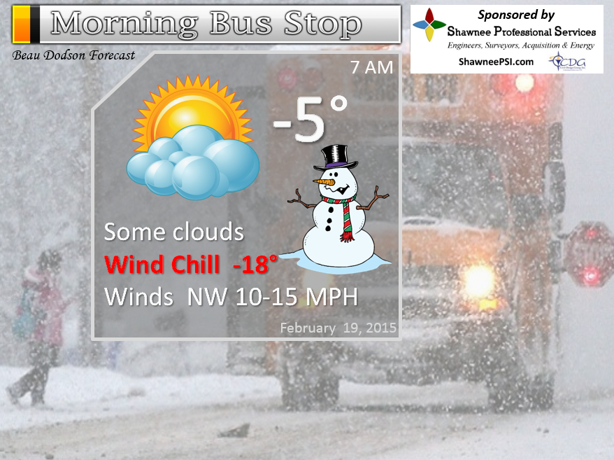
Morning School Bus Stop Weather – Partly cloudy and cold. Morning temperatures below zero. Light northwest winds at 5 mph. Wind chills below zero.
—————————————————————————————-
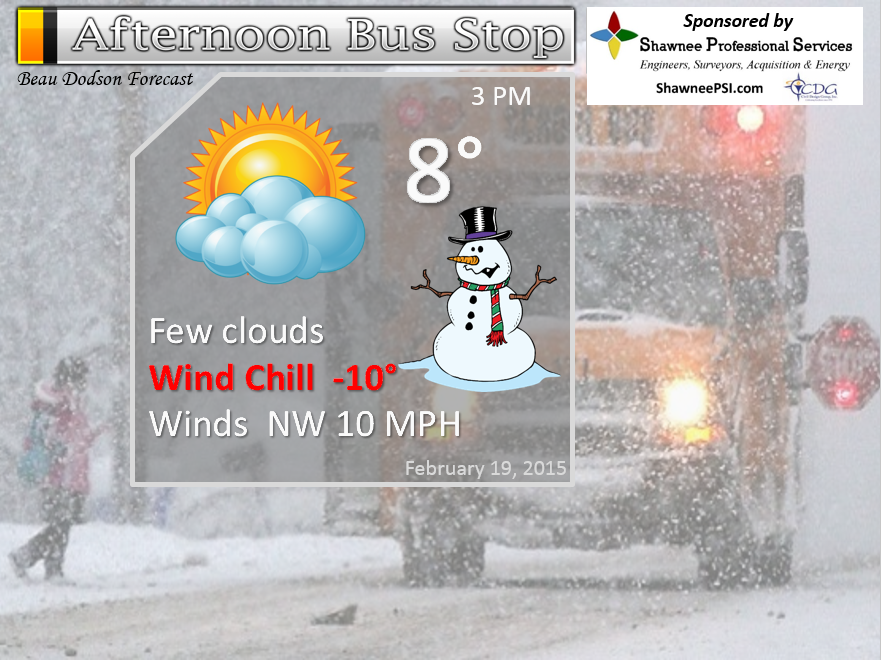
Afternoon School Bus Stop Weather – Partly cloudy and cold. Temperatures only in the 6 to 12 degree range. Light northwest winds at 5 mph. Wind chills below zero.
Thursday night – Becoming cloudy with a chance for a light snow shower late. Low temperatures around 4 to 8 degrees. East winds at 5 mph. My confidence in this part of the forecast verifying is high
Friday – Cloudy with a scattered chance of snow during the morning over southeast Missouri. A medium chance for light snow and sleet developing over the rest of the area by Friday afternoon. Any accumulation will be light. Hazardous driving conditions developing. Highs from 25 to 30 degrees. Southeast winds at 10-15 mph. My confidence in this part of the forecast verifying is medium.
Friday night – A period of freezing rain, sleet, and snow. Light accumulations possible of snow and sleet. Freezing rain might accumulate to 0.10″ Power lines break usually with 0.50″ of freezing rain, thus this does not look to be a severe ice storm. But, some accumulation of freezing rain will occur. Freezing rain MAY change to rain after midnight. Hazardous driving conditions. Temperatures rising through the night. Southeast winds at 5-10 mph. My confidence in this part of the forecast verifying is high.
Saturday – Freezing rain changing to rain. A risk for some flash flooding. Temperatures rising into the middle 30’s to lower 40’s. My confidence in this part of the forecast verifying is LOW.
Further analysis and details below…

The School Bus Stop Forecast is brought to your by Shawnee Professional Services. For more information click here

Shawnee Professional Services & Civil Design Group have been providing Land Surveying, Engineering, Grant Administration and Acquisition services for the past 20 years.
Currently Licensed in Illinois, Kentucky, Missouri, Indiana, and Tennessee; please contact Shawnee for any Land Surveying or Engineering needs.
Shawnee’s company size allows them to devote individual attention to each client and to approach each project with the required thoroughness to successfully complete the project, large or small.
Shawnee combines innovative thinking and proven techniques, completing projects cost-effectively for their clients. Visit Shawnee’s website at shawneepsi.com for more information. Shawnee has offices in Paducah, KY, Vienna, IL and Benton, IL.
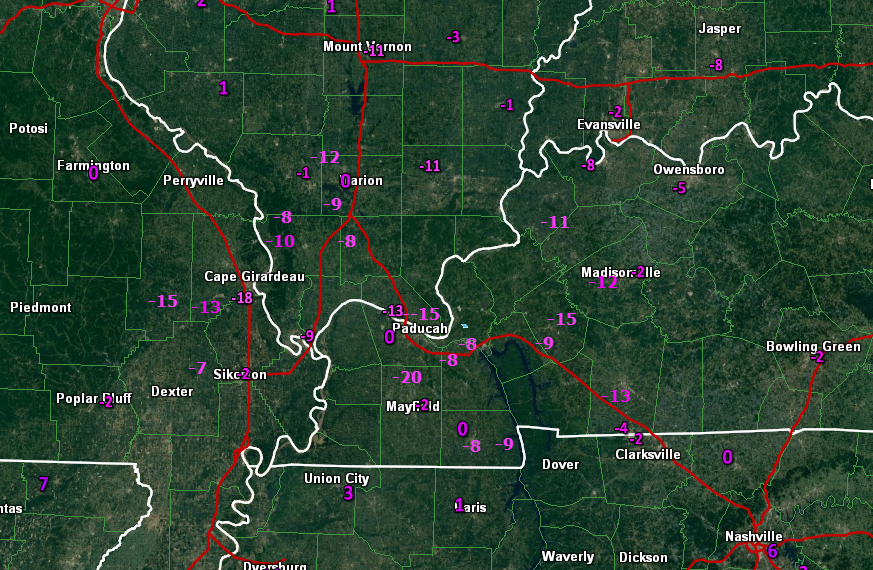
Current Temperatures Around The Local Area


An explanation of what is happening in the atmosphere over the coming days…
Brrrr – good chilly Thursday morning. Very cold around the region. But, I don’t have to tell you that.
Some readings
-18 in Cape Girardeau, MO (a few people scoffed when I said some spots might go below -10)
-11 Mt Vernon, IL
-13 Massac County, IL
-11 Harrisburg, IL
Folks, you might not see readings like this for a very long time.
Click map for a full view
Speaking of cold air. I busted badly on my temperature forecast for Wednesday afternoon. I had temperatures falling into the single digits over southern Illinois by sunset. Mt Vernon fell to 9 degrees. Everyone else was in the 11 to 16 degree range. Missed it by several degrees. I thought the cold air would arrive a bit earlier. Oh well, I am guessing you are not complaining?
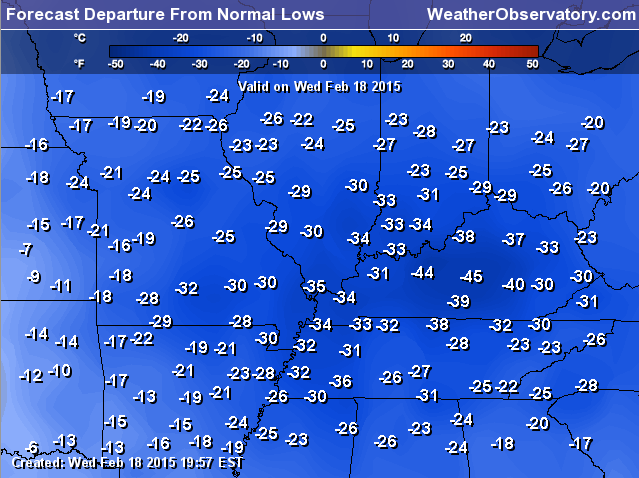
Look at these INSANE departure numbers.
These are not real temperatures. These numbers represent how many degrees above or below normal temperatures are.
These are the departures for this Thursday morning (low temps). How many degrees below normal are temperatures this morning? Well, here you go. Incredible numbers.
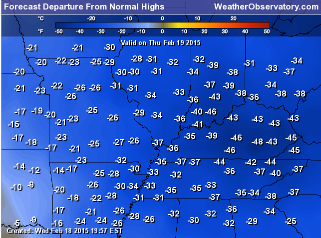
Departures for highs on Thursday. Yes, there are some places that will be more than 40 degrees BELOW normal. You don’t see this very often.
We have a new winter storm to track and it moves into the region over the next 24 hours. The good news is that snow, sleet, and freezing rain totals will be light. The bad news is that road conditions will be very slick for awhile on Friday and Friday night.
Here are the current watches and warnings – more will be issued. To read your local warnings click the image and then drill down to your county.
IS THERE GOING TO BE A MAJOR ICE STORM IN OUR REGION FRIDAY NIGHT AND SATURDAY?
NO. Only light freezing rain totals are forecast. Yes, some freezing rain will fall. But, major impacts to trees and power lines are not in the forecast. SLICK ROADS will be the problem.
Freezing rain (rain that falls from the sky and immediately freezes on trees, power lines, and other surfaces) should only accumulate around 0.10″. This is not enough to cause power lines to fall or anything like that. You need to see freezing rain totals of 0.25″ or greater to start having problems with tree limbs. Normally 0.50″ of freezing rain accumulation can cause problems with power lines. The freezing rain is forecast for Friday night and early Saturday morning.
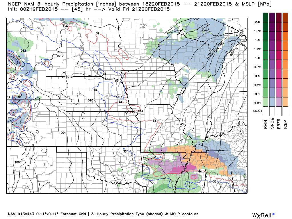
Let’s look at the NAM model future-cast radar. What the weather map might look like on Friday into Friday night. You can see the areas of precipitation represented by the colors. Blue is snow, orange would be sleet, pink/red would be freezing rain, and rain is green.
These images are from www.weatherbell.com
This is the future-cast radar for later this evening – around 9 pm. That gray area represents a little bit of flurry or light snow shower activity. Not a big deal.
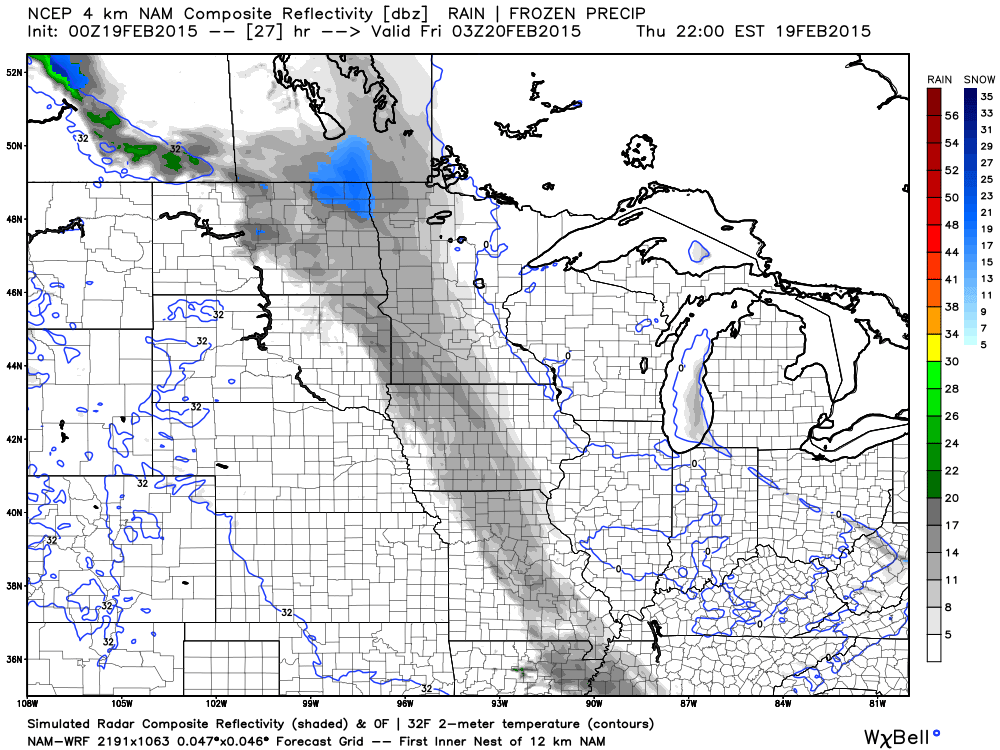
This is the future-cast radar for Friday morning around 6 am. Some light snow showers possible. Nothing major and many areas might not see anything at all.
This is the future-cast radar around 12 pm on Friday. Light snow and sleet in the area. Again, light. Any precipitation though will stick and will cause roadways to become slick and hazardous. We will have to wait and see just how widespread precipitation ends up being on Friday.
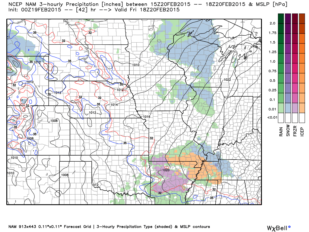
This is the future-cast radar for around 3 pm Friday afternoon. Again, you can see precipitation in the area.
The good news is that temperatures will rise above freezing by early Saturday morning! As a matter of fact, I think all of the snow may melt on Saturday. What? Yep! Well, sure there may be some rain left in the parking lots (pretty big piles out there) – but everywhere else…should melt.
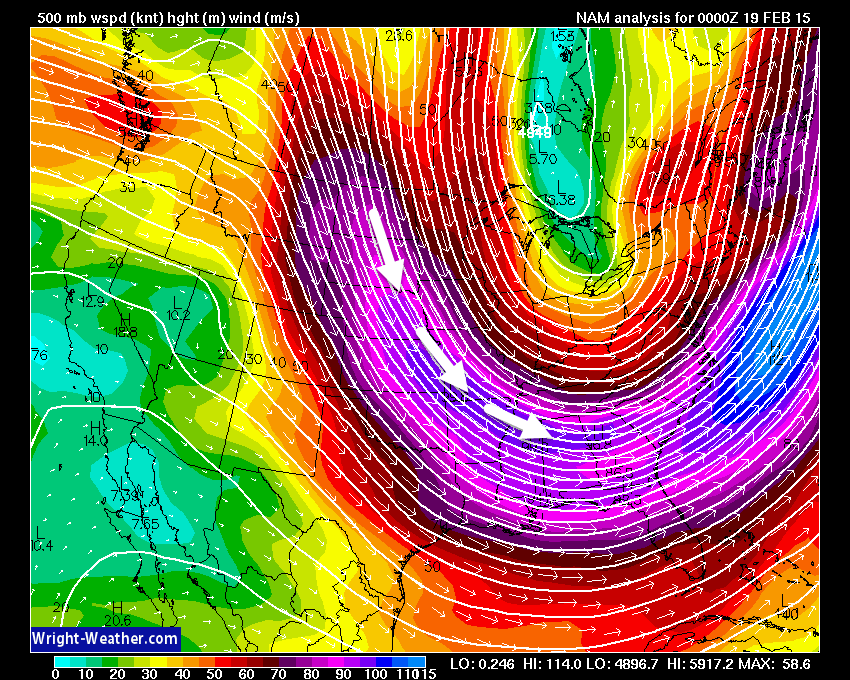
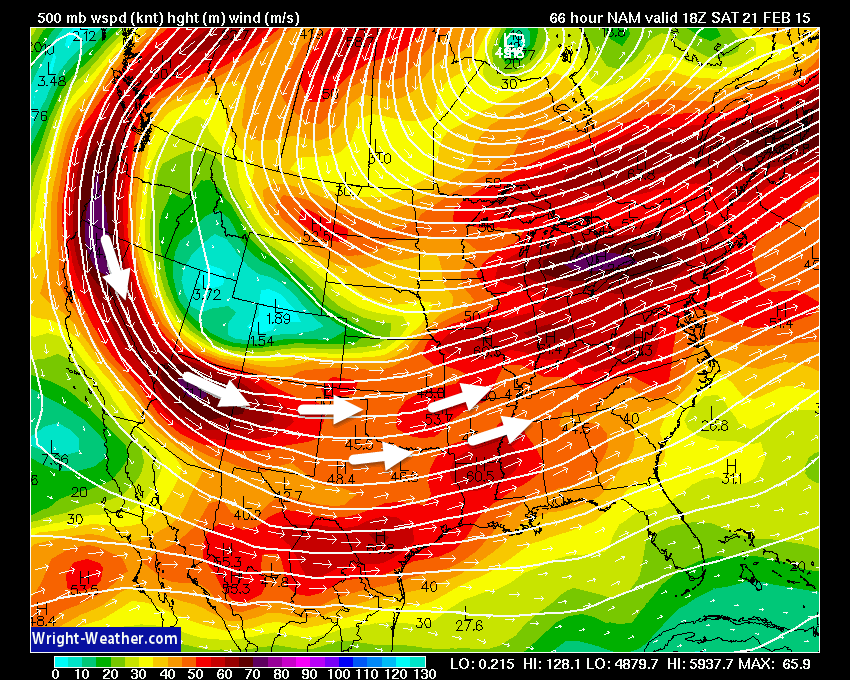
Check out the jet stream today – what direction is the wind coming from? Northwest! Yes. That means COLD air diving out of Canada. STRONG jet. Can’t hardly see our region because of all the colors.

Now, let’s look at Saturday’s jet stream. What direction is the wind coming from? Yes. Southwest flow! That means a ton of moisture. Lot of rain is in the forecast for Saturday. Let’s be thankful it isn’t freezing rain. I guess there is always a silver lining.
Moderate to heavy rain arrives on Friday. This is going to cause some flooding problems.
Let’s break this all down…
Temperatures today will be cold with highs only reading into the lower single digits – some counties may not get out of the single digits.
Clouds increase tonight as an area of lift develops over Missouri. Some light snow or sleet may break out over the area by Friday morning. The snow and sleet will increase in coverage on Friday and Friday evening. Right now it appears amounts will be minimal. The problem is that roads are very cold. Any snow or sleet that falls will stick.
To make matters worse, warm air aloft will move into the region on Friday night. This is going to change the snow and sleet to freezing rain. Extremely hazardous road conditions will develop once this happens.
Anyone with travel plans on Friday night should monitor updates and road conditions. Could be some very hazardous road conditions for awhile.
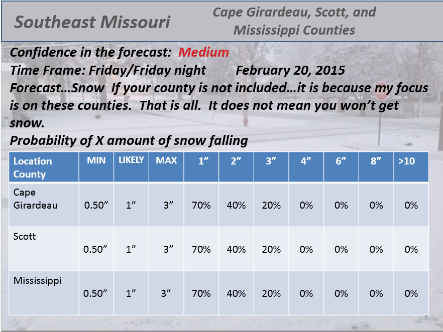
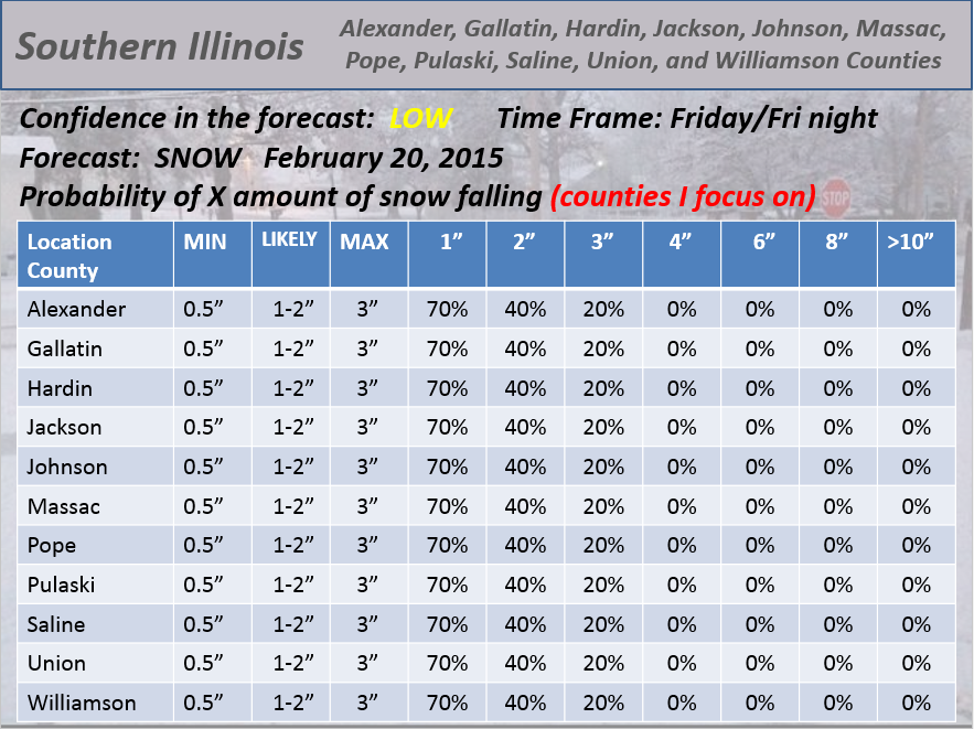
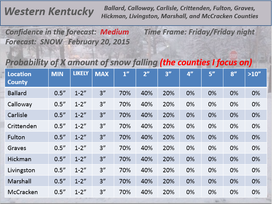
Here are my hand made snowfall probability forecasts. What is the % chance of X amount of snow falling in your county (if you county is not on this map it isn’t because you may not receive snow. I can only do so many counties. If you are near one of these counties (to the east of one of them) then your numbers would be close or the same.
I am forecasting temperatures to rise above freezing on Saturday morning. What time? Well, that depends on where you are in the area. Temperatures will rise above freezing over far southeast Missouri and western Kentucky first. The 32 line will then move northeast from there. All of my forecast counties will be above freezing by mid or late morning.
NOW – there is new data rolling in that shows Saturday staying colder than previously thought. If true then I will need to update numbers.
Some decent rainfall totals likely in the region on Saturday. Heaviest over southern counties.
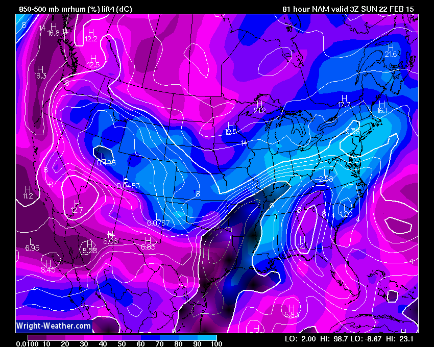
This is the lift index for Friday evening from wright-weather.com That dark area over our counties…that represents an unstable atmosphere. A few heavy thunderstorms will be possible. Gusty winds and small hail are possible with the most intense cells. This will enhance rainfall in some areas. Blah – what other word is there for this weather pattern? Active.
Best chance of thunder would be along the KY/TN line and down into Tennessee. Part of this will depend on if the warmer air verifies.
Frozen ground and a deep snow pack is going to make this a mess. Water will not soak into the ground, obviously.
Heavy weight on large span roofs…
Large span roofs may have problems if they have deep snow on them. All that snow on top of roofs with rain falling on top will increase the weight of the snow SUBSTANTIALLY. This is a problem.
There may be a flood or flash flood watch issued on Saturday.
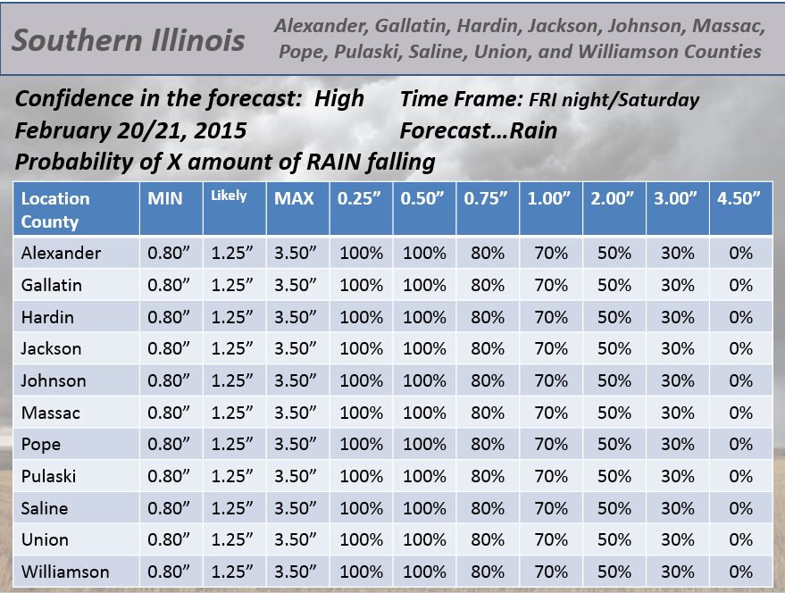
Here are my hand made probability maps for the RAIN part of the system – NOTE THIS IS THE RAIN probabilities (not snow)

I am not expecting any severe thunderstorms. Some good news.
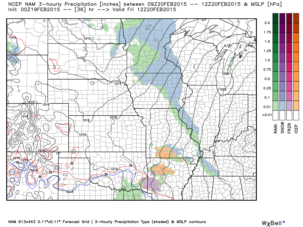
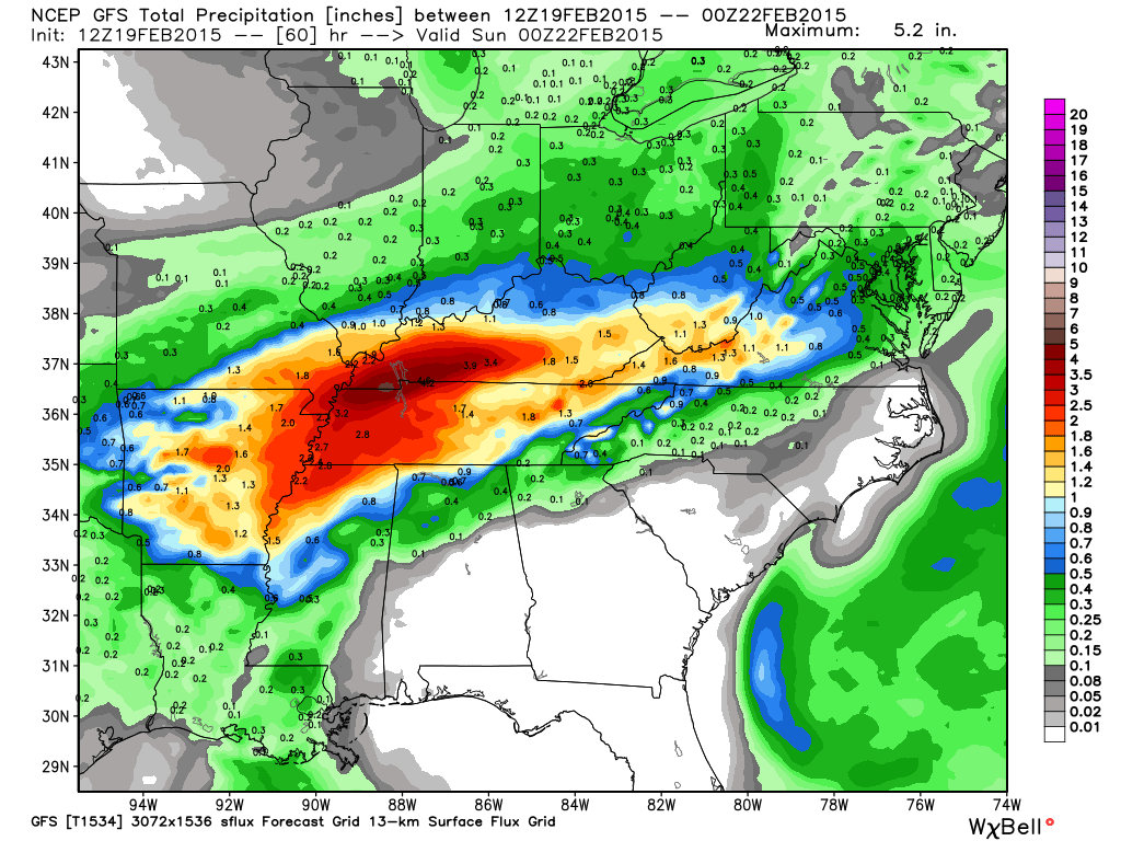
Let’s look at a couple of model data points. This is the GFS model. This is how much rain it is forecasting for Saturday. You should be able to see the state outlines on the map.
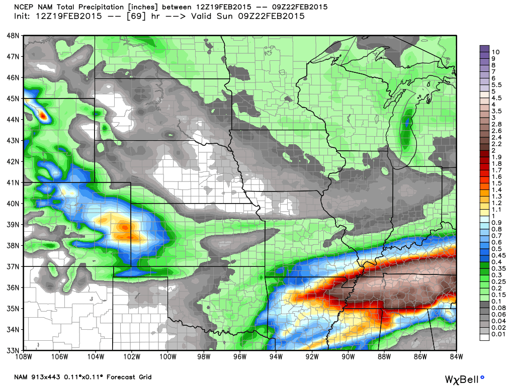
This is what the NAM model is forecasting for rainfall totals. Heavy rains – moderate rains. The morning data is shifting things southward a bit.
Colder temperatures arrive on Saturday night. Any rain left over will change to a period of light snow and sleet. Light accumulations possible.
Real mess over the coming days.
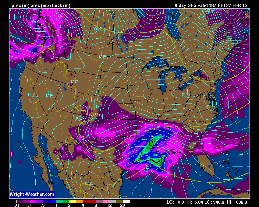
I am watching another storm next week – another southern track system.
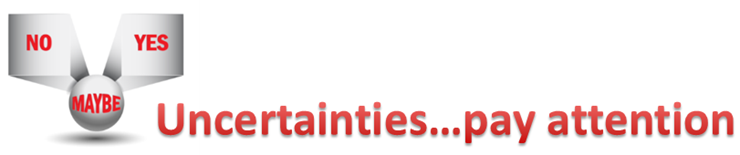
The uncertainties part of the e-journal spells out where I am not confident in the forecast. I always tell people to pay attention to the whole forecast and not just the part they want to hear.
Lot of uncertainties about what time the freezing rain will change over to plain old rain on Saturday. I am thinking after midnight for far southeast Missouri and western Kentucky. Perhaps between 12 am and 4 am. I am thinking a bit later for southern Illinois, but not much later.
Questions now opening up about Saturday’s temperatures. Will it be as warm as previously thought? New morning data says Saturday will stay cold. This is a concern.
MONITOR UPDATES

WANT TO HELP SUPPORT THIS BLOG AND COVER EXPENSES?
Did you know that the Weather Observatory is funded by people like you? I rely on ad’s on this blog and individual donations. PayPal also allows you to set up a monthly recurring donation. I have had several people give $5, $10, and $20 a month. A recurring donation helps keep the weather information flowing. If you enjoy this blog, the Twitter account, the Facebook interaction, the weather radars, and all of the other information then consider making a donation or setting up a recurring donation (if you don’t use PayPal then contact me through email about how you can mail a donation) beaudodson@usawx.com
Or mail a check to
Beau Dodson
3954 Mermet Road
Belknap, IL
62908
Thank you for your support!

No major changes to my ongoing forecast thoughts. Adjusted temperatures slightly.

Hazardous road conditions developing on Friday – probably mostly afternoon into evening.
Some ice accumulation on Friday night. Looking at 0.10″ to maybe 0.30″. This will depend on how fast the freezing rain changes to plain old rain. But, some ice likely. Nothing major or catastrophic by any means.
Heavy rain with flash flood potential on Saturday. Rainfall totals of 1-3″ with possibility of 3″ or more in spots.
Wintry mix redeveloping Saturday night and Sunday morning. Right now it appears light totals.
Check out our newest sponsors $5 meal! The DQ Grill and Chill (located across from Noble Park in Paducah, Kentucky) is the newest WeatherTalk Blog sponsor! A local business helping to sponsor the weather information that you have come to love so much.
They have a Facebook Page and I encourage you to check it out. DQ Grill and Chill on Facebook


The wild card tells you where the uncertainties are in the forecast
Wild card in this forecast – the wild card for the next 24 hours will be what time the snow and sleet develops late tonight or more likely for most of us on Friday. Maybe some in the morning, but thinking more afternoon.

Can we expect severe thunderstorms over the next 24 to 48 hours? Remember that a severe thunderstorm is defined as a thunderstorm that produces 58 mph winds or higher, quarter size hail or larger, and/or a tornado.
Thunderstorm threat level is ZERO for Thursday, but will be ONE for Saturday. Thunderstorms possible. Not expecting severe thunderstorms, but some could produce strong winds and small hail (Saturday)


Will I need to take action? Yes!
Bitterly cold air again tonight with single digit lows.
Slick roads may develop on Friday, again. This will last until at least late Friday night and probably early morning Saturday. A little uncertain on the exact timing of the precipitation on Friday. Monitor updates and radars.
Heavy rain on Saturday could cause the weight on large flat span roofs to increase dramatically. Heavy snow pack combined with the weight of the rain? Could be some roof problems for some.
Flash flooding possible on Saturday IF the heavy rain does develop. Thinking 1-2 inches of rain for the region. Locally higher.

How much precipitation should we expect over the next few days?
Do we ever have precipitation! A lot of precipitation is going to fall over the coming days. Several inches of rain possible on top of the snow and sleet/ice. Messy.
This is the official rainfall total forecast from the Weather Prediction Center (NOAA). These totals give you a good idea of what to expect. Of course rainfall is never uniform across an area. It will vary. But, you get the idea – lot of rain coming to the region.

Snow and sleet for Friday into Friday night. Wintry mix changes over to freezing rain on Friday night and early Saturday morning. Some ice accumulation on trees will be possible. Thinking right now is 0.10″-0.15″. That is not a lot of freezing rain. To break power lines you need around 0.50″ of freezing rain. So, this is a whole lot less than that.
Monitor updates
A winter storm warning or winter weather advisory will need to be issued on Friday into Friday night. Already a winter storm watch has been issued in west Tennessee.
Jim Rasor has a new blog. Check it out when you have time http://mylocalweather.net/forum/home

This section of the blog is speculative forecast information. Because it is past the range of what meteorologists can forecast accurately, it should be considered speculation. Anything past day 5 is considered a long range forecast.
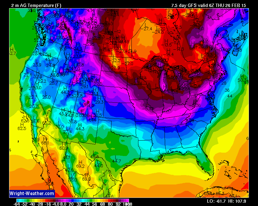
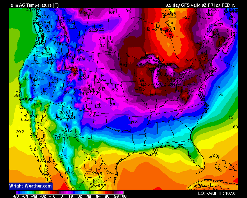
Bitterly cold air next week into the following week. The cold does not want to let up.
A very large system is forecast to develop in Texas next week and move east. Whether this system will impact our region is questionable. Let’s keep an eye on it. Looks big for someone.
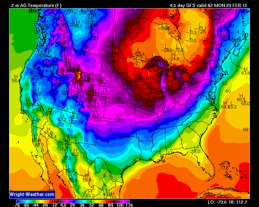
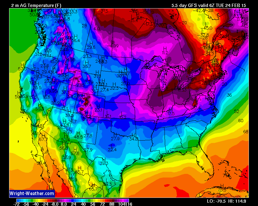
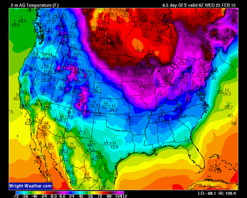
Let’s look at what temperatures will be at midnight each night – next week. These are not even the low temperatures. Ack – the cold just will not let up.
Some hints of mild weather the first week of March. We shall see.
Images from www.wright-weather.com Click image for larger view.
Midnight temperatures for Sunday night (below)
Scale is at the bottom of each image.
Temperatures for next Monday night (below)
Temperatures for next Tuesday night (below)
Temperatures for next Wednesday night (below)
Temperatures for next Thursday night. (below)
Here is that system next week – late week. Let’s just keep an eye on it. LONG way off.

Who do you trust for your weather information and who holds them accountable?
I have studied weather in our region since the late 1970’s. I have 37 years of experience in observing our regions weather patterns. My degree is in Broadcast Meteorology from Mississippi State University and an Associate of Science (AS). I am currently working on my Bachelor’s Degree in Geoscience. Just need to finish two Spanish classes!
I am a member of the American Meteorological Society. I am a NOAA Weather-Ready Nation Ambassador. And, I am the Meteorologist for McCracken County Emergency Management.
I own and operate the Southern Illinois Weather Observatory.
There is a lot of noise on the internet. A lot of weather maps are posted without explanation. Over time you should learn who to trust for your weather information.
My forecast philosophy is simple and straight forward.
- Communicate in simple terms
- To be as accurate as possible within a reasonable time frame before an event
- Interact with you on Twitter, Facebook, and the blog
- Minimize the “hype” that you might see on television or through other weather sources
- Push you towards utilizing wall-to-wall LOCAL TV coverage during severe weather events
I am a recipient of the Mark Trail Award, WPSD Six Who Make A Difference Award, Kentucky Colonel, and the Caesar J. Fiamma” Award from the American Red Cross. In 2009 I was presented with the Kentucky Office of Highway Safety Award. I was recognized by the Kentucky House of Representatives for my service to the State of Kentucky leading up to several winter storms and severe weather outbreaks.
If you click on the image below you can read the Kentucky House of Representatives Resolution.

I am also President of the Shadow Angel Foundation which serves portions of western Kentucky and southern Illinois.

We have regional radars and local city radars – if a radar does not seem to be updating then try another one. Occasional browsers need their cache cleared. You may also try restarting your browser. That usually fixes the problem. Occasionally we do have a radar go down. That is why I have duplicates. Thus, if one fails then try another one.
If you have any problems then please send me an email beaudodson@usawx.com
WEATHER RADAR PAGE – Click here —
We also have a new national interactive radar – you can view that radar by clicking here.
Local interactive city radars include St Louis, Mt Vernon, Evansville, Poplar Bluff, Cape Girardeau, Marion, Paducah, Hopkinsville, Memphis, Nashville, Dyersburg, and all of eastern Kentucky – these are interactive radars. Local city radars – click here
NOTE: Occasionally you will see ground clutter on the radar (these are false echoes). Normally they show up close to the radar sites – including Paducah.

Regional Radar – Click on radar to take you our full radar page.


Regional Radar
![]()
Current WARNINGS (a warning means take action now). Click on your county to drill down to the latest warning information. Keep in mind that there can be a 2-3 minute delay in the updated warning information.
I strongly encourage you to use a NOAA Weather Radio or warning cell phone app for the most up to date warning information. Nothing is faster than a NOAA weather radio.


Color shaded counties are under some type of watch, warning, advisory, or special weather statement. Click your county to view the latest information.

Missouri Warnings

Illinois Warnings

Kentucky Warnings

Please visit your local National Weather Service Office by clicking here. The National Weather Service Office, for our region, is located in Paducah, Kentucky. They have a lot of maps and information on their site. Local people…local forecasters who care about our region.


Here is the official 6-10 day and 8-14 day temperature and precipitation outlook. Check the date stamp at the top of each image (so you understand the time frame).
The forecast maps below are issued by the Weather Prediction Center (NOAA).


The latest 8-14 day temperature and precipitation outlook. Note the dates are at the top of the image. These maps DO NOT tell you how high or low temperatures or precipitation will be. They simply give you the probability as to whether temperatures or precipitation will be above or below normal.


Many of my graphics are from www.weatherbell.com – a great resource for weather data, model data, and more


This blog was inspired by ABC 33/40’s Alabama Weather Blog – view their blog
Current tower cam view from the Weather Observatory- Click here for all cameras.

Southern Illinois Weather Observatory

The Weather Observatory

Southern Illinois Weather Observatory
WSIL TV 3 has a number of tower cameras. Click here for their tower camera page & Illinois Road Conditions

Marion, Illinois
WPSD TV 6 has a number of tower cameras. Click here for their tower camera page & Kentucky Road Conditions & Kentucky Highway and Interstate Cameras

Downtown Paducah, Kentucky
Benton, Kentucky Tower Camera – Click here for full view

Benton, Kentucky

I24 Paducah, Kentucky

I24 Mile Point 9 – Paducah, KY

I24 – Mile Point 3 Paducah, Kentucky

You can sign up for my AWARE email by clicking here I typically send out AWARE emails before severe weather, winter storms, or other active weather situations. I do not email watches or warnings. The emails are a basic “heads up” concerning incoming weather conditions.