UPDATE 10 AM
Looks like snow totals are going to be on the high end of my probability table. Widespread reports of 8″ or more over the area. Parts of Massac County are nearing a foot. Impressive snow. Bands of heavier totals in my forecast counties – a stripe of 9-12″ across far southern IL and parts of west KY.
Snow will continue for a few more hours. Tapering as we move forward.
VERY VERY COLD air this week. I can not place enough emphasis on the potential for record cold.
My forecast lows for this week
Tuesday morning 8 above to 5 below
Wednesday morning 5 above to 5 below
Thursday morning 2 above to 10 below (yes 10 below is on the table)
This type of cold will put a strain on the electric grid and pipes. This will be an expensive cold outbreak.
Watching more precipitation chances Friday into next week. STAY TUNED!
Radars are up and running – see storm tracking links below
Click for large view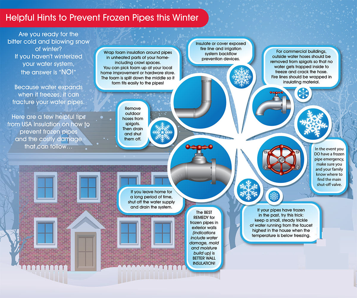
We have our first sponsor for the blog. Milner and Orr Funeral Home and Cremation Services located in Paducah, Kentucky and three other western Kentucky towns – at Milner and Orr they believe in families helping families.
![]()

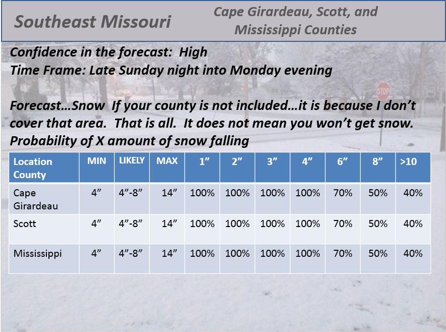
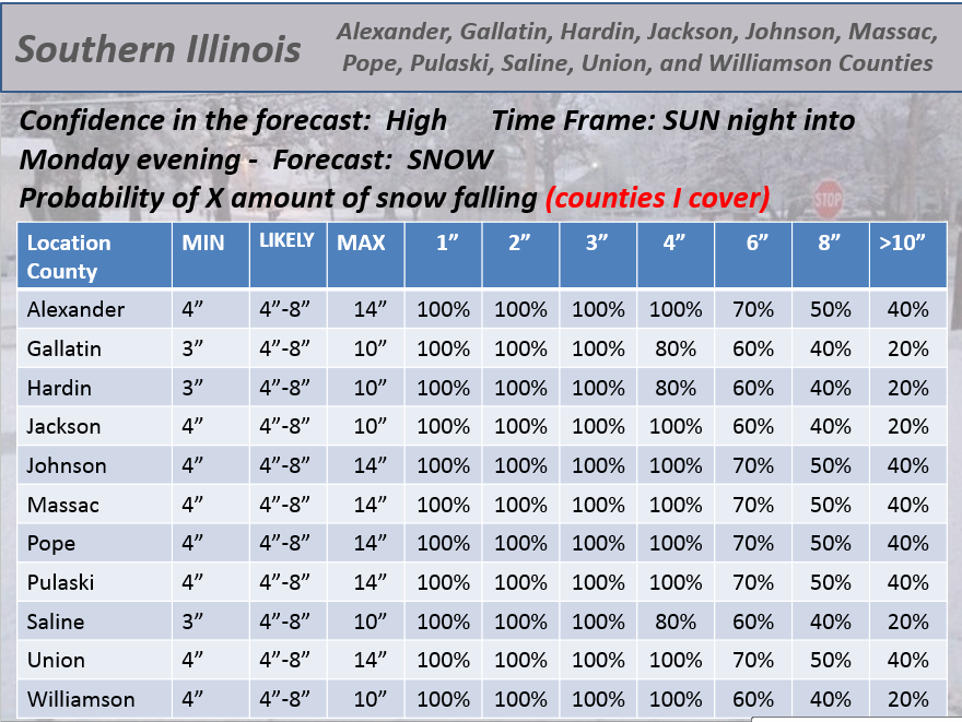
This forecast update covers far southern Illinois, far southeast Missouri, and far western Kentucky. See the coverage map on the right side of the blog.
Remember that weather evolves. Check back frequently for updates, especially during active weather.
I will update the blog from time to time today (top of the page)
I WILL UPDATE AS NEW INFORMATION BECOMES AVAILABLE – I WILL ALSO KEEP THE FACEBOOK PAGE UPDATED FREQUENTLY
Monday – Snow continuing. Snow may be mixed with sleet near the KY/TN line. Several inches of accumulation will occur today (see my numbers down below in the discussion). Cold – temperatures in the teens and 20’s. North/northeast winds at 5-15 mph. My confidence in this part of the forecast verifying is medium
Monday night – Partly cloudy – maybe early evening flurries or light snow. Cold. Lows in the 8-14 degree range. Colder in spots where snow is deeper. North winds at 10-15 mph – winds becoming west late. My confidence in this part of the forecast verifying is high
Tuesday – Cloudy. High temperatures in the lower to middle 20’s. Variable winds at 5-10 mph. My confidence in this part of the forecast verifying is high.
Tuesday night – Clearing. Cold. Lows in the 5-15 degree range. West winds becoming northwest towards morning at 10-15 mph. My confidence in this part of the forecast verifying is high
Wednesday – Becoming cloudy Chance for flurries or a snow shower. Windy at times. Highs in the 20’s and then falling into the teens by afternoon. Perhaps even colder in spots. Winds becoming north at 10-25 mph with gusts above 30 mph. My confidence in this part of the forecast verifying is medium
Bitterly cold Thursday morning with lows below zero.

CLICK YOUR COUNTY FOR WATCH AND WARNING INFORMATION FROM THE NATIONAL WEATHER SERVICE

Color shaded counties are under some type of watch, warning, advisory, or special weather statement. Click your county to view the latest information.


An explanation of what is happening in the atmosphere over the coming days…
Good morning. Let’s get right into it.
It was a long day on Sunday forecasting the event, updating maps, updating different social media sites, and answering your questions on Facebook! Record number of questions? Definitely ranks up there!
Pretty tired here tonight – going on 1 am. I plan on getting up early to cover the storm. Here is a brief update and some storm tracking tools.
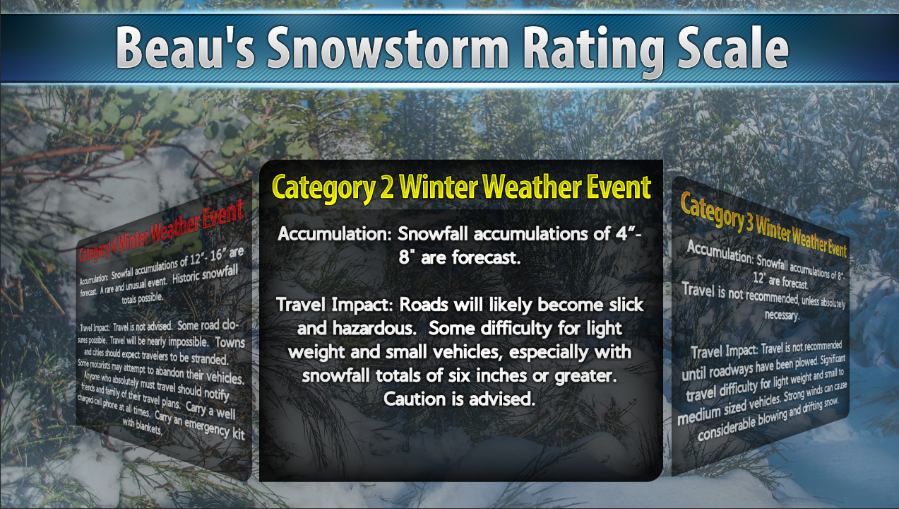
No changes in my forecast from yesterday’s late morning update. Category 2 winter storm continues over the area. As always there will be surprises in this winter event. Someone will walk away with more snow than others. Banding is generally the reason for that.
Thought about going with category 3 winter storm. That would mean widespread 8-12 inch totals. We will see how it goes. Either way, slick roads are the biggest issue with little not much wind. Thus, no real threat for widespread blowing and drifting snow.
Still, even while the snow is underway there remain some questions on banding. That always will throw a forecast off.
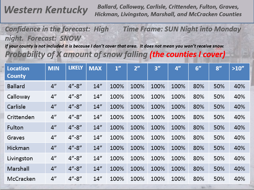
I have not changed my probabilities. I will post them again below. Same probabilities that I had yesterday.
I stuck with widespread 4-8 inch forecast totals. I leaned towards the 6-8″ range and mentioned higher totals likely in some areas.
We will see how the final numbers pan out in my forecast counties. I will post verification when it is all finished. Again, there will always be spots that end up with more than forecast.
There are many concerns over the coming days.
The obvious concern will be hazardous road conditions right on through the end of the week. Bitterly cold air will be the general rule. The coldest temperatures arrive on Wednesday and Thursday.
We may see single digits on Tuesday and Wednesday morning. Below zero on Thursday.
We will likely break records on Thursday morning. Below zero readings.
Temperatures that cold will mean broken water pipes for some. Please let everyone know. People who had problems during past cold spells could have problems again. It could also be a pull on the power grid. Especially true since it is cold across much of the eastern United States.
Some light snow possible on Wednesday. Not expecting much. Watching another system late week. Too soon to even think about predictions on that event.
Check out one of our sponsors for the blog – they help keep the data flowing. G&C Multi-Services out of Paducah, Kentucky. G & C Multi-Services is a service provider in Western Kentucky that provides industrial and commercial equipment fabrication, machine troubleshooting, repair and maintenance, and installation. They can custom fabricate steel, stainless, and aluminum products per customer specifications.
Visit their web-site here. Or click the ad below! They have a Facebook page and it can be viewed here.


WANT TO HELP SUPPORT THIS BLOG AND COVER EXPENSES?
Did you know that the Weather Observatory is funded by people like you? I rely on ad’s on this blog and individual donations. PayPal also allows you to set up a monthly recurring donation. I have had several people give $5, $10, and $20 a month. A recurring donation helps keep the weather information flowing. If you enjoy this blog, the Twitter account, the Facebook interaction, the weather radars, and all of the other information then consider making a donation or setting up a recurring donation (if you don’t use PayPal then contact me through email about how you can mail a donation) beaudodson@usawx.com
Or mail a check to
Beau Dodson
3954 Mermet Road
Belknap, IL
62908
Thank you for your support!

I am guessing you have figured out my concerns today. Use care if you must be out and about. Snow will continue into the afternoon hours. Snow will end west to east.
I am quite concerned about the forecast lows for Thursday morning. Below zero readings are likely in the area. Bitterly cold.
Check out our newest sponsors $5 meal! The DQ Grill and Chill (located across from Noble Park in Paducah, Kentucky) is the newest WeatherTalk Blog sponsor! A local business helping to sponsor the weather information that you have come to love so much.
They have a Facebook Page and I encourage you to check it out. DQ Grill and Chill on Facebook


We have regional radars and local city radars – if a radar does not seem to be updating then try another one. Occasional browsers need their cache cleared. You may also try restarting your browser. That usually fixes the problem. Occasionally we do have a radar go down. That is why I have duplicates. Thus, if one fails then try another one.
If you have any problems then please send me an email beaudodson@usawx.com
WEATHER RADAR PAGE – Click here —
We also have a new national interactive radar – you can view that radar by clicking here.
Local interactive city radars include St Louis, Mt Vernon, Evansville, Poplar Bluff, Cape Girardeau, Marion, Paducah, Hopkinsville, Memphis, Nashville, Dyersburg, and all of eastern Kentucky – these are interactive radars. Local city radars – click here
NOTE: Occasionally you will see ground clutter on the radar (these are false echoes). Normally they show up close to the radar sites – including Paducah.

Regional Radar – Click on radar to take you our full radar page.


Regional Radar

Will I need to take action?
That probably goes without saying today. Winter storm will continue into the early afternoon hours.
You might need to think about preparing for VERY cold temperatures by Thursday morning. Below zero readings. Keep this in mind.

Who do you trust for your weather information and who holds them accountable?
I have studied weather in our region since the late 1970’s. I have 37 years of experience in observing our regions weather patterns. My degree is in Broadcast Meteorology from Mississippi State University and an Associate of Science (AS). I am currently working on my Bachelor’s Degree in Geoscience. Just need to finish two Spanish classes!
I am a member of the American Meteorological Society. I am a NOAA Weather-Ready Nation Ambassador. And, I am the Meteorologist for McCracken County Emergency Management.
I own and operate the Southern Illinois Weather Observatory.
There is a lot of noise on the internet. A lot of weather maps are posted without explanation. Over time you should learn who to trust for your weather information.
My forecast philosophy is simple and straight forward.
- Communicate in simple terms
- To be as accurate as possible within a reasonable time frame before an event
- Interact with you on Twitter, Facebook, and the blog
- Minimize the “hype” that you might see on television or through other weather sources
- Push you towards utilizing wall-to-wall LOCAL TV coverage during severe weather events
I am a recipient of the Mark Trail Award, WPSD Six Who Make A Difference Award, Kentucky Colonel, and the Caesar J. Fiamma” Award from the American Red Cross. In 2009 I was presented with the Kentucky Office of Highway Safety Award. I was recognized by the Kentucky House of Representatives for my service to the State of Kentucky leading up to several winter storms and severe weather outbreaks.
If you click on the image below you can read the Kentucky House of Representatives Resolution.

I am also President of the Shadow Angel Foundation which serves portions of western Kentucky and southern Illinois.
![]()
Current WARNINGS (a warning means take action now). Click on your county to drill down to the latest warning information. Keep in mind that there can be a 2-3 minute delay in the updated warning information.
I strongly encourage you to use a NOAA Weather Radio or warning cell phone app for the most up to date warning information. Nothing is faster than a NOAA weather radio.


Color shaded counties are under some type of watch, warning, advisory, or special weather statement. Click your county to view the latest information.

Missouri Warnings

Illinois Warnings
Kentucky Warnings

Please visit your local National Weather Service Office by clicking here. The National Weather Service Office, for our region, is located in Paducah, Kentucky. They have a lot of maps and information on their site. Local people…local forecasters who care about our region.

Here is the official 6-10 day and 8-14 day temperature and precipitation outlook. Check the date stamp at the top of each image (so you understand the time frame).
The forecast maps below are issued by the Weather Prediction Center (NOAA).


The latest 8-14 day temperature and precipitation outlook. Note the dates are at the top of the image. These maps DO NOT tell you how high or low temperatures or precipitation will be. They simply give you the probability as to whether temperatures or precipitation will be above or below normal.

Many of my graphics are from www.weatherbell.com – a great resource for weather data, model data, and more


This blog was inspired by ABC 33/40’s Alabama Weather Blog – view their blog
Current tower cam view from the Weather Observatory- Click here for all cameras.

Southern Illinois Weather Observatory

The Weather Observatory

Southern Illinois Weather Observatory
WSIL TV 3 has a number of tower cameras. Click here for their tower camera page & Illinois Road Conditions

Marion, Illinois
WPSD TV 6 has a number of tower cameras. Click here for their tower camera page & Kentucky Road Conditions & Kentucky Highway and Interstate Cameras

Downtown Paducah, Kentucky
Benton, Kentucky Tower Camera – Click here for full view

Benton, Kentucky

I24 Paducah, Kentucky

I24 Mile Point 9 – Paducah, KY

I24 – Mile Point 3 Paducah, Kentucky

You can sign up for my AWARE email by clicking here I typically send out AWARE emails before severe weather, winter storms, or other active weather situations. I do not email watches or warnings. The emails are a basic “heads up” concerning incoming weather conditions.