We have some great sponsors for the Weather Talk Blog. Please let our sponsors know that you appreciate their support for the Weather Talk Blog.
Milner and Orr Funeral Home and Cremation Services located in Paducah, Kentucky and three other western Kentucky towns – at Milner and Orr they believe in families helping families. You can find Milner and Orr on Facebook, as well.
![]()
.

Wortham Dental Care located in Paducah, Kentucky. The gentle dentist. Mercury free dentistry. They also do safe Mercury removal. You can find Wortham Dental Care on Facebook, as well
.

For all of your families eye care needs. Visit their web-site here. Or, you can also visit their Facebook page.
.

Endrizzi’s Storm Shelters – For more information click here. Endrizzi Contracting and Landscaping can be found on Facebook, as well – click here
.

Best at Enabling Body Shop Profitability since 1996. Located In Paducah Kentucky and Evansville Indiana; serving all customers in between. They provide Customer Service, along with all the tools necessary for body shops to remain educated and competitive. Click the logo above for their main web-site. You can find McClintock Preferred Finishes on Facebook, as well
.

Duck/goose decoys? Game calls? Optics? We have you covered! Click the logo above or visit Final Flight on Facebook, as well.

This forecast update covers far southern Illinois, far southeast Missouri, and far western Kentucky. See the coverage map on the right side of the blog.
Remember that weather evolves. Check back frequently for updates, especially during active weather.
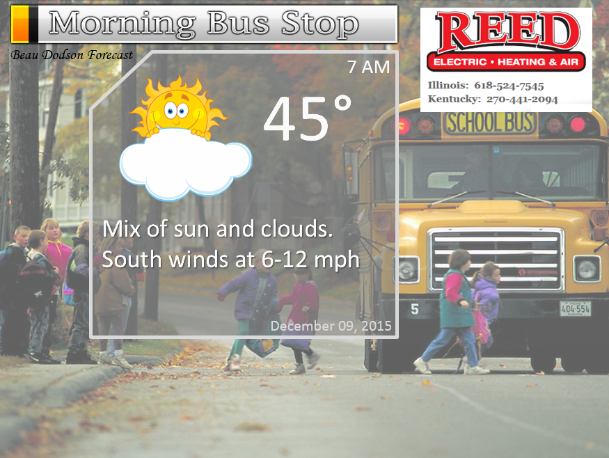
Tuesday night – Partly to mostly cloudy and cool. A sprinkle possible.
Temperatures: Lows in the middle 40s.
Winds: South winds at 6-12 mph. Winds becoming southwest at 6-12 mph.
What is the chance for precipitation? 20%
Coverage of precipitation? Isolated
My confidence in this part of the forecast verifying is High
Should I be concerned about snow or ice? No
Should I cancel my outdoor plans? No
Is severe weather expected? No
What impact is expected? None
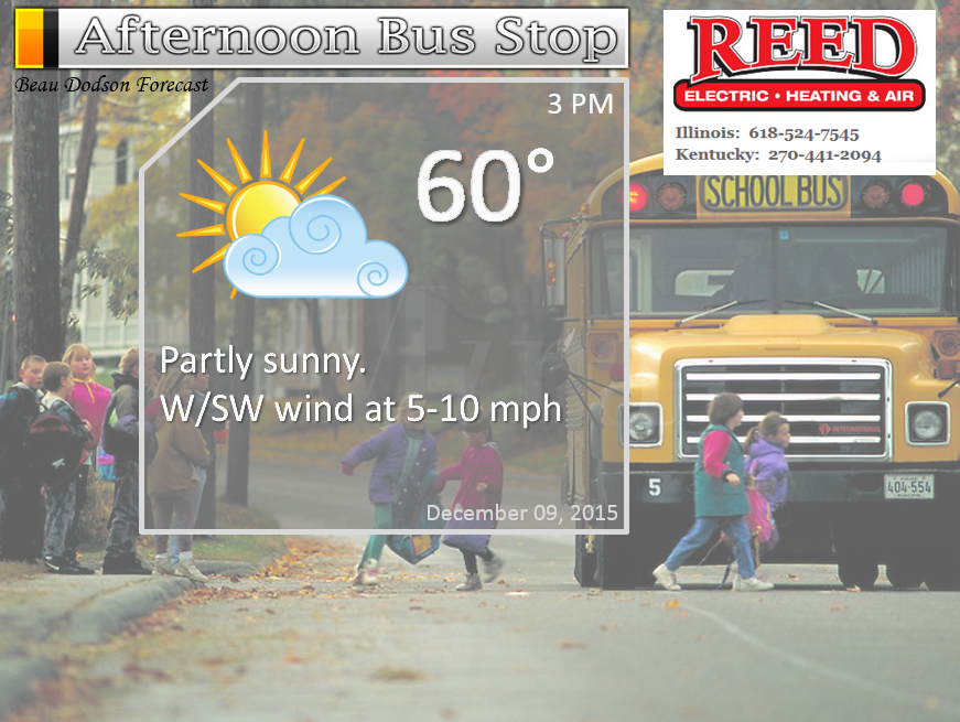
Wednesday – Morning clouds. Decreasing clouds through the morning and afternoon. Mild. Not too bad for December temperature wise. Isolated sprinkle possible before 5 am.
Temperatures: Highs in the upper 50s to middle 60s.
Winds: West/southwest winds at 5-10 mph.
What is the chance for precipitation? 10% before 5 am
Coverage of precipitation? Isolated
My confidence in this part of the forecast verifying is High
Should I be concerned about snow or ice? No
Should I cancel my outdoor plans? No
Is severe weather expected? No
What impact is expected? None
Wednesday night – Partly cloudy and cool. Not too bad for December.
Temperatures: Lows in the lower to middle 40s
Winds: South and southwest winds at 5-10 mph.
What is the chance for precipitation? 0%
Coverage of precipitation? None
My confidence in this part of the forecast verifying is High
Should I be concerned about snow or ice? No
Should I cancel my outdoor plans? No
Is severe weather expected? No
What impact is expected? None
Thursday – Partly cloudy. Mild for December.
Temperatures: Highs in the lower 60s
Winds: Southwest winds at 5-10 mph with gusts to 15 mph
What is the chance for precipitation? 0%
Coverage of precipitation? None
My confidence in this part of the forecast verifying is High
Should I be concerned about snow or ice? No
Should I cancel my outdoor plans? No
Is severe weather expected? No
What impact is expected? None
Thursday night – Partly cloudy.
Temperatures: Lows in the middle to upper 40s
Winds: South and southwest winds at 5-10 mph. Gusts to 15 mph.
What is the chance for precipitation? 10%
Coverage of precipitation? None
My confidence in this part of the forecast verifying is High
Should I be concerned about snow or ice? No
Should I cancel my outdoor plans? No
Is severe weather expected? No
What impact is expected? None
Friday – Partly sunny. A 20% chance for a shower.
Temperatures: Highs in the middle to upper 60s
Winds: South winds at 6-12 mph with gusts to 20 mph
What is the chance for precipitation? 20%
Coverage of precipitation? Isolated
My confidence in this part of the forecast verifying is Medium
Should I be concerned about snow or ice? No
Should I cancel my outdoor plans? No
Is severe weather expected? No
What impact is expected? None
Friday night – Partly cloudy. A chance for an isolated shower.
Temperatures: Lows in the middle to upper 50s
Winds: South at 6-12 mph with gusts to 15 mph
What is the chance for precipitation? 20%
Coverage of precipitation? Isolated
My confidence in this part of the forecast verifying is Medium
Should I be concerned about snow or ice? No
Should I cancel my outdoor plans? No
Is severe weather expected? No
What impact is expected? None
Saturday – A mix of sun and clouds. Mild. A chance for a shower. Maybe a thunderstorm (low confidence on thunderstorm chances)
Temperatures: Highs in the middle to upper 60s
Winds: Southeast winds at 10-20 mph. Gusty winds.
What is the chance for precipitation? 30%
Coverage of precipitation? Scattered
My confidence in this part of the forecast verifying is High
Should I be concerned about snow or ice? No
Should I cancel my outdoor plans? No
Is severe weather expected? No
What impact is expected? Wet roadways. Will need to monitor for thunderstorm chances.
Saturday night – Cloudy. A chance for showers and thunderstorms. Locally heavy rain possible.
Temperatures: Lows in the middle 50s
Winds: South and southwest winds at 10-20 mph. Gusty winds at times.
What is the chance for precipitation? 50%-70%
Coverage of precipitation? Scattered early and then becoming more widespread late
My confidence in this part of the forecast verifying is Medium
Should I be concerned about snow or ice? No
Should I cancel my outdoor plans? Monitor updates
Is severe weather expected? Monitor updates
What impact is expected? Wet roadways. Locally heavy rain possible.
Sunday – Cloudy. Showers and thunderstorms likely. Locally heavy rain and gusty winds.
Temperatures: Highs in the upper 50s to lower 60s
Winds: Southwest winds at 10-20 mph with gusts to 30 mph.
What is the chance for precipitation? 90%
Coverage of precipitation? Widespread
My confidence in this part of the forecast verifying is High
Should I be concerned about snow or ice? No
Should I cancel my outdoor plans? Monitor updates
Is severe weather expected? Monitor updates
What impact is expected? Wet roadways. Thunderstorms can’t be ruled out.
Sunday night – Cloudy. Windy. Showers and thunderstorms possible. Mainly early. Again, will need to monitor the speed of the incoming system.
Temperatures: Lows in the upper 40s (perhaps a bit lower temperatures if the front pushes through quickly)
Winds: South and southwest winds at 10-20 mph with gusts above 30 mph. Winds may turn around to the west/northwest after 3 am on Monday morning.
What is the chance for precipitation? 60%-80%
Coverage of precipitation? Scattered to widespread
My confidence in this part of the forecast verifying is Medium
Should I be concerned about snow or ice? No
Should I cancel my outdoor plans? Monitor updates
Is severe weather expected? Monitor updates
What impact is expected? Wet roadways. Thunderstorms can’t be ruled out.
Monday – Cloudy. Perhaps some morning showers. Windy at times.
Temperatures: Highs in the lower 50s
Winds: Northwest winds at 10-20 mph with gusts above 20 mph.
What is the chance for precipitation? 40% early in the morning. Decreasing chances as the day wears on.
Coverage of precipitation? Scattered
My confidence in this part of the forecast verifying is Low
Should I be concerned about snow or ice? No
Should I cancel my outdoor plans? Monitor updates
Is severe weather expected? Monitor updates
What impact is expected? Wet roadways. Thunderstorms can’t be ruled out.
Click their ad below to visit their web-site or click here reedelec.com


Don’t forget to check out the Southern Illinois Weather Observatory web-site for weather maps, tower cams, scanner feeds, radars, and much more! Click here

An explanation of what is happening in the atmosphere over the coming days…
Highlights
1. Some periods of clouds into Friday.
2. Small chance for a sprinkle late Tuesday night and Wednesday morning.
3. A larger storm system moves into our region over the weekend
4. Timing of the showers and storms on Saturday or Sunday is still a bit of a question mark
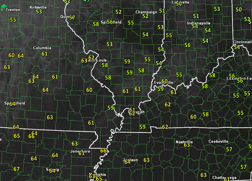
Tuesday delivered a lot of mild temperatures for our region. Mostly upper 50s to lower 60s. Here was the 3 pm temperature map for Tuesday.
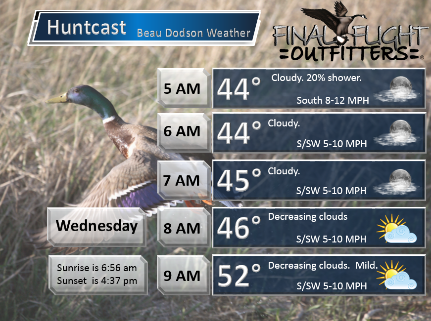
A weak system will push through our region Tuesday night and Wednesday morning. This will bring some clouds and perhaps a couple of light sprinkles or showers. Nothing major.
Clouds should decrease on Wednesday morning. The sun comes out and we should see some nice warming again. I have struggled with the cloud forecast this week. And, clouds keep temperatures down. I tried to lean myself towards the middle range of temperatures. But, temperatures on Monday reached into the 60s over much of the region (a few spots remained in the upper 50s).
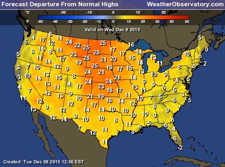
I increased the temperature forecast through Saturday by several degrees. Well above normal for December.
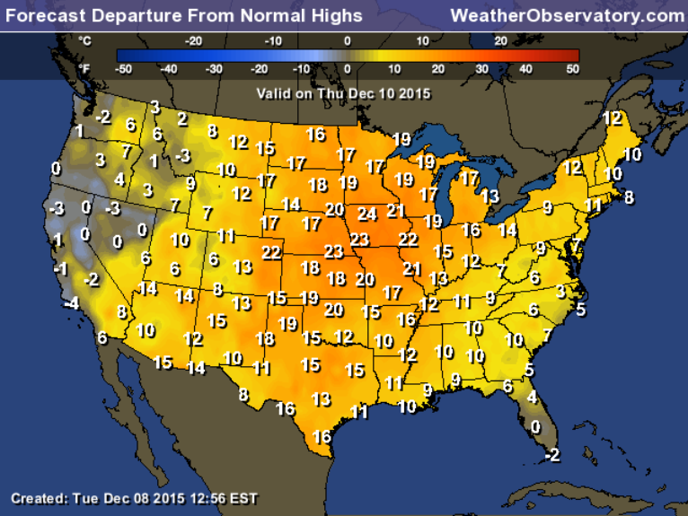
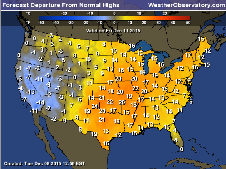
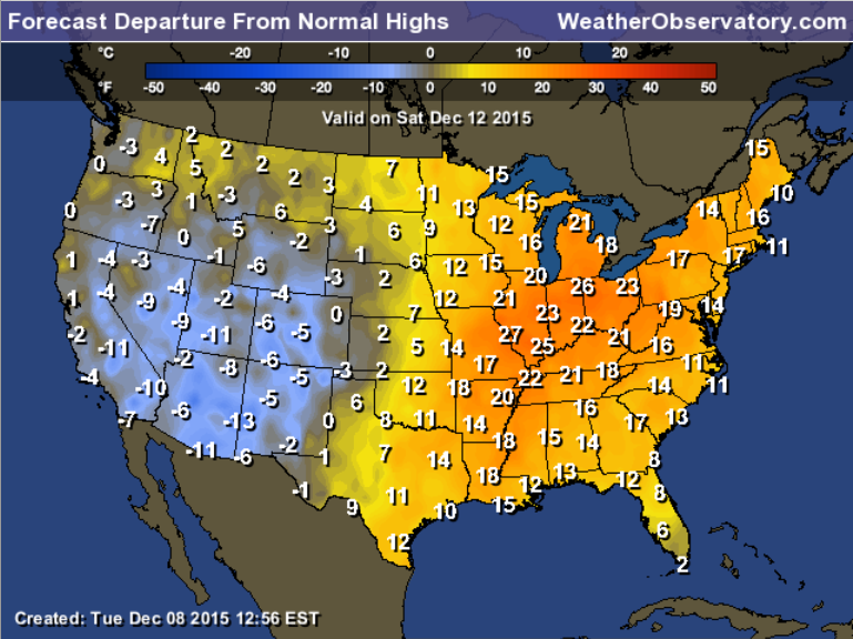
Speaking of temperatures. Here is the forecast temperature departure maps. How many degrees above or below normal will temperatures be over the coming days. Normal high temperatures are around 50 degrees.
Wednesday departures
Thursday depatures
Friday departures
Saturday departures
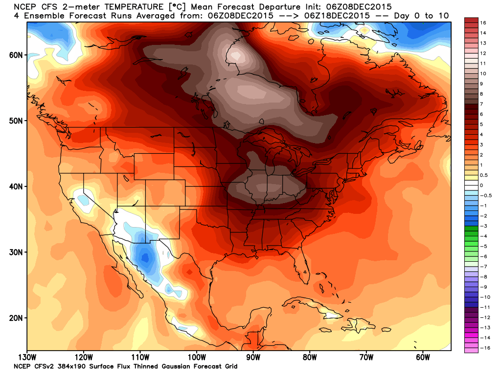
If you averaged out the temperatures from December 8th through the 18th this is what it should look like. A lot of above normal temperatures for the United States.
This image is from weatherbell.com Click image for a larger view.
Gusty winds could be an issue by Saturday and Saturday night. Those hunters waiting for a strong northwest wind might get their wish on Sunday night or Monday morning. Depending on when the cold front passes through the region. Once the front passes through then winds will turn out of the northwest. Could be some decent winds, as well.
Speaking of the cold front…
A strong storm system will push into our region this weekend. Ahead of the system we can expect winds to pick up from the south. When we have southerly winds we also have increasing dew points and moisture. Thus, a few showers can be ruled out Friday into Saturday. These should be on the light side on Friday/Friday night. Will need to monitor trends on the Saturday precipitation chances.
The main cold front and brunt of the showers and thunderstorms will arrive on Saturday night or Sunday. Model guidance is starting to move towards some agreement on timing. The GFS has been an outlier on pushing the system through on Saturday and Saturday evening. The general consensus is that the front will arrive on Sunday.
Widespread showers and thunderstorms will accompany the front. I am still monitoring the severe weather risk. The risk is not zero, but the risk does not appear great. Wind fields aloft will be quite strong on Saturday and Sunday. That is one ingredient for severe thunderstorms. However, CAPE values will be low. If you remember from previous discussions, CAPE is a measure of instability in the atmosphere. If CAPE values remain low then the severe weather risk will remain low.
As always, I will be monitoring and updating as we move forward.
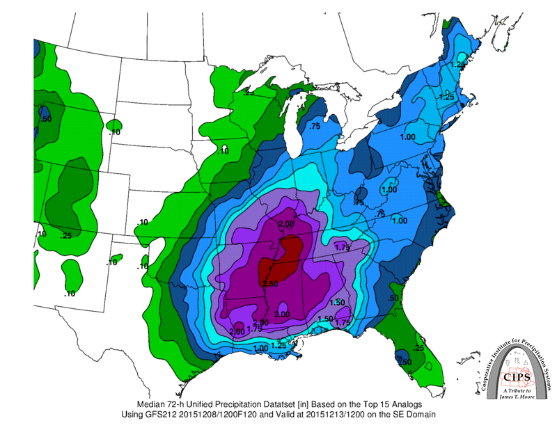
Let’s look at some CIPS Analogs. These maps represent past events. What happened when compared to the storm system this weekend.
The MEAN rainfall totals spike near our region. Perhaps one to two inches.
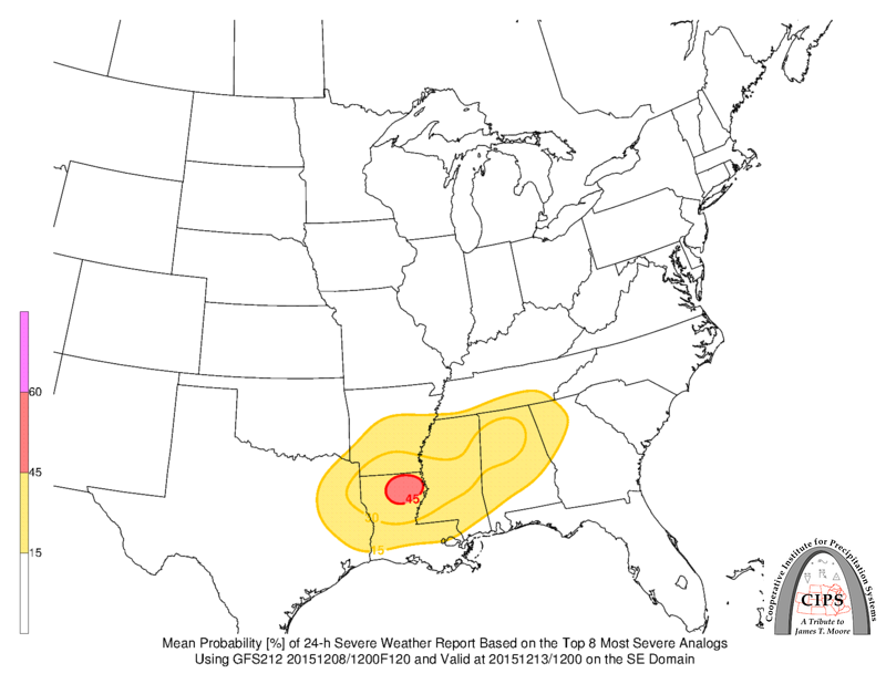
Looking at the severe potential. The GFS model guidance favors areas to our south for a few strong or severe storms.
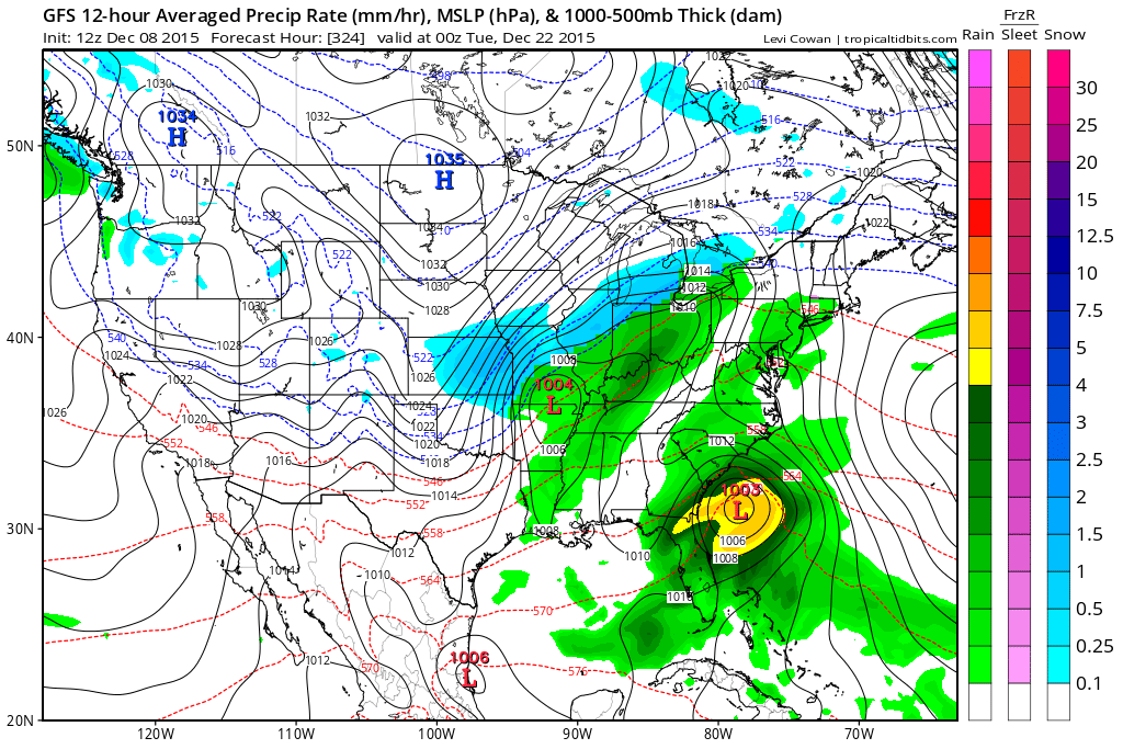
There are some indications of a strong push of cold air for the week of Christmas. Long way off. Confidence is low. Other data sets show a warm Christmas. Not sure if we see precipitation with the cold air. I suspect a snow event is possible somewhere in the Missouri and Ohio Valley. Whether that will be north of us is a question mark. Those with travel plans will need to monitor forecast updates for the week of Christmas. Perhaps the 21st through 24th.
Fairly active pattern setting up over the next two weeks.
Let’s look at a few maps
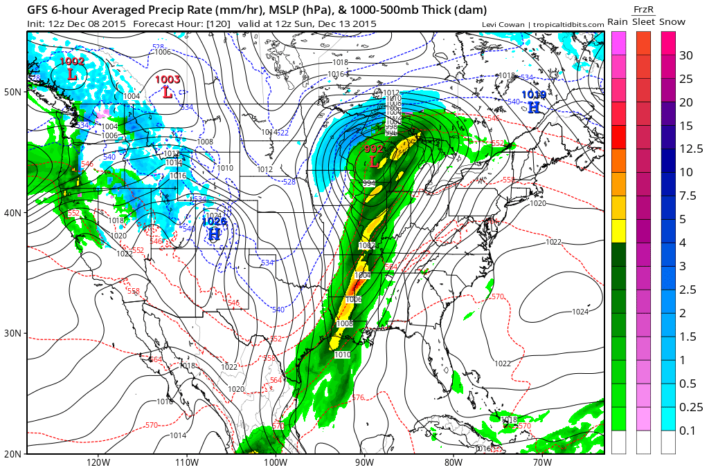
Here is the first storm system for the weekend. Green and yellow represents showers and maybe thunderstorms. Click image for a larger view. Timing of the front will need to be monitored. Leaning towards a Sunday passage for the front.
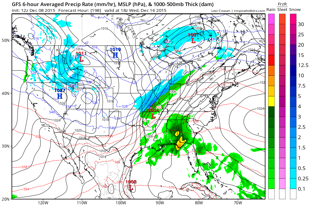
Here is another possible system around the 17th. That system could produce snow somewhere in the Missouri Valley. Long way off and low confidence. Something I will be monitoring.
Another system around the 22nd of December.
Bottom line: A fairly active pattern is developing and we will need to monitor the track of each of the low pressure centers. If the low goes to our south then we are on the cold side. If the low pressure goes to our north then we are on the warm side.
Click image for a larger view. Blue indicates snow. Green represents rain.

No snow anticipated.

Wednesday – No snow or ice anticipated.
Thursday – No snow or ice anticipated.
Friday – No snow or ice anticipated.
Saturday – No snow or ice anticipated.
Sunday – No snow or ice anticipated.
Monday – No snow or ice anticipated.

Increased temperatures. Changed wind speeds for Friday through Sunday. Still struggling with the timing of the cold front. If you have plans on Saturday or Sunday then monitor updates.

Watching thunderstorm chances for Saturday and Sunday. Perhaps some locally heavy rain and gusty winds. Monitor updates.

Not through Friday.

The wild card in this forecast will be the weekend storm system. The timing of the main rain shield is the main concern. Some of the model guidance brings the rain into the region on Saturday afternoon and evening. Other guidance holds it off until Sunday. I believe Saturday night into Sunday afternoon is the most likely scenario.

No significant frost or freeze in the current forecast.

How much precipitation should we expect over the next few days?
No rain expected through Thursday.
Maybe a few sprinkles or showers by Thursday night or Friday. Low confidence.
A stronger storm system is possible by the end of the new work week. That system could produce locally heavy rain on Saturday, Sunday/Monday. Let’s keep an eye on it.
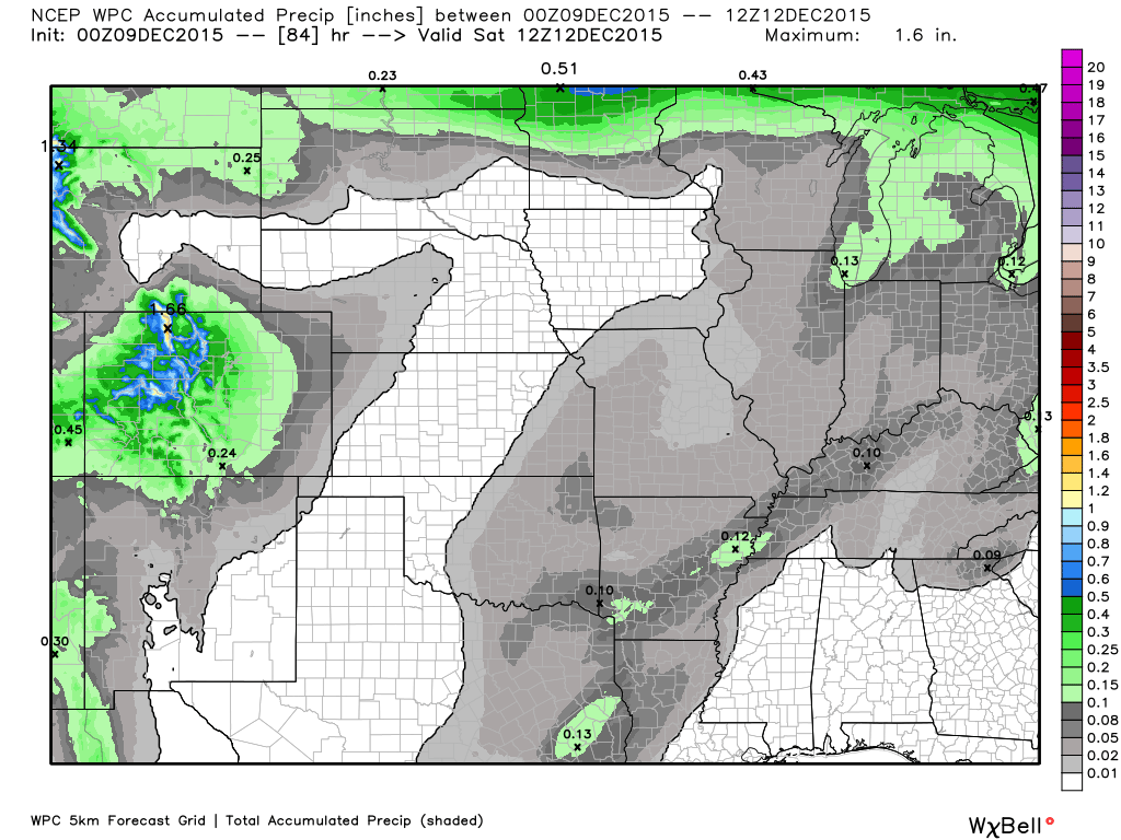
Here is the official rainfall forecast through Saturday morning.
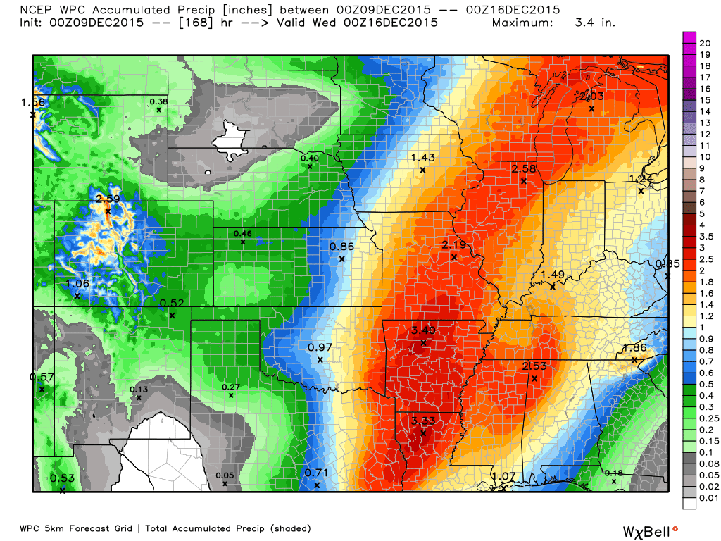
Here is the rainfall forecast through Monday. Click image for a larger view. Scale is on the right. Image is from weatherbell.com

Can we expect severe thunderstorms over the next 24 to 48 hours? Remember that a severe thunderstorm is defined as a thunderstorm that produces 58 mph winds or higher, quarter size hail or larger, and/or a tornado.
The thunderstorm threat level will be ZERO for Tuesday through Thursday
.
Wednesday: Severe weather is not anticipated.
Thursday: Severe weather is not anticipated.
Friday: Severe weather is not anticipated.
Saturday: Severe weather is not anticipated. Thunder possible.
Sunday: Monitor updates.
Monday: Monitor updates.
Tuesday: Severe weather is not anticipated.
Wednesday: Severe weather is not anticipated.

Here is the official 6-10 day and 8-14 day temperature and precipitation outlook. Check the date stamp at the top of each image (so you understand the time frame).
The forecast maps below are issued by the Weather Prediction Center (NOAA).


The latest 8-14 day temperature and precipitation outlook. Note the dates are at the top of the image. These maps DO NOT tell you how high or low temperatures or precipitation will be. They simply give you the probability as to whether temperatures or precipitation will be above or below normal.


Here are the current river stage forecasts. You can click your state and then the dot for your location. It will bring up the full forecast and hydrograph.
Click Here For River Stage Forecasts…

Who do you trust for your weather information and who holds them accountable?
I have studied weather in our region since the late 1970’s. I have 37 years of experience in observing our regions weather patterns. My degree is in Broadcast Meteorology from Mississippi State University and an Associate of Science (AS). I am currently working on my Bachelor’s Degree in Geoscience.
My resume includes:
Member of the American Meteorological Society.
NOAA Weather-Ready Nation Ambassador.
Meteorologist for McCracken County Emergency Management.
I own and operate the Southern Illinois Weather Observatory.
Recipient of the Mark Trail Award, WPSD Six Who Make A Difference Award, Kentucky Colonel, and the Caesar J. Fiamma” Award from the American Red Cross.
In 2009 I was presented with the Kentucky Office of Highway Safety Award.
Recognized by the Kentucky House of Representatives for my service to the State of Kentucky leading up to several winter storms and severe weather outbreaks.
I am also President of the Shadow Angel Foundation which serves portions of western Kentucky and southern Illinois.
There is a lot of noise on the internet. A lot of weather maps are posted without explanation. Over time you should learn who to trust for your weather information.
My forecast philosophy is simple and straight forward.
- Communicate in simple terms
- To be as accurate as possible within a reasonable time frame before an event
- Interact with you on Twitter, Facebook, and the blog
- Minimize the “hype” that you might see on television or through other weather sources
- Push you towards utilizing wall-to-wall LOCAL TV coverage during severe weather events
I am a recipient of the Mark Trail Award, WPSD Six Who Make A Difference Award, Kentucky Colonel, and the Caesar J. Fiamma” Award from the American Red Cross. In 2009 I was presented with the Kentucky Office of Highway Safety Award. I was recognized by the Kentucky House of Representatives for my service to the State of Kentucky leading up to several winter storms and severe weather outbreaks.
If you click on the image below you can read the Kentucky House of Representatives Resolution.

Many of my graphics are from www.weatherbell.com – a great resource for weather data, model data, and more


You can sign up for my AWARE email by clicking here I typically send out AWARE emails before severe weather, winter storms, or other active weather situations. I do not email watches or warnings. The emails are a basic “heads up” concerning incoming weather conditions.