
This forecast update covers far southern Illinois, far southeast Missouri, and far western Kentucky. See the coverage map on the right side of the blog.
Saturday – Cloudy. Any morning rain will exit off the east. Cool temperatures with highs from 40-45 degrees. North winds at 10-20 mph.
Saturday night – Cloudy and cool. Seasonable temperatures. Lows will be in the 32-36 degree range. North winds at 5-10 mph.
Sunday – Cloudy – perhaps some intervals of sun. Chilly. High temperatures from 38 to 44 degrees. Northeast winds at 5-10 mph.
Sunday night – Partly cloudy and chilly. Low temperatures in the 28 to 35 degree range. Northeast winds at 5 mph.
Monday – Partly sunny. Cool. Near normal to below normal temperatures. Highs will be in the 46 to 52 degree range. East winds at 5-10 mph.
Current Temperatures Around The Local Area


An explanation of what is happening in the atmosphere over the coming days.
Friday ended up being a wet wet wet day across the region. Rainfall totals varied. Most areas did pick up between 0.50″-1.00″. Some places had a bit more than that. A nice soaking fall rain.
Rain will move off to the east today. That will leave us with lots of clouds for today through Sunday. The good news is that it still be dry. The bad news is that temperatures will be well below normal (once again).
Short update today! The weather is calm and the next few days will bring calm, as well. I will be moving to a new apartment here in Chicago (I am in Chicago for awhile) on Sunday and Monday. Updates will likely be brief.
Let’s try a new way of looking at larger graphics – thumbnails. This is for Sunday and Monday high and low temperatures. Click on image for the full size
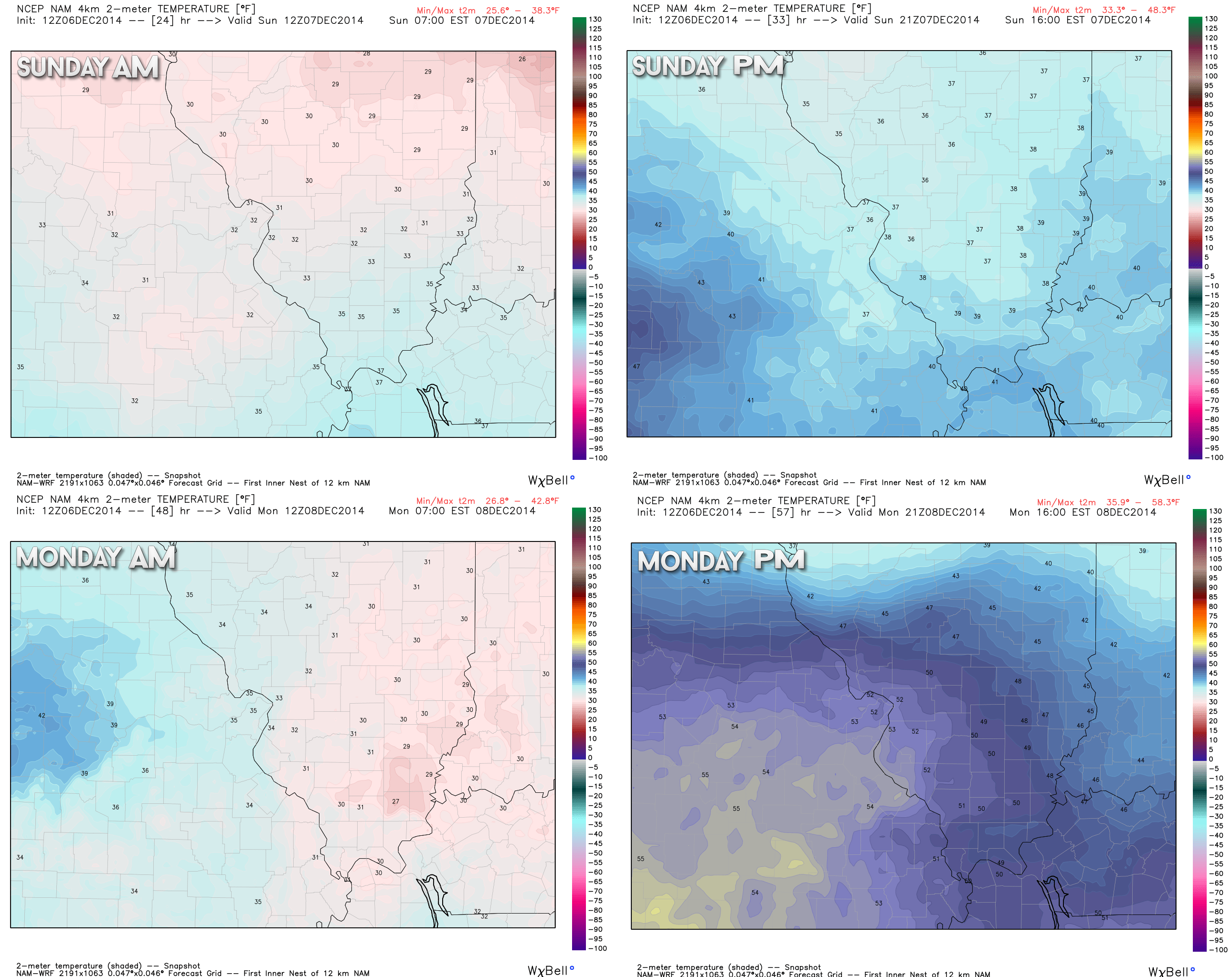

Adjusted temperatures down a bit for Sunday. Going to be a chilly day.

No major concerns!

The Wild Card gives you an idea of what might change that would cause the forecast to bust.
Wild card in this forecast – no wild cards in this calm forecast!

Can we expect severe thunderstorms over the next 24 to 48 hours? Remember that a severe thunderstorm is defined as a thunderstorm that produces 58 mph winds or higher, quarter size hail or larger, and/or a tornado.
Thunderstorm threat level is ZERO

Will I need to take action?
Jacket weather. That is about it.

Please visit your local National Weather Service Office by clicking here. The National Weather Service Office, for our region, is located in Paducah, Kentucky.

How much rain should this system produce over our region?
No rainfall thought Sunday night. Any rain leftover this morning should exit shortly.

We have regional radars and local city radars – if a radar does not seem to be updating then try another one. Occasional browsers need their cache cleared. You may also try restarting your browser. That usually fixes the problem. Occasionally we do have a radar go down. That is why I have duplicates. Thus, if one fails then try another one.
If you have any problems then please send me an email beaudodson@usawx.com
WEATHER RADAR PAGE – Click here —
We also have a new national interactive radar – you can view that radar by clicking here.
Local interactive city radars include St Louis, Mt Vernon, Evansville, Poplar Bluff, Cape Girardeau, Marion, Paducah, Hopkinsville, Memphis, Nashville, Dyersburg, and all of eastern Kentucky – these are interactive radars. Local city radars – click here
NOTE: Occasionally you will see ground clutter on the radar (these are false echoes). Normally they show up close to the radar sites – including Paducah.

Regional Radar – Click on radar to take you our full radar page.


Regional Radar

Sorry kids! Still no snow in the forecast.

Next week should bring below normal temperatures. At least early on into the middle of the week. The next question mark will be the Friday through Sunday time period. It does appear a storm system may move out of the Midwest. If this storm tracks well to our northwest then that would bring milder air northward.
A fairly boring weather pattern this weekend into the middle of next week. Perhaps a bit more active as we push into the late week time period.

You can sign up for my AWARE email by clicking here I typically send out AWARE emails before severe weather, winter storms, or other active weather situations. I do not email watches or warnings. The emails are a basic “heads up” concerning incoming weather conditions.
Many of my graphics are from www.weatherbell.com – a great resource for weather data, model data, and more


This blog was inspired by ABC 33/40’s Alabama Weather Blog – view their blog
Current tower cam view from the Weather Observatory- Click here for all cameras.

Southern Illinois Weather Observatory

The Weather Observatory

Southern Illinois Weather Observatory
WSIL TV 3 has a number of tower cameras. Click here for their tower camera page & Illinois Road Conditions

Marion, Illinois
WPSD TV 6 has a number of tower cameras. Click here for their tower camera page & Kentucky Road Conditions & Kentucky Highway and Interstate Cameras

Downtown Paducah, Kentucky
Benton, Kentucky Tower Camera – Click here for full view

Benton, Kentucky

I24 Paducah, Kentucky

I24 Mile Point 9 – Paducah, KY

I24 – Mile Point 3 Paducah, Kentucky