12 PM Update
Showers and thunderstorms will push through the region this afternoon and evening. A few of the thunderstorms could produce gusty winds. The severe weather threat is minimal.
Heavy downpours are a good bet from time to time.
Precipitation should come to an end late tonight.
Dry weekend expected. Cooler temperatures.

This forecast update covers far southern Illinois, far southeast Missouri, and far western Kentucky. See the coverage map on the right side of the blog.
If you find value in this page and the other weather products on the Weather Observatory web-site then consider making a donation to keep everything up and running. It does cost quite a bit of money each month to run the radars, data feeds, hosting of sites, and more. You can give by visiting our donation page.
Friday – Fog this morning. Showers and thunderstorms off and on today. There will be some lulls in the precipitation. Much above normal temperatures. Temperatures will rise into the 60’s over parts of southeast Missouri, far southern Illinois and western Kentucky. Northern parts of the area may remain in the upper 40’s and lower 50’s. South winds at 5-10 mph.
Morning School Bus Stop Weather – Fog. Some showers around. Temperatures during the morning will be around 45 degrees.
Afternoon School Bus Stop Weather – Cloudy with some showers and possibly a thunderstorm. Temperatures will be in the upper 50’s.
Friday night – Cloudy with showers and thunderstorms. Locally heavy rain possible. A few storms could produce gusty winds. Low temperatures will be in the 40’s. Southwest winds at 10-20 mph becoming northwest at 10-15 mph.
Saturday – Cloudy with rain ending. Temperatures falling through the day. Highs will be early in the day. Temperatures will fall into the lower 40’s by late afternoon. North winds at 10-20 mph.
Saturday night – Mostly cloudy and cool. Low temperatures in the lower 30’s. Northeast winds at 5-10 mph.
Sunday – Partly cloudy and cool. High temperatures only in the lower 40’s. Northeast winds at 5-10 mph.
Current Temperatures Around The Local Area


An explanation of what is happening in the atmosphere over the coming days.
Well, fog rolled into the region yesterday evening and has stuck around this morning. I am guessing most of you had to deal with the fog as you were out and about (or getting ready to leave this morning). Use care.
Fog will dissipate as we move through the morning hours.
A warm front will push north today. That warm front will signify a change in how the atmosphere feels. Dew points will be on the rise (more moisture in the air) and temperatures will be on the rise. Expect temperatures to push above 60 degrees later today!
Showers and thunderstorms are expected today into tonight. There will be lulls in the precipitation from time to time.
As an area of low pressure pushes moves into the region we will see instability increase a bit. This low will push off to our north. When a low moves out of Missouri and into Illinois (to our north) that usually places are region in the warm sector of the system. That means thunderstorms will be possible. There is a small risk that a few storms will become severe. The main concern would be high winds.
A cold front will move through the area late tonight into Saturday morning. Cooler air will filter in behind the cold front. Showers and thunderstorms will come to an end on Saturday morning. Clouds, however, will linger through much of Saturday and even Saturday night.
Sunday will bring partly cloudy sky conditions and below normal temperatures. Highs won’t get out of the 40’s on Sunday. Chilly.

No major changes to the forecast this morning. I added the mention of dense fog in last nights update. Lot of fog over the region.
I also added the mention that a few thunderstorms could approach severe levels later this afternoon and tonight. Yesterday it appeared there was not a risk for severe weather. Latest data indicates that perhaps there is at least a small risk for one or two storms to produce high winds.

Some thunderstorms today and tonight will produce locally heavy rain and gusty winds. There is a chance that a storm or two could become severe. The overall severe weather risk is minimal, but not zero. Wind fields aloft and some surface based instability might be enough to produce a few heavier storms.

The Wild Card gives you an idea of what might change that would cause the forecast to bust.
Wild card in this forecast – whether or not a few thunderstorms will approach or become severe. The overall risk appears small. Not zero, but small. That is the wild card for today.

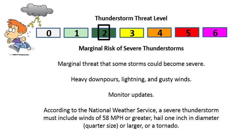
Can we expect severe thunderstorms over the next 24 to 48 hours? Remember that a severe thunderstorm is defined as a thunderstorm that produces 58 mph winds or higher, quarter size hail or larger, and/or a tornado.
Thunderstorm threat level is MARGINAL.
A few thunderstorms could approach severe levels later today and tonight. The overall severe weather risk appears minimal. Instability should increase later this afternoon and tonight. Wind fields are strong but not overly impressive for this time of the year. Dew points will be high enough to at least consider the risk for a few heavier thunderstorm cells.
If a line of storms develops later this afternoon or tonight then any bow segments in the line could produce strong winds.

Live Lightning Data – zoom and pan: Click here
Live Lightning Data with sound (click the sound button on the left side of the page): Click here
Day 1 Severe Weather Outlook from the Storm Prediction Center – Storm Prediction Center
What does thunderstorms, marginal, slight, enhanced, medium, and high risk mean? Click here


Will I need to take action?
Umbrellas will be in order into tonight. Some locally heavy rain.
Otherwise, monitor updates in case a few storms approach severe levels later today and this evening. Storm tracking links below.

Please visit your local National Weather Service Office by clicking here. The National Weather Service Office, for our region, is located in Paducah, Kentucky.

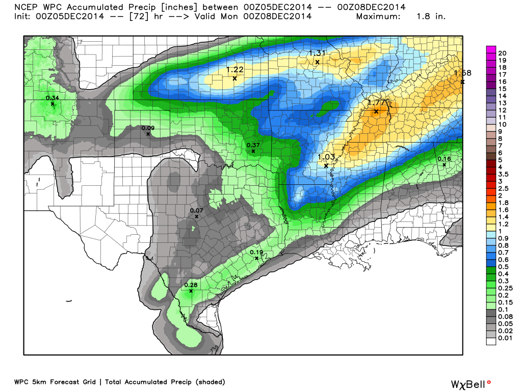
How much rain should this system produce over our region?
Widespread rainfall totals of 0.80″-1.50″. Can’t rule out a few spots picking up heavier amounts. Quite a bit of rain today into tonight.

We have regional radars and local city radars – if a radar does not seem to be updating then try another one. Occasional browsers need their cache cleared. You may also try restarting your browser. That usually fixes the problem. Occasionally we do have a radar go down. That is why I have duplicates. Thus, if one fails then try another one.
If you have any problems then please send me an email beaudodson@usawx.com
WEATHER RADAR PAGE – Click here —
We also have a new national interactive radar – you can view that radar by clicking here.
Local interactive city radars include St Louis, Mt Vernon, Evansville, Poplar Bluff, Cape Girardeau, Marion, Paducah, Hopkinsville, Memphis, Nashville, Dyersburg, and all of eastern Kentucky – these are interactive radars. Local city radars – click here
NOTE: Occasionally you will see ground clutter on the radar (these are false echoes). Normally they show up close to the radar sites – including Paducah.

Regional Radar – Click on radar to take you our full radar page.


Regional Radar

Current WARNINGS (a warning means take action now). Click on your county to drill down to the latest warning information. Keep in mind that there can be a 2-3 minute delay in the updated warning information.
I strongly encourage you to use a NOAA Weather Radio or warning cell phone app for the most up to date warning information. Nothing is faster than a NOAA weather radio.


Missouri Warnings

Illinois Warnings

Kentucky Warnings

Sorry kids! No snow in the forecast over the coming days. I keep watching. I keep coming up empty handed.

Well, I keep wondering how next week will unfold. Lot of the data is showing above normal temperatures. Whether or not a cut off low develops over the Ohio Valley is going to play a big factor in whether or not we end up with milder weather or cooler weather. Whether a big storm system develops and pushes up the East Coast will also be a big factor in whether cooler air will filter into our region.
Hard to ignore all of the data showing the above normal temperatures next week. I was holding out that perhaps the trough would develop and thus bring cooler than normal weather. Let’s see how the data unfolds today and tomorrow. Still some time to go.
There were some thoughts that perhaps November would be cold and then December would end up slightly above normal in the temperature department. Then January and February would be bitterly cold. I guess it will be interesting to see if that actually happens. I was in the cold camp for November and then thought perhaps we would see some moderation in temperatures for part of December. Then I thought we would head into the deep freeze as we pushed towards January and into February. We shall see how it actually goes.
Obviously November was COLD. Well below normal temperatures were the rule.
Either way, I don’t see a winter storm threat next week. So, for those of you wanting snow – you may have to wait a bit longer. Sorry snow fans.
We may have to deal with another round of precipitation late next week.

You can sign up for my AWARE email by clicking here I typically send out AWARE emails before severe weather, winter storms, or other active weather situations. I do not email watches or warnings. The emails are a basic “heads up” concerning incoming weather conditions.
Many of my graphics are from www.weatherbell.com – a great resource for weather data, model data, and more


This blog was inspired by ABC 33/40’s Alabama Weather Blog – view their blog
Current tower cam view from the Weather Observatory- Click here for all cameras.

Southern Illinois Weather Observatory

The Weather Observatory

Southern Illinois Weather Observatory
WSIL TV 3 has a number of tower cameras. Click here for their tower camera page & Illinois Road Conditions

Marion, Illinois
WPSD TV 6 has a number of tower cameras. Click here for their tower camera page & Kentucky Road Conditions & Kentucky Highway and Interstate Cameras

Downtown Paducah, Kentucky
Benton, Kentucky Tower Camera – Click here for full view

Benton, Kentucky

I24 Paducah, Kentucky

I24 Mile Point 9 – Paducah, KY

I24 – Mile Point 3 Paducah, Kentucky