8 PM Update…
Dense fog tonight – use care.

This forecast update covers far southern Illinois, far southeast Missouri, and far western Kentucky. See the coverage map on the right side of the blog.
Thursday – Cloudy. Some scattered showers. High temperatures in the 40’s. Northeast/east winds of 5 mph.
Morning School Bus Stop Weather – Cloudy. A chance for a shower. East winds of 5-10 mph. Temperatures in the upper 30’s and lower 40’s.
Afternoon School Bus Stop Weather – Cloudy. A chance for a shower. East winds of 5-10 mph. Temperatures in the middle 40’s.
Thursday night – Cloudy. A few showers possible. Low temperatures holding steady in the 40’s. Southeast winds of 10 mph.
Friday – Cloudy. On and off periods of showers and even thunderstorms. Some locally heavy downpours possible. High temperatures in the 40’s over our northern counties and rising through the 50’s for our southern counties. Temperatures over far southern Illinois and western Kentucky may rise above 60 degrees! South winds of 10-15 mph.
Friday night – Cloudy. Rain. Perhaps a rumble of thunder. Some heavy downpours possible. Low temperatures in the upper 40’s. South winds of 10-20 mph. Winds turning out of the northwest late.
Saturday – Cloudy. Rain coming to an end from west to east during the early morning hours. High temperatures in the upper 40’s. Northwest winds of 10-20 mph
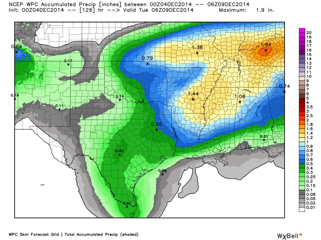
Rainfall Totals: Widespread rainfall totals of 0.80″-1.50″. Some pockets of heavier totals likely.
Current Temperatures Around The Local Area


An explanation of what is happening in the atmosphere over the coming days.
An unsettled pattern of weather is upon us. Clouds and rain will be the rule over the coming days. The good news is that the rain comes to an end by Saturday. Not that a lot of people have outdoor plans in December, but at least the weekend won’t be a complete wash out.
Precipitation chances will be scattered this morning into the afternoon hours. Perhaps the best chances of rain shifting north and east with time. That means we will have dry spells today. Today is not the “widespread” rain event.
Widespread rain develops later tonight and will continue into Friday night. Expect 70%-90% chances for rain over the area.
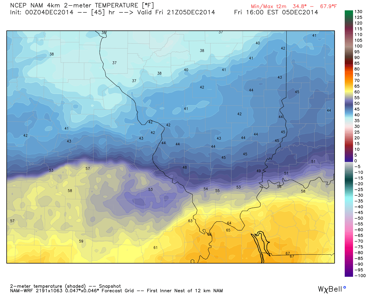
Temperatures are going to vary across the region over the coming days. A warm front passes into western Kentucky and far southern Illinois on Friday. Temperatures south of the warm front will be in the lower 60’s. Temperatures over our northern counties may remain in the 40’s for much of the day. Fairly sharp contrast in temperatures.
Thunderstorms are not out of the question as the stronger dynamics move over our region on Friday. I have added a marginal risk for a few thunderstorms to become severe on Friday/Friday night.
Showers and thunderstorms come to an end by early Saturday morning. That will leave us with a dry Saturday and Sunday. Clouds may be difficult to move out on Saturday. Temperatures will also be colder behind the cold front – nothing dramatic.
Speaking of temperature swings – let’s take a look at that warm front on Friday. This is the temperature forecast for Friday around 3 pm. See those warmer temps over western Kentucky and far southern Illinois? Compare those to our northern counties. That warm air will quickly sweep into our region. Don’t get used to it.
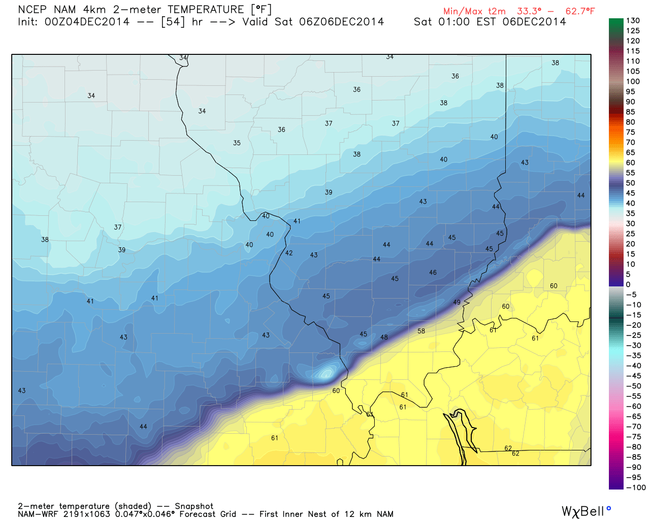
Now here are the temperatures for Friday night around 11 pm through 1 am on Saturday morning. You can see the cooler air moving in from the northwest. The warm air still covers the southeast half of our region. Don’t you just love the temperature contrasts during the winter months?
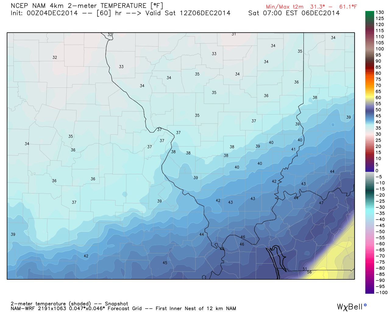
And finally – here are the temperatures on Saturday around 7 am.

I changed the high and low temperatures forecasts a bit. Highs at or above 60 appear likely on Friday. This occurs as a warm front pushes through parts of the region. Northern counties may not get out of the 40’s. Keep that in mind – quite the spread of temperatures over southern Illinois.
I increased rainfall totals a little bit. Most areas should see a decent soaking rain.
I have increased wording on the thunderstorm concerns.

A few heavy downpours on Friday and Friday night. The latest data indicates a small risk for a few thunderstorms to approach severe levels. This will need to be monitored.

The Wild Card gives you an idea of what might change that would cause the forecast to bust. A busted forecast means a forecast that does not verify. For example, if a winter storm (the area of low pressure) shifts its track 50 miles further south than expected, then that could cause a dramatic change in how much snow might or might not accumulate.
Wild card in this forecast – the wild card in this forecast will be rainfall totals from location to location. I think most areas will pick up 0.80″-1.50″. We will see if some places can go over those amounts.

Can we expect severe thunderstorms over the next 24 to 48 hours? Remember that a severe thunderstorm is defined as a thunderstorm that produces 58 mph winds or higher, quarter size hail or larger, and/or a tornado.
Thunderstorm threat level is at level 2 – A few storms could approach severe levels. Locally heavy rain, lightning, and perhaps gusty winds. Small tornado risk.


Live Lightning Data – zoom and pan: Click here
Live Lightning Data with sound (click the sound button on the left side of the page): Click here

Will I need to take action?
Umbrellas over the coming days will be in high demand! Otherwise, no action required.

Please visit your local National Weather Service Office by clicking here. The National Weather Service Office, for our region, is located in Paducah, Kentucky.

How much rain should this system produce over our region?
Widespread rain event setting up for our region. The highest chances for rain will arrive later tonight into Friday. Scattered chances today.
Rainfall totals should be in the 0.80″-1.50″ range. Here is the latest graphic. You can see pockets of heavier totals (at least possible)
Scale is on the right side of the image.


We have regional radars and local city radars – if a radar does not seem to be updating then try another one. Occasional browsers need their cache cleared. You may also try restarting your browser. That usually fixes the problem. Occasionally we do have a radar go down. That is why I have duplicates. Thus, if one fails then try another one.
If you have any problems then please send me an email beaudodson@usawx.com
WEATHER RADAR PAGE – Click here —
We also have a new national interactive radar – you can view that radar by clicking here.
Local interactive city radars include St Louis, Mt Vernon, Evansville, Poplar Bluff, Cape Girardeau, Marion, Paducah, Hopkinsville, Memphis, Nashville, Dyersburg, and all of eastern Kentucky – these are interactive radars. Local city radars – click here
NOTE: Occasionally you will see ground clutter on the radar (these are false echoes). Normally they show up close to the radar sites – including Paducah.

Regional Radar – Click on radar to take you our full radar page.


Regional Radar

Sorry kids (and fellow snow lovers) – I am not tracking any winter storms. Keep checking back.

Short update…
Next week is shaping up to be cooler than normal. I am not sure we can get much precipitation out of next weeks pattern. A closed off low may develop somewhere in the Ohio Valley. This would mean colder temperatures, but perhaps the best rain or snow chances off to our east.
I will, of course, monitor for changes. Quite a bit of variability in the model data for next week. I don’t trust any particular model at this point.
A typhoon in the Pacific may once again make big news in America. Our weather may be impacted by that typhoon. Another blast of cold air? Perhaps.
Many of my graphics are from www.weatherbell.com – a great resource for weather data, model data, and more


This blog was inspired by ABC 33/40’s Alabama Weather Blog – view their blog
Current tower cam view from the Weather Observatory- Click here for all cameras.

Southern Illinois Weather Observatory

The Weather Observatory

Southern Illinois Weather Observatory
WSIL TV 3 has a number of tower cameras. Click here for their tower camera page & Illinois Road Conditions

Marion, Illinois
WPSD TV 6 has a number of tower cameras. Click here for their tower camera page & Kentucky Road Conditions & Kentucky Highway and Interstate Cameras

Downtown Paducah, Kentucky
Benton, Kentucky Tower Camera – Click here for full view

Benton, Kentucky

I24 Paducah, Kentucky

I24 Mile Point 9 – Paducah, KY

I24 – Mile Point 3 Paducah, Kentucky

You can sign up for my AWARE email by clicking here I typically send out AWARE emails before severe weather, winter storms, or other active weather situations. I do not email watches or warnings. The emails are a basic “heads up” concerning incoming weather conditions.