
This forecast update covers far southern Illinois, far southeast Missouri, and far western Kentucky. See the coverage map on the right side of the blog.
A complicated weather pattern is developing over the next 7-10 days. Check back for updates as we move forward. The upper level pattern is favorable for several chances of rain. Temperatures will be a little tricky to forecast from time to time because of cloud cover.
Wednesday – Mostly cloudy. Cool. High temperatures in the 40’s. Northwest 5 mph.
Morning School Bus Stop Weather – Mostly cloudy and cool. Temperature at the bus stop will be around 30 degrees.
Afternoon School Bus Stop Weather – Cloudy. Temperatures at the bus stop will be around 42 degrees.
Wednesday night -Cloudy. A chance for a few showers late at night. A chance for a short period of sleet or freezing rain, as well. Low temperatures will be in the lower to middle 30’s. Northeast winds at 5-10 mph. Chance of rain 20% by midnight and 30%-40% during the wee hours of the morning.
Thursday – Clouds. Scattered showers. Showers early on may have sleet mixed in. Small chance for a brief period of freezing rain. Cool. High temperatures will be in the 30’s over much of southern Illinois and 40’s over far southern Illinois and western Kentucky. South winds at 10 mph. Chance of rain will be 40%-60%.
Thursday night – Increasing chances for showers. Cool. Low temperatures will be in the 30’s. South winds at 5-10 mph. Chance of rain increasing to 70%.
Friday – Rain likely. Periods of moderate rain possible. Cool temperatures. Highs will be in the 40’s over southern Illinois and lower 50’s over western Kentucky. South/Southeast winds at 5-10 mph. Rain chances will be 80%
Friday night – Rain. Temperatures will be in the upper 40’s over southern Illinois and lower 50’s over western Kentucky. East/northeast winds at 5-10 mph. Rain chances will be 80%
Saturday – Cloudy with a few morning showers. Rain exiting off the east. Below normal temperatures. North winds at 10 mph. Highs in the upper 40’s and lower 50’s.

An explanation of what is happening in the atmosphere over the coming days.
Short update today because I was in class till 9 pm last night.
Highlights:
1. Rain chances (perhaps brief period of sleet mixed in – freezing rain mixed in) increase tonight into Thursday night. There will be a dramatic increase in coverage of the precipitation on Thursday night into Friday. There could be some moderate rain at times. Right now the chance for thunderstorms appear fairly low. A rumble of thunder, however, can’t be ruled out.
2. Below normal temperatures over the coming days. Some moderation in temperatures as a warm front approaches our region on Friday. Temperatures at night might be a few degrees above normal. Daytime highs, however, will be below normal.
Normal high temperatures for this time of the year are around 52 degrees. Normal low temperatures for this time of the year are around 32 degrees.
You can see on the world view that our region is still painted in a bit of blue. The core of the blue is up in Canada. That represents below normal temperatures. Remember what it looked like back in November? We were in the core of the coldest air.
Today’s world view – blue is below normal temps and the reddish colors represent above normal temperatures.
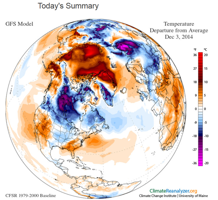
Models have been next to useless lately when it comes to sensible weather. They have been way too warm. Lot of them showed warm weather for this week. That has not happened. A lot of them have shown warm weather next week. I am skeptical about that happening. We shall see.
The short term forecast will be dominated by a cold front dropping south into our region and then a warm front developing to our southwest. Several upper level disturbances will push across our region over the coming 48-72 hour period.
Expect rain to develop in response to this warmer air flowing into our region. This will also keep clouds around.
There is a lower than normal confidence on high and low temperatures over the next 3-4 days. A lot of cloud cover and occasional precipitation will help keep temperatures down. The good news is that outside of tonight all of the precipitation should be in the form of rain.
There is a brief window of time tonight and early Thursday morning where sleet and perhaps even freezing rain will mix in with the rain. This will be dependent on surface temperatures over the region. Best chance of temperatures being cold enough for a brief period of freezing rain would be the Missouri Ozarks and then over towards southwest Illinois – perhaps Randolph, Perry, and Jackson Counties. That area. Areas outside of there could briefly go below freezing, as well. See the temp forecast map below.
Here is the temperature map for late tonight – the freezing line does briefly push down into much of southern Illinois. It will rebound tomorrow morning.
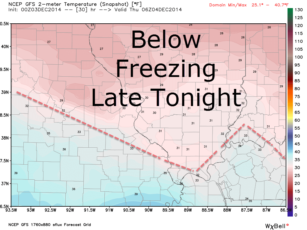
Temperatures will rise on Thursday and shut down the potential for frozen precipitation. Remember that it only takes a hint of freezing rain or drizzle to cause problems. Monitor updates. I will update the blog late this afternoon or evening.
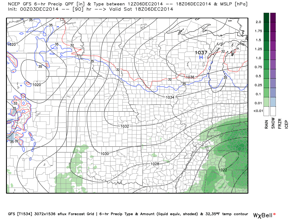
Here is what the GFS model is showing for Friday and around 12 pm on Saturday. Lot of green on that map (rain). You can see on the second map that the precipitation is on the way out by Saturday morning.
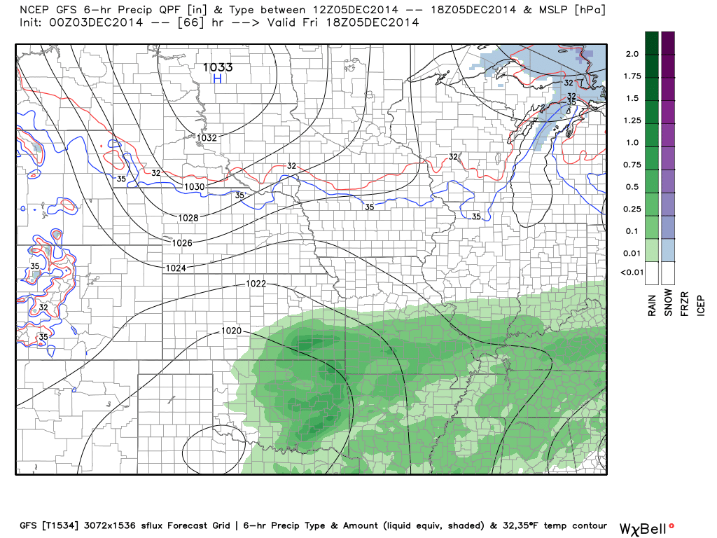
Saturday at 12 PM

I did add the mention of light rain showers Wednesday night/Thursday morning. Also included the mention of a brief period of sleet or freezing rain.

If any frozen precipitation does develop tonight then there is a brief window of opportunity for a few slick spots – esp true over parts of southeast MO into southwest IL. Remember that it only takes a hint of freezing rain or drizzle to cause problems. Monitor updates.

The Wild Card gives you an idea of what might change that would cause the forecast to bust. A busted forecast means a forecast that does not verify. For example, if a winter storm (the area of low pressure) shifts its track 50 miles further south than expected, then that could cause a dramatic change in how much snow might or might not accumulate.
Wild card in this forecast – Whether or not there will be a brief window of opportunity for light freezing rain or sleet over parts of the Missouri Ozarks and perhaps even into parts of southwest/south Illinois. The time frame would be very late tonight into the wee hours of Thursday morning.
Remember that it only takes a hint of freezing rain or drizzle to cause problems. Monitor updates.

Can we expect severe thunderstorms over the next 24 to 48 hours? Remember that a severe thunderstorm is defined as a thunderstorm that produces 58 mph winds or higher, quarter size hail or larger, and/or a tornado.
Thunderstorm threat level is ZERO


Will I need to take action?
Umbrella weather over the coming days. Scattered showers late tonight and Thursday. Widespread rain late Thursday night into Friday night.

Please visit your local National Weather Service Office by clicking here. The National Weather Service Office, for our region, is located in Paducah, Kentucky.

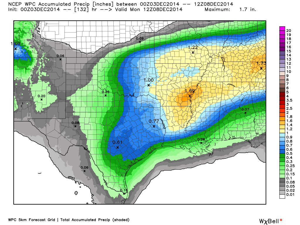
How much rain should this system produce over our region?
Here is the latest official rainfall forecast through Monday. Appears we should have a period or two of light to moderate rainfall.
Scale is on the right side of the page

A small chance for a brief period of freezing rain or sleet on Wednesday night. Remember that it only takes a hint of freezing rain or drizzle to cause problems. Monitor updates.
I am not tracking any significant winter storms for our area. I will be watching for the develop of an upper level low next week. Could mean colder than normal weather. We will have to see if any precipitation develops, as well. Too far off for details.
We have regional radars and local city radars – if a radar does not seem to be updating then try another one. Occasional browsers need their cache cleared. You may also try restarting your browser. That usually fixes the problem. Occasionally we do have a radar go down. That is why I have duplicates. Thus, if one fails then try another one.
If you have any problems then please send me an email beaudodson@usawx.com
WEATHER RADAR PAGE – Click here —
We also have a new national interactive radar – you can view that radar by clicking here.
Local interactive city radars include St Louis, Mt Vernon, Evansville, Poplar Bluff, Cape Girardeau, Marion, Paducah, Hopkinsville, Memphis, Nashville, Dyersburg, and all of eastern Kentucky – these are interactive radars. Local city radars – click here
NOTE: Occasionally you will see ground clutter on the radar (these are false echoes). Normally they show up close to the radar sites – including Paducah.

Regional Radar – Click on radar to take you our full radar page.


Regional Radar

Current WARNINGS (a warning means take action now). Click on your county to drill down to the latest warning information. Keep in mind that there can be a 2-3 minute delay in the updated warning information.
I strongly encourage you to use a NOAA Weather Radio or warning cell phone app for the most up to date warning information. Nothing is faster than a NOAA weather radio.


Many of my graphics are from www.weatherbell.com – a great resource for weather data, model data, and more


This blog was inspired by ABC 33/40’s Alabama Weather Blog – view their blog
Current tower cam view from the Weather Observatory- Click here for all cameras.

Southern Illinois Weather Observatory

The Weather Observatory

Southern Illinois Weather Observatory
WSIL TV 3 has a number of tower cameras. Click here for their tower camera page & Illinois Road Conditions

Marion, Illinois
WPSD TV 6 has a number of tower cameras. Click here for their tower camera page & Kentucky Road Conditions & Kentucky Highway and Interstate Cameras

Downtown Paducah, Kentucky
Benton, Kentucky Tower Camera – Click here for full view

Benton, Kentucky

I24 Paducah, Kentucky

I24 Mile Point 9 – Paducah, KY

I24 – Mile Point 3 Paducah, Kentucky