We have our first sponsor for the blog. Milner and Orr Funeral Home and Cremation Services located in Paducah, Kentucky and three other western Kentucky towns – at Milner and Orr they believe in families helping families.
![]()

This forecast update covers far southern Illinois, far southeast Missouri, and far western Kentucky. See the coverage map on the right side of the blog.
Monday – A mix of sun and clouds. It will be cooler with high temperatures in the upper 30’s and lower 40’s. Northeast winds at 5-10 mph.
Monday night – Partly cloudy with a flurry possible. Lows will be in the 20’s. Northeast winds at 5-10 mph.
Tuesday – A mix of sun and clouds. Small chance for a snow flurry. A little bit colder with high temperatures only in the 30’s. North/northeast winds at 5-10 mph.
Tuesday night – Just a few clouds. It will be chilly with overnight lows in the upper teens and lower 20’s. North/northeast winds at 5-10 mph.
Wednesday – Partly cloudy and chilly. High temperatures only in the upper 20’s and lower 30’s. North/northwest winds at 5-10 mph.

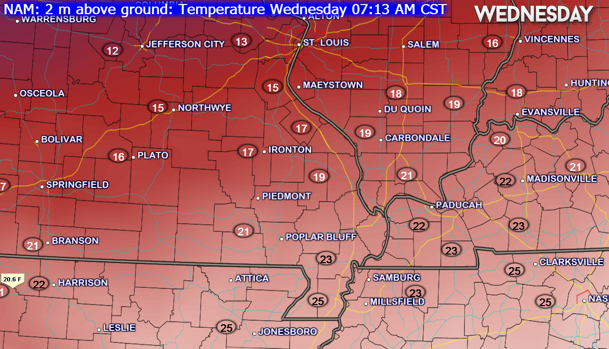
Current Temperatures Around The Local Area


An explanation of what is happening in the atmosphere over the coming days.
A calm few days of weather ahead of us. It will be colder, but nothing extreme for this time of the year. No block buster cold air in the forecast through next weekend (at least for our immediate local area). A bit of a snoozer for weather folk. Calm is good for all of you who have to travel.
It will at least feel more like winter than recent weeks.
Wednesday morning will bring some teens to the region (remember it is almost January)
A secondary cold front will bring a reinforcing shot of cold air on Monday night and Tuesday – I can’t completely rule out some snow flurries with the front. Lot of dry air aloft – so the chances seem pretty low. Perhaps our northwest counties.
New Years Eve and New Years Day should bring dry but chilly conditions. I do not see any travel problems on either day.
The next precipitation maker arrives late this week. See the extended forecast for the latest details on that event. This system is anything but set in stone.

No major changes to the ongoing forecast. I did mention snow flurries for Monday night as a second cold front moves into our area.

I have no major concerns through Thursday morning.
 The wild card tells you where the most uncertainty is in the current forecast.
Wild card in this forecast – No wild card in this forecast. A calm few days ahead of us.

I have no severe weather concerns through Thursday morning!
Can we expect severe thunderstorms over the next 24 to 48 hours? Remember that a severe thunderstorm is defined as a thunderstorm that produces 58 mph winds or higher, quarter size hail or larger, and/or a tornado.
Thunderstorm threat level is ZERO


Will I need to take action?
No action required

How much rain should this system produce over our region?
A calm few days ahead of us. No rain or snow.

Do I even have to tell? No snow in the forecast through Thursday morning. Sorry snow lovers.
I did mention flurries fro Monday night and early Tuesday morning. This should not amount to much and many people might sleep through it (if flurries develop at all)
I am watching a system for Thursday night into Saturday night. If the precipitation moves in fast enough then it could begin as a light wintry mix before changing over to all rain on Friday and Saturday. As the system pulls away there might be a chance for the rain to turn back over to snow.
Some of the data holds off precipitation until later on Friday and brings the bulk of the precipitation into our region on Saturday. Models are basically all over the place with this event.
This system is anything but set in stone. The low could track further south or further north. This would completely change the forecast. Monitor updates.
The Canadian model has been great lately – some of the other models have been horrible. The Canadian model takes this system pretty far south. It does have some support from the other models. If so then we might end up on the northern end of the storm.
We will just have to watch trends this week.
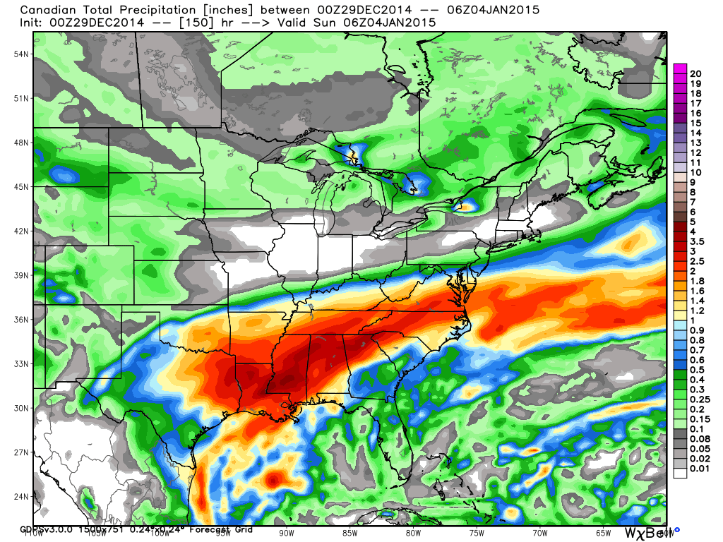
Here is the rainfall totals from the next storm. Once again this is a big rain maker for areas to our south (same as the last storm was)
I did anticipate an active southern jet stream this winter. So far it has not disappointed.

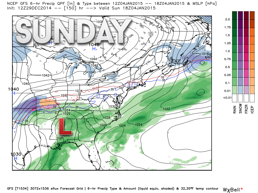
As mentioned above, I am watching a system for Thursday night (late) and Friday/Saturday. An area of low pressure will move out of the Southern Plains into the Mississippi River Valley. This area of low pressure will pull moisture northward into our area.
By Friday afternoon the cold air, that will be in place most of this week, will be shunted north and east. Warmer air will move into our area by Friday afternoon into Saturday.
We might see the precipitation move in quick enough early Friday morning for it to begin as a wintry mix. Warm air, however, is forecast to win out and if there is a wintry mix it won’t last long.
Widespread rain is likely on Friday into Saturday. Still a bit early to know how much rain might fall. If the low does pass close to our area then some areas could pick up an inch or so of precipitation.
The GFS model tracks this sucker pretty far south. Could that mean more wintry precipitation at the end of the storm? This will be one to watch.
All of the above forecast comments are 100% dependent on the storm behaving as expected. Since this system is still several days away it would be best to check back for the latest update. These winter systems can be tricky to forecast.
Colder air will move back into the region by Saturday night or Sunday. This colder air may linger into next week. Some of the data places a decent amount of cold air into our region next week (January 5th-9th). Long way off and plenty of time to monitor.
Some of the long range data indicates a lot of cold air for the very end of January into February. Perhaps sustained cold.
January may bring transient cold shots.
The long range cycle data is leaning towards another system around January 5th through 9th. A lot of cold air behind that one? Possibly.

Please visit your local National Weather Service Office by clicking here. The National Weather Service Office, for our region, is located in Paducah, Kentucky.

Here is the official 6-10 day and 8-14 day temperature and precipitation outlook. Check the date stamp at the top of each image (so you understand the time frame).
The forecast maps below are issued by the Weather Prediction Center (NOAA).


The latest 8-14 day temperature and precipitation outlook. Note the dates are at the top of the image. These maps DO NOT tell you how high or low temperatures or precipitation will be. They simply give you the probability as to whether temperatures or precipitation will be above or below normal.


Many of my graphics are from www.weatherbell.com – a great resource for weather data, model data, and more


This blog was inspired by ABC 33/40’s Alabama Weather Blog – view their blog
Current tower cam view from the Weather Observatory- Click here for all cameras.

Southern Illinois Weather Observatory

The Weather Observatory

Southern Illinois Weather Observatory
WSIL TV 3 has a number of tower cameras. Click here for their tower camera page & Illinois Road Conditions

Marion, Illinois
WPSD TV 6 has a number of tower cameras. Click here for their tower camera page & Kentucky Road Conditions & Kentucky Highway and Interstate Cameras

Downtown Paducah, Kentucky
Benton, Kentucky Tower Camera – Click here for full view

Benton, Kentucky

I24 Paducah, Kentucky

I24 Mile Point 9 – Paducah, KY

I24 – Mile Point 3 Paducah, Kentucky

You can sign up for my AWARE email by clicking here I typically send out AWARE emails before severe weather, winter storms, or other active weather situations. I do not email watches or warnings. The emails are a basic “heads up” concerning incoming weather conditions.