We have some great sponsors for the Weather Talk Blog. Please let our sponsors know that you appreciate their support for the Weather Talk Blog.
Milner and Orr Funeral Home and Cremation Services located in Paducah, Kentucky and three other western Kentucky towns – at Milner and Orr they believe in families helping families. You can find Milner and Orr on Facebook, as well.
![]()
.

Wortham Dental Care located in Paducah, Kentucky. The gentle dentist. Mercury free dentistry. They also do safe Mercury removal. You can find Wortham Dental Care on Facebook, as well
.

For all of your families eye care needs. Visit their web-site here. Or, you can also visit their Facebook page.
.

Endrizzi’s Storm Shelters – For more information click here. Endrizzi Contracting and Landscaping can be found on Facebook, as well – click here
.

Best at Enabling Body Shop Profitability since 1996. Located In Paducah Kentucky and Evansville Indiana; serving all customers in between. They provide Customer Service, along with all the tools necessary for body shops to remain educated and competitive. Click the logo above for their main web-site. You can find McClintock Preferred Finishes on Facebook, as well
.

Duck/goose decoys? Game calls? Optics? We have you covered! Click the logo above or visit Final Flight on Facebook, as well.
.
.
I have launched the new weather texting service! I could use your help. Be sure and sign up and fully support all of the weather data you see each day.
This would make a great Christmas present for someone 🙂
This is a monthly subscription service. Supporting this helps support everything else. The cost is $3 a month for one phone, $5 a month for three phones, and $10 a month for seven phones.
For more information visit BeauDodsonWeather.com
Or directly sign up at Weathertalk.com


This forecast update covers far southern Illinois, far southeast Missouri, and far western Kentucky. See the coverage map on the right side of the blog.
Remember that weather evolves. Check back frequently for updates, especially during active weather.
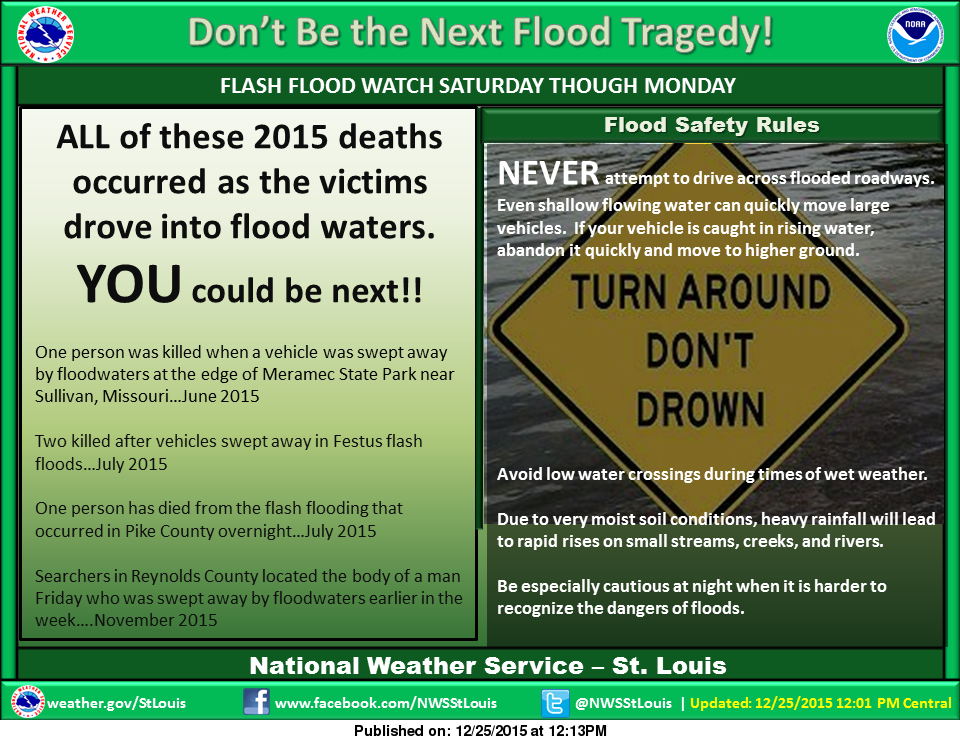
NOTE: VERY heavy rainfall totals are forecast to fall over parts of Missouri and Illinois from Saturday into Monday. A potentially historic rain event is forecast by the St Louis, Missouri National Weather Service office for parts of southwest Missouri into eastern Missouri and then into Illinois.
Large and rapid rises on rivers and streams are possible. There remains some uncertainty about where the largest rainfall totals will fall. Monitor all watches and warnings. Avoid flooded roadways if that becomes a problem.
WEATHER RADAR PAGE – Click here —
Saturday night – A chance for showers and possibly thunderstorms, mainly north of the the front. The southern half of the region may remain dry for the first half of the night. That would include far southern Illinois and western Kentucky. Then, showers and thunderstorms should move southward as the night wears on.
Temperatures: Lows in the upper 50s to lower 60s
Winds: South winds at 10-15 mph and gusty. Winds may switch out of the north and northeast
What is the chance for precipitation? 70% north of the front and 30% south. Showers and storms may redevelop late at night and become more widespread.
Coverage of precipitation? Widespread.
My confidence in this part of the forecast verifying is High
Should I be concerned about snow or ice? No
Should I cancel my outdoor plans? Have a plan B
Is severe weather expected? Monitor updates
What impact is expected? Wet roadways and lightning
Sunday – A chance for showers and thunderstorms. Locally heavy rain possible. There should be a lull in the rain on Sunday afternoon and evening. Before the next batch moves in. Turning colder behind the front as it sags back southward.
Temperatures: Highs in the upper 50s to lower 60s. Falling temperatures behind the front.
Winds: West and southwest winds turning more northerly/northeasterly at 6-12 mph. Winds will vary over the region with a front draping itself across our counties.
What is the chance for precipitation? 80%
Coverage of precipitation? Widespread
My confidence in this part of the forecast verifying is High
Should I be concerned about snow or ice? No
Should I cancel my outdoor plans? Have a plan B and monitor updates.
Is severe weather expected? Monitor updates.
What impact is expected? Wet roadways. Lightning. Heavy rain possible.
Sunday night – Showers. Windy. Thunderstorms also possible. Temperatures will likely rise late at night as the area of low pressure approaches.
Temperatures: Lows in the 40s, but rising into the 50s towards morning. Temperatures may vary quite a bit over the region.
Winds: Northeast winds at 10-20 mph. Gusts above 40 mph possible. Winds will vary depending on which side of the front you are located.
What is the chance for precipitation? 90%
Coverage of precipitation? Widespread
My confidence in this part of the forecast verifying is High
Should I be concerned about snow or ice? No
Should I cancel my outdoor plans? Have a plan B
Is severe weather expected? Monitor updates
What impact is expected? Wet roadways. Some flooding possible in some of our local counties.
Monday – Widespread showers and some thunderstorms. Windy. Temperatures may vary greatly from north to south. Monitor updates.
Temperatures: Highs in the upper 50s to middle 60s, but perhaps much colder over our northern counties. Falling temperatures possible in the afternoon.
Winds: Winds becoming southerly at 10-20 mph. Winds Monday morning (early) could top 40 mph. Winds will vary depending on which side of the front you are located.
What is the chance for precipitation? 90%
Coverage of precipitation? Widespread
My confidence in this part of the forecast verifying is High
Should I be concerned about snow or ice? No
Should I cancel my outdoor plans? Have a plan B and monitor updates.
Is severe weather expected? Monitor updates.
What impact is expected? Wet roadways. Lightning. Heavy rain possible. Some flooding possible in some of our local counties.
Monday night – Rain ending. Gusty winds. Colder.
Temperatures: Lows in the lower to middle 30s.
Winds: Southwest winds at 10-20 mph with gusts above 30 mph possible.
What is the chance for precipitation? 40%
Coverage of precipitation? Scattered
My confidence in this part of the forecast verifying is High
Should I be concerned about snow or ice? No
Should I cancel my outdoor plans? No, but a few showers may remain in the area.
Is severe weather expected? No
What impact is expected? Wet roadways. Potential for large rises on some rivers and streams.
Tuesday – Partly cloudy and colder.
Temperatures: Highs in the upper 30s and lower 40s.
Winds: West winds at 6-12 mph.
What is the chance for precipitation? 0%
Coverage of precipitation? None
My confidence in this part of the forecast verifying is High
Should I be concerned about snow or ice? No
Should I cancel my outdoor plans? No
Is severe weather expected? No
What impact is expected? Rivers and streams may have flooding problems. Large rises on rivers are possible over the coming week.
Some light rain or flurries possible Tuesday night.
Dry Wednesday into Friday. Normal to below normal temperatures as we push into next week. It will feel more like winter.
Click their ad below to visit their web-site or click here reedelec.com


Don’t forget to check out the Southern Illinois Weather Observatory web-site for weather maps, tower cams, scanner feeds, radars, and much more! Click here

An explanation of what is happening in the atmosphere over the coming days…
Highlights
1. Heavy rain is the main concern
2. Flood/flash flood watches cover parts of our area. More counties may be added.
3. Avoid flooded roadways.
WEATHER RADAR PAGE – Click here —
The focus of this update is on the potential for flooding over the next few days. Yet another large rainfall event is forecast from Texas and Oklahoma into the Missouri Valley. One of several this year. These very high PWAT values just keep returning. PWAT values are a measure of moisture in the atmosphere. Some of the readings over the coming days will be 5 standard deviations above normal. This is amazing. And, the concerning part is that these type of readings just keep returning. There are some studies that suggest we may have entered some type of new pattern that is allowing these very high PWAT value events. This has been going on for a number of years.
Large rises are expected on the Mississippi River and perhaps the Ohio River. And, of course, smaller rivers and streams in the heavy rain areas will also flood. Major flooding is forecast on the Mississippi River at Cape Girardeau. Monitor the latest crest forecasts (see links further down in the blog post).
Let’s look at some future-cast radar forecasts. This is what one model suggests radar might look like. I will walk you through Monday.
These graphics are from weatherbell.com Click images for a larger view
This is for 6 pm on Sunday evening. You can see most of the rain has shifted north.

This next image is for Sunday morning at 6 am. You can see the front has shifted back southward. Showers and storms are expected over our area. Some heavy rain likely. This could cause flooding.

This next image is for Sunday evening. Some scattered rain continues. There could be some type of lull on Sunday afternoon and evening. Then more rain moves in as the main storm system shifts east/northeast.

Moving ahead to Monday morning at 6 am. Here comes the main system from the southwest.

Then by Monday evening the system should be departing our region.

The highest risk zone for flooding will be over parts of Missouri and Illinois. But, that doesn’t mean other areas won’t also have problems.
Please avoid flooded roadways.
Gusty winds late Sunday night and Monday morning. We could have some gusts over 40 mph.

Some watches in our region (and perhaps some warnings coming)
Clickable map


Here are the current river stage forecasts. You can click your state and then the dot for your location. It will bring up the full forecast and hydrograph.
Click Here For River Stage Forecasts…

No snow anticipated.

Sunday – No snow or ice anticipated.
Sunday night – No snow or ice anticipated.
Monday – No snow or ice anticipated.
Tuesday – You guessed it. No snow or ice anticipated.
Wednesday – No snow or ice anticipated.

Complex forecast and I continue to fine tune the numbers. The timing of precipitation over our region varies greatly. From northwest to southeast there will be significant rainfall total differences. Keep this in mind.

Heavy rain potential is going to be the big concern over the next 48 hours. Flood/flash flood watches cover a large portion of Missouri and Illinois. Additional counties may be added. See the watch/warning map that I posted above. You can click on it.
The severe weather concerns over the weekend appear small. But, I will continue to monitor this part of the forecast.

Yes, monitor weather updates.
Umbrellas will be necessary Saturday night into Monday.
Monitor the rainfall situation. Some flash flood warnings are possible over the coming two days.

The main wild card will be rainfall totals. Heaviest rain should be over parts of Missouri and Illinois. This is a significant rain event for parts of the Missouri River Valley. Large rises on rivers are likely to occur.

How much precipitation should we expect over the next few days?
Quite a bit of rain expected. This is the NAM model guidance.
Widespread 1.5-3″ over our region. And, can’t rule out some heavier totals. Let’s keep a close eye on it. Some spots in Missouri and Illinois will end up with more.
Officially NOAA has widespread 5-7″ for our region. There are some disagreements among forecasters. I could see some big totals for Missouri and Illinois. Depending on the eventual placement of the front. Again, monitor updates.

Can we expect severe thunderstorms over the next 24 to 48 hours? Remember that a severe thunderstorm is defined as a thunderstorm that produces 58 mph winds or higher, quarter size hail or larger, and/or a tornado.
The thunderstorm threat level will be a ONE on Saturday night into Monday. Some lightning possible. Right now the severe weather risk appears small. However, monitor updates
.
Saturday Night – Monitor updates. Storms are possible
Sunday – Monitor updates. Storms are possible
Monday – Monitor updates. Storms are possible.
Tuesday – Severe weather is not anticipated.
Wednesday through next Friday – No severe weather concerns.

We have regional radars and local city radars – if a radar does not seem to be updating then try another one. Occasional browsers need their cache cleared. You may also try restarting your browser. That usually fixes the problem. Occasionally we do have a radar go down. That is why I have duplicates. Thus, if one fails then try another one.
If you have any problems then please send me an email beaudodson@usawx.com
WEATHER RADAR PAGE – Click here —
We also have a new national interactive radar – you can view that radar by clicking here.
Local interactive city radars include St Louis, Mt Vernon, Evansville, Poplar Bluff, Cape Girardeau, Marion, Paducah, Hopkinsville, Memphis, Nashville, Dyersburg, and all of eastern Kentucky – these are interactive radars. Local city radars – click here
NOTE: Occasionally you will see ground clutter on the radar (these are false echoes). Normally they show up close to the radar sites – including Paducah.


Here is the official 6-10 day and 8-14 day temperature and precipitation outlook. Check the date stamp at the top of each image (so you understand the time frame).
The forecast maps below are issued by the Weather Prediction Center (NOAA).


The latest 8-14 day temperature and precipitation outlook. Note the dates are at the top of the image. These maps DO NOT tell you how high or low temperatures or precipitation will be. They simply give you the probability as to whether temperatures or precipitation will be above or below normal.


Here are the current river stage forecasts. You can click your state and then the dot for your location. It will bring up the full forecast and hydrograph.
Click Here For River Stage Forecasts…

Who do you trust for your weather information and who holds them accountable?
I have studied weather in our region since the late 1970’s. I have 37 years of experience in observing our regions weather patterns. My degree is in Broadcast Meteorology from Mississippi State University and an Associate of Science (AS). I am currently working on my Bachelor’s Degree in Geoscience.
My resume includes:
Member of the American Meteorological Society.
NOAA Weather-Ready Nation Ambassador.
Meteorologist for McCracken County Emergency Management. I served from 2005 through 2015.
I own and operate the Southern Illinois Weather Observatory.
Recipient of the Mark Trail Award, WPSD Six Who Make A Difference Award, Kentucky Colonel, and the Caesar J. Fiamma” Award from the American Red Cross.
In 2009 I was presented with the Kentucky Office of Highway Safety Award.
Recognized by the Kentucky House of Representatives for my service to the State of Kentucky leading up to several winter storms and severe weather outbreaks.
I am also President of the Shadow Angel Foundation which serves portions of western Kentucky and southern Illinois.
There is a lot of noise on the internet. A lot of weather maps are posted without explanation. Over time you should learn who to trust for your weather information.
My forecast philosophy is simple and straight forward.
- Communicate in simple terms
- To be as accurate as possible within a reasonable time frame before an event
- Interact with you on Twitter, Facebook, and the blog
- Minimize the “hype” that you might see on television or through other weather sources
- Push you towards utilizing wall-to-wall LOCAL TV coverage during severe weather events
I am a recipient of the Mark Trail Award, WPSD Six Who Make A Difference Award, Kentucky Colonel, and the Caesar J. Fiamma” Award from the American Red Cross. In 2009 I was presented with the Kentucky Office of Highway Safety Award. I was recognized by the Kentucky House of Representatives for my service to the State of Kentucky leading up to several winter storms and severe weather outbreaks.
If you click on the image below you can read the Kentucky House of Representatives Resolution.

Many of my graphics are from www.weatherbell.com – a great resource for weather data, model data, and more


You can sign up for my AWARE email by clicking here I typically send out AWARE emails before severe weather, winter storms, or other active weather situations. I do not email watches or warnings. The emails are a basic “heads up” concerning incoming weather conditions.