We have some great sponsors for the Weather Talk Blog. Please let our sponsors know that you appreciate their support for the Weather Talk Blog.
Milner and Orr Funeral Home and Cremation Services located in Paducah, Kentucky and three other western Kentucky towns – at Milner and Orr they believe in families helping families. You can find Milner and Orr on Facebook, as well.
![]()
.

Wortham Dental Care located in Paducah, Kentucky. The gentle dentist. Mercury free dentistry. They also do safe Mercury removal. You can find Wortham Dental Care on Facebook, as well
.

For all of your families eye care needs. Visit their web-site here. Or, you can also visit their Facebook page.
.

Endrizzi’s Storm Shelters – For more information click here. Endrizzi Contracting and Landscaping can be found on Facebook, as well – click here
.

Best at Enabling Body Shop Profitability since 1996. Located In Paducah Kentucky and Evansville Indiana; serving all customers in between. They provide Customer Service, along with all the tools necessary for body shops to remain educated and competitive. Click the logo above for their main web-site. You can find McClintock Preferred Finishes on Facebook, as well
.

Duck/goose decoys? Game calls? Optics? We have you covered! Click the logo above or visit Final Flight on Facebook, as well.
.
.
I have launched the new weather texting service! I could use your help. Be sure and sign up and fully support all of the weather data you see each day.
This would make a great Christmas present for someone 🙂
This is a monthly subscription service. Supporting this helps support everything else. The cost is $3 a month for one phone, $5 a month for three phones, and $10 a month for seven phones.
For more information visit BeauDodsonWeather.com
Or directly sign up at Weathertalk.com


This forecast update covers far southern Illinois, far southeast Missouri, and far western Kentucky. See the coverage map on the right side of the blog.
Remember that weather evolves. Check back frequently for updates, especially during active weather.
Wednesday night – Thunderstorms ending. Some clearing.
Temperatures: Lows should drop into the upper 30s and lower 40s over southeast Missouri and southern Illinois and mostly in the 40s over western Kentucky and northwest Tennessee.
Winds: Southwest becoming west/northwest winds at 6-12 mph.
What is the chance for precipitation? Ending from west to east
Coverage of precipitation? Ending
My confidence in this part of the forecast verifying is High
Should I be concerned about snow or ice? No
Should I cancel my outdoor plans? No, but have a plan B in mind early in the evening. Some showers may remain.
Is severe weather expected? Threat will end early in the night.
What impact is expected? All of these concerns will end with the storms exit. Wet roads. Lightning possible. Gusty winds. A chance for a few severe storms early in the evening.
Thursday – Mix of sun and clouds. Mild. Should be a dry day.
Temperatures: Highs from 56-66
Winds: East/southeast winds at 4-8 mph.
What is the chance for precipitation? 0%
Coverage of precipitation? None
My confidence in this part of the forecast verifying is High
Should I be concerned about snow or ice? No
Should I cancel my outdoor plans? No
Is severe weather expected? No
What impact is expected? None
Thursday night – Patchy clouds early and then becoming mostly cloudy. A chance for a shower or thunderstorm
Temperatures: Lows from 38-46
Winds: South/southeast winds at 5 mph becoming northeast at 4-8 mph
What is the chance for precipitation? 30%
Coverage of precipitation? Isolated
My confidence in this part of the forecast verifying is High
Should I be concerned about snow or ice? No
Should I cancel my outdoor plans? No
Is severe weather expected? No
What impact is expected? Perhaps wet roadways. Lightning possible.
Friday – Clouds. Mild. A chance for a few showers. Maybe a rumble of thunder. Low confidence on Friday’s forecast.
Temperatures: Highs in the upper 50s to lower 60s
Winds: East and northeast winds at 8-16 mph. Perhaps gusty at times.
What is the chance for precipitation? 40% – 50%
Coverage of precipitation? Scattered.
My confidence in this part of the forecast verifying is Low/medium
Should I be concerned about snow or ice? No
Should I cancel my outdoor plans? There could be rain on Christmas Day
Is severe weather expected? No
What impact is expected? Perhaps wet roads. Lightning.
Friday night – A chance for showers and possibly thunderstorms.
Temperatures: Lows in the 50s (temps may vary across the region)
Winds: East and southeast winds becoming more south winds at 10-15 mph
What is the chance for precipitation? 60%-80%
Coverage of precipitation? Scattered to widespread
My confidence in this part of the forecast verifying is High
Should I be concerned about snow or ice? No
Should I cancel my outdoor plans? Have a plan B
Is severe weather expected? Monitor updates
What impact is expected? Wet roadways. Lightning.
Large temperature differences are possible over the region Saturday-Monday. This will depend on the placement of a stationary front. North of the front you can expect 40s and 50s. South of the front you can expect at least 60s.
Saturday – A chance for showers and thunderstorms. Warm. Locally heavy rain possible.
Temperatures: Highs in the 68-74 degree range. Very mild.
Winds: South winds at 10-15 mph.
What is the chance for precipitation? 70%
Coverage of precipitation? Widespread
My confidence in this part of the forecast verifying is Medium
Should I be concerned about snow or ice? No
Should I cancel my outdoor plans? Have a plan B and monitor updates. Low confidence.
Is severe weather expected? Monitor updates.
What impact is expected? Wet roadways. Lightning.
Saturday night – A chance for showers and possibly thunderstorms. Some rain could be heavy.
Temperatures: Lows in the upper 50s to lower 60s
Winds: South winds at 10-15 mph
What is the chance for precipitation? 70%
Coverage of precipitation? Widespread
My confidence in this part of the forecast verifying is High
Should I be concerned about snow or ice? No
Should I cancel my outdoor plans? Have a plan B
Is severe weather expected? Monitor updates
What impact is expected? Wet roadways and lightning
Sunday – A chance for showers and thunderstorms. Locally heavy rain possible.
Temperatures: Highs in the 60s.
Winds: West and southwest winds turning more northerly. Winds will vary greatly over the region with a front draping itself across our counties.
What is the chance for precipitation? 70%
Coverage of precipitation? Widespread
My confidence in this part of the forecast verifying is High
Should I be concerned about snow or ice? No
Should I cancel my outdoor plans? Have a plan B and monitor updates.
Is severe weather expected? Monitor updates.
What impact is expected? Wet roadways. Lightning. Heavy rain possible.
Sunday night – Rain likely. Some rain could be heavy.
Temperatures: Lows in the 40s
Winds: Northeast winds at 10-15 mph. Winds could vary across the region.
What is the chance for precipitation? 60%
Coverage of precipitation? Scattered to widespread
My confidence in this part of the forecast verifying is Medium
Should I be concerned about snow or ice? No
Should I cancel my outdoor plans? Rain possible.
Is severe weather expected? Monitor updates
What impact is expected? Wet roadways
Monday – Widespread showers and some thunderstorms.
Temperatures: Highs in the 60s.
Winds: South winds at 10-15 mph. Gusty at times.
What is the chance for precipitation? 70%
Coverage of precipitation? Widespread
My confidence in this part of the forecast verifying is Medium
Should I be concerned about snow or ice? No
Should I cancel my outdoor plans? Have a plan B and monitor updates.
Is severe weather expected? Monitor updates.
What impact is expected? Wet roadways. Lightning. Heavy rain possible.
Click their ad below to visit their web-site or click here reedelec.com


Don’t forget to check out the Southern Illinois Weather Observatory web-site for weather maps, tower cams, scanner feeds, radars, and much more! Click here

An explanation of what is happening in the atmosphere over the coming days…
Highlights
1. Thursday should be dry (at least we have that)
2. Heavy rain possible Friday into Monday. Some questions remain on timing and placement
3. Potential for strong storms this weekend?
4. Large temperature differences ahead of and behind a frontal system Friday into Monday. Tricky forecasting.
Short update today because of the severe weather outbreak.
The main concern after our thunderstorm event on Wednesday evening will be the potential for a heavy rain event on Friday into Monday night.
There is some debate about Friday’s forecast. Especially during the day. But, either way rain looks like as we push into Friday night and then the weekend. Some of the models are showing big big totals. In excess of 4″. Some even show greater than 6″. This needs to be closely monitored over the coming days.
Some storms could be strong on Friday night and Saturday. But, the confidence is low.
This is a highly unusual weather pattern for December. I personally have never seen anything like it. The longevity of it.
This is the GFS forecast rainfall totals through Monday. Keep in mind this ins one models opinion. This can change. However, the trend has been towards a heavy rain event. Which concerns me a bit. Let’s keep monitoring.
Click image a larger view. That is a widespread area of 3.5 to 7″ of rain. Again, one models opinion.

Here is the official NOAA outlook
Click to enlarge


No snow anticipated.

Thursday – No snow or ice anticipated.
Friday – No snow or ice anticipated.
Saturday – No snow or ice anticipated.
Sunday – No snow or ice anticipated.
Monday – No snow or ice anticipated.

Still working with the probabilities of rainfall over the coming days. Wide range of temperatures ahead of and behind the stationary front Friday into Monday. We could see a 20-30 degree difference in temperatures from our northwest counties to our southeast counties. This will make for tricky forecasting. Keep this in mind.

Heavy rain potential Friday into Monday night is my main concern. A second concern might be the potential for some strong storms over the weekend and/or on Monday as an area of low pressure passes to our northwest. Closely monitor updated forecasts.

Yes, monitor weather updates.
Umbrellas might be needed Friday into Monday night. And, I can’t rule out some flooding issues over the weekend. Let’s keep a close eye on the weather forecast. A prolonged rain event is possible Friday into Monday night. Several inches of rain possible. Monitor creek levels.

Lot of wild cards in the forecast! How much rain falls between Friday into Monday night.
Does rain fall on Christmas Day or does it hold off until Christmas night.
Will there be severe storms this weekend with the warm and humid air over the region.
Lot of weather to monitor and not a straight forward forecast on rainfall totals. We could see 1-3″ area wide between Friday into Monday night. Pockets of much higher totals on some models. Monitor updates

How much precipitation should we expect over the next few days?
This is a lot of rain, folks. Click image for a larger view. This is through Monday night. Potential of several inches of rain.


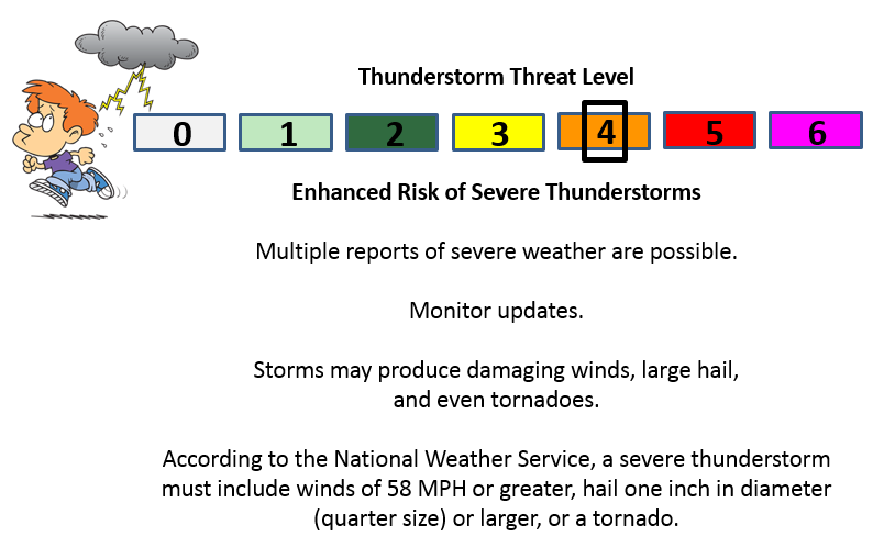
Can we expect severe thunderstorms over the next 24 to 48 hours? Remember that a severe thunderstorm is defined as a thunderstorm that produces 58 mph winds or higher, quarter size hail or larger, and/or a tornado.
The thunderstorm threat level will be a FOUR on Wednesday into Wednesday evening. Then a ONE Friday through Monday (subject to changes)
.
Wednesday into Wednesday Evening– Some severe weather possible
Thursday – Severe weather is not anticipated
Friday – Severe weather is not anticipated. Lightning possible.
Saturday – Monitor updates. Storms are possible
Sunday – Monitor updates. Storms are possible
Monday – Monitor updates. Storms are possible.


We have regional radars and local city radars – if a radar does not seem to be updating then try another one. Occasional browsers need their cache cleared. You may also try restarting your browser. That usually fixes the problem. Occasionally we do have a radar go down. That is why I have duplicates. Thus, if one fails then try another one.
If you have any problems then please send me an email beaudodson@usawx.com
WEATHER RADAR PAGE – Click here —
We also have a new national interactive radar – you can view that radar by clicking here.
Local interactive city radars include St Louis, Mt Vernon, Evansville, Poplar Bluff, Cape Girardeau, Marion, Paducah, Hopkinsville, Memphis, Nashville, Dyersburg, and all of eastern Kentucky – these are interactive radars. Local city radars – click here
NOTE: Occasionally you will see ground clutter on the radar (these are false echoes). Normally they show up close to the radar sites – including Paducah.


Here is the official 6-10 day and 8-14 day temperature and precipitation outlook. Check the date stamp at the top of each image (so you understand the time frame).
The forecast maps below are issued by the Weather Prediction Center (NOAA).


The latest 8-14 day temperature and precipitation outlook. Note the dates are at the top of the image. These maps DO NOT tell you how high or low temperatures or precipitation will be. They simply give you the probability as to whether temperatures or precipitation will be above or below normal.


Here are the current river stage forecasts. You can click your state and then the dot for your location. It will bring up the full forecast and hydrograph.
Click Here For River Stage Forecasts…

Who do you trust for your weather information and who holds them accountable?
I have studied weather in our region since the late 1970’s. I have 37 years of experience in observing our regions weather patterns. My degree is in Broadcast Meteorology from Mississippi State University and an Associate of Science (AS). I am currently working on my Bachelor’s Degree in Geoscience.
My resume includes:
Member of the American Meteorological Society.
NOAA Weather-Ready Nation Ambassador.
Meteorologist for McCracken County Emergency Management. I served from 2005 through 2015.
I own and operate the Southern Illinois Weather Observatory.
Recipient of the Mark Trail Award, WPSD Six Who Make A Difference Award, Kentucky Colonel, and the Caesar J. Fiamma” Award from the American Red Cross.
In 2009 I was presented with the Kentucky Office of Highway Safety Award.
Recognized by the Kentucky House of Representatives for my service to the State of Kentucky leading up to several winter storms and severe weather outbreaks.
I am also President of the Shadow Angel Foundation which serves portions of western Kentucky and southern Illinois.
There is a lot of noise on the internet. A lot of weather maps are posted without explanation. Over time you should learn who to trust for your weather information.
My forecast philosophy is simple and straight forward.
- Communicate in simple terms
- To be as accurate as possible within a reasonable time frame before an event
- Interact with you on Twitter, Facebook, and the blog
- Minimize the “hype” that you might see on television or through other weather sources
- Push you towards utilizing wall-to-wall LOCAL TV coverage during severe weather events
I am a recipient of the Mark Trail Award, WPSD Six Who Make A Difference Award, Kentucky Colonel, and the Caesar J. Fiamma” Award from the American Red Cross. In 2009 I was presented with the Kentucky Office of Highway Safety Award. I was recognized by the Kentucky House of Representatives for my service to the State of Kentucky leading up to several winter storms and severe weather outbreaks.
If you click on the image below you can read the Kentucky House of Representatives Resolution.

Many of my graphics are from www.weatherbell.com – a great resource for weather data, model data, and more


You can sign up for my AWARE email by clicking here I typically send out AWARE emails before severe weather, winter storms, or other active weather situations. I do not email watches or warnings. The emails are a basic “heads up” concerning incoming weather conditions.