Afternoon and evening blog update…
No changes from this mornings post. Still appears to be a very long shot at accumulating snow over parts of eastern Missouri and parts of southern Illinois. The area I outlined this morning still stands at least a chance for some minor accumulation and flakes in the air.
Otherwise, everything else seems on track – rain tonight and windy conditions developing late tonight into Wednesday. Falling temperatures, as well.
We have our first sponsor for the blog. Milner and Orr Funeral Home and Cremation Services located in Paducah, Kentucky and three other western Kentucky towns – at Milner and Orr they believe in families helping families.
![]()

This forecast update covers far southern Illinois, far southeast Missouri, and far western Kentucky. See the coverage map on the right side of the blog.
Tuesday – Morning thick fog for parts of the area will mix out by 10 am. Mostly cloudy sky conditions. We will have on and off chances for showers. It will be mild for the end of December. High temperatures will be in the 50’s. Winds will mostly be out of the southwest at 10-15 mph.
Tuesday night – Cloudy and turning colder. Rain likely. Rain may turn to snow over parts of the area late tonight. Temperatures will fall through the 40’s and perhaps into the upper 30’s by Wednesday morning. Temperatures may remain in the 40’s longer for areas to the east of the area of low pressure. Winds will be out of the north at 10-20 mph.
Wednesday – Cloudy and windy at times. A good chance for rain and perhaps snow showers. Temperatures will fall through the day. A small area of milder temperatures could push into parts of Kentucky along the path of the area of low pressure – during the morning hours. Behind the low we will see temperatures fall into the 30’s over much of the area by the afternoon. Northwest winds at 10-25 mph. Winds will be gusty at times.
Wednesday night – Mostly cloudy. A few flurries possible. Colder. Low temperatures will be in the upper 20’s and lower 30’s. Northwest winds at 10-20 mph during the evening and decreasing to 10-15 mph late.
Christmas – Becoming sunny. Cool, but seasonable for December. High temperatures will be in the 40’s.

Current Temperatures Around The Local Area

National Temperature Map – you can see the warmer air being pulled northward ahead of our next storm system that will approach the area later today and tonight.

Clouds and more clouds and the more clouds. Never ending clouds! So it seems over the past few weeks for much of the United States.


An explanation of what is happening in the atmosphere over the coming days.
Well, welcome to the day before Christmas Eve. I suppose this should be a straight forward forecast, but like everything this week…nothing comes easy!
I am placing a medium confidence on today’s forecast and tonight’s. I am placing a low confidence on tomorrow’s forecast.
A complicated weather set-up for the next 48 hours.
Another area of low pressure will develop today well to our south. Tonight, this area of low pressure will move northward into the Tennessee Valley. As the low moves northward it will pull another slug of moisture into our region. Yes, that means more rain! Much needed rain, I might add.
If you have followed my Facebook Page and weather blog then you should know that an area of low pressure rotates counter-clockwise. That means if you are on the north or west side of the low that you are typically in the cool or cold sector of the storm. If you are to the east of the low then you are normally in the warm sector.
Let me illustrate this with a temperature forecast map for later tonight and Wednesday morning.
See the colder temperatures behind the area of low pressure and the warmer air being pulled up in front of the area of low pressure? The red L is the area of low pressure.
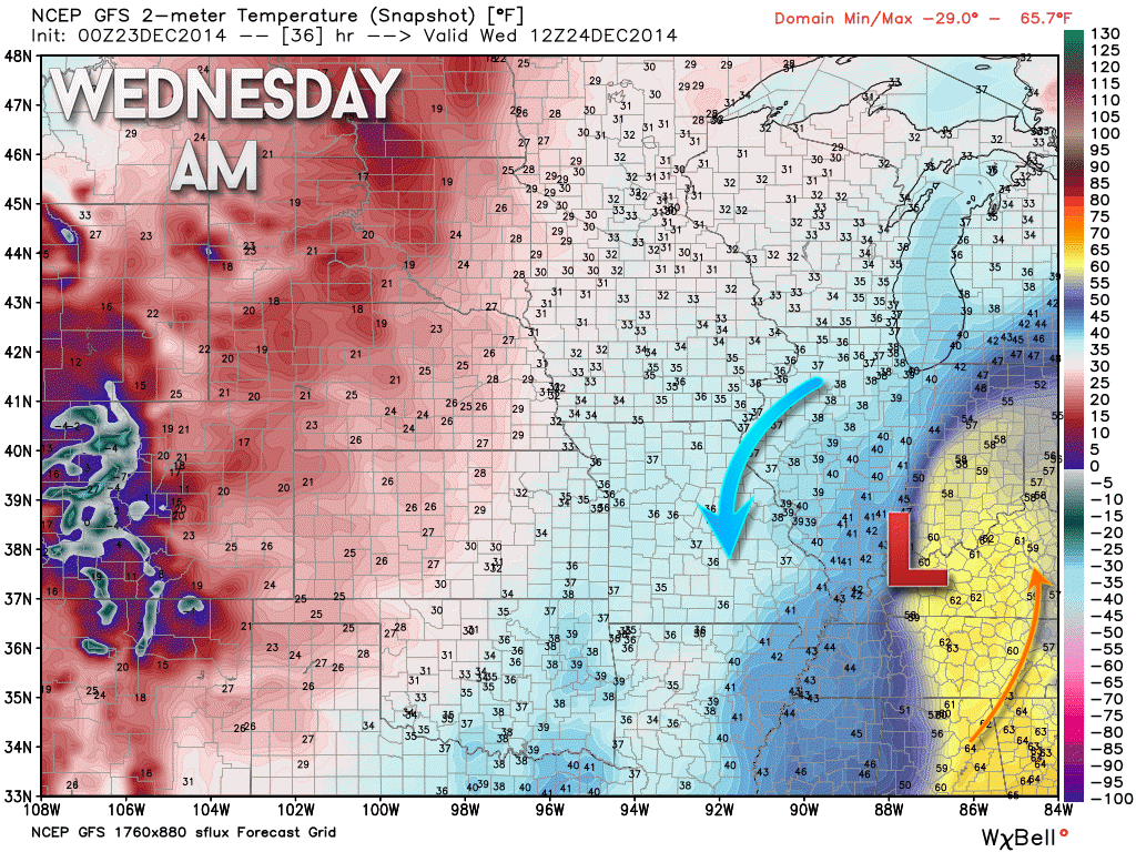
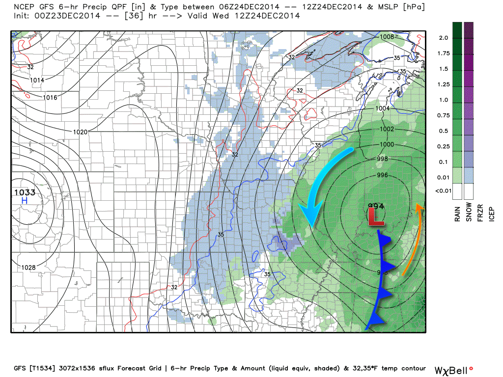
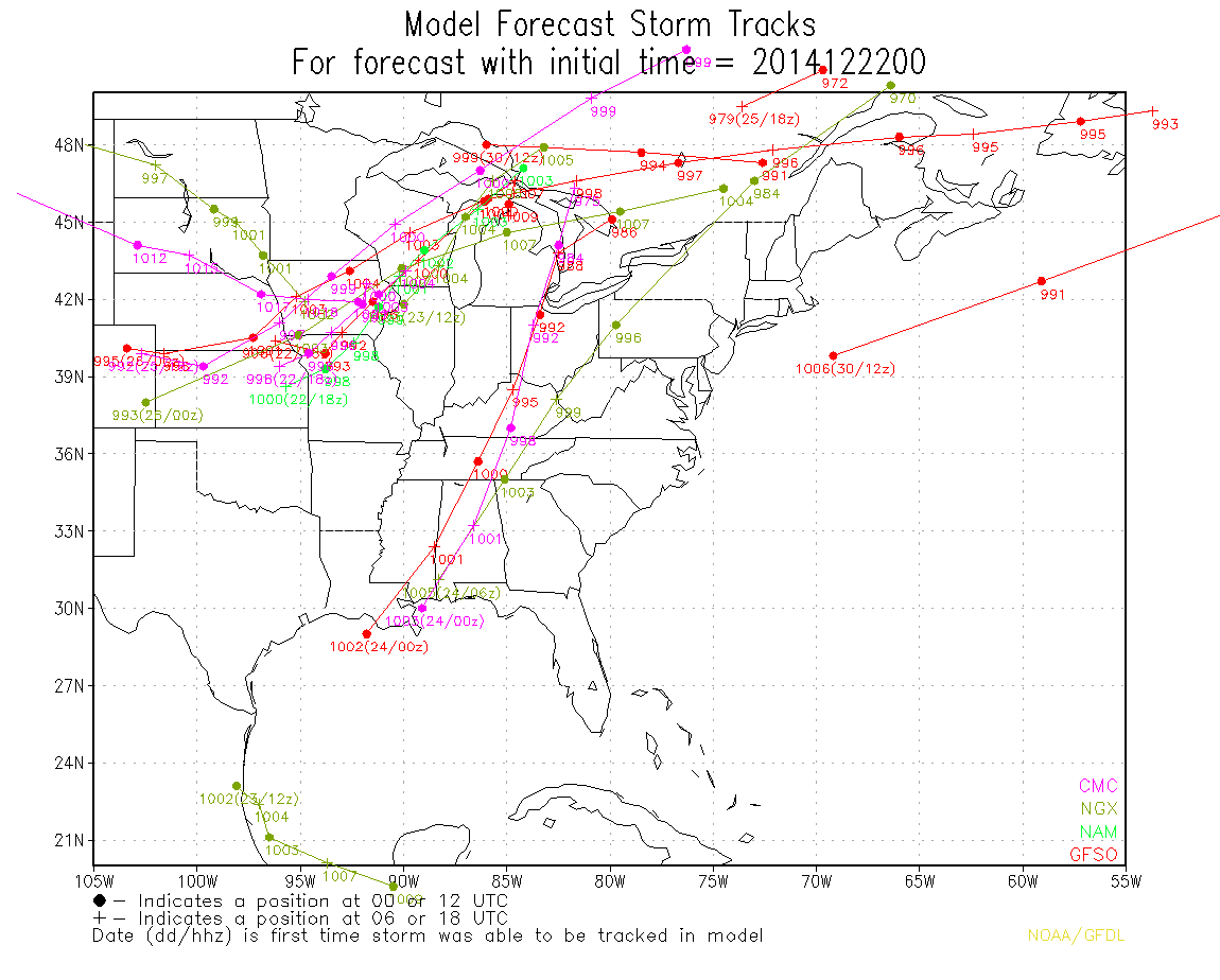
This particular low will likely push just a tad to our east. Perhaps it will pass through middle Tennessee and into middle Kentucky. The low will be moving northward into Indiana. The GFS model (above) shows the low passing into parts of western Kentucky and southwest Indiana. We will have to see if it is actually that far west. Some debate on that particular subject.
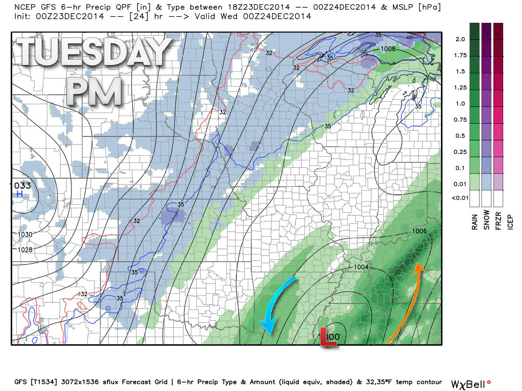
Here is what the GFS model is showing for the track of the area of low pressure. I believe the GFS is a bit too far west with the track. It is more likely to track into central Tennessee and Central Kentucky and then up into Indiana. But, I want to at least show you the general area the low will pass into and the precipitation associated with it.
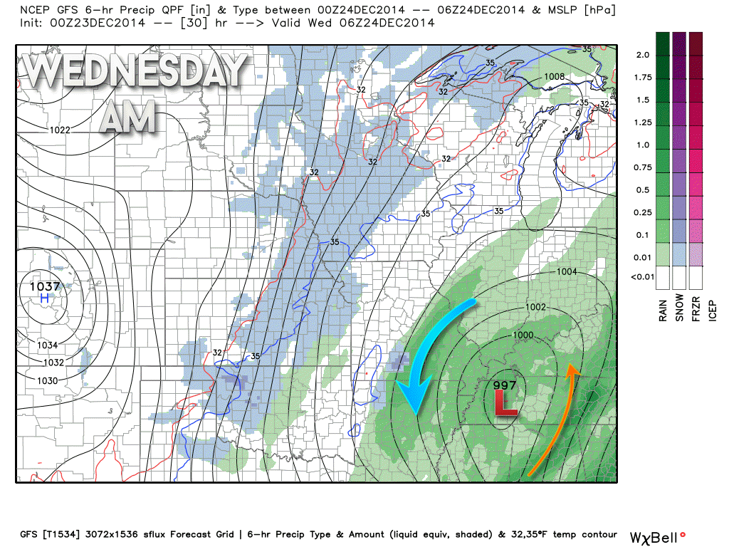
This is for later tonight into Wednesday morning. The low will be deepening as it moves northward. This will cause gusty winds to develop over our area later tonight and into Wednesday morning.
If the low tracks a bit further east then the cold air will work its way into our region a bit faster. That would change the rain over to a bit of snow.
Here is what the ensembles are showing for the track of the area of low pressure – the more tightly clustered these lines are then the more confidence on where the low should track.
Those lines probably look like a bunch of gobaldy-goop to most of you. Let me explain what this is. Computer weather models are run all day long. We have what are called ensembles. They are the same computer model run over and over again (but each time they are tweaked just a little bit different). The idea is that the more of those models runs that agree the more confidence a forecaster has in the eventual outcome.
The map below shows you all of the ensemble members for the track of the area of low pressure that I have been talking about. Again, the tighter the clustering of the lines the more confidence I have in the eventual track of the storm.
The lines are fairly tightly clustered together over western and central Kentucky.
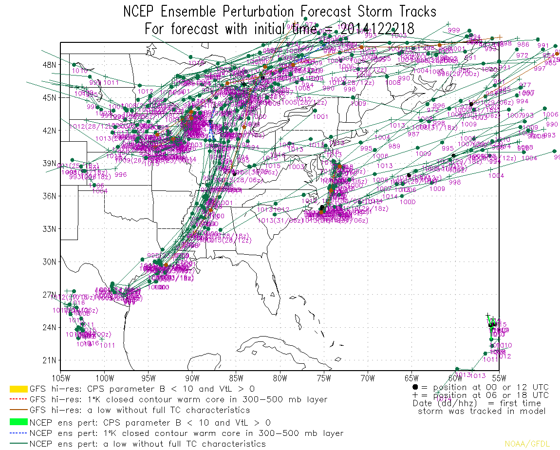
There are, however, some outliers as to where this storm will track. Most noticeable is this track as some other forecasters have pointed out. This track is quite a bit further east.
Tough call on where exactly this area of low pressure tracks. Unfortunately, the track really is key to our sensible weather conditions (what actually happens later tonight and Wednesday morning). I wish I had more confidence on where the low will track.
A couple of factors could contribute to our area receiving a bit of snow from this system…
1. If the low tracks further east than expected
2. If the low is deeper (more intense) than anticipated. That would cause a deformation zone to form in a bit more organized manner and would be able to basically create a cold air pocket in or near our region.
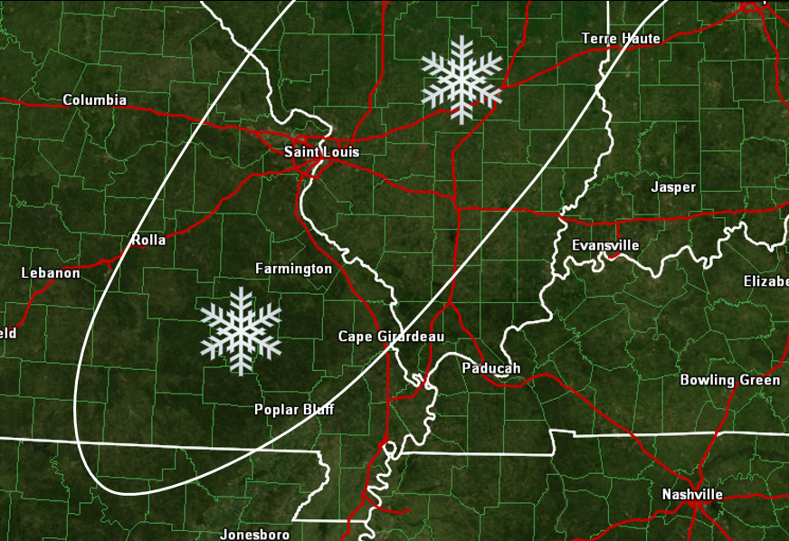
Right now I am not overly confident on this system producing snow in our region. If it were to happen then it would most likely be over parts of eastern Missouri into parts of central and southern Illinois.
This is where I have drawn in the possibility of snow later tonight and Wednesday morning. Not saying areas outside of this won’t see some flakes in the air, as well. This is where the snow could fall a bit heavier at times. Again, low confidence in this part of the forecast.
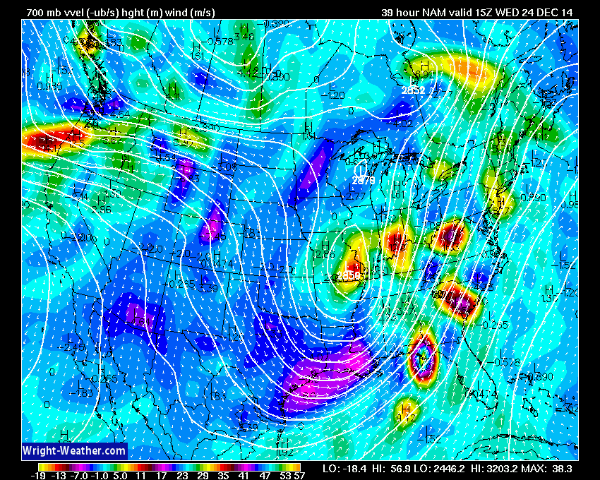
Forecasters like to track the 700 mb low when it comes to forecasting snow. Currently the data shows the 700 mb low tracking through parts of eastern Missouri into the northern parts of southern Illinois. Along this track there could be some snow late tonight into Wednesday.
Here is the NAM depicting the 700 mb low (this is higher up in the atmosphere)
See the bright red colors over southeast Missouri? That is the low.
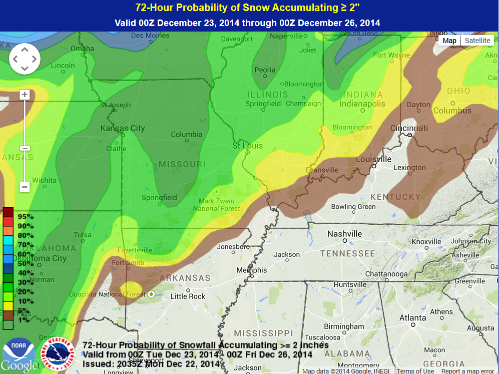
Here is the official NOAA probability map showing where 1″-2″ of snow could fall. Notice that the colors in our area are very low probabilities. They are not zero, but they are also not much above 10%. Generally speaking the brown area represent a 1%-5% chance and the yellow area represents a 5% to 10% chance.
Once again, a lot of things would have to come together just right for the snow to accumulate later tonight and tomorrow.
That map will be updated a couple of times today. I will try to update the blog (watch for an update at the top of the blow) later today.
So, if you twist my arm and ask me “if there a way for this system to produce snow in our region” – well, I would have to answer that question with a yes. But, it was a yes because you twisted my arm.
Keep in mind that road temperatures are quite warm (once again) and with the recent rainfall the ground is wet. The snow would have to come down quite hard in order for it to accumulate. It is a long shot, but for you die-hard snow fanatics I suppose there is at least a small chance for some snow later tonight and on Christmas Eve.
Christmas Day should bring some sunshine to the region. Temperatures will rise into the 40’s. Not a bad day.
Watching another couple of systems as we push into the weekend and next week. Rain or snow? I knew you were going to ask that question. Stay tuned.

The forecast has been tweaked and adjusted several times over the last few days. Struggling with temperatures across our area as the area of low pressure passes to our east. I have adjusted temperatures to where I believe they will be over the next 48 hours. Areas to the east of the low will be the warmest and areas to the west of the low will be the coldest. Keep that in mind. If the low passes over our area then there will be quite the temperature spread from west to east.

Mostly concerned about the possibility of rain changing to snow over some of our counties. Although the overall concerns are limited because of warm road conditions and wet ground conditions.

The wild card tells you where the most uncertainty is in the current forecast.
Wild card in this forecast – do I even need to type out the wild card on this one? Obviously the wild card is squarely going to land on whether or not we will see some snow by late tonight or Wednesday morning. Roll those dice!

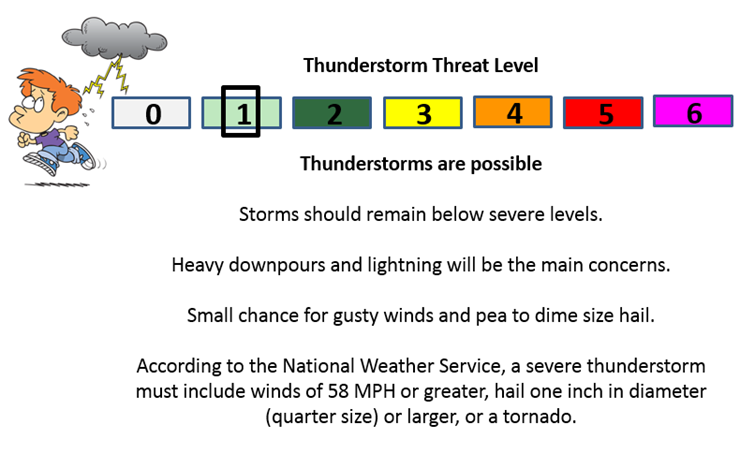
Can we expect severe thunderstorms over the next 24 to 48 hours? Remember that a severe thunderstorm is defined as a thunderstorm that produces 58 mph winds or higher, quarter size hail or larger, and/or a tornado.
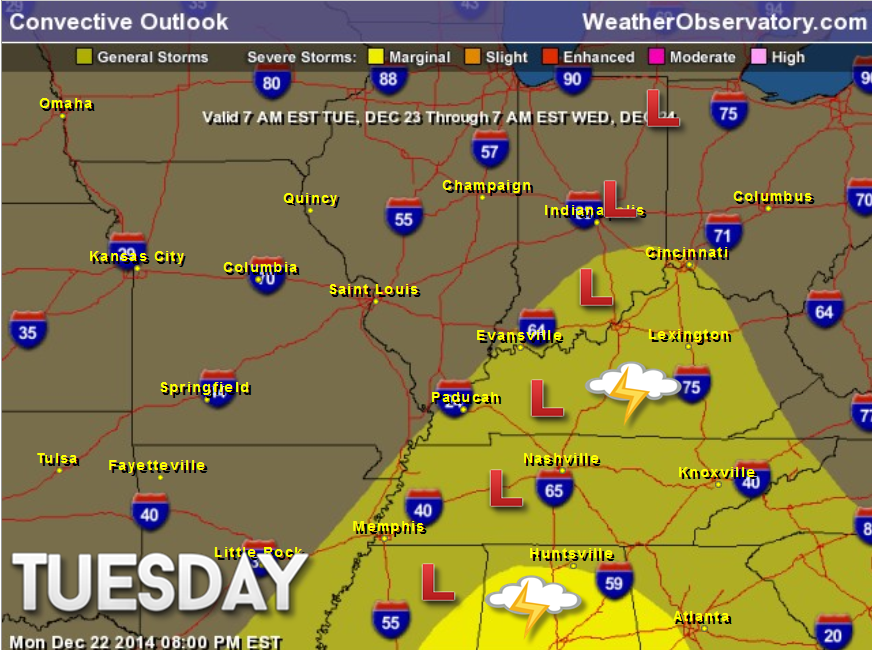
Thunderstorm threat level is ONE. Some thunderstorms will be possible later tonight and on Wednesday morning to the east of the area of low pressure. This would most likely be parts of western Kentucky. Perhaps along and east of a line from Evansville to the Land Between the Lakes.
This map below gives you a rough idea. It could be a tad east of where this map shows (again, highly dependent on where the area of low pressure tracks). I have drawn in where I believe the low will track.
The yellow area represents where general storms could occur.
The bright yellow in Mississippi and Alabama is where a few storms could become severe.

Will I need to take action?
Monitor updates in case the colder air arrives faster. Otherwise, umbrellas will once again be in order over the next 24-36 hours.

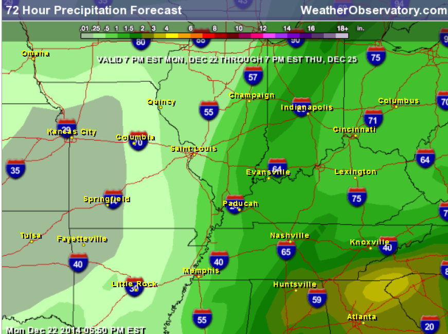
How much rain should this system produce over our region?
The system later today into Wednesday will produce quite a bit of rain over the area. Some moderate downpours are possible. Scale is at the top of the image. Some places could pick up an inch of rain.

Well, here we are again. Once again we are wondering whether or not it might snow in the area. For you snow lovers you must wish you lived 400 miles further north. At least then the forecast would be a bit more straight forward.
Nothing is ever easy around here when it comes to forecasting snow.
I can’t say much more than I have said above. There is at least a chance some of our counties could see the rain change to snow later tonight and on Wednesday morning.
I have seen it happen before with systems like this. Especially true where the area of low pressure deepens more than anticipated. The placement of the snow would be most likely across parts of Missouri and Illinois. See the map I created at the top of the blog.
I will promise to update the blog if it appears there are going to be changes in the forecast.
Beau said “it’s a long shot”


Watching another system towards the weekend. This one might have more cold air to work with. Stay tuned.

We have regional radars and local city radars – if a radar does not seem to be updating then try another one. Occasional browsers need their cache cleared. You may also try restarting your browser. That usually fixes the problem. Occasionally we do have a radar go down. That is why I have duplicates. Thus, if one fails then try another one.
If you have any problems then please send me an email beaudodson@usawx.com
WEATHER RADAR PAGE – Click here —
We also have a new national interactive radar – you can view that radar by clicking here.
Local interactive city radars include St Louis, Mt Vernon, Evansville, Poplar Bluff, Cape Girardeau, Marion, Paducah, Hopkinsville, Memphis, Nashville, Dyersburg, and all of eastern Kentucky – these are interactive radars. Local city radars – click here
NOTE: Occasionally you will see ground clutter on the radar (these are false echoes). Normally they show up close to the radar sites – including Paducah.

Regional Radar – Click on radar to take you our full radar page.


Regional Radar

Live Lightning Data – zoom and pan: Click here
Live Lightning Data with sound (click the sound button on the left side of the page): Click here


Day 1 Severe Weather Outlook from the Storm Prediction Center – Storm Prediction Center
What does thunderstorms, marginal, slight, enhanced, medium, and high risk mean? Click here

Current Severe thunderstorm and tornado watches from the Storm Prediction Center. The Storm Prediction Center is in charge of issuing watches. Our local National Weather Service Office in Paducah, Kentucky is in charge of issuing warnings.
Remember that a watch means that conditions are favorable for severe weather. Severe weather MIGHT develop over the coming hours. Watches normally last 4 to 8 hours. Monitor updates for possible warnings. A watch is a step below a warning.
A warning means to take immediate action to protect you and your family. Warnings usually last from 15 to 45 minutes. A warning means that a storm is moving into your area.
For additional watch information click here


Current WARNINGS (a warning means take action now). Click on your county to drill down to the latest warning information. Keep in mind that there can be a 2-3 minute delay in the updated warning information.
I strongly encourage you to use a NOAA Weather Radio or warning cell phone app for the most up to date warning information. Nothing is faster than a NOAA weather radio.


Color shaded counties are under some type of watch, warning, advisory, or special weather statement. Click your county to view the latest information.

Missouri Warnings

Illinois Warnings

Kentucky Warnings

Please visit your local National Weather Service Office by clicking here. The National Weather Service Office, for our region, is located in Paducah, Kentucky.

Here is the official 6-10 day and 8-14 day temperature and precipitation outlook. Check the date stamp at the top of each image (so you understand the time frame).
The forecast maps below are issued by the Weather Prediction Center (NOAA).


The latest 8-14 day temperature and precipitation outlook. Note the dates are at the top of the image. These maps DO NOT tell you how high or low temperatures or precipitation will be. They simply give you the probability as to whether temperatures or precipitation will be above or below normal.


Many of my graphics are from www.weatherbell.com – a great resource for weather data, model data, and more


This blog was inspired by ABC 33/40’s Alabama Weather Blog – view their blog
Current tower cam view from the Weather Observatory- Click here for all cameras.

Southern Illinois Weather Observatory

The Weather Observatory

Southern Illinois Weather Observatory
WSIL TV 3 has a number of tower cameras. Click here for their tower camera page & Illinois Road Conditions

Marion, Illinois
WPSD TV 6 has a number of tower cameras. Click here for their tower camera page & Kentucky Road Conditions & Kentucky Highway and Interstate Cameras

Downtown Paducah, Kentucky
Benton, Kentucky Tower Camera – Click here for full view

Benton, Kentucky

I24 Paducah, Kentucky

I24 Mile Point 9 – Paducah, KY

I24 – Mile Point 3 Paducah, Kentucky

You can sign up for my AWARE email by clicking here I typically send out AWARE emails before severe weather, winter storms, or other active weather situations. I do not email watches or warnings. The emails are a basic “heads up” concerning incoming weather conditions.