We have our first sponsor for the blog. Milner and Orr Funeral Home and Cremation Services located in Paducah, Kentucky and three other western Kentucky towns – at Milner and Orr they believe in families helping families.
![]()

This forecast update covers far southern Illinois, far southeast Missouri, and far western Kentucky. See the coverage map on the right side of the blog.
Monday – Mostly cloudy with showers developing. Periods of showers through the afternoon hours. High temperatures will be in the 48 to 54 degree range. Winds will pick up a bit from the southeast at 10-20 mph. Rain chances will be 60%-70%
Monday night – Cloudy with showers likely. Temperatures will hold steady through the night. Overnight lows will be in the upper 40’s. South winds at 10-15 mph. Rain chances 60%-70%
Tuesday – Cloudy with a chance for a few showers. High temperatures will be in the upper 40’s and lower 50’s. Winds out of the southwest at 10 mph. Chance of rain 30%.
Very low confidence in the Tuesday night and Wednesday forecast. This part of the forecast is HIGHLY dependent on the evolution of an area of low pressure to our south during Tuesday afternoon and evening.
Tuesday night – Cloudy with a chance for rain. Turning colder late. Rain may mix with snow. Temperatures falling into the 30’s. West winds at 10-15 mph. Chance of precipitation 60%
Wednesday – Cloudy and colder. A chance for rain and snow. Steady temperatures in the 30’s. Chance of precipitation will be 60%
Wednesday night – Whatever precipitation is leftover will come to an end. Lows in the upper 20’s and lower 30’s
Christmas Day – Partly sunny, cool, and dry. Highs in the upper 30’s to lower 40’s.

Current Temperatures Around The Local Area


An explanation of what is happening in the atmosphere over the coming days.
Today is a travel day for me. Under the weather with a bad cold. Hopefully it will pass quickly. Either way, I am heading home to visit family for the holidays.
A complicated weather pattern is shaping up for the next 48-72 hours. There are major differences in the model data as to how to handle a second area of low pressure on Tuesday evening into Wednesday morning.
First things first…
Showers will develop today and spread over the area. At one time it appeared that today’s activity would only be scattered. It now appears that activity will be a bit more widespread. Rain will continue into tonight. There could even be a rumble of thunder.
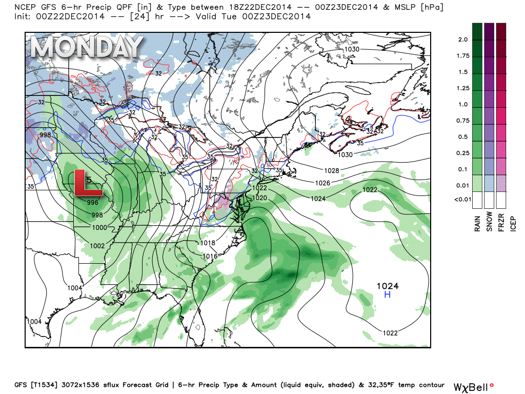
Here is what that low looks like later today as it pulls well off to our north – widespread rain into our region (the green colors).
A second area of low pressure will develop somewhere to our south on Tuesday afternoon and night. As this low pulls north/northeast we may see additional rain spread back into the area on Tuesday night and Wednesday morning. At the same time colder air will be advancing into the area from the west. Depending on how fast the cold air arrives we may see the rain change to a brief period of light snow before it comes to an end.
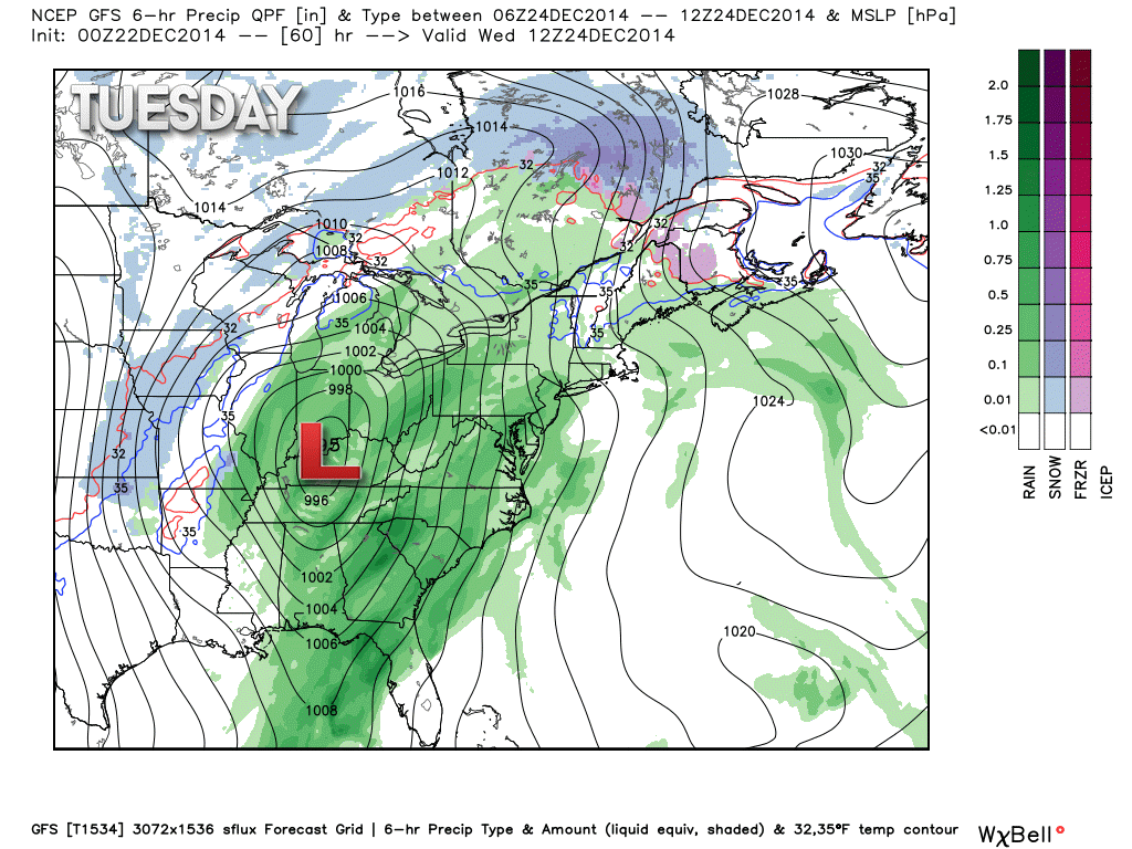
Here is what the GFS model shows for the second storm system – the GFS is probably one of the deeper and stronger storms vs the other models. Although this can’t be completely discounted it does seem the more likely solution would be for the low to be a bit further east. We will see.
I will update later today or tonight. Bottom line is that more rain is possible Tuesday night and perhaps ending as snow on Wednesday. If the snow were to come down heavier enough in a few spots then some light accumulation is not totally out of the question. This seems questionable given the wet ground conditions. If this were to happen then somewhere over eastern Missouri and perhaps southern Illinois would have the best chance of that happening. A lot of this depends on the track of the low and precipitation rates on Wednesday.
I am sure that the Tuesday night into Wednesday forecast will change before all is said and done. Right now it does not appear that there will be any travel problems during this time frame. Again, even if the rain changes to snow it is not forecast to be enough to cause travel problems.
Christmas Day should be colder and dry.
I have moved the graphics around on the page. You will find most of your storm tracking tools and links towards the bottom of the blog. The top half of the blog will be my commentary, comments, and forecast thoughts.

I adjusted temperatures a bit on Tuesday night and Wednesday. I have very little confidence in the forecast during that time frame. It is not very often that the forecast in the short range is so uncertain.
I also adjusted rain chances today (increased them). I lowered rain chances during the 6 am to 6 pm time frame on Tuesday.

No major concerns at this time.

The wild card tells you where the most uncertainty is in the current forecast.
Wild card in this forecast – there are so many wild cards in the forecast that I am not sure I can cover them all. The main concern will be centered around rain chances during the day on Tuesday and then the second area of low pressure that is forecast to form on Tuesday night. Low confidence all the way around.
Also the wild card will be whether the rain will change to snow on Wednesday.

Can we expect severe thunderstorms over the next 24 to 48 hours? Remember that a severe thunderstorm is defined as a thunderstorm that produces 58 mph winds or higher, quarter size hail or larger, and/or a tornado.
Thunderstorm threat level is 1 – that means that some rumbles of thunder will be possible. Storms should not reach severe levels. Gusty winds would be possible if a thunderstorm does form.
Historically systems like this produce severe weather (in our area). This system, however, does not have much instability to work with. If that were to change then severe weather chances would increase. At this time, that does not appear to be a concern.


Will I need to take action?
Other than umbrellas, no.

How much rain should this system produce over our region?
The rain forecast is 100% dependent on where the second low forms on Tuesday evening and night. I have no confidence in this part of the forecast. Rain totals would increase quite a bit if that low tracks near our region. If it does not track near our region then rain totals would be considerably lower.
Let me try and break this down a bit more for you
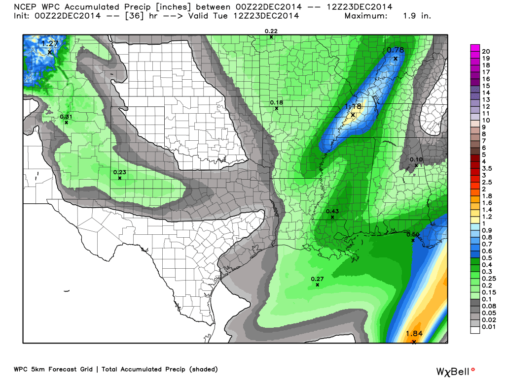
This is the expected rainfall totals through 6 am on Tuesday morning – this is from the first storm system. You can see a small band of heavier totals across some of our counties. The scale is on the right side of the page.
We will see how those higher totals pan out. Sometimes it is hard to pinpoint exactly where the heavier totals will verify. For now that is the current thinking.
Generally I have been thinking that most areas should pick up around 0.50″ of rain Monday into Monday night/Tuesday morning. Obviously the data is showing some areas picking up more than that. Again, we will see how this goes. We could use the rain.
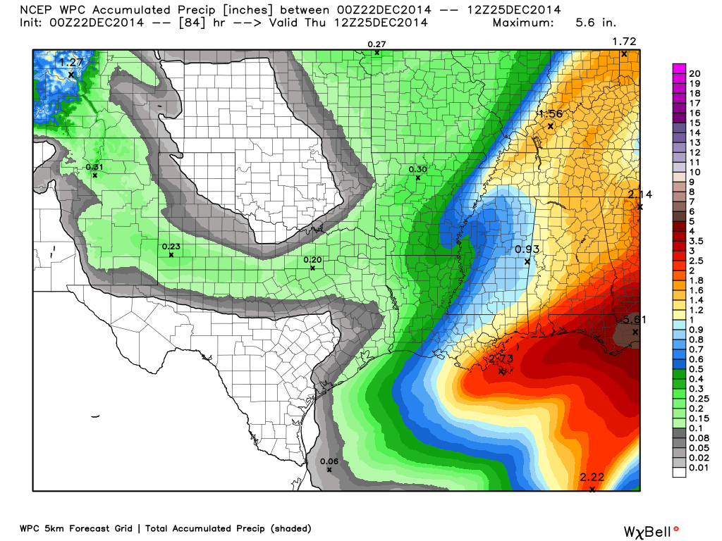
This second map is 100% dependent on the second area of low pressure developing and producing additional rain. If that second low does not form or is further east then the rain totals will change.

Okay, snow fans you have got to be pulling your hair out by now. I don’t have any good news for you. Colder air may filter in late Tuesday night and on Wednesday. If this colder air arrives soon enough then perhaps the rain will mix with or change to a brief period snow.
I will keep monitoring.

The long range data continues to point towards a colder air mass as we move into next week (the last week of December) and the first week of January. Too soon to know if we can pull some moisture into that cold air mass.
Radars and storm tracking tools can be found below.

We have regional radars and local city radars – if a radar does not seem to be updating then try another one. Occasional browsers need their cache cleared. You may also try restarting your browser. That usually fixes the problem. Occasionally we do have a radar go down. That is why I have duplicates. Thus, if one fails then try another one.
If you have any problems then please send me an email beaudodson@usawx.com
WEATHER RADAR PAGE – Click here —
We also have a new national interactive radar – you can view that radar by clicking here.
Local interactive city radars include St Louis, Mt Vernon, Evansville, Poplar Bluff, Cape Girardeau, Marion, Paducah, Hopkinsville, Memphis, Nashville, Dyersburg, and all of eastern Kentucky – these are interactive radars. Local city radars – click here
NOTE: Occasionally you will see ground clutter on the radar (these are false echoes). Normally they show up close to the radar sites – including Paducah.

Regional Radar – Click on radar to take you our full radar page.


Regional Radar

Live Lightning Data – zoom and pan: Click here
Live Lightning Data with sound (click the sound button on the left side of the page): Click here


Day 1 Severe Weather Outlook from the Storm Prediction Center – Storm Prediction Center
What does thunderstorms, marginal, slight, enhanced, medium, and high risk mean? Click here

Current Severe thunderstorm and tornado watches from the Storm Prediction Center. The Storm Prediction Center is in charge of issuing watches. Our local National Weather Service Office in Paducah, Kentucky is in charge of issuing warnings.
Remember that a watch means that conditions are favorable for severe weather. Severe weather MIGHT develop over the coming hours. Watches normally last 4 to 8 hours. Monitor updates for possible warnings. A watch is a step below a warning.
A warning means to take immediate action to protect you and your family. Warnings usually last from 15 to 45 minutes. A warning means that a storm is moving into your area.
For additional watch information click here


Current WARNINGS (a warning means take action now). Click on your county to drill down to the latest warning information. Keep in mind that there can be a 2-3 minute delay in the updated warning information.
I strongly encourage you to use a NOAA Weather Radio or warning cell phone app for the most up to date warning information. Nothing is faster than a NOAA weather radio.


Color shaded counties are under some type of watch, warning, advisory, or special weather statement. Click your county to view the latest information.

Missouri Warnings

Illinois Warnings

Kentucky Warnings

Please visit your local National Weather Service Office by clicking here. The National Weather Service Office, for our region, is located in Paducah, Kentucky.

Here is the official 6-10 day and 8-14 day temperature and precipitation outlook. Check the date stamp at the top of each image (so you understand the time frame). These maps DO NOT tell you how high or low temperatures or precipitation will be. They simply give you the probability as to whether temperatures or precipitation will be above or below normal.
The forecast maps below are issued by the Weather Prediction Center (NOAA).


The latest 8-14 day temperature and precipitation outlook. Note the dates are at the top of the image. These maps DO NOT tell you how high or low temperatures or precipitation will be. They simply give you the probability as to whether temperatures or precipitation will be above or below normal.


Many of my graphics are from www.weatherbell.com – a great resource for weather data, model data, and more


This blog was inspired by ABC 33/40’s Alabama Weather Blog – view their blog
Current tower cam view from the Weather Observatory- Click here for all cameras.

Southern Illinois Weather Observatory

The Weather Observatory

Southern Illinois Weather Observatory
WSIL TV 3 has a number of tower cameras. Click here for their tower camera page & Illinois Road Conditions

Marion, Illinois
WPSD TV 6 has a number of tower cameras. Click here for their tower camera page & Kentucky Road Conditions & Kentucky Highway and Interstate Cameras

Downtown Paducah, Kentucky
Benton, Kentucky Tower Camera – Click here for full view

Benton, Kentucky

I24 Paducah, Kentucky

I24 Mile Point 9 – Paducah, KY

I24 – Mile Point 3 Paducah, Kentucky

You can sign up for my AWARE email by clicking here I typically send out AWARE emails before severe weather, winter storms, or other active weather situations. I do not email watches or warnings. The emails are a basic “heads up” concerning incoming weather conditions.