11 AM update…
Advisories have been cancelled for all of Illinois – those traveling north will likely not encounter any problems. The system is further east than anticipated.
We have our first sponsor for the blog. Milner and Orr Funeral Home and Cremation Services located in Paducah, Kentucky and three other western Kentucky towns – at Milner and Orr they believe in families helping families.
![]()

This forecast update covers far southern Illinois, far southeast Missouri, and far western Kentucky. See the coverage map on the right side of the blog.
Wednesday – Cloudy with off and on rain showers. Turning colder. Rain may mix with snow this afternoon over some of our counties – this would most likely occur over parts of eastern Missouri and southern Illinois. No travel problems or accumulation. Temperatures will fall this afternoon into the 30’s. West winds at 10-20 mph. Gusty winds at times.
Wednesday night – Cloudy and chilly. A few flurries or light snow showers possible. Watch for Santa after midnight. Low temperatures will be in the upper 20’s and lower 30’s. Northwest winds at 10-15 mph.
Christmas Day – Partly sunny and seasonably cool. High temperatures will be in the 40’s. Southwest winds at 10 mph.
Thursday night – Clear and cool. Low temperatures in the upper 20’s and lower 30’s. Southwest winds at 10 mph.
Friday – A mix of sun and clouds. Increasing cloudiness during the afternoon hours. High temperatures will approach the lower 50’s. South winds at 10-15 mph.
Rain chances increase Friday night into Saturday.

Current Temperatures Around The Local Area


An explanation of what is happening in the atmosphere over the coming days.
Merry Christmas, everyone! It is Christmas Eve 2014 and we are dealing with an area of low pressure (although currently not as organized as anticipated) that is passing off to our east. This low has drawn some colder air into our region. Warmer air to our east.
Widespread drizzle and rain has been with us since yesterday. We will have precipitation on and off into this afternoon. As colder air filters in we may see some of the precipitation turn to snow across parts of eastern Missouri into southern Illinois and northward.
Right now it appears that the counties I forecast for should not experience any significant problems from the snow.
Our thoughts go out today to those in Mississippi that were hit hard by tornadoes from the storm system that is bringing our region rain.
Christmas Day will be dry and hopefully the sun will show up. Right now it does appear the sun will make an appearance! Temperatures will be seasonable with highs in the 40’s.
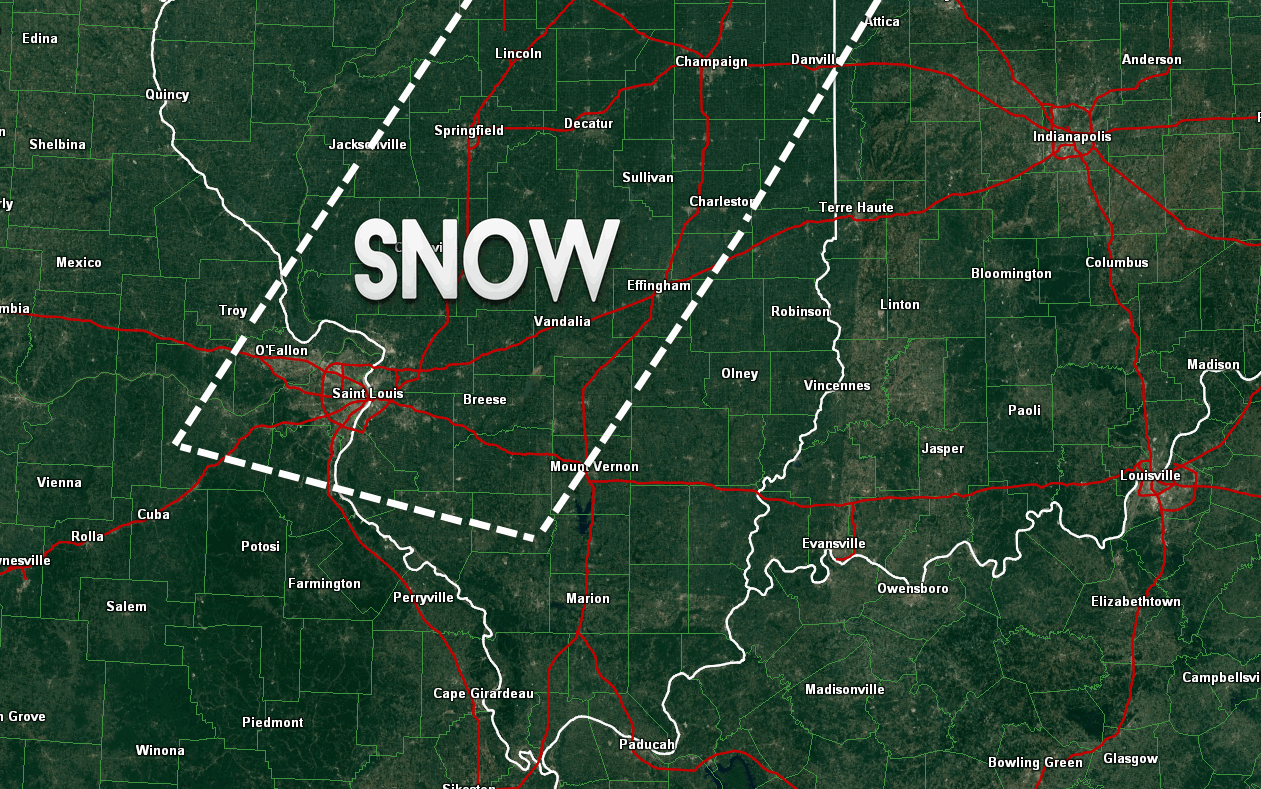
Here is the area I have marked for some snow today. This is where some accumulation will be possible. Not saying there won’t be some snowflakes in the air elsewhere – just that this area is where some snow may stick.
Areas in the white box may pick up a dusting or a slushy inch or two of snow. The system is weaker and further east than anticipated.
I am monitoring a series of storm systems as we push into the weekend and next week. We may have to deal with some wintry weather.
Our first real blast of cold air of the month arrives next week into the following week.

Updated everything at 10 am to account for the system being further east and weaker than anticipated.

Rain could change to snow today across portions of eastern Missouri into parts of southern Illinois.

The wild card tells you where the most uncertainty is in the current forecast.
Wild card in this forecast – the wild card in the forecast remains the same. Who will see some snowflakes in the air today into this evening as temperatures fall into the 30’s.

Will I need to take action?
Umbrella’s again today. Scattered showers from time to time. There could be some snow at some point as colder air filters into the region. Best chances to see snow would be over eastern Missouri and parts of southern Illinois. Not expecting any significant accumulations in our local area.

How much rain should this system produce over our region?
An additional 0.20″-0.40″ of precipitation is possible today.

Some snow chances today as the colder air moves into the region. Best chances would be over parts of eastern Missouri and parts of southern Illinois.
This does not look to be a big deal for the counties I forecast for.

Another rain maker should approach the region by the weekend.
I am monitoring a couple of storm systems for next week. Much colder air also arrives next week. We may have to deal with some winter precipitation next week. Stay tuned.

We have regional radars and local city radars – if a radar does not seem to be updating then try another one. Occasional browsers need their cache cleared. You may also try restarting your browser. That usually fixes the problem. Occasionally we do have a radar go down. That is why I have duplicates. Thus, if one fails then try another one.
If you have any problems then please send me an email beaudodson@usawx.com
WEATHER RADAR PAGE – Click here —
We also have a new national interactive radar – you can view that radar by clicking here.
Local interactive city radars include St Louis, Mt Vernon, Evansville, Poplar Bluff, Cape Girardeau, Marion, Paducah, Hopkinsville, Memphis, Nashville, Dyersburg, and all of eastern Kentucky – these are interactive radars. Local city radars – click here
NOTE: Occasionally you will see ground clutter on the radar (these are false echoes). Normally they show up close to the radar sites – including Paducah.

Regional Radar – Click on radar to take you our full radar page.


Regional Radar

Current WARNINGS (a warning means take action now). Click on your county to drill down to the latest warning information. Keep in mind that there can be a 2-3 minute delay in the updated warning information.
I strongly encourage you to use a NOAA Weather Radio or warning cell phone app for the most up to date warning information. Nothing is faster than a NOAA weather radio.


Color shaded counties are under some type of watch, warning, advisory, or special weather statement. Click your county to view the latest information.

Missouri Warnings

Illinois Warnings

Kentucky Warnings

Please visit your local National Weather Service Office by clicking here. The National Weather Service Office, for our region, is located in Paducah, Kentucky.

Here is the official 6-10 day and 8-14 day temperature and precipitation outlook. Check the date stamp at the top of each image (so you understand the time frame).
The forecast maps below are issued by the Weather Prediction Center (NOAA).


The latest 8-14 day temperature and precipitation outlook. Note the dates are at the top of the image. These maps DO NOT tell you how high or low temperatures or precipitation will be. They simply give you the probability as to whether temperatures or precipitation will be above or below normal.


Many of my graphics are from www.weatherbell.com – a great resource for weather data, model data, and more


This blog was inspired by ABC 33/40’s Alabama Weather Blog – view their blog
Current tower cam view from the Weather Observatory- Click here for all cameras.

Southern Illinois Weather Observatory

The Weather Observatory

Southern Illinois Weather Observatory
WSIL TV 3 has a number of tower cameras. Click here for their tower camera page & Illinois Road Conditions

Marion, Illinois
WPSD TV 6 has a number of tower cameras. Click here for their tower camera page & Kentucky Road Conditions & Kentucky Highway and Interstate Cameras

Downtown Paducah, Kentucky
Benton, Kentucky Tower Camera – Click here for full view

Benton, Kentucky

I24 Paducah, Kentucky

I24 Mile Point 9 – Paducah, KY

I24 – Mile Point 3 Paducah, Kentucky

You can sign up for my AWARE email by clicking here I typically send out AWARE emails before severe weather, winter storms, or other active weather situations. I do not email watches or warnings. The emails are a basic “heads up” concerning incoming weather conditions.