We have some great sponsors for the Weather Talk Blog. Please let our sponsors know that you appreciate their support for the Weather Talk Blog.
Milner and Orr Funeral Home and Cremation Services located in Paducah, Kentucky and three other western Kentucky towns – at Milner and Orr they believe in families helping families. You can find Milner and Orr on Facebook, as well.
![]()
.

Wortham Dental Care located in Paducah, Kentucky. The gentle dentist. Mercury free dentistry. They also do safe Mercury removal. You can find Wortham Dental Care on Facebook, as well
.

For all of your families eye care needs. Visit their web-site here. Or, you can also visit their Facebook page.
.

Endrizzi’s Storm Shelters – For more information click here. Endrizzi Contracting and Landscaping can be found on Facebook, as well – click here
.

Best at Enabling Body Shop Profitability since 1996. Located In Paducah Kentucky and Evansville Indiana; serving all customers in between. They provide Customer Service, along with all the tools necessary for body shops to remain educated and competitive. Click the logo above for their main web-site. You can find McClintock Preferred Finishes on Facebook, as well
.

Duck/goose decoys? Game calls? Optics? We have you covered! Click the logo above or visit Final Flight on Facebook, as well.
.
.
I have launched the new weather texting service! I could use your help. Be sure and sign up and fully support all of the weather data you see each day.
This would make a great Christmas present for someone 🙂
This is a monthly subscription service. Supporting this helps support everything else. The cost is $3 a month for one phone, $5 a month for three phones, and $10 a month for seven phones.
For more information visit BeauDodsonWeather.com
Or directly sign up at Weathertalk.com


This forecast update covers far southern Illinois, far southeast Missouri, and far western Kentucky. See the coverage map on the right side of the blog.
Remember that weather evolves. Check back frequently for updates, especially during active weather.
Updated to add more wording for thunderstorms.
Monday night – Mostly cloudy. Patchy fog possible. Cooler. A chance for a few showers and thunderstorms.
Temperatures: Lows in the upper 30s to lower 40s over southeast Missouri and southern Illinois. Lows in the 42-48 degree range for western Kentucky and northwest Tennessee.
Winds: Winds becoming north and northeast at 4-8 mph
What is the chance for precipitation? 40%-60%
Coverage of precipitation? Scattered
My confidence in this part of the forecast verifying is High
Should I be concerned about snow or ice? No
Should I cancel my outdoor plans? No
Is severe weather expected? No
What impact is expected? Wet roadways. Lightning.
Tuesday – Patchy morning fog possible. A mix of sun and clouds. Small chance for a few showers (maybe rumble of thunder) before 9 am. Mild.
Temperatures: Highs in the 54 to 58 degree range. Some data pops a few 60 degree readings in the area.
Winds: North winds becoming east/southeast winds. 6-12 mph. Winds could be variable at times.
What is the chance for precipitation? 30% before 9 am and mainly over our eastern counties. That would be the Pennyrile area of western Kentucky.
Coverage of precipitation? Isolated.
My confidence in this part of the forecast verifying is High
Should I be concerned about snow or ice? No
Should I cancel my outdoor plans? No
Is severe weather expected? No
What impact is expected? Possibly wet roadways. Small chance for lightning.
Tuesday night – Cloudy. A chance for some showers early and then showers and thunderstorms likely after midnight. Temperatures rising all night.
Temperatures: Lows in the 50-55 degree range. Temps will rise all night and some places could be in the upper 50s to lower 60s by Wednesday morning.
Winds: East/southeast at 10 mph. Winds becoming southerly and increasing to 8-16 mph towards morning.
What is the chance for precipitation? 20% early and then 60% late
Coverage of precipitation? Scattered to perhaps widespread late at night into the morning hours
My confidence in this part of the forecast verifying is Medium
Should I be concerned about snow or ice? No
Should I cancel my outdoor plans? Evening hours should be dry. Better chances for rain after midnight.
Is severe weather expected? Monitor updates. Not likely.
What impact is expected? Wet roadways. Lightning.
Wednesday – Mostly cloudy. Showers and thunderstorms likely. A few storms could be heavy. Gusty winds.
Temperatures: Highs from 64 to 68 degrees
Winds: South/southeast at 8-16 mph. Gusts over 25 mph likely.
What is the chance for precipitation? 90%
Coverage of precipitation? Widespread.
My confidence in this part of the forecast verifying is High
Should I be concerned about snow or ice? No
Should I cancel my outdoor plans? Have a plan B in mind.
Is severe weather expected? Yes. Some severe weather may occur on Wednesday. Damaging winds and isolated tornado threat being the main concern.
What impact is expected? Wet roadways. Lightning possible. Gusty winds. A risk for severe thunderstorms, as well.
Wednesday night – Cloudy. Showers possible. But, ending late. Thunderstorms possible early. Things should be winding down early in the evening.
Temperatures: Lows should drop into the upper 30s and lower 40s over southeast Missouri and southern Illinois and mostly in the 40s over western Kentucky and northwest Tennessee.
Winds: Southwest becoming west/northwest winds at 10-20 mph. Gusty winds likely early in the night.
What is the chance for precipitation? 40%-60% early and then diminishing to 20% after midnight.
Coverage of precipitation? Widespread early and then becoming isolated late.
My confidence in this part of the forecast verifying is High
Should I be concerned about snow or ice? No
Should I cancel my outdoor plans? No, but have a plan B in mind early in the evening. Some showers may remain.
Is severe weather expected? Yes. There will be a risk for a few severe thunderstorms early Wednesday evening.
What impact is expected? Wet roads. Lightning possible. Gusty winds. A chance for a few severe storms early in the evening.
Thursday – Mix of sun and clouds. Perhaps a little cooler. Should be a dry day.
Temperatures: Highs from 52-58
Winds: Northeast and east winds becoming southeast during the afternoon at 4-8 mph.
What is the chance for precipitation? 10%
Coverage of precipitation? None
My confidence in this part of the forecast verifying is High
Should I be concerned about snow or ice? No
Should I cancel my outdoor plans? No
Is severe weather expected? No
What impact is expected? None
Thursday night – Patchy clouds. A small chance for a shower.
Temperatures: Lows from 38-44 over southeast Missouri and southern Illinois and lower to middle 40s elsewhere.
Winds: East winds at 4-8 mph.
What is the chance for precipitation? 20%
Coverage of precipitation? Isolated
My confidence in this part of the forecast verifying is Medium
Should I be concerned about snow or ice? No
Should I cancel my outdoor plans? No
Is severe weather expected? No
What impact is expected? None (unless wet roadways after midnight)
Low confidence on the Christmas Day forecast into Saturday. Models are producing wild swings in the track of a new low coming out of the southwest at some point this coming weekend. This is where knowledge ends and speculation begins.
The probability for rain may change substantially as more data becomes available. I broad-brushed them at 40%. Very heavy rain is possible somewhere in the region over the weekend into early next week. But, placement is uncertain. Models are producing wild swings from run to run. Let’s keep an eye on it.
Friday – Clouds. Mild. A chance for a few showers. Maybe a rumble of thunder. Low confidence on Friday’s forecast.
Temperatures: Highs in the upper 50s to lower 60s
Winds: East and southeast winds at 8-16 mph. Perhaps gusty at times.
What is the chance for precipitation? 40% (but low confidence and this number could change)
Coverage of precipitation? Scattered. But this could change to widespread as we draw closer. Timing of the Friday-Saturday system is questionable. It is possible Friday ends up mostly dry.
My confidence in this part of the forecast verifying is LOW
Should I be concerned about snow or ice? No
Should I cancel my outdoor plans? There could be precipitation on Christmas Day
Is severe weather expected? Monitor updates.
What impact is expected? Perhaps wet roads. The rain may hold off till Friday night. Low confidence. Thunder possible.
Friday night – A chance for showers and possibly thunderstorms.
Temperatures: Lows in the 50s
Winds: South winds at 10-15 mph
What is the chance for precipitation? 40%
Coverage of precipitation? Scattered
My confidence in this part of the forecast verifying is LOW
Should I be concerned about snow or ice? No
Should I cancel my outdoor plans? Rain possible.
Is severe weather expected? Monitor updates
What impact is expected? Wet roadways
Saturday – A chance for showers and thunderstorms.
Temperatures: Highs in the 60s.
Winds: South winds at 10-15 mph.
What is the chance for precipitation? 40%
Coverage of precipitation? Scattered
My confidence in this part of the forecast verifying is LOW
Should I be concerned about snow or ice? No
Should I cancel my outdoor plans? Have a plan B and monitor updates. Low confidence.
Is severe weather expected? Monitor updates.
What impact is expected? Wet roadways. Lightning.
Saturday night – A chance for showers and possibly thunderstorms.
Temperatures: Lows in the 50s
Winds: South winds at 10-15 mph
What is the chance for precipitation? 40%
Coverage of precipitation? Scattered
My confidence in this part of the forecast verifying is LOW
Should I be concerned about snow or ice? No
Should I cancel my outdoor plans? Rain possible.
Is severe weather expected? Monitor updates
What impact is expected? Wet roadways
Sunday – A chance for showers and thunderstorms.
Temperatures: Highs in the 60s.
Winds: South winds at 10-15 mph.
What is the chance for precipitation? 40%
Coverage of precipitation? Scattered
My confidence in this part of the forecast verifying is LOW
Should I be concerned about snow or ice? No
Should I cancel my outdoor plans? Have a plan B and monitor updates. Low confidence.
Is severe weather expected? Monitor updates.
What impact is expected? Wet roadways. Lightning.
Click their ad below to visit their web-site or click here reedelec.com


Don’t forget to check out the Southern Illinois Weather Observatory web-site for weather maps, tower cams, scanner feeds, radars, and much more! Click here

An explanation of what is happening in the atmosphere over the coming days…
Highlights
1. Let’s pay attention this week to the weather
2. Strong to severe storms possible on Wednesday
3. A heavy rain event somewhere in the Missouri to Ohio/Tennessee River Valleys this coming weekend into early next week
We have a lot of weather to cover.
I want everyone to pay attention to changing weather conditions over the coming days. I do have some concerns.
A few showers will remain in the region on Monday night into Tuesday morning. However, they should be more scattered than anything. A few thunderstorms also possible. Most of Tuesday should remain dry. There is a small risk for lightning tonight and early Tuesday morning. Again, believe most areas will remain dry.
A strange weather event will occur on Tuesday night and Wednesday. Low temperatures on Tuesday night will actually occur early in the evening. Then, temperatures will rise into the 60s by Wednesday morning. Temperatures should be 30 degrees above normal by Wednesday morning. And, this can’t be good news.
Dew points will also be on the rise. This will be in response to a deep area of low pressure developing just to our west and northwest. This low will track northeast on Wednesday. Since the low spins counter-clockwise that means that Gulf of Mexico air will be pulled northward into our region. This rich moisture will help produce widespread showers and thunderstorms. Some of those storms could be intense.
Instability will be sufficient on Wednesday for the potential of a few severe thunderstorms. The main concern will be damaging winds and tornadoes. The overall risk for severe weather is questionable. I suggest everyone monitor the latest forecast updates. There appears to be an enhanced risk area over Kentucky and Tennessee. That is not to say that Missouri and Illinois are out of the woods. Again, monitor updates.
Right now it appears that Thursday will remain dry. Especially after 9 am. There could still be some thunderstorms Wednesday night. But, as the night wears on, the activity should push off to the east/northeast.
Big question marks arise on the forecast for Friday. Sigh. The model guidance delivers anything but confidence. The EC model ensembles show a good chance for showers and thunderstorms. The operational GFS model guidance shows that it will remain dry. The GFS ensembles indicate rain. My confidence on the Christmas Day forecast is as low as it can be.
Confidence in the forecast rises a bit Friday night into next Tuesday. A heavy rain event is developing for parts of the Missouri and Ohio Valleys. Data indicates rainfall totals could exceed 4″ in a band somewhere in the above mentioned region. The exact placement won’t be known for several more days. Flash flood and/or flood watches may need to be issued for portions of the region Saturday into early next week. Again, let’s monitor updated forecasts.
There are a lot of moving parts to the upcoming 7-10 day forecast period. And, that means the possibility of forecast changes.
Let me show you some graphics to go along with the comments above.
This first map is for late Monday night. You can see some grey colors over our region. That represents a few light showers. But, precipitation should be moving eastward with time. Suspect rainfall totals, if they occur, will be low between 9 pm Monday night and 7 am Tuesday morning. And, perhaps mainly over our eastern counties.
Click images for larger views. Images are from weatherbell.com

This next map is for Tuesday late morning. Just a couple of patches of light precipitation showing up over western Tennessee. Let’s keep the chances around 20% on Tuesday morning. But, most areas should remain dry.

This next map is for 11 pm on Tuesday night. Some showers redeveloping as southerly winds pick back up. Moisture will be pulled northward with time as an area of low pressure develops to our west.

By Wednesday morning I am expecting scattered showers and possibly thunderstorms over our region.

Here, at 11 am on Wednesday morning, you can see one area of low pressure over Iowa (the closed circle). Numerous showers and thunderstorms in our region.

We move forward to Wednesday at 6 pm. Numerous showers and thunderstorms in our region. Some of these storms could be quite strong and/or severe. Monitor updates.

Moving ahead to 9 pm on Wednesday night. This is the three hour precipitation totals from 6 pm to 9 pm. You can see still some coverage in our area. However, precipitation should be on the exit by Wednesday evening into the night. By Thursday morning there will only be small rain chances remaining. And, mostly before 7 am.

Let me show you CAPE numbers for this event. What are CAPE values and what do they mean in relation to severe weather? I found a great post about CAPE values and this should explain it. For you go-getter weather enthusiasts – click here
Sufficient numbers for some concern. It does not take much CAPE during the winter months to cause problems. Typically you see higher numbers in the spring and fall. The reason it doesn’t take much in the winter is because the wind fields aloft are typically stronger. This makes up the difference in low CAPE numbers.
This first map is for Wednesday at 11 am. All of the blue represents CAPE. Some of the numbers in our region will reach 700-1000 on Wednesday. BUFKIT indicates some 900+ readings for western Kentucky. Again, sufficient for some concern.

Moving ahead to 2 pm to 3 pm. Again, plenty of CAPE in our region for thunderstorms.

Moving ahead to Wednesday evening. The NAM model continues to show CAPE in our region. Some storms will be possible into Wednesday evening. Long day for the weatherman.

Look at these morning temperatures for Wednesday. Truly this is amazing. Normal lows for this time of the year are around 30 degrees. We will be 30 degrees above normal.
Click images for larger views.

Wednesday evening temperatures. Note the cold air in North Dakota. You have to travel quite some distance to find truly colder air. Temperatures on Wednesday evening should be in the upper 30s over northwest Missouri. Quite a range of temperatures. You can see 60s for the Missouri Bootheel. This is one more reason for the thunderstorms. Strong cold front draped across the Missouri Valley.

This next map is stunning. This is the temperature anomaly map for Wednesday morning. Yes, those are 30+ degrees above normal showing up in the charts. What a crazy month this has been. I don’t ever recall such sustained warmth during the Month of December.

This next map shows you the 850 mb wind fields. These are winds about 5000′ aloft. This is a good indicator for severe weather. The stronger these winds the better odds of strong storms. I circled our region. Winds at the 850 mb level should exceed 50 knots. This map is from wright-weather.com

This next map is the 500 mb level. Thousands of feet aloft. Look at the dip in the jet stream. Trough. Strong winds aloft over our region. Yet one more ingredient for some strong storms.

Here is the GFS model guidance for Wednesday. It also shows quite a bit of CAPE in the region.

Now, let’s more ahead.
VERY low confidence on the forecast for Friday into next Tuesday. I just don’t know where the heaviest rain will set up. This will need to be monitored. There will certainly be changes in the forecast.
This is the GFS model guidance. One common theme in the guidance is that there will be a heavy band of rain somewhere in the Missouri and Ohio Valleys. Perhaps Tennessee Valley, as well.
This first chart is for Saturday morning. You can see a lot of precipitation in our region. Snow well to the north in the blue colors. Images below will be from weatherbell.com

Moving ahead to Saturday late morning. Rain continues according to this model. The pink and orange colors represent freezing rain and sleet. Blue and purple are snow. Green would be rain.

Moving ahead to Saturday night around 11 pm. Rain, some heavy rain, continues in the region. Note the snow back over northern Missouri, Kansas, and Oklahoma.

Moving ahead to Sunday morning. Rain, some heavy, continues in the region. Anyone with travel plans Friday into Tuesday should monitor updates.

Moving ahead to 11 pm Sunday night. Yes, rain continues. The pink and orange colors represent freezing rain and sleet. Blue and purple are snow. Green would be rain.

Moving ahead to Monday morning. Rain, some heavy, continues in the region. Again, low confidence on the placement of the heaviest rain totals.

Let me show you some rainfall maps
These two images show you rainfall totals for this next event. This is the same model. Each map is of a different time for the model to produce data. The GFS produces maps four times each day. What a meteorologist would like to see is some agreement from one run to the next run. The more agreement over time the more confidence one will give the forecast.
There is a good agreement among the data that someone ends up with a lot of rain. There is little agreement on placement. Thus, I encourage you to monitor updates.

Then six hours later the model shifts the band northward.
The models have been shifting this around for several days now. Each run shows something a little bit different.
What is important is the idea that there could be some heavy rain in the region this coming weekend into early next week. Details will be worked out over time.

Let’s pay attention over the coming 7-10 days.

No snow anticipated.

Tuesday – No snow or ice anticipated.
Wednesday – No snow or ice anticipated.
Thursday – No snow or ice anticipated.
Friday – No snow or ice anticipated.
Saturday – No snow or ice anticipated.

I continue to update temperatures and winds. No major shifts this time. But, small ones.
I continue to monitor precipitation probabilities through the weekend. Very low confidence on the Friday through Sunday forecast. Changes are likely to occur.

Gusty winds on Wednesday.
Severe thunderstorms are possible on Wednesday. Let’s keep an eye on it.
Heavy rain potential Friday (questionable) through next Monday (higher chances SAT-MON). Flooding possible.

A few thunderstorms are possible Tuesday night.
Severe thunderstorms are possible on Wednesday. Monitor updates.
Gusty winds likely on Wednesday.
Monitoring heavy rain potential this coming weekend into early next week.

The wild card in this forecast will be the risk for some strong or severe storms on Wednesday. Instability combined with strong wind fields suggest at least the potential for some severe weather in or near our region. Let’s keep an eye on this.

How much precipitation should we expect over the next few days?
A lot to monitor over the coming days. Widespread rain and some storms will arrive on Tuesday night into Wednesday night. Rainfall totals of 0.40″-0.80″ will be possible. Local amounts will exceed 1″.
Here is the rainfall map through Thursday morning

This next map is the rainfall map through next Monday. This map is subject to changes. Monitor updates.


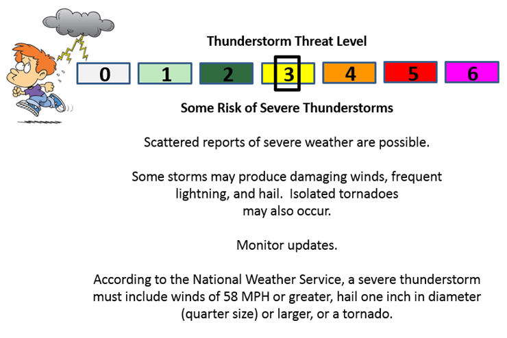
Can we expect severe thunderstorms over the next 24 to 48 hours? Remember that a severe thunderstorm is defined as a thunderstorm that produces 58 mph winds or higher, quarter size hail or larger, and/or a tornado.
The thunderstorm threat level will be a ONE for Tuesday morning and a TWO Tuesday night. Wednesday will be a THREE.
.
Monday Night – Thunderstorms are possible. Not severe. Lightning is the main concern.
Tuesday – Severe weather is not anticipated. Thunder possible early in the morning.
Tuesday Night – Monitor updates. Some potential for storms as early as Tuesday night.
Wednesday – Some severe weather can’t be ruled out. Monitor updates.
Thursday – Severe weather is not anticipated
Friday – Severe weather is not anticipated.
Saturday – Monitor updates.
Sunday – Monitor updates.

and then for Wednesday

We have regional radars and local city radars – if a radar does not seem to be updating then try another one. Occasional browsers need their cache cleared. You may also try restarting your browser. That usually fixes the problem. Occasionally we do have a radar go down. That is why I have duplicates. Thus, if one fails then try another one.
If you have any problems then please send me an email beaudodson@usawx.com
WEATHER RADAR PAGE – Click here —
We also have a new national interactive radar – you can view that radar by clicking here.
Local interactive city radars include St Louis, Mt Vernon, Evansville, Poplar Bluff, Cape Girardeau, Marion, Paducah, Hopkinsville, Memphis, Nashville, Dyersburg, and all of eastern Kentucky – these are interactive radars. Local city radars – click here
NOTE: Occasionally you will see ground clutter on the radar (these are false echoes). Normally they show up close to the radar sites – including Paducah.


Here is the official 6-10 day and 8-14 day temperature and precipitation outlook. Check the date stamp at the top of each image (so you understand the time frame).
The forecast maps below are issued by the Weather Prediction Center (NOAA).


The latest 8-14 day temperature and precipitation outlook. Note the dates are at the top of the image. These maps DO NOT tell you how high or low temperatures or precipitation will be. They simply give you the probability as to whether temperatures or precipitation will be above or below normal.


Here are the current river stage forecasts. You can click your state and then the dot for your location. It will bring up the full forecast and hydrograph.
Click Here For River Stage Forecasts…

Who do you trust for your weather information and who holds them accountable?
I have studied weather in our region since the late 1970’s. I have 37 years of experience in observing our regions weather patterns. My degree is in Broadcast Meteorology from Mississippi State University and an Associate of Science (AS). I am currently working on my Bachelor’s Degree in Geoscience.
My resume includes:
Member of the American Meteorological Society.
NOAA Weather-Ready Nation Ambassador.
Meteorologist for McCracken County Emergency Management. I served from 2005 through 2015.
I own and operate the Southern Illinois Weather Observatory.
Recipient of the Mark Trail Award, WPSD Six Who Make A Difference Award, Kentucky Colonel, and the Caesar J. Fiamma” Award from the American Red Cross.
In 2009 I was presented with the Kentucky Office of Highway Safety Award.
Recognized by the Kentucky House of Representatives for my service to the State of Kentucky leading up to several winter storms and severe weather outbreaks.
I am also President of the Shadow Angel Foundation which serves portions of western Kentucky and southern Illinois.
There is a lot of noise on the internet. A lot of weather maps are posted without explanation. Over time you should learn who to trust for your weather information.
My forecast philosophy is simple and straight forward.
- Communicate in simple terms
- To be as accurate as possible within a reasonable time frame before an event
- Interact with you on Twitter, Facebook, and the blog
- Minimize the “hype” that you might see on television or through other weather sources
- Push you towards utilizing wall-to-wall LOCAL TV coverage during severe weather events
I am a recipient of the Mark Trail Award, WPSD Six Who Make A Difference Award, Kentucky Colonel, and the Caesar J. Fiamma” Award from the American Red Cross. In 2009 I was presented with the Kentucky Office of Highway Safety Award. I was recognized by the Kentucky House of Representatives for my service to the State of Kentucky leading up to several winter storms and severe weather outbreaks.
If you click on the image below you can read the Kentucky House of Representatives Resolution.

Many of my graphics are from www.weatherbell.com – a great resource for weather data, model data, and more


You can sign up for my AWARE email by clicking here I typically send out AWARE emails before severe weather, winter storms, or other active weather situations. I do not email watches or warnings. The emails are a basic “heads up” concerning incoming weather conditions.