We have our first sponsor for the blog. Milner and Orr Funeral Home and Cremation Services located in Paducah, Kentucky and three other western Kentucky towns – at Milner and Orr they believe in families helping families.
![]()

This forecast update covers far southern Illinois, far southeast Missouri, and far western Kentucky. See the coverage map on the right side of the blog.
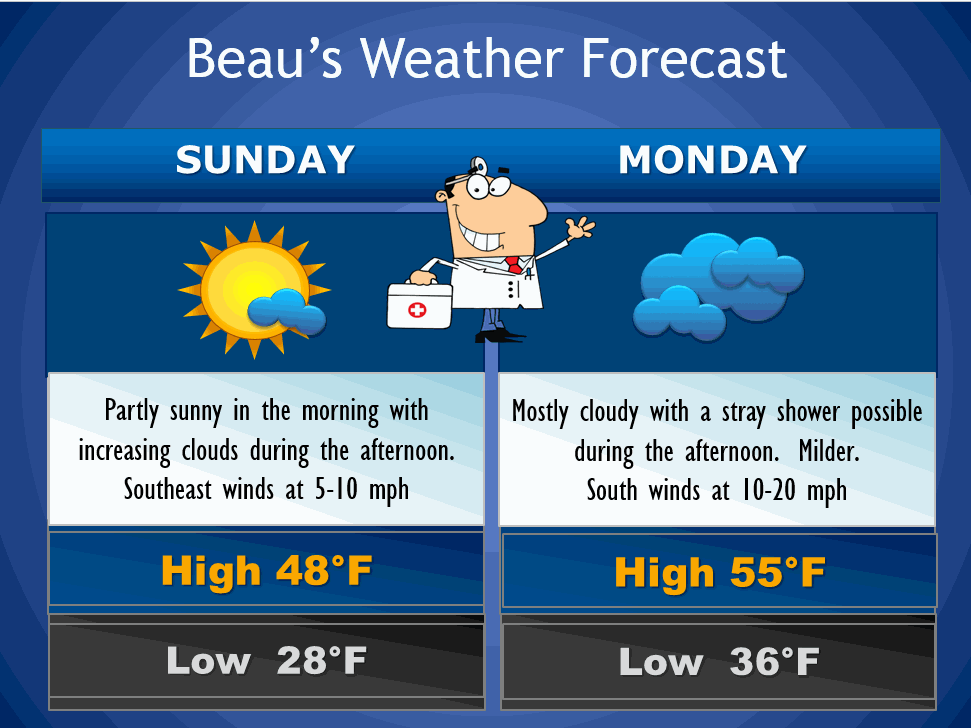
Sunday – A mix of sun and clouds – It will be a bit milder. High temperatures from 45-50 degrees. Southeast winds at 10 mph.
Sunday night – Mostly cloudy. Low temperatures in the 32-36 degree range – temperatures may rise a bit towards morning. Southeast winds at 10 mph.
Monday – We will see quite a few clouds. A shower possible. We will also have some gusty winds from time to time . High temperatures in the 48 to 55 degree range. Winds will be from the south/southeast at 10-20 mph with higher gusts at times.
Monday night – Mostly cloudy. A period or two of rain likely. A rumble of thunder is possible. Low temperatures in the 40’s – temperatures will rise a bit towards morning. Southeast winds at 10-15 mph.
Tuesday – Milder. Cloudy with a chance of rain. A thunderstorm is possible. High temperatures will be in the 50’s. South to southwest winds at 10-15 mph.
Tuesday night – Very low confidence in this part of the forecast – changes are likely. Cloudy with rain likely. Turning colder with low temperatures in the 30’s. Northwest winds at 10-20 mph. If temperatures fall enough and the low tracks a bit to our east then the rain may mix with snow after midnight.
Christmas Eve – Mostly cloudy and colder. Gusty winds. A few snow showers or flurries possible. Lows on Wednesday morning will be in the 30’s with afternoon highs only in the 30’s.
Christmas Day – Partly sunny. Breezy winds at 10-15 mph. Highs in the 40’s.
Current Temperatures Around The Local Area


An explanation of what is happening in the atmosphere over the coming days.
Quite a bit to monitor over the coming 7-10 days.
1. Calm weekend
2. Rain showers by Monday/Tuesday – perhaps even a thunderstorm on Tuesday
3. Rain may change to snow on Tuesday night (very low confidence in this part of the forecast)
4. Falling temperatures Tuesday night
5. Snow showers possible Wednesday
6. Windy conditions Tuesday through Thursday
7. Next system arrives around Friday/Saturday – looks to be a warm system with rain and perhaps even thunderstorms (lot of uncertainty on that system and the track of the area of low pressure)
Your friendly weatherman is under the weather. Caught a cold. Now that is not a very nice gift to receive right before I am supposed to fly home on Tuesday. Let’s hope it passes quickly. Can’t fly with a head cold. Been there and done that – ended up with a hearing problem for a year! This happened a few years ago. I won’t repeat that mistake.
Anyway – you did not come here for my medical update.
I could include it in this graphic?
🙂 Okay enough with that!
Today won’t be too bad. Hopefully we will have more sun than clouds. The sun did show up on Saturday for awhile. Santa came early for some of you. I know you wished for sunshine. Let’s hope we have more today.
We have a couple of weather makers to track for the new work week.
The first one arrives on Monday into Tuesday. A cold front will approach the area on Tuesday morning – this will spread rain showers back into the area. There will be a few showers on Monday. Rain showers will increase on Monday night and Tuesday.
There may be a lull in the precipitation at some point as a new storm system takes shape to our south and southwest. This system should move into the Tennessee and Ohio Valley – Missouri Valley late on Tuesday into Tuesday night. This will spread more rain back into the area. Some moderate rain is possible.
I have very little confidence in how Tuesday night and Wednesday morning unfolds. The data is all over the place on the evolution of a secondary low during this time frame. I suspect the forecast could change more than once. So, with that in mind just know that a changeable forecast is possible on Tuesday night and Wednesday morning.
The big question is going to be where does the area of low pressure track. Another question is the strength of the low.
Let’s assume the low does form. What would that mean?
If it tracks to our west then we are looking at mostly a rain event. If it tracks a bit to our east and south then the colder air would arrive soon. That would mean some light snow at the end of the storm system.
Monitor updates if you have travel plans to our north and northwest on Tuesday into Wednesday. I can’t rule out some frozen precipitation if the colder air arrives sooner. This would be most likely over parts of western and central Missouri into central and northern Illinois.
If the storm does take a more eastern track then that snow line would shift a bit further east.
Snow showers or flurries are possible in our area on Wednesday. Christmas day now appears that it will be partly sunny and dry.
We will see how it goes.
Colder air is likely the last week of December and the first week of January. Whether we can pick up a storm in that cold air will need to be determined. Our snow luck has not been great over the last few weeks.

Adjusted temperatures for Monday and Tuesday. Some question on the timing of the colder air on Tuesday night and Wednesday morning.
Also some question on rainfall totals. If the low tracks near our region then we could see some locally moderate totals. Some of the data is pushing 1″ amounts by Wednesday morning.
This is assuming that second low even forms. Also the strength of the area of low pressure will be in question.

No worries through Monday afternoon.

The Wild Card gives you an idea of what might change that would cause the forecast to bust. A busted forecast means a forecast that does not verify.
Wild card in this forecast – no significant wild cards for the next 24 hours.

Will I need to take action?
No

Please visit your local National Weather Service Office by clicking here. The National Weather Service Office, for our region, is located in Paducah, Kentucky.

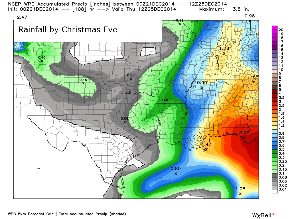
How much rain should this system produce over our region?
Rainfall totals through Wednesday morning – scale is at the right side of the image.
These rainfall totals are dependent on the second low pressure center forming over the TN Valley and moving northeastward into our region.

No winter storms through Tuesday afternoon. Sorry snow fans! Boy, it has been hard to come by snow during the past month.
Tuesday will bring rain showers, but falling temperatures by Tuesday night could change the rain showers to snow showers. I will be monitoring the latest data as this area of low pressure pushes through the area.

It appears we may finally see some sharply colder temperatures as we push into the last part of December and the first week of January. Not sure we can pull a storm into that cold air. But, at least it does look cold (I say at least for those who like the cold and snow. I know some of you would just as soon not have the cold and snow)
Many of my graphics are from www.weatherbell.com – a great resource for weather data, model data, and more


This blog was inspired by ABC 33/40’s Alabama Weather Blog – view their blog
Current tower cam view from the Weather Observatory- Click here for all cameras.

Southern Illinois Weather Observatory

The Weather Observatory

Southern Illinois Weather Observatory
WSIL TV 3 has a number of tower cameras. Click here for their tower camera page & Illinois Road Conditions

Marion, Illinois
WPSD TV 6 has a number of tower cameras. Click here for their tower camera page & Kentucky Road Conditions & Kentucky Highway and Interstate Cameras

Downtown Paducah, Kentucky
Benton, Kentucky Tower Camera – Click here for full view

Benton, Kentucky

I24 Paducah, Kentucky

I24 Mile Point 9 – Paducah, KY

I24 – Mile Point 3 Paducah, Kentucky