
We have our first sponsor for the blog. Milner and Orr Funeral Home and Cremation Services located in Paducah, Kentucky and three other western Kentucky towns – at Milner and Orr they believe in families helping families.
![]()

This forecast update covers far southern Illinois, far southeast Missouri, and far western Kentucky. See the coverage map on the right side of the blog.
Saturday – Appears we will see quite a few clouds during the morning hours with increasing chances for sunshine during the afternoon. We will see how this goes. It has been tricky getting rid of clouds over the last few weeks. High temperatures in the 40’s. Northeast winds at 5-10 mph.
Saturday night – Just a few clouds, otherwise stars. Chilly. Low temperatures in the upper 20’s. East winds at 5-10 mph.
Sunday – A mix of sun and clouds – possibly more clouds in the afternoon compared to the morning hours. It will be a bit milder. High temperatures from 45-50 degrees. Southeast winds at 10-15 mph.
Sunday night – Mostly cloudy. Low temperatures in the 30’s – temperatures may rise a bit towards morning. Southeast winds at 10-15 mph.
Monday – We will see quite a few clouds. A shower possible. We will also have some gusty winds from time to time . It will be on the cool side with high temperatures in the lower to middle 50’s. Winds will be from the southeast at 10-20 mph with higher gusts at times.
Tuesday will bring mild air ahead of the storm system and then rapidly falling temperatures as the area of low pressure pulls away to our east. Rain showers (rumble of thunder) on Tuesday might give way to some snow showers on Tuesday night. We will see how much precipitation is left over the region as temperatures fall.
Christmas Eve and Christmas Day – Mostly cloudy and colder. Gusty winds. A few snow showers or flurries possible. Lows on Christmas Eve morning will be in the 30’s and highs on Christmas Eve will be in the 30’s. Christmas Day will bring morning temperatures in the 20’s with afternoon highs in the 30’s.
Current Temperatures Around The Local Area


An explanation of what is happening in the atmosphere over the coming days.
Plenty to monitor over the coming 7-10 days.
1. Calm weekend
2. Rain showers by Monday/Tuesday
3. Rain may change to snow on Tuesday night
4. Rapidly falling temperatures Tuesday night
5. Snow showers possible Wednesday and Thursday
6. Windy conditions Tuesday through Thursday
7. Next system arrives around Friday
We have a calm weekend in store for you! The last weekend before Christmas. Aren’t you glad it will be calm?
Some light snow flurries and snow showers fell overnight. Some places had a hint of a dusting on cars and grassy areas. I know it wasn’t much, but at least the forecast had snow showers in it!
It will be a bit on the chilly side today, but a gradual warming trend will be underway as we push into Sunday. This is in response to our next storm system for the beginning of the new work week.
Rain showers arrive by Monday and Tuesday – milder. We may even see a rumble of thunder on Tuesday.
All of the latest data is trending the area of low pressure to our east on Tuesday/Tuesday night further west. This could make the weather a bit more interesting as we push into Tuesday night. Falling temperatures by Tuesday night with perhaps some snow showers.
The extent of the snow showers on Tuesday night will depend on the track of that area of low pressure.
The biggest question for today and Sunday will be cloud cover. Let me show you some cloud cover charts. The white area represents clouds and the black area represents sunny areas. You can see the clouds and sun are going to flirt through the weekend. Hopefully the sun will win out.
Let’s be honest 🙂 – you know the weather is slow when I am showing you potential cloud cover maps.
White = clouds
Black = sunshine
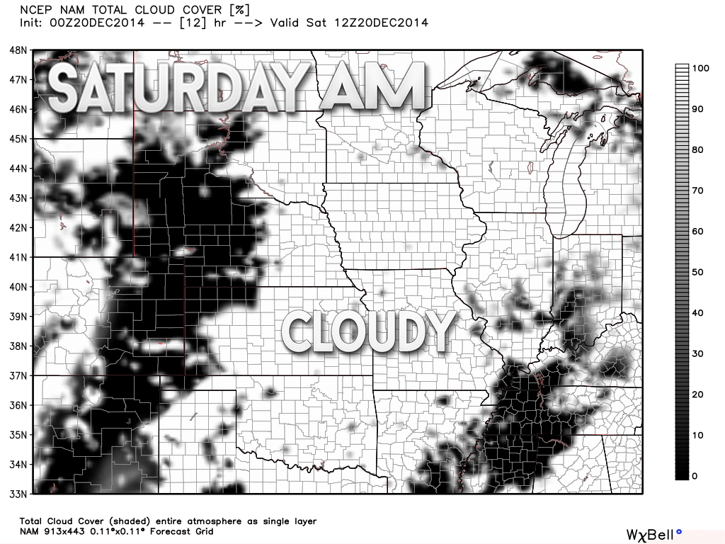
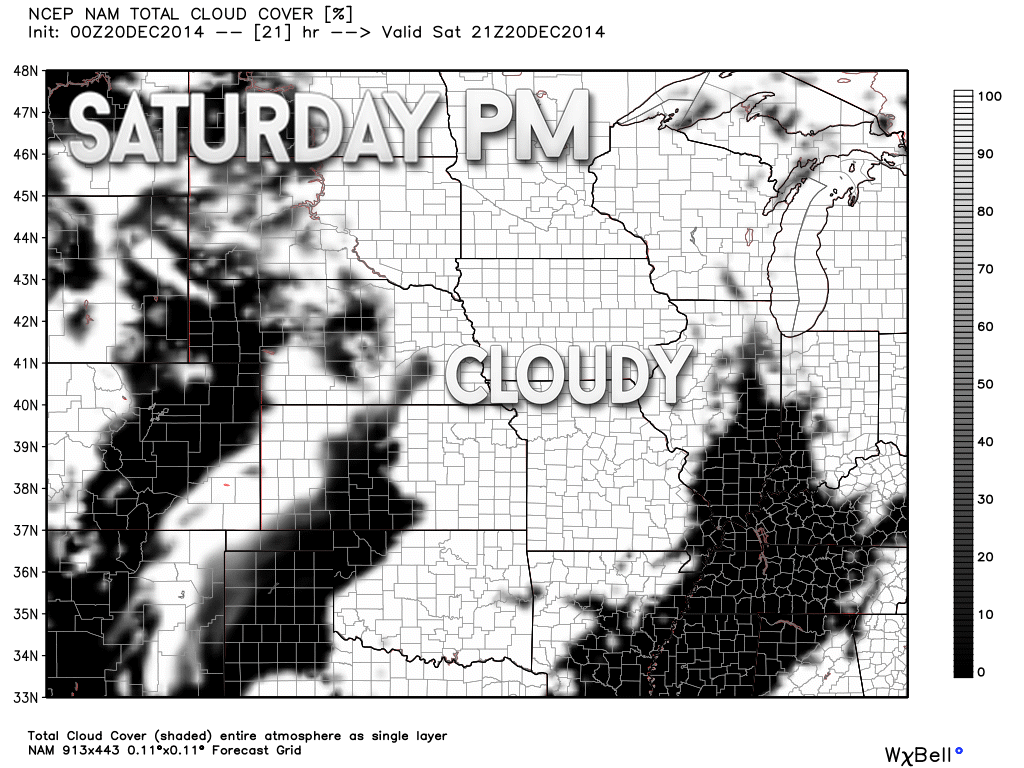
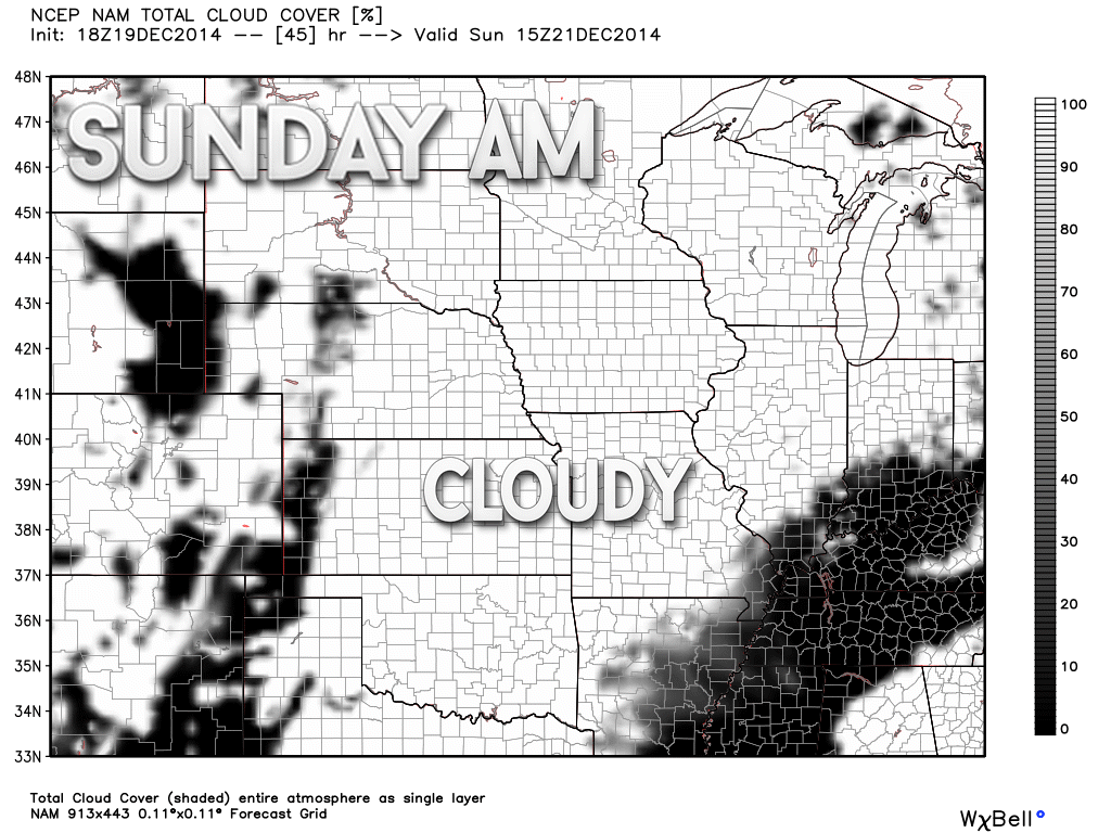
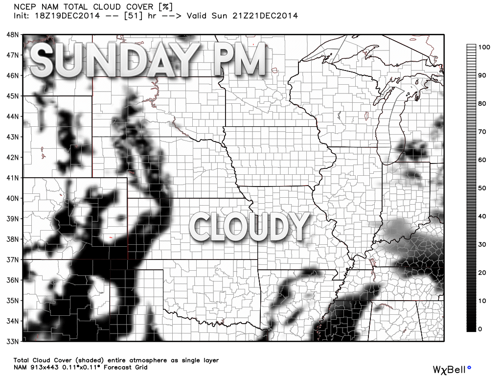
And so there you have it!!!! The tug of war between the clouds and the sunshine! Let’s hope the sun wins at least part of the time.


I increased temperatures a bit for Sunday. Also removed some of the mostly cloudy wording in exchange for some sun. We will see how that goes.

No worries through Monday.

The Wild Card gives you an idea of what might change that would cause the forecast to bust. A busted forecast means a forecast that does not verify.
Wild card in this forecast – simple wild card today! Whether or not we can see more sunshine today and tomorrow vs cloud cover. Crossing fingers! I know everyone would like to see the sun.

Will I need to take action?
No

Please visit your local National Weather Service Office by clicking here. The National Weather Service Office, for our region, is located in Paducah, Kentucky.

How much rain should this system produce over our region?
No significant precipitation is expected through Sunday.

No winter storms through Tuesday. Sorry snow fans! Boy, it has been hard to come by snow during the past month.
Tuesday will bring rain showers, but falling temperatures by Tuesday night could change the rain showers to snow showers. I will be monitoring the latest data as we push into early next week.
Also note – if the low tracks far enough west on Tuesday night then that would increase our chances for precipitation a bit more. That could be in the form of snow. I will be monitoring this topic.
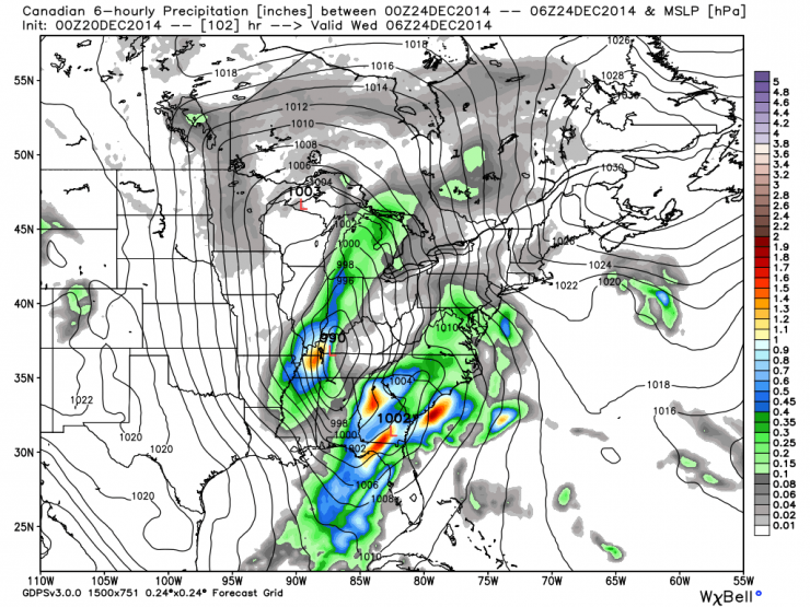
And, the Canadian weather model is showing just that. The low track west and brings quite a bit of precipitation into our region by Tuesday and Tuesday night. What type of precipitation will need to be determined. Definitely worth watching as we move forward. The green, blue, red colors represent precipitation.
We will have at least a chance for flurries or snow showers on Christmas Eve and Christmas Day. Can someone in our area pull off some light accumulation? We shall see! At least a small glimmer of hope for you snow fans.
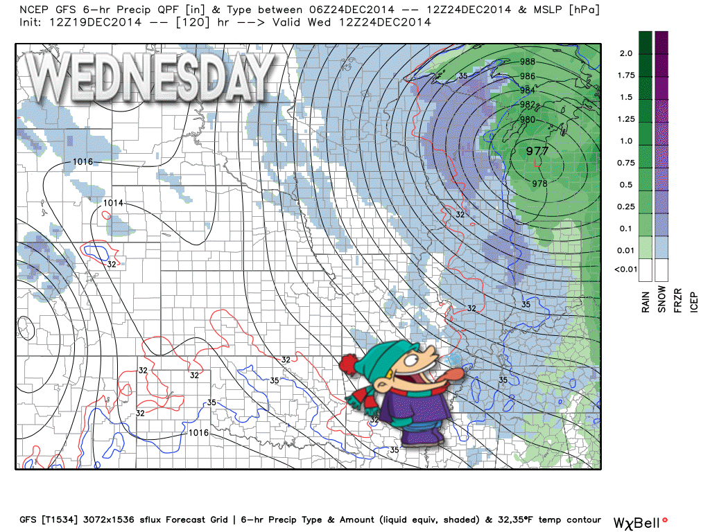
Here is the GFS model showing some light snow showers on Christmas Eve – the snow showers are in blue.
That sure is one wound up low to our north!

The long range forecast continues to look active. There will be another storm system push in from the west by late in the new work week. This could mean showers by Friday or Saturday (maybe even thunderstorms if the system tracks far enough west and north – stay tuned on that subject).
Tuesday night and Wednesday should be colder with gusty winds. Maybe some snow flurries or snow showers? We will see.
I know what some of you want for Christmas
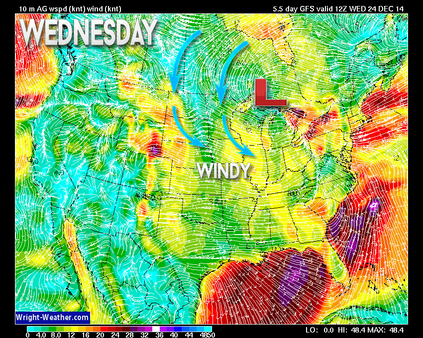
Wednesday (Christmas Eve) will bring gusty winds, as you can see on this wind map. The yellow colors represent 15-30 mph winds. So, with cold temperatures that means it will feel even colder. Perhaps it will even feel like winter. 🙂
This particular image is from www.wright-weather.com
There is a LOT of uncertainty on the weather forecast for next Wednesday through Saturday. Several systems may cause issues across the Central United States.
Christmas Day should have a chilly start but a storm system approaching from the southwest may bring some rise in temperatures late on Christmas Day or the following day.
The 26th-27th we will monitor for another system to bring precipitation into the region. That one may be a warm system. Long way off – plenty of time to change.
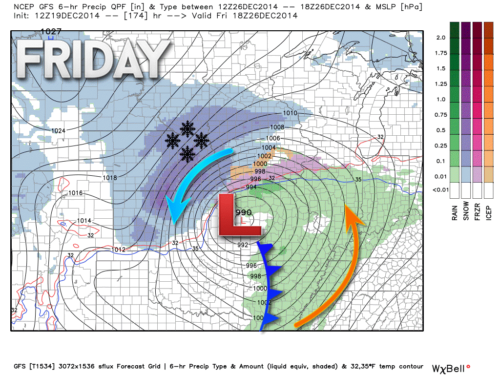
Here is how the GFS model depicts the system for late next week. Another wound up low tracking to our west and northwest. Could we even see some thunderstorms late next week? If the GFS model is correct then the answer is yes. I will be monitoring that system over the coming days, as well. I told you it would be active.
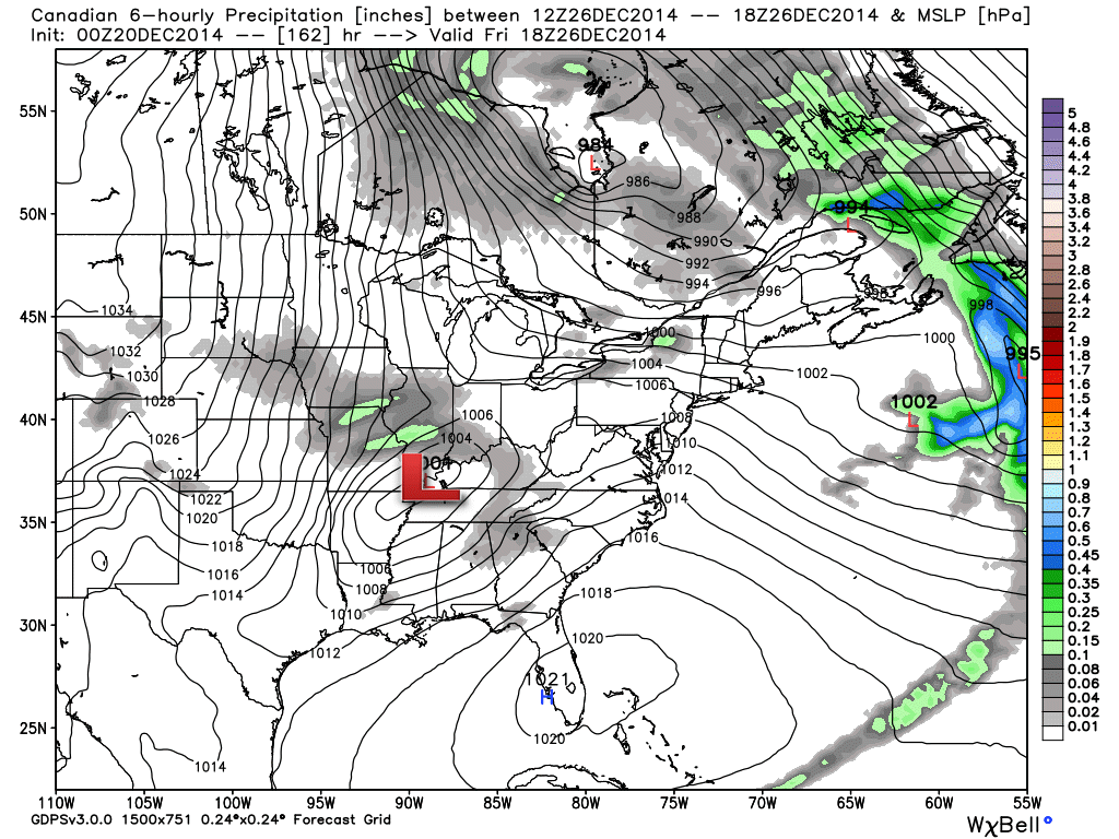
The Canadian model shows this same system, but is quite a bit weaker and tracks it over southern Illinois vs western Missouri.
This is still 6 days away. What I will be watching for are trends in the model data. Track of the area of low pressure and strength of the low.
You can see the low pressure area rotating counter-clockwise. This pulls up mild air ahead of the low. Cold air behind it. You can see the heavy snow to the north/northwest of the low pressure. This image is from www.weatherbell.com
This the map for Friday, December 26th
And here is the Canadian model for the same time period (weaker low and further east with the low). This image is from www.weatherbell.com
After that we may see additional shots of cold air.
Some of the ensembles are showing below normal temperatures the last few days of December and into the first part of January. Long way off.
Many of my graphics are from www.weatherbell.com – a great resource for weather data, model data, and more


This blog was inspired by ABC 33/40’s Alabama Weather Blog – view their blog
Current tower cam view from the Weather Observatory- Click here for all cameras.

Southern Illinois Weather Observatory

The Weather Observatory

Southern Illinois Weather Observatory
WSIL TV 3 has a number of tower cameras. Click here for their tower camera page & Illinois Road Conditions

Marion, Illinois
WPSD TV 6 has a number of tower cameras. Click here for their tower camera page & Kentucky Road Conditions & Kentucky Highway and Interstate Cameras

Downtown Paducah, Kentucky
Benton, Kentucky Tower Camera – Click here for full view

Benton, Kentucky

I24 Paducah, Kentucky

I24 Mile Point 9 – Paducah, KY

I24 – Mile Point 3 Paducah, Kentucky