We have our first sponsor for the blog. Milner and Orr Funeral Home and Cremation Services located in Paducah, Kentucky and three other western Kentucky towns – at Milner and Orr they believe in families helping families.
![]()

This forecast update covers far southern Illinois, far southeast Missouri, and far western Kentucky. See the coverage map on the right side of the blog.
Friday – Mostly cloudy. Cold. High temperatures in the 30’s. Northeast winds at 5-10 mph.
Friday night – Mostly cloudy. Chilly. A flurry possible or light snow showers. Dusting or less on accumulation. Low temperatures in the upper 20’s. Northeast winds at 5-10 mph.
Saturday – Cloudy early then some sun during the afternoon hours. High temperatures from 38 to 44 degrees. North winds at 5-10 mph.
Saturday night – Clearing and cold. Low temperatures in the 20’s. East winds at 5-10 mph.
Sunday – A mix of clouds and sun. It will be on the cool side with high temperatures in the lower to middle 40’s.
Current Temperatures Around The Local Area


An explanation of what is happening in the atmosphere over the coming days.
Good day, everyone! Welcome to the weekend. I suppose some will be out shopping today as Christmas is drawing near. Last minute shoppers? You should not have any weather issues today.
A system to our south will spread clouds and a precipitation shield into the Tennessee Valley today into Saturday morning. This system will mostly stay well south of our local counties. There could be a few light flurries or snow showers over western Kentucky and southern Illinois later tonight and Saturday morning. Not overly excited about the prospects. I did mention it in the forecast. If anything changes today then I will update the blog (the update will appear at the top of the page).
Cool weather for Saturday and Sunday. A mix of sun and some clouds. Perhaps a better chance of sun late on Saturday and then Sunday.
Monday will bring slightly milder air ahead of our next cold front. That system will spread clouds and rain chances back into the region by Monday night and Tuesday. Rainfall totals should be on the light side.
Colder air arrives by Tuesday and Wednesday (maybe some light snow flurries or showers). See the extended forecast discussion further down in the blog.
Tuesday and Wednesday will also be windy.
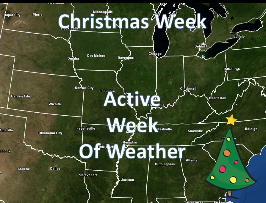
There is A LOT of uncertainty concerning the weather next Tuesday through Friday – several systems may cause problems in the Central United States.
The weather map for Monday night. You can see the low winding up over Iowa and Minnesota. This system will wrap cold air behind it and milder air ahead of it.
Some precipitation could spread into our region on Monday evening and night. Light rain.
These particular images are from www.weatherbell.com
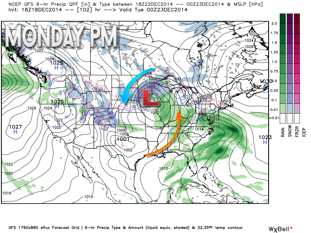
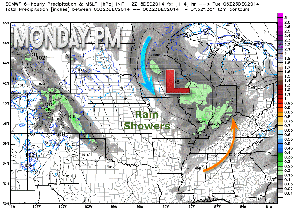
Let me zoom in on the Monday night map.

No real changes to the ongoing forecast. The chances for measurable precipitation on Friday night and Saturday appear slim. Perhaps a few flurries or a snow shower.

No major worries through Sunday.

The Wild Card gives you an idea of what might change that would cause the forecast to bust. A busted forecast means a forecast that does not verify.
Wild card in this forecast – the only wild card in the forecast is whether or not a few locations might see a snow shower or flurries tonight into Saturday morning as a storm system passes to our south.

Will I need to take action?
No

Please visit your local National Weather Service Office by clicking here. The National Weather Service Office, for our region, is located in Paducah, Kentucky.

How much rain should this system produce over our region?
No significant precipitation is expected through Sunday.
If anything falls tonight or Saturday morning it would be very light.

We have regional radars and local city radars – if a radar does not seem to be updating then try another one. Occasional browsers need their cache cleared. You may also try restarting your browser. That usually fixes the problem. Occasionally we do have a radar go down. That is why I have duplicates. Thus, if one fails then try another one.
If you have any problems then please send me an email beaudodson@usawx.com
WEATHER RADAR PAGE – Click here —
We also have a new national interactive radar – you can view that radar by clicking here.
Local interactive city radars include St Louis, Mt Vernon, Evansville, Poplar Bluff, Cape Girardeau, Marion, Paducah, Hopkinsville, Memphis, Nashville, Dyersburg, and all of eastern Kentucky – these are interactive radars. Local city radars – click here
NOTE: Occasionally you will see ground clutter on the radar (these are false echoes). Normally they show up close to the radar sites – including Paducah.

Regional Radar – Click on radar to take you our full radar page.


Chance for flurries or snow showers tonight and Saturday morning. This would be centered more over our southern counties. That would be mostly western Kentucky down into Tennessee. Perhaps southern Illinois, as well. Temperatures should be warm enough in Tennessee to produce mainly a rain event.
To be honest the chances look small for anything more than a novelty snow flake – perhaps dusting on grassy areas. I will monitor and update if the system shifts a little bit further north than expected.

The long range forecast continues to look active. There will be another storm system push in from the north on Monday and Monday night. This might bring some rain showers. Colder air will filter in behind the system.
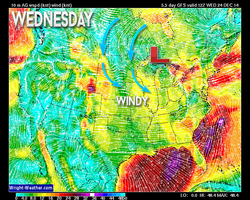
Tuesday and Wednesday should be colder with gusty winds. Maybe some snow flurries or snow showers? We will see.
Wednesday (Christmas Eve) will bring gusty winds, as you can see on this wind map. The yellow colors represent 15-30 mph winds. So, with cold temperatures that means it will feel even colder. Perhaps it will even feel like winter. 🙂
This particular image is from www.wright-weather.com
There is a LOT of uncertainty on the weather forecast for next Tuesday through Friday. Several systems may cause issues across the Central United States.
Christmas Day should have a chilly start but a storm system approaching from the southwest may bring some rise in temperatures late on Christmas Day or the following day.
The 26th-27th we will monitor for another system to bring precipitation into the region. That one may be a warm system. Long way off – plenty of time to change.
After that we may see additional shots of cold air.
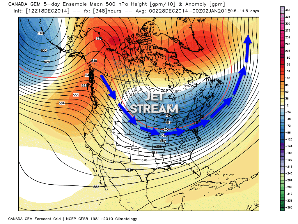
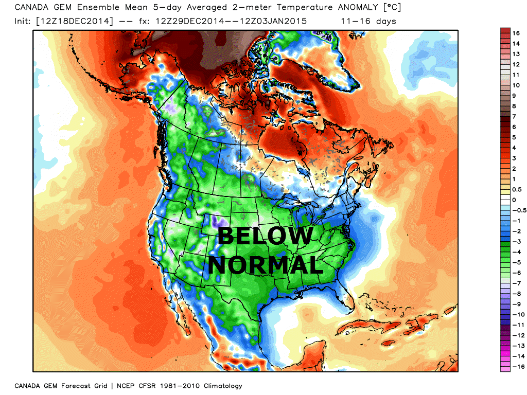
Some of the ensembles are showing below normal temperatures the last few days of December and into the first part of January. Long way off. This is what the maps look like for that time frame.
The first map is the 500 mb upper air map. You can see the arrows coming in from the northwest. That is a strong northwest flow. Northwest flow means colder air for our area.
This particular image is from www.weatherbell.com
This second map is the temperature outlook map for the end of the month into the first few days of January.
Many of my graphics are from www.weatherbell.com – a great resource for weather data, model data, and more


This blog was inspired by ABC 33/40’s Alabama Weather Blog – view their blog
Current tower cam view from the Weather Observatory- Click here for all cameras.

Southern Illinois Weather Observatory

The Weather Observatory

Southern Illinois Weather Observatory
WSIL TV 3 has a number of tower cameras. Click here for their tower camera page & Illinois Road Conditions

Marion, Illinois
WPSD TV 6 has a number of tower cameras. Click here for their tower camera page & Kentucky Road Conditions & Kentucky Highway and Interstate Cameras

Downtown Paducah, Kentucky
Benton, Kentucky Tower Camera – Click here for full view

Benton, Kentucky

I24 Paducah, Kentucky

I24 Mile Point 9 – Paducah, KY

I24 – Mile Point 3 Paducah, Kentucky