December 17, 2014: Good evening, everyone! I hope you had a nice Wednesday?
We do have a weak weather maker approaching our region from the southwest. If you pull up the radars then you can check out the precipitation pushing northeast.
Rain will move into the area later tonight and that rain should be mixed with a little sleet at the beginning. The rain will mix with snow and perhaps a little freezing rain.
Couple of items to think about tonight…
No real changes in my previous forecast thoughts on tonight’s event.
Ground temperatures are warm
Temperatures tonight are going to be marginal for problems (lower 30’s)
Road temperatures are in the 40’s
This is a fast moving and light event
Rain mixing with snow does not accumulate
All of that means that if there were to be any road problems it would likely be on bridges and overpasses.
Temperatures tonight will fall into the lower 30’s.
What does all of that mean?
Perhaps some spots might end up with a dusting or so of snow (if that). The better chances for accumulation would be over southeast Missouri and perhaps parts of southern Illinois where it will be a little cooler.
Precipitation ends by Thursday morning. Thursday and Friday will be cold.
Our next weather maker arrives Friday night and Saturday. I still believe that system will track pretty far south of our region. But, it could still spread some precipitation into the area. Watch for updated information tomorrow.
Radars
http://weatherobservatory.com/weather-radar.htm
Previous post below
We have our first sponsor for the blog. Milner and Orr Funeral Home and Cremation Services located in Paducah, Kentucky and three other western Kentucky towns – at Milner and Orr they believe in families helping families.
![]()

This forecast update covers far southern Illinois, far southeast Missouri, and far western Kentucky. See the coverage map on the right side of the blog.
Wednesday – A mix of sun and clouds. Chilly with below normal temperatures. High temperatures will be in the upper 30’s and lower 40’s. Northwest winds at 5-10 mph.
Wednesday night – Mostly cloudy. A chance for light rain and light snow late at night – sleet possible. There could be some light freezing rain, as well. Main concern would be bridges and overpasses if temperatures can drop down into the upper 20’s or low 30’s. Seasonable temperatures with lows in the upper 20’s and lower 30’s. Winds will be from the north/northeast at 5-10 mph.
Thursday – Mostly cloudy. Cold. Below normal temperatures. Some light rain and light snow possible during the early morning hours. High temperatures will only be in the 30’s. Winds will be from the north/northeast at 5-10 mph.
Thursday night – Mostly cloudy. Chilly. Low temperatures in the upper 20’s. Northeast winds at 5-10 mph.
Friday – Quite a few clouds. It will be on the cool side with below normal temperatures. High temperatures will be in the upper 30’s and lower 40’s. East/northeast winds at 5-10 mph.

Current Temperatures Around The Local Area


An explanation of what is happening in the atmosphere over the coming days.
Today should bring calm weather. A weak weather system approaches the area tonight. This has been the system I have been talking about for awhile (this one and the weekend one).
Right now there have not been any real changes from my previous forecast thoughts.
This system has a lot working against it
1. Temperatures tonight will be marginal for snow. I think a rain and snow mix seems likely. Possibly changing to all snow at the end.
2. Light precipitation overall.
3. Quick moving system.
4. Some dry air aloft to overcome.
5. Road temperatures are not all that cold.
6. Ground temperatures are not all that cold.
It will be difficult for whatever snow develops to accumulate. This is especially true if it is a rain/snow mix. You don’t see much accumulation (if any) when you have a rain/snow mix.
If the rain changes to all snow early tomorrow morning then there would be a small window of time for a dusting.
There is also a chance for some light freezing rain/sleet. If that were to occur then some of the bridges and overpasses might have some slick spots. Again, this is a light event and road temperatures are fairly warm.
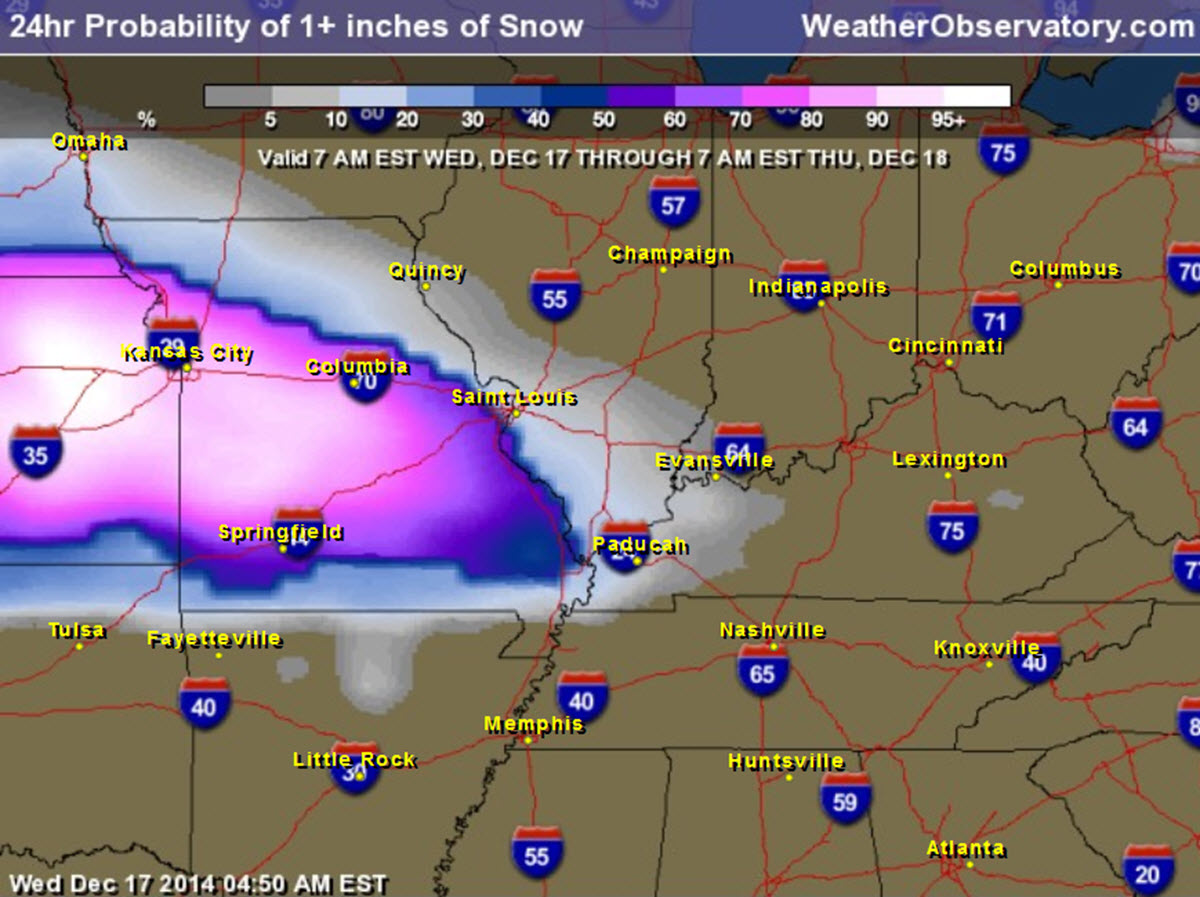
What is the probability of 1″ of snow tonight? You can see the numbers spike over our western counties.
Click image for larger view

Thursday and Friday will bring a mix of sun and clouds. Temperatures will remain below normal.

I did not change much to the ongoing forecast. Adjusted temperatures and cloud cover just a bit.
Added mention of light freezing rain tonight. Road temperatures are warm, but bridges and overpasses can always get slick spots when temperatures fall below freezing.

Concerns center around the system later tonight and on Thursday morning. Marginal event to produce snow in our region. If everything comes together then there might be some slick spots on Thursday morning.

The Wild Card gives you an idea of what might change that would cause the forecast to bust. A busted forecast means a forecast that does not verify.
Wild card in this forecast – pretty obvious wild card today. Will the storm system tonight be able to produce accumulating snow over portions of our area. This is a marginal event – see the longer discussion above.

Will I need to take action?
If snow does develop tonight then we will have to watch for a few slick spots on Thursday morning. Road temperatures will be marginal for problems. Salt has been placed on area roads. The precipitation event should be light. The precipitation event will likely be mixed with rain.

Please visit your local National Weather Service Office by clicking here. The National Weather Service Office, for our region, is located in Paducah, Kentucky.

How much rain should this system produce over our region?
Precipitation totals tonight and Thursday morning will be on the light side.

We have regional radars and local city radars – if a radar does not seem to be updating then try another one. Occasional browsers need their cache cleared. You may also try restarting your browser. That usually fixes the problem. Occasionally we do have a radar go down. That is why I have duplicates. Thus, if one fails then try another one.
If you have any problems then please send me an email beaudodson@usawx.com
WEATHER RADAR PAGE – Click here —
We also have a new national interactive radar – you can view that radar by clicking here.
Local interactive city radars include St Louis, Mt Vernon, Evansville, Poplar Bluff, Cape Girardeau, Marion, Paducah, Hopkinsville, Memphis, Nashville, Dyersburg, and all of eastern Kentucky – these are interactive radars. Local city radars – click here
NOTE: Occasionally you will see ground clutter on the radar (these are false echoes). Normally they show up close to the radar sites – including Paducah.

Regional Radar – Click on radar to take you our full radar page.


I have already discussed the light precipitation event that is on tap for tonight.
That leaves us with the Friday and Saturday system. I am still not overly impressed with the setup. That event had the best potential to bring a winter storm to the Ohio and/or Tennessee Valley. It all depended on the track. My thinking has been it would take a southern track. That appears to be what will happen.
The next question is just how far south will it track and just how strong will the system be (or not be).
We still have several days to monitor that system. Right now I continue to believe that the odds of it bringing a winter storm to our region are about 2 in 10.
If precipitation does spread into our region then it would likely be in the form of snow for our northern counties and a rain/snow mix for our southern counties changing to snow. If the system is far enough north then some light accumulation can’t be ruled out.
This is all highly dependent on the placement of the area of low pressure. Monitor updates.

Christmas week might be active over the eastern half of the United States. We are going to have several storm systems to monitor. Too early, of course, to talk details.
There seems to be an overall push towards a pattern change as we move into next week. This could trigger some arctic air to finally filter down into the United States.
I know a lot of people have travel plans as we move into late this weekend and next week. Stay tuned and monitor updates.
I will try to plug all the data in and make some sense out of it.

Many of my graphics are from www.weatherbell.com – a great resource for weather data, model data, and more


This blog was inspired by ABC 33/40’s Alabama Weather Blog – view their blog
Current tower cam view from the Weather Observatory- Click here for all cameras.

Southern Illinois Weather Observatory

The Weather Observatory

Southern Illinois Weather Observatory
WSIL TV 3 has a number of tower cameras. Click here for their tower camera page & Illinois Road Conditions

Marion, Illinois
WPSD TV 6 has a number of tower cameras. Click here for their tower camera page & Kentucky Road Conditions & Kentucky Highway and Interstate Cameras

Downtown Paducah, Kentucky
Benton, Kentucky Tower Camera – Click here for full view

Benton, Kentucky

I24 Paducah, Kentucky

I24 Mile Point 9 – Paducah, KY

I24 – Mile Point 3 Paducah, Kentucky