We have our first sponsor for the blog. Milner and Orr Funeral Home and Cremation Services located in Paducah, Kentucky and three other western Kentucky towns – at Milner and Orr they believe in families helping families.
![]()

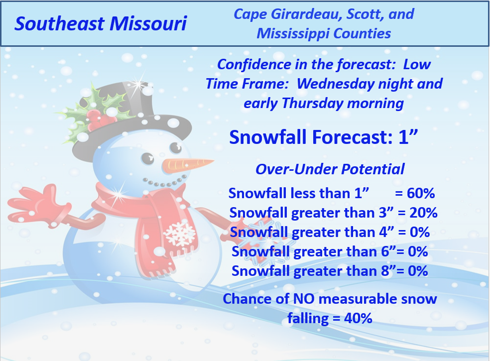
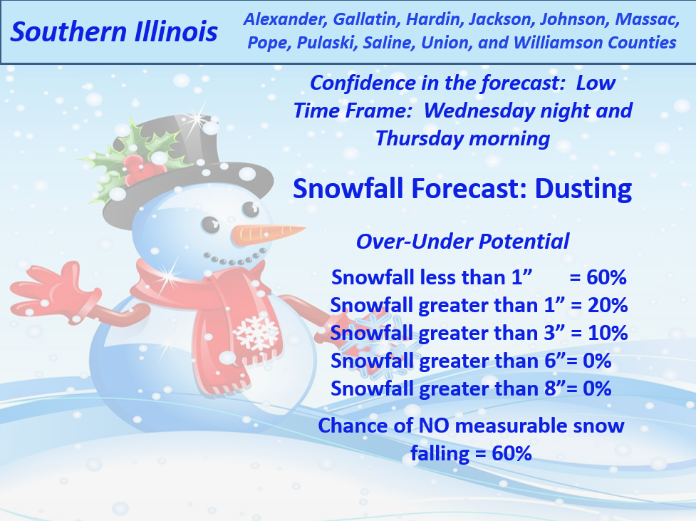
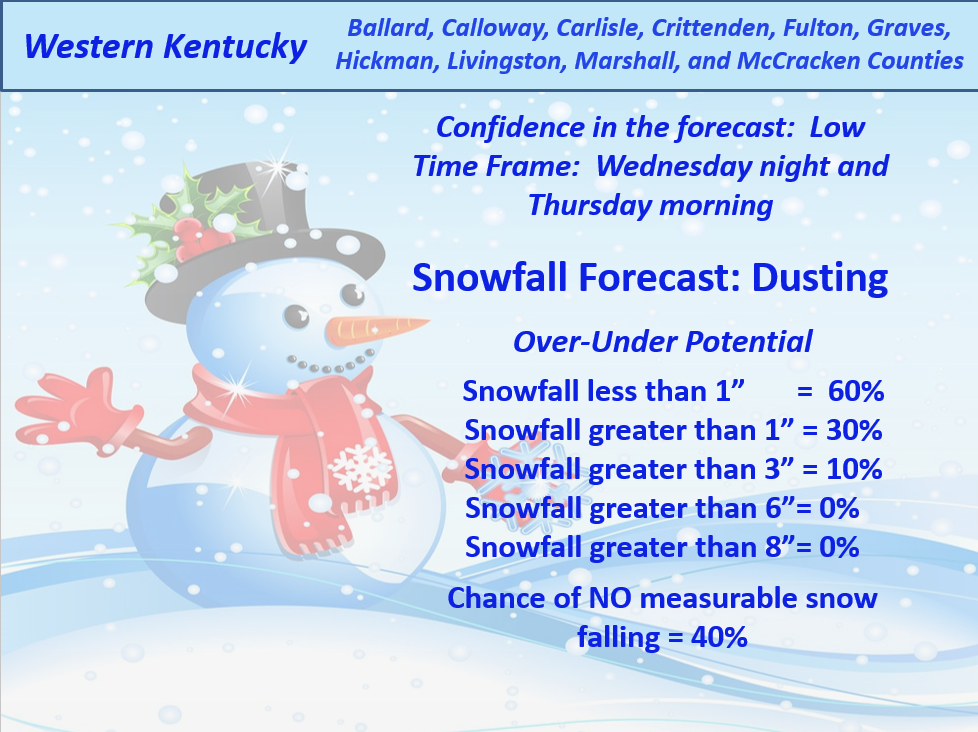
This forecast update covers far southern Illinois, far southeast Missouri, and far western Kentucky. See the coverage map on the right side of the blog.
I may update the blog a couple of times today. If I do update the blog then it will show up at the top of the page.
Tuesday – Mostly cloudy. It will be on the cool side. Windy at times. High temperatures in the lower to middle 40’s. West/northwest winds at 10-20 mpg – gusty at times.
Tuesday night – Mostly cloudy. Seasonable temperatures with lows in the upper 20’s and lower 30’s. West/northwest winds at 5-10 mph.
Wednesday – Mostly cloudy. Cold with well below normal temperatures. Highs will only be in the 30’s. North winds at 5-10 mph.
Wednesday night – Mostly cloudy. A chance for light rain and light snow late at night. Seasonable temperatures with lows in the upper 20’s and lower 30’s. Winds will be from the north/northeast at 5-10 mph.
Thursday – Mostly cloudy. Cold. Some light rain and light snow possible during the early morning hours. High temperatures will only be in the 30’s. Winds will be from the north/northeast at 5-10 mph.
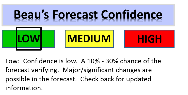
MEDIUM CONFIDENCE in the overall forecast and LOW confidence on the Wednesday night precipitation event.

Current Temperatures Around The Local Area


An explanation of what is happening in the atmosphere over the coming days.
Welcome to Tuesday! I hope everyone enjoyed the showers on Monday? Nothing like clouds and rain on Monday.
I am guessing you have tuned in today to check on the snow chances for Wednesday night and Thursday and then again late this week.
No real change from my long thoughts on Monday – see that post for details.
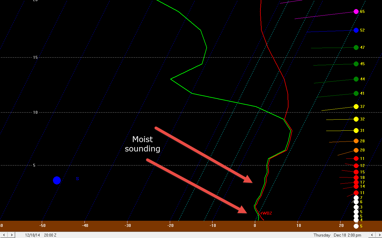
Some light precipitation arrives on Wednesday night. This does not look to be a big deal. There is some dry air to overcome early on with this precipitation event, however, the atmosphere does moisten up as we move through Wednesday night. This sounding for Paducah (a slice in the atmosphere that meteorologists use to determine weather conditions) does show the atmosphere becoming moist and the dry air eroding away. When the green line hugs the red line that means the atmosphere has moistened up.
Sometimes dry air aloft will eat into the precipitation and you end up with virga (precipitation falling from the sky, but not reaching the ground)
The SREF model plumes (this is an ensemble models which means the same model, but tweaked a little bit and run again – the more tightly clustered each run of the model equals the better chance of verification of the forecast)
You can see the SREF model is spitting out about 0.08″ of precipitation for Paducah, Kentucky. The black line represents the mean. The lines around it represents the over/under outcomes.
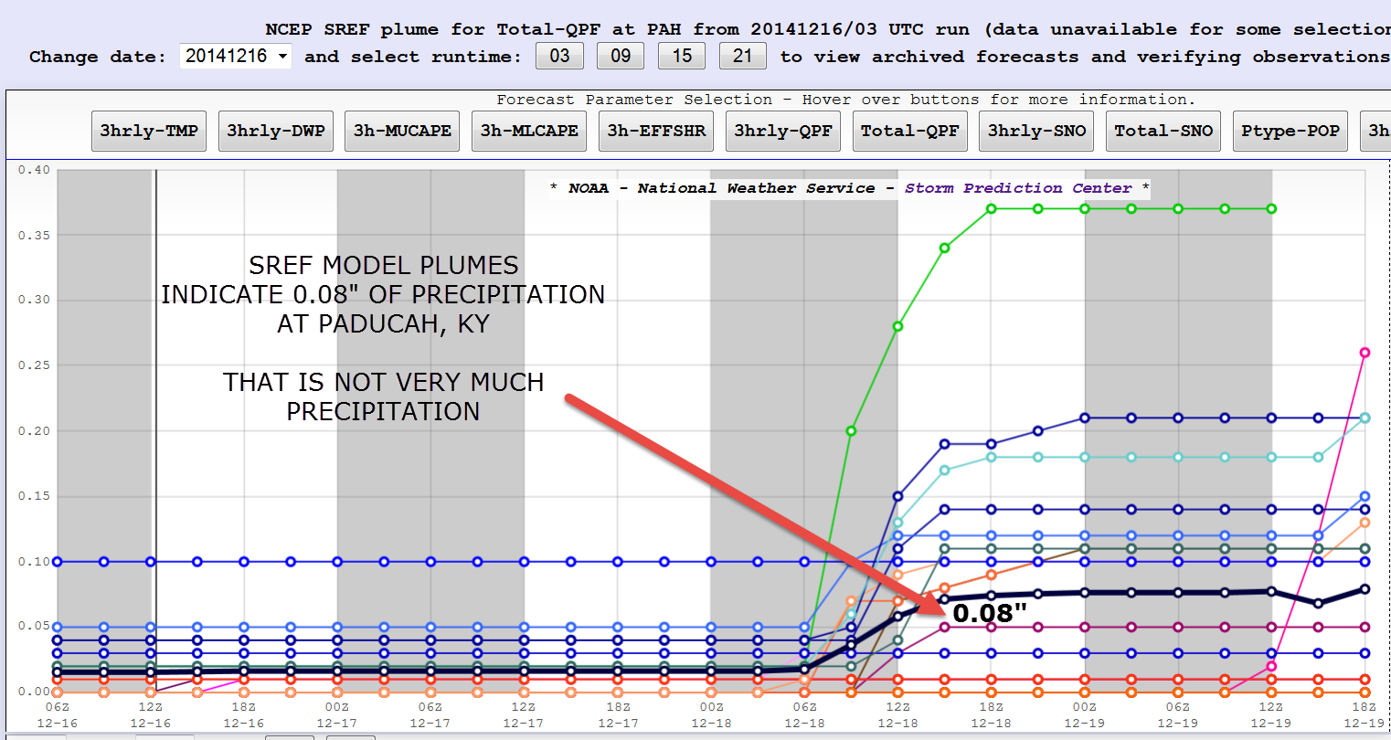
ENGLISH PLEASE! The black line represents the most likely outcome for precipitation totals on Wednesday night and Thursday morning. Obviously 0.08″ of precipitation is not much. If that were all rain then you would hardly know it rained. If that were all snow and the ground was cold enough for the snow to stick then that might be a dusting of snow to perhaps 1″ of snow.
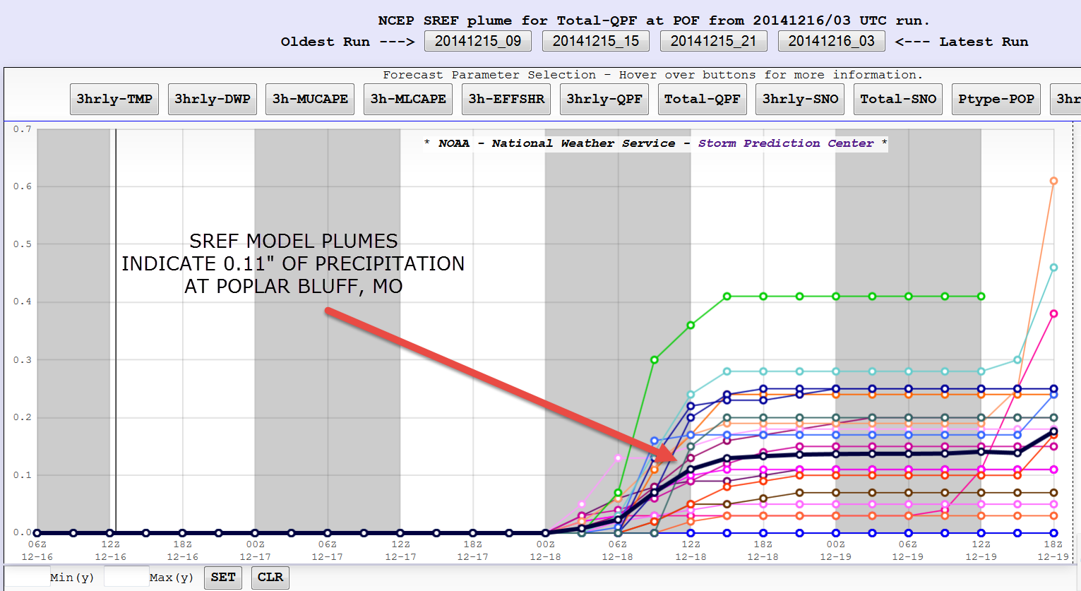
Let’s take a quick look at Poplar Bluff, Missouri. Note there is quite a bit more spread at Poplar Bluff. That means there is at least a chance for a bit more precipitation to fall there. That does make sense as the system is forecast to weaken as it moves over our area. The best chance for slightly higher amounts of precipitation would be over our southwest counties.
Con’s/negatives about this snow accumulating
1. Ground temperature is not that cold.
2. Precipitation will be rain and snow mix (not the best for accumulation)
3. Quick moving system
4. Perhaps a little bit of dry air to overcome at the beginning of the event.
We may see a dusting of snow in places and perhaps up to an inch. I am not overly confident in this event. Here are my probability graphics. Lower than normal confidence on the Wednesday night and Thursday morning weather conditions.
Keep that in mind.
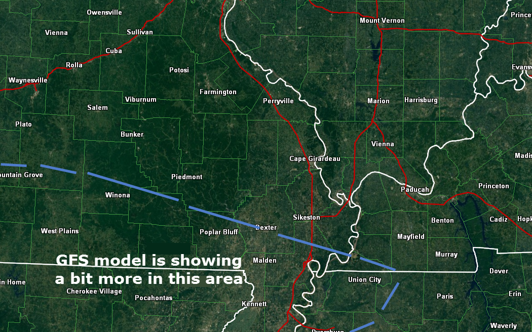
The GFS model actually shows a bit more snowfall Wednesday night and Thursday morning along a line from near Poplar Bluff, MO over towards southwest Kentucky – Fulton, KY. It is showing 1″-3″ of snow along this line.
But, again – with marginal air temperatures, ground temperatures not all that cold, and a mix of rain and snow…just not sure how much can accumulate.
Note that I added the LOW confidence forecast graphic to the Wednesday night event. That means my confidence is low on how this turns out. Let’s see how today’s data looks as it rolls in.

Went ahead and just made sky conditions mostly cloudy for the next few days. If we do end up with some sunny breaks then GREAT 🙂
Added snowfall graphics.

Watching Wednesday night and Thursday for precipitation chances. If this were to occur then it could be a mixture of precipitation – rain and snow. The overall chance for more than 0.10″ of precipitation appears small. Remember that 0.10″ of liquid precipitation equals about 1″ of snow. 1″ of snow melted down usually equals around 0.10″ of liquid. Hope that makes sense 🙂 – 1″ of snow does NOT equal 1″ of rain. There is usually a 10:1 ratio.
Precipitation amounts, either way, should be light.
I am more concerned about the potential for a winter weather event or a precipitation maker towards the end of the work week.

The Wild Card gives you an idea of what might change that would cause the forecast to bust. A busted forecast means a forecast that does not verify.
Wild card in this forecast – the wild card for this forecast is whether or not snow will be able to accumulate on Wednesday night and Thursday morning.

Will I need to take action?
No

Please visit your local National Weather Service Office by clicking here. The National Weather Service Office, for our region, is located in Paducah, Kentucky.

How much rain should this system produce over our region?
No precipitation through Wednesday afternoon.

I am monitoring two systems over the next few days.
System one arrives on Wednesday night and Thursday.
If precipitation occurs on Wednesday night and Thursday then it would be a mix of rain and snow. Again, light event. Overall chances for measurable precipitation appear small.
The second system is on Friday and Saturday. This system will be tracking to our south. If the system is far enough north then we may have to deal with all sorts of precipitation. Stay tuned.
I am hoping to have a better handle on the late week system by late tonight and on Wednesday morning.
I am watching a system around December 23rd-26th. I have been talking about this system for about 2 weeks now. Way way early to know the track and/or intensity of that particular event.
Many of my graphics are from www.weatherbell.com – a great resource for weather data, model data, and more


This blog was inspired by ABC 33/40’s Alabama Weather Blog – view their blog
Current tower cam view from the Weather Observatory- Click here for all cameras.

Southern Illinois Weather Observatory

The Weather Observatory

Southern Illinois Weather Observatory
WSIL TV 3 has a number of tower cameras. Click here for their tower camera page & Illinois Road Conditions

Marion, Illinois
WPSD TV 6 has a number of tower cameras. Click here for their tower camera page & Kentucky Road Conditions & Kentucky Highway and Interstate Cameras

Downtown Paducah, Kentucky
Benton, Kentucky Tower Camera – Click here for full view

Benton, Kentucky

I24 Paducah, Kentucky

I24 Mile Point 9 – Paducah, KY

I24 – Mile Point 3 Paducah, Kentucky