

This forecast update covers far southern Illinois, far southeast Missouri, and far western Kentucky. See the coverage map on the right side of the blog.
Monday – A period of rain showers likely this morning. a rumble of thunder possible. Otherwise, cloudy. A second round of showers possible late this afternoon and evening – right ahead of the cold front. South/southeast winds at 10-15 mph. Winds may gust to 20 mph.
Monday night – A few showers possible during the evening hours. Turning cooler. Low temperatures will be in the upper 30’s and lower 40’s. West/northwest winds at 5-15 mph. Gusts to 25 mph behind the front.
Tuesday – A mix of sun and clouds. Cooler. High temperatures only in the 40’s. Northwest winds at 10-15 mph.
Tuesday night – Mostly cloudy. Cold. Low temperatures in the upper 20’s and lower 30’s. Northwest winds at 10 mph.
Wednesday – Mostly cloudy. Cool. High temperatures only in the upper 30’s and perhaps lower 40’s. Northwest winds at 10 mph.

Current Temperatures Around The Local Area

National temperature map – note the warm surge of air ahead of our storm system. Colder air behind the system.

Current dew points – note how the higher dew points (moisture available in the atmosphere) is surging northward ahead of our storm.


An explanation of what is happening in the atmosphere over the coming days.
GOOD Monday morning, everyone! I hope you enjoyed your mostly cloudy weekend? Certainly the temperatures on Sunday afternoon must have made you smile? Temperatures FINALLY overachieved. It has been a long time coming. You have earned your upper 50’s and even a few 60’s! I hope you didn’t get used to those temperatures? If so then you better head south.
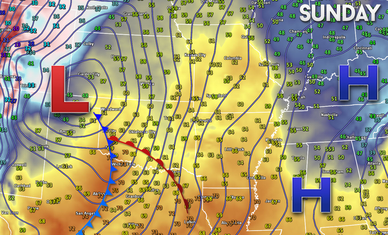
Here was the Sunday evening weather map. You can see the area of low pressure over the Oklahoma Panhandle. The warm front over Oklahoma. The cold front over Texas. The warm air surging northward ahead of our low. The cold air behind the low. The numbers represent temperatures around 4 pm. Click the map for a larger view.
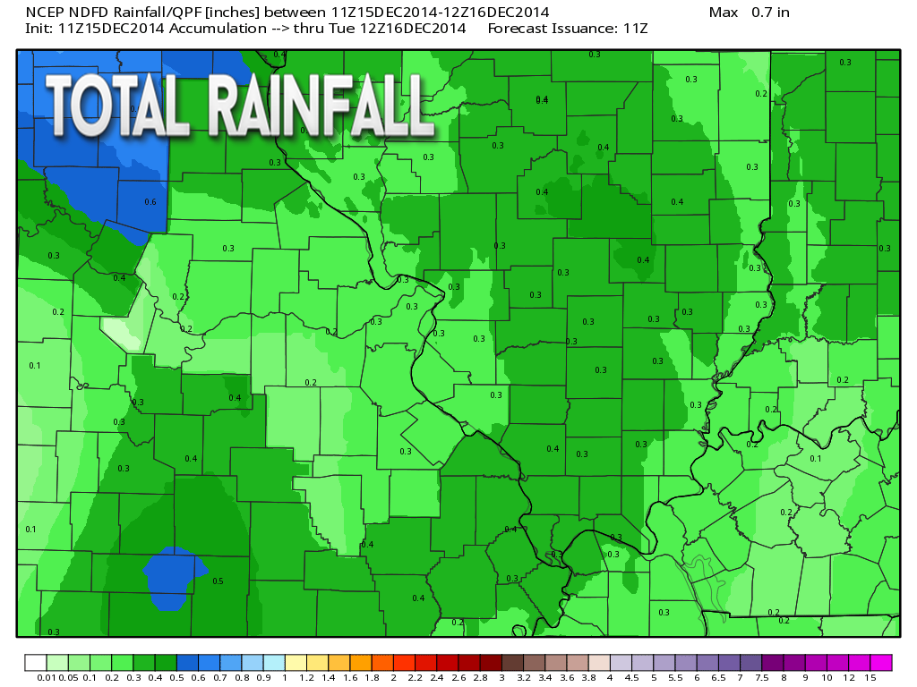
Our next storm system is knocking at the door this morning. Rain will be pushing through southeast Missouri this morning and entering southern Illinois and western Kentucky as the morning wears on. Rainfall totals should be on the light side today. I suspect most areas will pick up less than 0.25″.
There may be a couple of spots that pick up a bit more. There are some embedded heavier showers within the line.
Radars are up and running – check them out if you want to track the rain.
Click here for radars
Another small band of showers MAY develop this evening right along the cold front. Some uncertainty around this topic. Atmospheric profiles indicate there may be a chance for a rumble of thunder, as well. The evening showers will quickly push eastward as the evening wears on. This will leave clouds and cooler temperatures.
You can see our current storm on the water vapor satellite image. See the counter-clockwise shape of the moisture/clouds. They are winding up around our area of low pressure situated over northern Missouri and Iowa.

Clouds will likely linger into Tuesday and Wednesday. There is some debate in the meteorological community about cover on Wednesday. But, do you really care about that? I am guessing not too much. But, keep that in mind. If we are lucky then clouds will thin and some sun will pop out. Either way, it will remain cool.
Another chance for precipitation arrives Wednesday night and Thursday. Confidence in this happening is very low. If moisture does spread back into the area then a mixture of sleet and snow would primarily be the precipitation type. I am not completely sold on this happening and am giving this the LOW CONFIDENCE rating. I should have a better idea on this topic later tonight.
If this does happen then the southern half and western half of the region stands the best chance of precipitation. Again – this is a big big big IF it happens at all.
This is where I would draw the line for precipitation chances…

Did add the mention of a heavier downpour in a few of the showers this morning.

Watching Wednesday night and Thursday for precipitation chances. If this were to occur then it could be frozen.
The Wednesday event looks like and I am not overly confident that it produces much at all.
I am much more concerned about the Friday and Saturday system. Anyone with travel plans later this week and weekend should monitor updates. A winter weather event could occur somewhere in or near our region. Still plenty of time for fine tuning on that one.

The Wild Card gives you an idea of what might change that would cause the forecast to bust. A busted forecast means a forecast that does not verify. For example, if a winter storm (the area of low pressure) shifts its track 50 miles further south than expected, then that could cause a dramatic change in how much snow might or might not accumulate.
Wild card in this forecast – the wild card for this forecast is going to be cloud cover on Wednesday and then precipitation chances late Wednesday night and Thursday. Low confidence on whether clouds can thin on Wednesday. Low confidence on whether we will experience precipitation on Wednesday night and Thursday.

Can we expect severe thunderstorms over the next 24 to 48 hours? Remember that a severe thunderstorm is defined as a thunderstorm that produces 58 mph winds or higher, quarter size hail or larger, and/or a tornado.
Thunderstorm threat level is ONE – some thunder possible.


Live Lightning Data – zoom and pan: Click here
Live Lightning Data with sound (click the sound button on the left side of the page): Click here

Will I need to take action?
Umbrellas this morning and again perhaps this evening!

Please visit your local National Weather Service Office by clicking here. The National Weather Service Office, for our region, is located in Paducah, Kentucky.

How much rain should this system produce over our region?
Rain pushes in this morning. A downpour is possible with some of the rain showers. Here are the general rainfall totals. There could be some locally heavier amounts. The line of showers is a little heavier than anticipated. We shall see how it goes.
Everyone should experience at least some rainfall.

We have regional radars and local city radars – if a radar does not seem to be updating then try another one. Occasional browsers need their cache cleared. You may also try restarting your browser. That usually fixes the problem. Occasionally we do have a radar go down. That is why I have duplicates. Thus, if one fails then try another one.
If you have any problems then please send me an email beaudodson@usawx.com
WEATHER RADAR PAGE – Click here —
We also have a new national interactive radar – you can view that radar by clicking here.
Local interactive city radars include St Louis, Mt Vernon, Evansville, Poplar Bluff, Cape Girardeau, Marion, Paducah, Hopkinsville, Memphis, Nashville, Dyersburg, and all of eastern Kentucky – these are interactive radars. Local city radars – click here
NOTE: Occasionally you will see ground clutter on the radar (these are false echoes). Normally they show up close to the radar sites – including Paducah.

Regional Radar – Click on radar to take you our full radar page.


Well, here we go. Let the “will it snow or won’t it snow” games begin.
We have one system that I am watching for Wednesday night and Thursday morning. I am not confident that this system will be able to hold together long enough to bring our region snow and sleet. If it does hold together then we may have to introduce snow and sleet chances for at least portions of the region. This would primarily be along a line from Rolla, Missouri southeast towards Cape Girardeau, Missouri and then southeast over far southern Illinois and into western Kentucky towards the Land Between the Lakes. Again, not sold on this happening, yet. Check back for updates.
Another storm system may spread precipitation into the Ohio and/or Tennessee Valleys by Friday and Saturday. This should be a southern track system. Anyone with travel plans later this week should closely monitor updated forecasts. A winter weather event is possible somewhere near our region.
The big question surrounding the late week system is how far south will the area of low pressure track. Remember that if the low tracks to our south then we are on the cold side of the storm. If the system goes too far south then we won’t receive any precipitation – we may just wave hello to the clouds as they pass to our south.
The late week system does at least have the potential to produce a wintry event near our region. Stay tuned for updates as we push deeper into the work week. I don’t think I will have a handle on the track of the area of low pressure until Wednesday. Still several days to monitor and speculate.
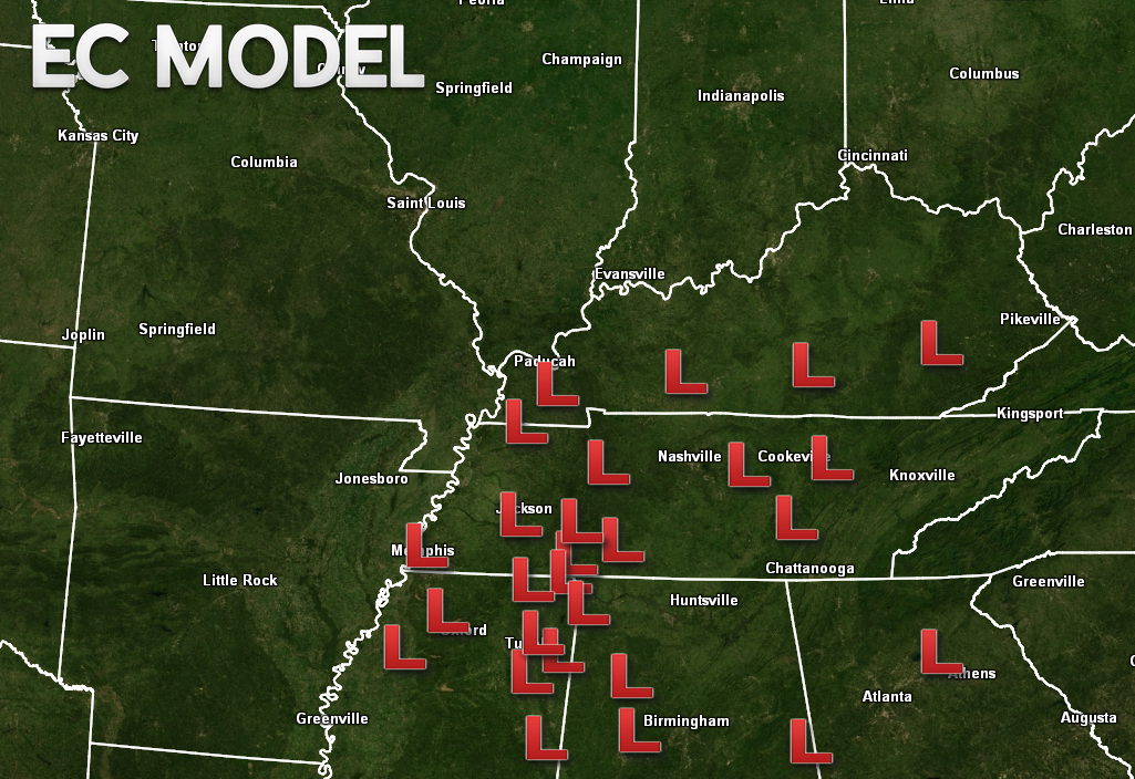
The EC model ensembles are showing the track of the low clustered somewhere in the Tennessee Valley. Ensembles are the same model but tweaked a little bit with different data. The idea is that if the majority of the ensembles come up with the same solution then that is the most likely scenario. I put this together this morning giving you a rough idea of where the EC is tracking the area of low pressure.
Neither of these winter systems are a sure bet — by any stretch of the imagination (I know some forecasters are promising snow). Don’t count your snowflakes before they hatch.


The main concerns are mentioned above.
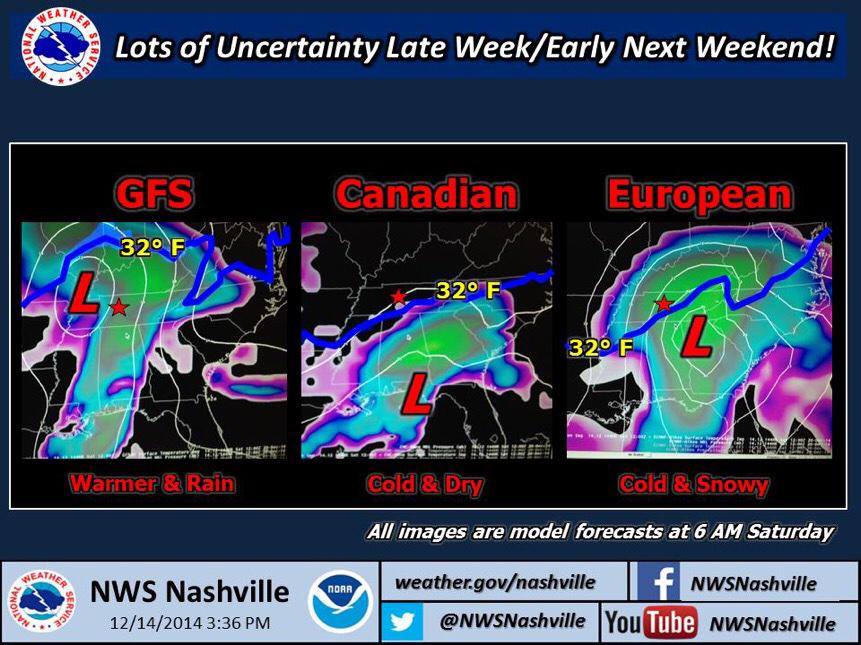
Let me show you this graphic from the Nashville, TN National Weather Service. This really does sum up how important it is to monitor the track of the area of low pressure. The EXACT track is key to what happens in our region.
I am watching a couple of systems for the week of Christmas. Colder air seems a good bet as we push into this week and then lasting into the first week of January.
As promised over the past week or two – we are entering a very active weather pattern as we push the last half of December. Again, stay tuned.
Many of my graphics are from www.weatherbell.com – a great resource for weather data, model data, and more


This blog was inspired by ABC 33/40’s Alabama Weather Blog – view their blog
Current tower cam view from the Weather Observatory- Click here for all cameras.

Southern Illinois Weather Observatory

The Weather Observatory

Southern Illinois Weather Observatory
WSIL TV 3 has a number of tower cameras. Click here for their tower camera page & Illinois Road Conditions

Marion, Illinois
WPSD TV 6 has a number of tower cameras. Click here for their tower camera page & Kentucky Road Conditions & Kentucky Highway and Interstate Cameras

Downtown Paducah, Kentucky
Benton, Kentucky Tower Camera – Click here for full view

Benton, Kentucky

I24 Paducah, Kentucky

I24 Mile Point 9 – Paducah, KY

I24 – Mile Point 3 Paducah, Kentucky