We have some great sponsors for the Weather Talk Blog. Please let our sponsors know that you appreciate their support for the Weather Talk Blog.
Milner and Orr Funeral Home and Cremation Services located in Paducah, Kentucky and three other western Kentucky towns – at Milner and Orr they believe in families helping families. You can find Milner and Orr on Facebook, as well.
![]()
.

Wortham Dental Care located in Paducah, Kentucky. The gentle dentist. Mercury free dentistry. They also do safe Mercury removal. You can find Wortham Dental Care on Facebook, as well
.

For all of your families eye care needs. Visit their web-site here. Or, you can also visit their Facebook page.
.

Endrizzi’s Storm Shelters – For more information click here. Endrizzi Contracting and Landscaping can be found on Facebook, as well – click here
.

Best at Enabling Body Shop Profitability since 1996. Located In Paducah Kentucky and Evansville Indiana; serving all customers in between. They provide Customer Service, along with all the tools necessary for body shops to remain educated and competitive. Click the logo above for their main web-site. You can find McClintock Preferred Finishes on Facebook, as well
.

Duck/goose decoys? Game calls? Optics? We have you covered! Click the logo above or visit Final Flight on Facebook, as well.

This forecast update covers far southern Illinois, far southeast Missouri, and far western Kentucky. See the coverage map on the right side of the blog.
Remember that weather evolves. Check back frequently for updates, especially during active weather.
WEATHER RADAR PAGE – Click here —
Sunday night – Cloudy. Windy. Widespread rain. A small chance for a rumble of thunder.
Temperatures: Lows in the upper 40s to lower 50s
Winds: South and southwest winds at 10-20 mph with gusts above 35+ mph.
What is the chance for precipitation? 100%
Coverage of precipitation? Widespread
My confidence in this part of the forecast verifying is High
Should I be concerned about snow or ice? No
Should I cancel my outdoor plans? Have a plan B.
Is severe weather expected? No, but strong winds likely with the cold front.
What impact is expected? Wet roadways. Strong and gusty winds. Rumble of thunder possible (small chance)
Monday – Cloudy. Perhaps some morning showers. Windy at times. Decreasing clouds possible later in the day.
Temperatures: Highs in the 54 to 58 degree range. Temperatures might not rise much on Monday
Winds: Southwest/west winds at 10-20 mph with gusts above 30 mph.
What is the chance for precipitation? 30% early in the morning. Decreasing chances as the day wears on.
Coverage of precipitation? Scattered early in the morning
My confidence in this part of the forecast verifying is High
Should I be concerned about snow or ice? No
Should I cancel my outdoor plans? No
Is severe weather expected? No
What impact is expected? Wet roadways in the morning. Gusty winds.
Monday night – Mostly clear and colder.
Temperatures: Lows in the upper 30s to lower 40s
Winds: West/southwest wind at 8-16 mph
What is the chance for precipitation? 0%
Coverage of precipitation? None
My confidence in this part of the forecast verifying is High
Should I be concerned about snow or ice? No
Should I cancel my outdoor plans? No
Is severe weather expected? No
What impact is expected? None
Tuesday – Mostly sunny. Mild again.
Temperatures: Highs in the 56 to 62 degree range
Winds: South/southwest winds at 10-20 mph.
What is the chance for precipitation? 0%
Coverage of precipitation? None
My confidence in this part of the forecast verifying is High
Should I be concerned about snow or ice? No
Should I cancel my outdoor plans? No
Is severe weather expected? No
What impact is expected? None
Tuesday night – A few patchy clouds. Otherwise clear.
Temperatures: Lows in the middle to upper 40s.
Winds: West/southwest wind at 10 mph
What is the chance for precipitation? 20%
Coverage of precipitation? Isolated
My confidence in this part of the forecast verifying is High
Should I be concerned about snow or ice? No
Should I cancel my outdoor plans? No
Is severe weather expected? No
What impact is expected? No serious impacts
Wednesday – Some clouds. A chance for a shower.
Temperatures: Highs in the 54 to 58 degree range
Winds: West/southwest winds at 6-12 mph.
What is the chance for precipitation? 30%
Coverage of precipitation? Isolated.
My confidence in this part of the forecast verifying is High
Should I be concerned about snow or ice? No
Should I cancel my outdoor plans? No
Is severe weather expected? No
What impact is expected? Spotty wet roadways perhaps
Wednesday night – Some clouds. Colder. Small chance for evening precipitation.
Temperatures: Lows in the middle to upper 30s
Winds: West/northwest wind at 10 mph
What is the chance for precipitation? 10%
Coverage of precipitation? Isolated
My confidence in this part of the forecast verifying is Medium
Should I be concerned about snow or ice? No
Should I cancel my outdoor plans? No
Is severe weather expected? No
What impact is expected? None
Thursday – Partly cloudy and colder.
Temperatures: Highs in the 44 to 48 degree range
Winds: Northeast winds at 5-10 mph.
What is the chance for precipitation? 0%
Coverage of precipitation? None expected
My confidence in this part of the forecast verifying is Low
Should I be concerned about snow or ice? No
Should I cancel my outdoor plans? No
Is severe weather expected? No
What impact is expected? None
Dry weather should continue Friday, Saturday, and Sunday.

Click their ad below to visit their web-site or click here reedelec.com


Don’t forget to check out the Southern Illinois Weather Observatory web-site for weather maps, tower cams, scanner feeds, radars, and much more! Click here

An explanation of what is happening in the atmosphere over the coming days…
Highlights
1. Rain on Sunday night into early Monday morning.
2. We dry out on Monday with some gusty winds.
3. Another cold front arrives on Wednesday
4. Seasonably cold temperatures for Thursday into the weekend. Perhaps a little below normal. Gasp!
The big story in the short term will be the rain moving through the region tonight and gusty winds. I say big story as if it is something to write home about! I guess the weather has been just that boring.
Rain will continue into the wee morning hours on Monday. But, by sunrise the rain should be shifting out of the region. That will leave us with gusty winds. Speaking of gusty winds, winds on Sunday night and Monday morning will gust above 30-40 mph. Christmas decorations might be blown around a bit.
Monday will deliver some clouds and perhaps late afternoon clearing. Temperatures will still be above normal on Monday. Normal high temperatures are around 50 degrees.
Tuesday will bring some sunshine with above normal temperatures. We should hit 60 again on Tuesday. This is really unbelievable weather for December. But, December was forecast to be above normal in the temperature department and rain department. It has, thus far, delivered just that.
Look at these temperature anomalies. Anomalies show you how much above or below normal temperatures are. This really is amazing. This first one is for Sunday morning. WELL, above normal temperatures. Those colors are 15-35 degrees above normal. The biggest departures are over eastern Iowa and northern Illinois. Just amazing.

Now, compare that to next weekend. This coming Saturday and Sunday will feature below normal temperatures. Perhaps lows in the upper teens or lower 20s. Some data does suggest that. The dark blue would be 5-8 degrees below normal. Not as extreme as our above normal anomalies. But, colder for sure.
These are not actual temperatures. These numbers represent how many degrees above or below normal.

Another cold front arrives on Tuesday night into Wednesday evening. This front will be accompanied by some clouds and maybe spotter showers.
Colder air filters into the region behind the cold front. I guess that is one reason we call it a cold front. 🙂
Here is the temperature map from Hazwx.com This is for Wednesday. See the warmer air ahead of the front? See the colder air behind the front.

Expect highs on Thursday to remain mostly in the 40s. That would actually be below normal, for once. Cool/cold weather will last into the new weekend.
Snow lovers, I do not have good news. I am not tracking any snow producers for our region. Of course that can always change. I am watching another system around the 22nd and then another around Christmas. At this time, both appears to be warm systems. That would mean rain and perhaps thunder. I will keep watching.
The pattern might break down towards the middle of January. I have been thinking winter arrives in February. January being a bit of a toss up. We shall see.
I hope everyone is enjoying the holiday season, thus far. We sure have had amazing weather. It does not feel like winter.
WEATHER RADAR PAGE – Click here —

No snow anticipated.

Monday – No snow or ice anticipated.
Tuesday – No snow or ice anticipated.
Wednesday – No snow or ice anticipated.
Thursday – No snow or ice anticipated.
Friday – No snow or ice anticipated.

No major changes.

Gusty winds on Sunday night and Monday morning. Gusts above 40 mph will be possible.

Gusty winds and rain on Sunday night. Gusty winds on Monday morning. Christmas decorations might need to be secured.

The wild card in this forecast will be whether a few showers occur along a front on Tuesday night and Wednesday. Overall, the chance appears fairly small. Perhaps a few showers.

Frost possible Thursday or Friday. Much colder air returns to the region. Nothing extreme, but closer to normal readings.

How much precipitation should we expect over the next few days?
Rainfall Sunday night into Monday morning will be locally heavy over the area. Precipitation will wind down on Monday morning.


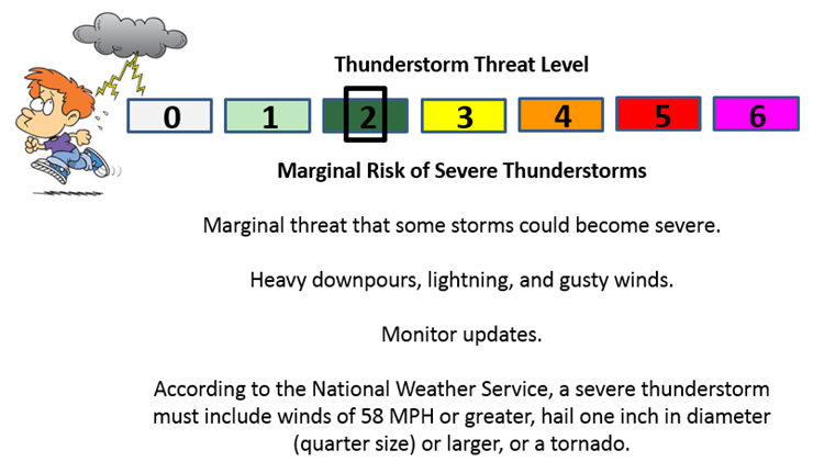
Can we expect severe thunderstorms over the next 24 to 48 hours? Remember that a severe thunderstorm is defined as a thunderstorm that produces 58 mph winds or higher, quarter size hail or larger, and/or a tornado.
The thunderstorm threat level will be a TWO for Sunday into Sunday evening. Some gusty winds possible with showers and storms.
.
Sunday and Sunday night: Some thunderstorms are possible. Gusty winds are a good bet. The risk for lightning is actual very low. But, not a zero chance.
Monday: Some storms late Sunday night still possible into early Monday morning. But, should be winding down. Gusty winds. The overall thunderstorm risk is fairly low. Meaning, lightning. But, that won’t stop gusty winds from occurring with this system.
Tuesday: Severe weather is not anticipated.
Wednesday: Severe weather is not anticipated.
Thursday: Severe weather is not anticipated.
Friday: Severe weather is not anticipated.

We have regional radars and local city radars – if a radar does not seem to be updating then try another one. Occasional browsers need their cache cleared. You may also try restarting your browser. That usually fixes the problem. Occasionally we do have a radar go down. That is why I have duplicates. Thus, if one fails then try another one.
If you have any problems then please send me an email beaudodson@usawx.com
WEATHER RADAR PAGE – Click here —
We also have a new national interactive radar – you can view that radar by clicking here.
Local interactive city radars include St Louis, Mt Vernon, Evansville, Poplar Bluff, Cape Girardeau, Marion, Paducah, Hopkinsville, Memphis, Nashville, Dyersburg, and all of eastern Kentucky – these are interactive radars. Local city radars – click here
NOTE: Occasionally you will see ground clutter on the radar (these are false echoes). Normally they show up close to the radar sites – including Paducah.


Live Lightning Data – zoom and pan: Click here
Live Lightning Data with sound (click the sound button on the left side of the page): Click here

I also set up a storm tracking page with additional links (use during active weather for quick reference)
Storm Tracking Tool Page
For watches and warnings click the image below. Then, zoom into your local area.


Here is the official 6-10 day and 8-14 day temperature and precipitation outlook. Check the date stamp at the top of each image (so you understand the time frame).
The forecast maps below are issued by the Weather Prediction Center (NOAA).


The latest 8-14 day temperature and precipitation outlook. Note the dates are at the top of the image. These maps DO NOT tell you how high or low temperatures or precipitation will be. They simply give you the probability as to whether temperatures or precipitation will be above or below normal.


Here are the current river stage forecasts. You can click your state and then the dot for your location. It will bring up the full forecast and hydrograph.
Click Here For River Stage Forecasts…

Who do you trust for your weather information and who holds them accountable?
I have studied weather in our region since the late 1970’s. I have 37 years of experience in observing our regions weather patterns. My degree is in Broadcast Meteorology from Mississippi State University and an Associate of Science (AS). I am currently working on my Bachelor’s Degree in Geoscience.
My resume includes:
Member of the American Meteorological Society.
NOAA Weather-Ready Nation Ambassador.
Meteorologist for McCracken County Emergency Management. I served from 2005 through 2015.
I own and operate the Southern Illinois Weather Observatory.
Recipient of the Mark Trail Award, WPSD Six Who Make A Difference Award, Kentucky Colonel, and the Caesar J. Fiamma” Award from the American Red Cross.
In 2009 I was presented with the Kentucky Office of Highway Safety Award.
Recognized by the Kentucky House of Representatives for my service to the State of Kentucky leading up to several winter storms and severe weather outbreaks.
I am also President of the Shadow Angel Foundation which serves portions of western Kentucky and southern Illinois.
There is a lot of noise on the internet. A lot of weather maps are posted without explanation. Over time you should learn who to trust for your weather information.
My forecast philosophy is simple and straight forward.
- Communicate in simple terms
- To be as accurate as possible within a reasonable time frame before an event
- Interact with you on Twitter, Facebook, and the blog
- Minimize the “hype” that you might see on television or through other weather sources
- Push you towards utilizing wall-to-wall LOCAL TV coverage during severe weather events
I am a recipient of the Mark Trail Award, WPSD Six Who Make A Difference Award, Kentucky Colonel, and the Caesar J. Fiamma” Award from the American Red Cross. In 2009 I was presented with the Kentucky Office of Highway Safety Award. I was recognized by the Kentucky House of Representatives for my service to the State of Kentucky leading up to several winter storms and severe weather outbreaks.
If you click on the image below you can read the Kentucky House of Representatives Resolution.

Many of my graphics are from www.weatherbell.com – a great resource for weather data, model data, and more


You can sign up for my AWARE email by clicking here I typically send out AWARE emails before severe weather, winter storms, or other active weather situations. I do not email watches or warnings. The emails are a basic “heads up” concerning incoming weather conditions.