

This forecast update covers far southern Illinois, far southeast Missouri, and far western Kentucky. See the coverage map on the right side of the blog.
Temperatures the next few days will be HIGHLY dependent on whether cloud cover thins, cloud cover remains, or if there is some clearing during the overnight hours.
The single hardest part of the forecast over the last few days have been temperatures.
Keep that in mind.
The trend, however, has always been colder than forecast. That is the one consistent theme.
Friday – Morning fog – fog could cause some patchy slick spots on roadways. Some morning sun giving way to increasing clouds. Cool. High temperatures will be in the middle to upper 40’s. Southwest winds at 5 mph.
Morning School Bus Stop Weather – Morning fog. Whatever sun there is will give way to clouds. Chilly. Temperatures at the bus stop will be in the upper 20’s and lower 30’s. Southwest winds at 5 mph
Afternoon School Bus Stop Weather – Mostly cloudy. Cool. Temperatures at the bus stop will be around 45 degrees.
Friday night – Mostly cloudy. Some patchy drizzle possible. Small chance for freezing drizzle. Overnight lows in the lower to middle 30’s. Southwest winds at 5 mph. Chance of precipitation 20%.
Saturday – A mix of sun and clouds. A bit milder, but still cool. High temperatures will be in the upper 40’s and lower 50’s. Southwest winds at 5 mph.
Saturday night – Mostly cloudy sky conditions. Perhaps some patchy fog again. Low temperatures in the upper 30’s and lower 40’s. Variable winds at 5 mph.
Sunday – A lot of clouds. Milder. High temperatures in the lower 50’s.

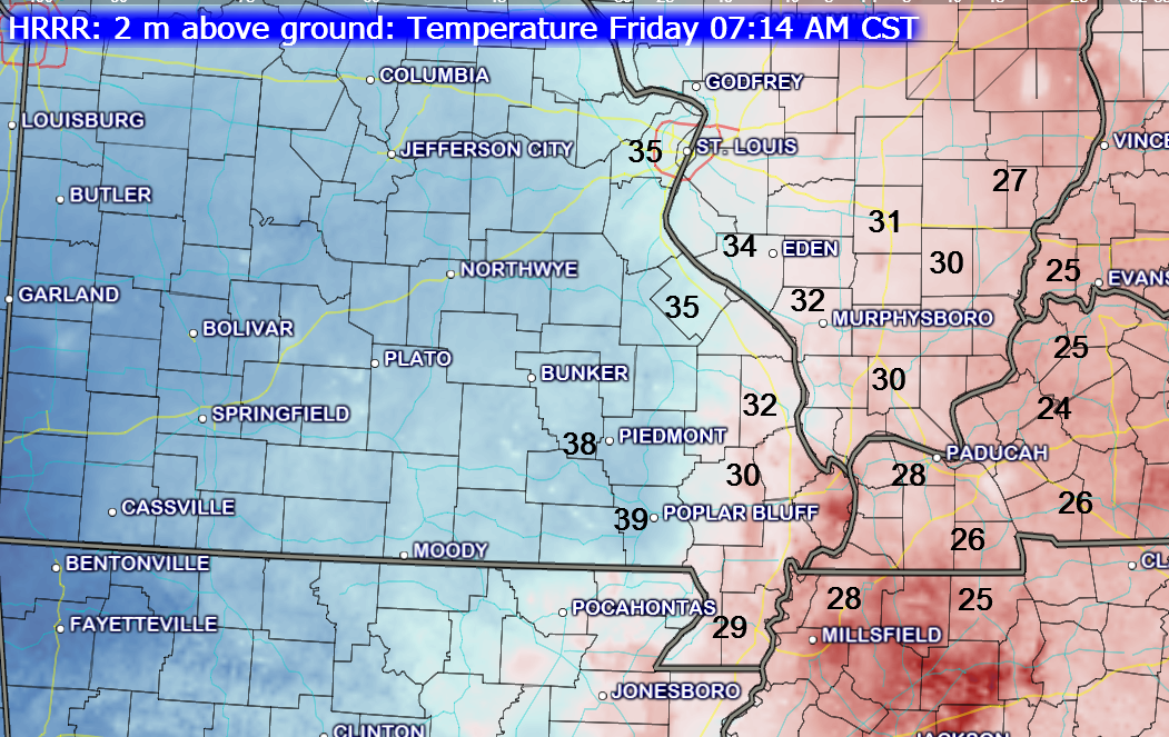
Current Temperatures Around The Local Area


An explanation of what is happening in the atmosphere over the coming days.
Welcome to the weekend! After a week of cold temperatures I wonder who is in the mood for milder air? I use the term milder loosely. 🙂 But, hey – we will take what we can get! It will still be on the cool side. So much for all those well above normal temperatures that the models were showing! Don’t trust the models – look at the pattern in general.
First things first…
Some fog this morning is causing moisture on some roadways. This could lead to a few slick spots. Use care.
We will see more clouds today into tonight. We might even see some patchy drizzle tonight. Temperatures will be in the lower to middle 30’s. If drizzle does develop and move into some of the colder spots then there could be a brief period of freezing drizzle in isolated spots.
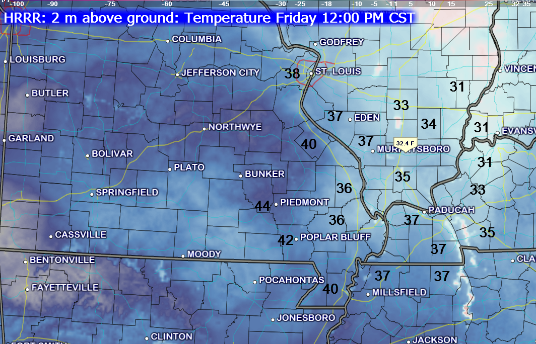
Temperatures this morning and at noon will struggle to get out of the 30’s. But, this afternoon we should see 40’s. We will have to see how these temperatures verify. Temperatures this morning were a lot colder than expected.
Time stamp at top of each image.
We should see a mix of sun and clouds on Saturday and Sunday. Temperatures will rise to the upper 40’s and lower 50’s on both Saturday and Sunday! Break out the Bermuda shorts and sun glasses. You might actually want to spend some time outside.

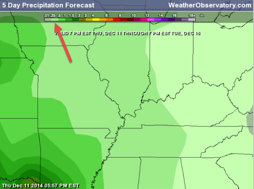
Our next rain maker arrives on late Sunday night or more like on Monday. Expect showers to spread into the area on Monday and Monday night. Rainfall totals are forecast to be on the low side. Perhaps 0.10″-0.30″. This does not look to be a big rain event.
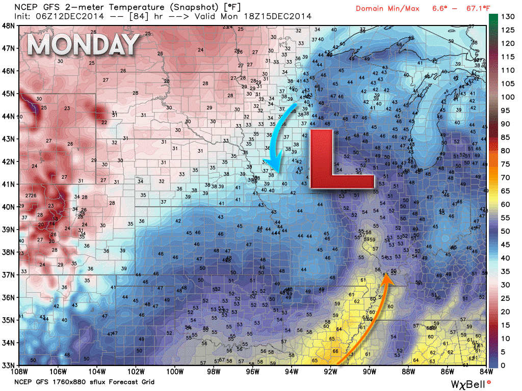
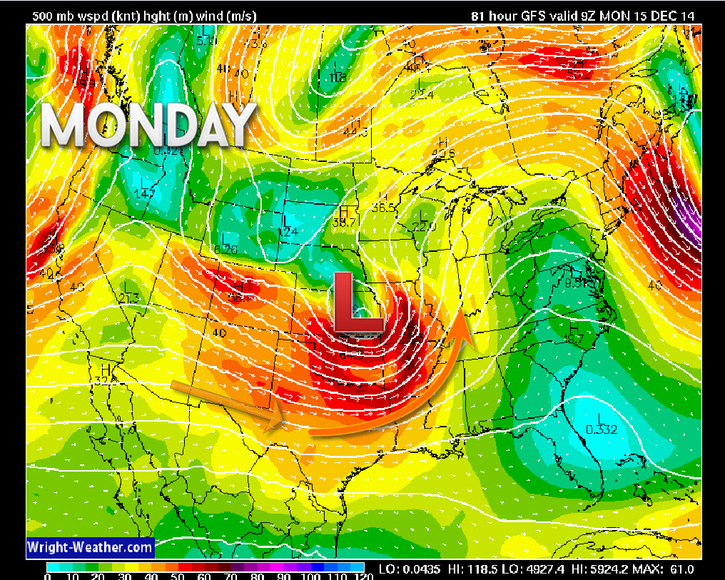
We will have a small surge of milder air push northward on Monday ahead of our cold front. Again, low pressure rotates counter-clockwise. That means if the low passes to our west or northwest that we are on the warm side of the storm. You can see that here on this temperature map for Monday. The temp scale is on the right side of the image.
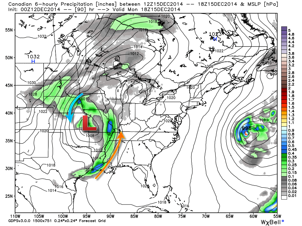
This is the Canadian weather model for Monday. You can see the area of low pressure tracking to our west/northwest. It will push northeast into MO/IL. This puts us on the warm side of the system. Remember that the area of low pressure rotates counter-clockwise. You can see the green colors representing rain. Again, not a huge rain maker by any means. But, a period or two of showers.
The black lines are equal lines of pressure. We call those isobars.
The red L would be the area of low pressure
The green represents pricipitation
The blue indicates slightly heavier precipitation (again, this is not a big rain maker)
The blue arrow indicates wind moving around the area of low pressure
The orange line represents milder air moving northward from the southern U.S.
Here is the 500 mb (18,000 feet up in the atmosphere) map for Monday – you can see the jet stream energy moving into our region. This is the steering level of the wind fields. The jet actually increases quite a bit on Monday afternoon and night.
Instability appears minimal. That will keep us from worrying about severe weather.
I am watching for the possibility of a larger storm system towards the end of next week. Still too far out for any certainties. At least something to monitor.

Added fog to the forecast – watch out for slick spots (fog causes moisture to form on roadways). I adjusted temperatures for tonight by a few degrees. Otherwise, no major changes.

Some morning fog. Fog can cause moisture to form and with cold temperatures that means the moisture could freeze on roadways. This could cause slick spots.
There is just a small chance of drizzle or perhaps even freezing drizzle during the overnight hours tonight. The chances of this appear small at any given location, but I thought I would mention it

The Wild Card gives you an idea of what might change that would cause the forecast to bust.
Wild cards in this forecast – There are a couple today!
1. Cloud cover as we push into this afternoon. Clouds should be on the increase.
2. Wild card will be the possibility of drizzle or even perhaps freezing drizzle in a few locations tonight. Overall chances appear small.

Can we expect severe thunderstorms over the next 24 to 48 hours? Remember that a severe thunderstorm is defined as a thunderstorm that produces 58 mph winds or higher, quarter size hail or larger, and/or a tornado.
Thunderstorm threat level is ZERO!


Will I need to take action?
Morning fog in some areas will cause moisture to freeze on surfaces.

Please visit your local National Weather Service Office by clicking here. The National Weather Service Office, for our region, is located in Paducah, Kentucky.

How much rain should this system produce over our region?
A light rain event is possible on Monday. Here is the latest rainfall forecast. You can see the scale at the top of the page.

No snow in the short range forecast. Once again, sorry snow fans!
I am watching a system for the end of next week and then some chances the week of Christmas. Too early for details. All I know is that we may have some precipitation makers to deal with. No thoughts on precipitation type this far out. Something for us to monitor as we move forward.

1. The weather may become active as we push towards the end of next week into the following week
2. Several systems to monitor
3. No guarantees on storm track this far out (assuming we actually do see these systems form
4. Data is very much mixed as to how everything unfolds as we push into late next week and the following.
The long range looks fairly active. But, what does that mean?
Active could mean several chances for precipitation. If storms pass to our west or northwest then milder air sweeps into the area with colder air behind each system. If storms pass to our south or over our local counties then we will see milder air for those south and east of the low pressure and colder air to the west of the systems.
Lot to watch in the long range – the pattern appears to want to move towards a more active jet stream. The weather will likely be challenging when it comes to forecasting.
If we do move towards this more active pattern then you will want to monitor updates.
The southern branch of the jet stream is likely to become active as we push into late next week. A storm system is forecast to move out of the central and southwest United States. This system may take what I call a southern track. If the area of low pressure does track to our south then it at least opens the possibility for us to be on the cold side of the system. But, that is just too far out to make a forecast.
Again, as mentioned above, if that system tracks further north then we end up on the mild side. That means rain. Time will tell. That particular system would probably impact our region around Thursday night into Saturday.
Another system may develop right behind that one.
I am also watching the week of Christmas for the possibility of a couple of precipitation makers. Again, too far out to know whether we will be cold or mild. Thus, I don’t know what type of precipitation will fall.
At least we finally have something to watch.
Many of my graphics are from www.weatherbell.com – a great resource for weather data, model data, and more


This blog was inspired by ABC 33/40’s Alabama Weather Blog – view their blog
Current tower cam view from the Weather Observatory- Click here for all cameras.

Southern Illinois Weather Observatory

The Weather Observatory

Southern Illinois Weather Observatory
WSIL TV 3 has a number of tower cameras. Click here for their tower camera page & Illinois Road Conditions

Marion, Illinois
WPSD TV 6 has a number of tower cameras. Click here for their tower camera page & Kentucky Road Conditions & Kentucky Highway and Interstate Cameras

Downtown Paducah, Kentucky
Benton, Kentucky Tower Camera – Click here for full view

Benton, Kentucky

I24 Paducah, Kentucky

I24 Mile Point 9 – Paducah, KY

You can sign up for my AWARE email by clicking here I typically send out AWARE emails before severe weather, winter storms, or other active weather situations. I do not email watches or warnings. The emails are a basic “heads up” concerning incoming weather conditions.