
We have some great sponsors for the Weather Talk Blog. Please support them when you have the opportunity.
Milner and Orr Funeral Home and Cremation Services located in Paducah, Kentucky and three other western Kentucky towns – at Milner and Orr they believe in families helping families. You can find Milner and Orr on Facebook, as well.
![]()

This forecast update covers far southern Illinois, far southeast Missouri, and far western Kentucky. See the coverage map on the right side of the blog.
Remember that weather evolves. Check back frequently for updates, especially during active weather.
The forecast numbers below may vary quite a bit across the region. These are averages.
Lower than normal confidence on the timing of precipitation over the next 5 days. Weak disturbances moving through the area could spark showers and thunderstorms from time to time. Keep this in mind.
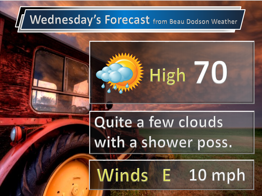
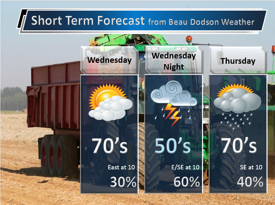
Wednesday – A mix of sun and clouds. Perhaps more clouds than sun. Coolish. A chance for a shower and even a thunderstorm. Highs in the upper 60’s to lower 70’s. East winds at 10 mph.
My confidence in this part of the forecast verifying is medium
Should I cancel my outdoor plans? Should be okay most of the day. A few showers around.
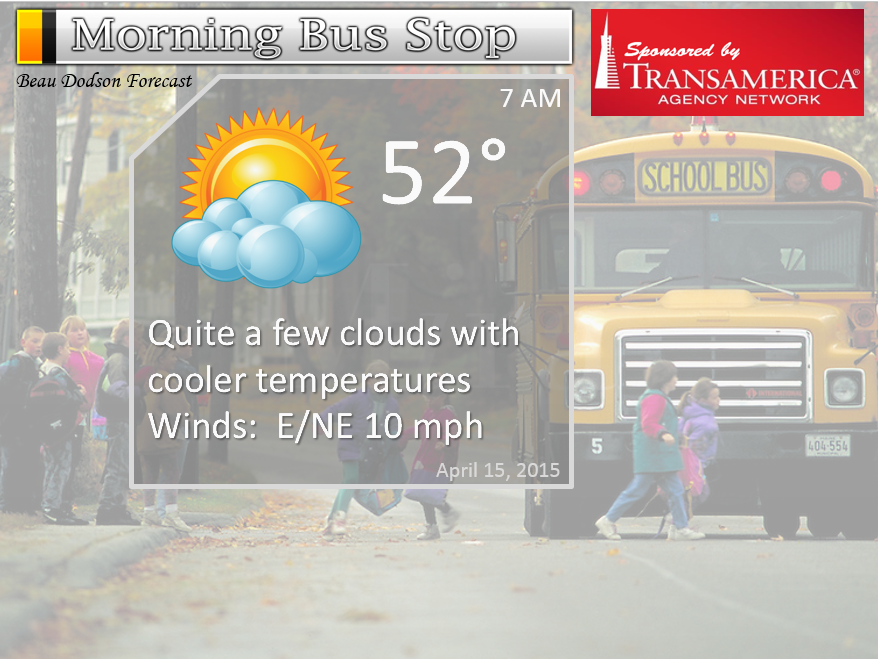
Morning School Bus Stop Weather – Some clouds. Cool. Temperatures in the middle 50’s
—————————————————————————————-
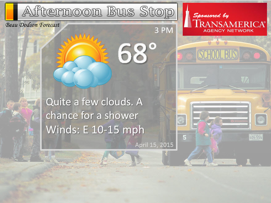
Afternoon School Bus Stop Weather – Mix of sun and clouds. Temperatures in the 68 to 72 degree range. Chance for a shower.
Wednesday night – A chance for showers and thunderstorms. Lows in the 50’s. East winds at 10 mph.
My confidence in this part of the forecast verifying is medium
Should I cancel my outdoor plans? Have a plan B
Thursday – Quite a few clouds once again. A chance for showers and thunderstorms. Highs in the 70’s with east/southeast winds at 10 mph.
My confidence in this part of the forecast verifying is medium
Should I cancel my outdoor plans? Have a plan B – monitor updates, not sure about coverage on Thursday.
Thursday night – Partly cloudy. A small chance for a shower. Lows in the upper 50’s to lower 60’s. Southeast winds at 10 mph.
My confidence in this part of the forecast verifying is medium
Should I cancel my outdoor plans? Should be okay, but monitor updates
Friday – Cloudy with a chance for showers and thunderstorms. Highs in the 70’s. South winds at 10-15 mph.
My confidence in this part of the forecast verifying is medium
Should I cancel my outdoor plans? Have a plan B

The School Bus Stop Forecast is sponsored by TransAmerica Agency Network Paducah District – you can visit their Facebook page here and their home page here
Current Temperatures Around The Local Area


Don’t forget to check out the Southern Illinois Weather Observatory web-site for weather maps, tower cams, scanner feeds, radars, and much more! Click here

An explanation of what is happening in the atmosphere over the coming days…
Highlights
1. Unsettled week. That is the theme. Trying to time precipitation chances is going to be tricky
2. Some storms possible again Wednesday night
3. Next week we might see a couple of nights with temperatures in the 30’s. Still a long way off.
The theme for the last few days has been unsettled. That theme will continue right in into the weekend. The pattern is being dominated by a system well to our west. Near the Pacific Coast. This system will slowly but surely move east over the coming days. It will stall out in the Rockies before eventually moving eastward over the weekend.
Short term forecast below…some questions on coverage of precipitation and timing right on through Thursday. Lower than normal confidence in the forecast (mainly because of timing issues with each disturbance)
Perhaps the best chance for rain/storms on Wednesday will be later in the afternoon and overnight vs earlier in the day. I would have put 40% across the board, but trying my best to give you some idea of timing.
The bottom line for Wednesday is that there could be some showers and even a thunderstorm scattered around.
What is the cause of our unsettled weather?
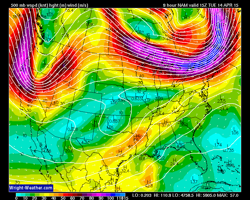
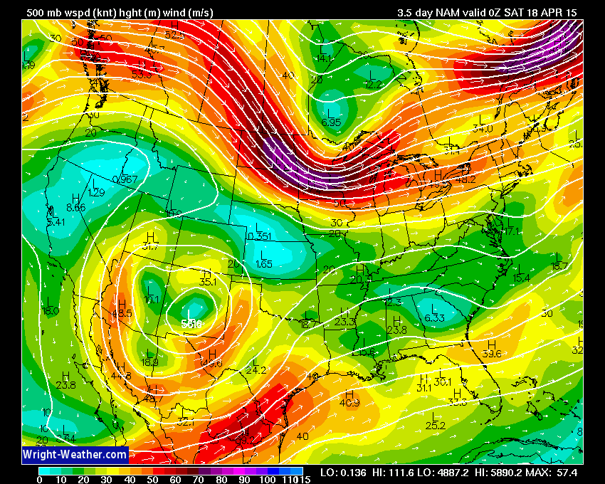
Let’s look at that system on the 500 mb upper level maps. These maps show wind speeds at 18,000 feet above the surface of the Earth. Way up there. Meteorologists use these 500 mb maps to track the jet stream and disturbances that move along with the flow of the jet stream.
See that curve U shape over the West Coast? That is the trough that will eventually move our way. Troughs are associated with unsettled weather. This is a large trough. Unfortunately, it is not in any hurry to move east.
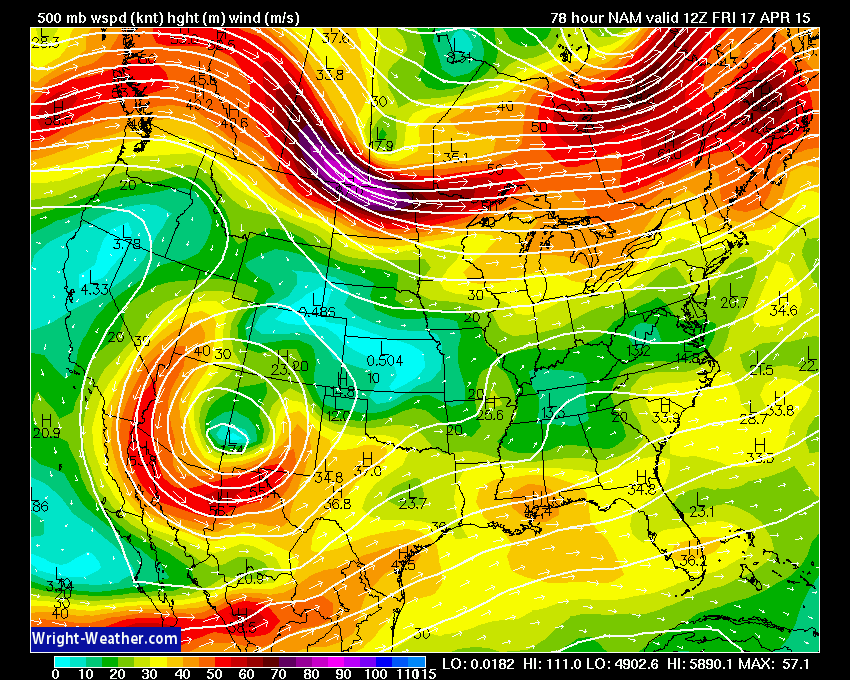
By Friday morning the upper level low is centered over southern New Mexico. See the closed lines? That is the upper level low. It is now cut-off from the jet stream to the north.
See the orange/red colors (again the colors represent wind speed – jet stream) above Oregon? Those colors ride into northern Minnesota and eventually off into Canada. That is the northern jet. Our upper level low over the southwest United States is cut-off from the jet stream. That means it won’t move very fast. It is stuck out there.
You can see the southern jet stream in Mexico nudging its way into the Gulf of Mexico. Again, notice our low is cut off from the southern jet stream, as well.
In order to nudge our cut-off low eastward we need another disturbance to move onto the West Coast. That will happen later this weekend. That disturbance should kick our upper level low eastward. When that happens we can expect shower and thunderstorm chances to increase. Likely over the weekend.
Everything in the forecast hinges on this system moving east. Some of the models keep it out there longer than other models. This does not add much confidence to timing rain and storm chances over the coming 3-5 days.
Let’s look at the Saturday 500 mb map. What has happened? Our upper level low has moved east! Good news. It is on the move.
You can see it on the Oklahoma and Texas border. As this moves east it will increase our shower and thunderstorm chances. Again, the timing is key to when the most widespread shower and thunderstorm activity will occur.
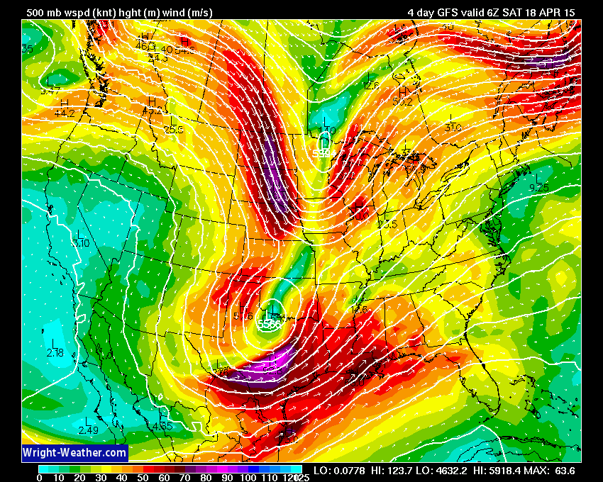
By Saturday afternoon the GFS model has the trough (that U shape in the jet stream) moving over our region. Now, with that said…the EC and some other models are slower in bringing this system east. Keep that in mind.
I think the GFS is TOO fast in bringing out the upper level low. Perhaps slow it down a bit and we have a decent idea/solution.
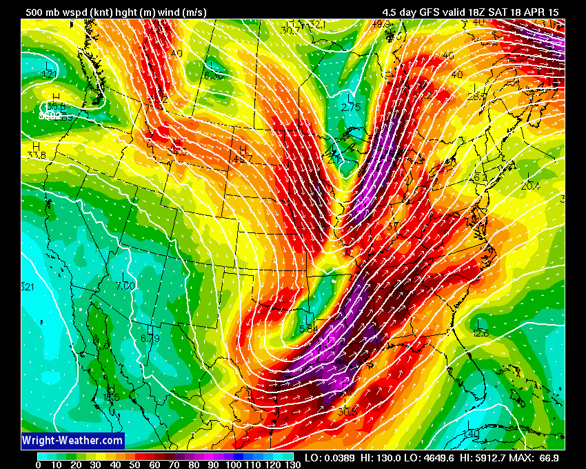
Here is the NAM model (which in this case I trust a little bit more than the GFS)
On Friday night it still has the upper level low still out in the southwest United States.
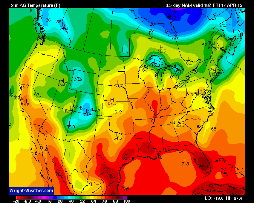
The upper level low and the position of the jet stream will help keep our region in a southerly wind flow as we push deeper into the work week. Southerly winds normally mean two things…higher temperatures and more moisture.
Let’s check the temperature chart. This is for Friday. Notice the surge of warmer air? We can think our southwest low for that. The orange colors represent 70’s and the deep orange might mean some upper 70’s to near 80 degree readings.
There is not a strong front near our region to focus precipitation. There is a frontal boundary to our south, however, and it is the focus for disturbances that will move out of the west into our region and the south-lands over the coming days. With each passing disturbance we will have a chance for some showers and thunderstorms. Severe weather is not anticipated. A little strange for the middle of April. Severe weather is near record lows for the country.
Precipitation chances?
Keep in mind that shower and thunderstorm chances will be difficult to time over the coming days.
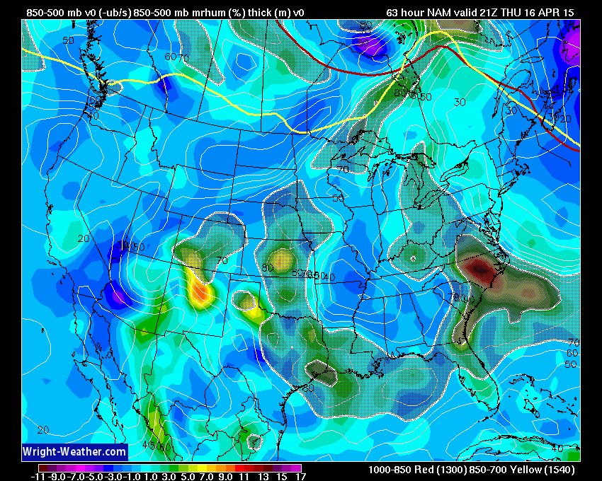
One wave will pass through our region on Wednesday afternoon and night. An area of showers and thunderstorms should form ahead of this disturbance/wave over Missouri and Arkansas. I am currently thinking Wednesday evening. It will then push east/northeast into Illinois and Kentucky.
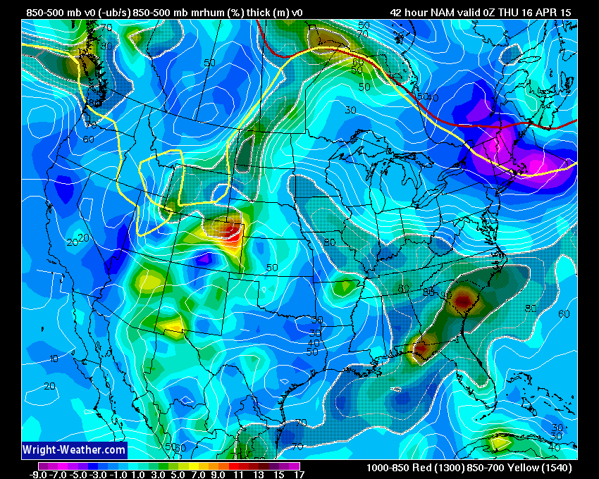
You can see that here on this chart. The hatched darker area over our region represents lift. Air rising. Thus, rain chances increase. The lift is fairly weak.
My current thinking is that a broken band of showers and storms will form on Wednesday afternoon/evening. Instability isn’t zero. But, with weak winds aloft, I think the chances for anything more than lightning and maybe gusty winds (small chance for pea size hail) is fairly small. Severe weather does not appear to be in the cards. That is the good news.
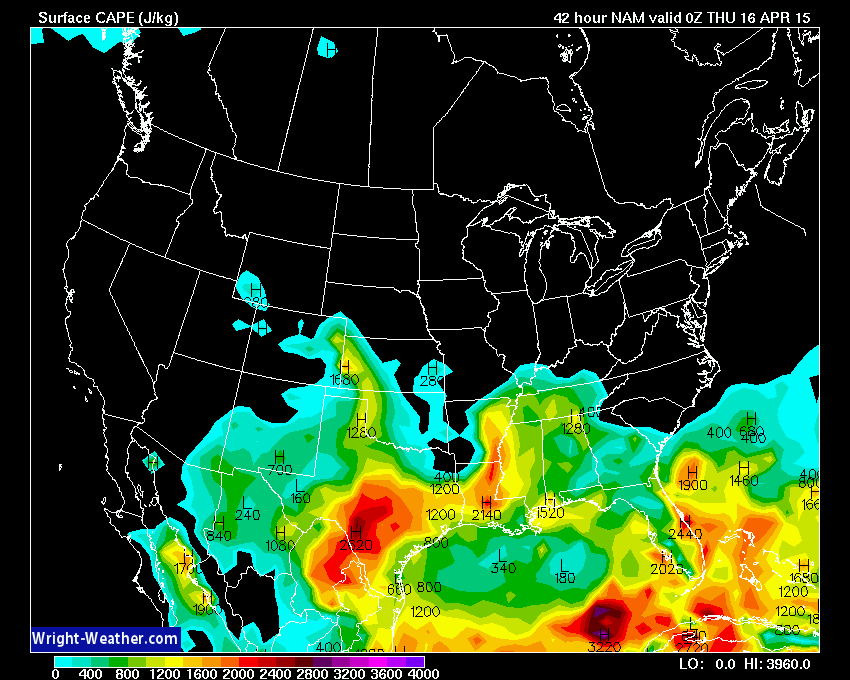
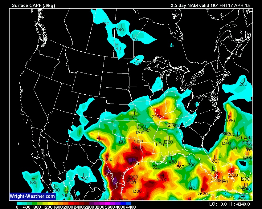
CAPE values are not overly impressive for Wednesday. But, there is some energy to work with.
What are CAPE values and what do they mean in relation to severe weather? I found a great post about CAPE values and this should explain it. For you go-getter weather enthusiasts – click here
The numbers below are low (as CAPE goes). Again, with weak wind fields aloft…I am not concerned about severe weather on Wednesday.
The bad news is that we don’t need more rain. But, more rain will likely fall over the coming days.
Again, timing each disturbance and wave is going to be tricky more than 24 hours out. I will likely keep a chance for showers and some thunderstorms in the forecast each day right on into the weekend. The whole system should move out of here by Sunday or Monday.
Let’s look at the charts that show lift, again.
This one below is for Thursday afternoon. According to this there will not be much lift on Thursday afternoon. Hopefully that will give us a little break from the rain.
There will be quite a bit of CAPE on Thursday. If there are any boundaries left around from the Wednesday night storms then a few more showers and storms could pop up. Something to keep in mind. I will monitor Thursday and Friday for a couple of storms becoming heavier.
But, let’s move ahead to Friday. A bit more organized lift enters the picture. Shower and storm chances may increase on Friday. The same is true for the weekend.
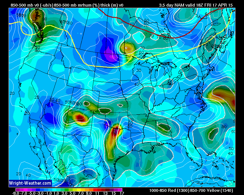
CAPE numbers on Friday are fairly high. I suppose we will have to monitor Friday for a few heavier storms. If we can get some lift into our region, that is. All of this has a lower than normal confidence level. Timing these disturbances is tricky, at best.
Let’s look at some of the future-cast precipitation charts for the coming days.
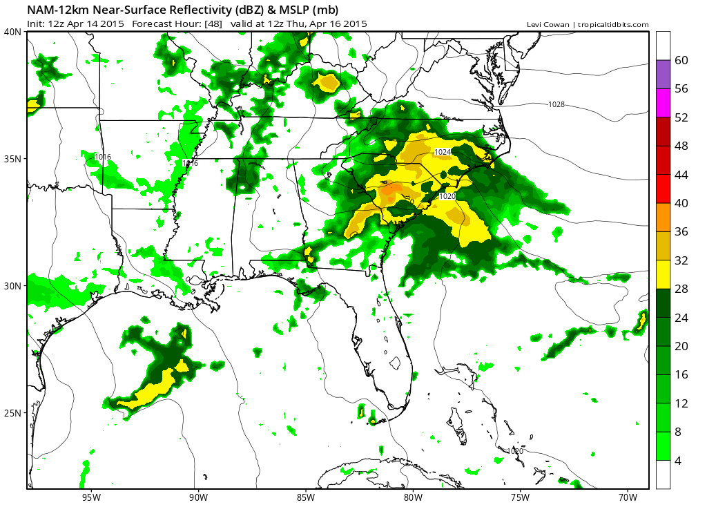
This one if for Wednesday evening. You can see some showers and storms in the area. See that line over Missouri and Arkansas? That is the line that could form and push eastward on Wednesday evening and night. We will see how it goes.
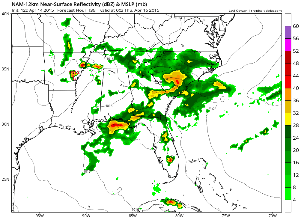
Then on Thursday morning the future-cast radar still has some showers and storms in our region. Again, lower than normal confidence on how this plays out. Weak winds aloft and weak disturbances.
If everything goes our way then Monday might be dry. See the extended forecast below for more details.
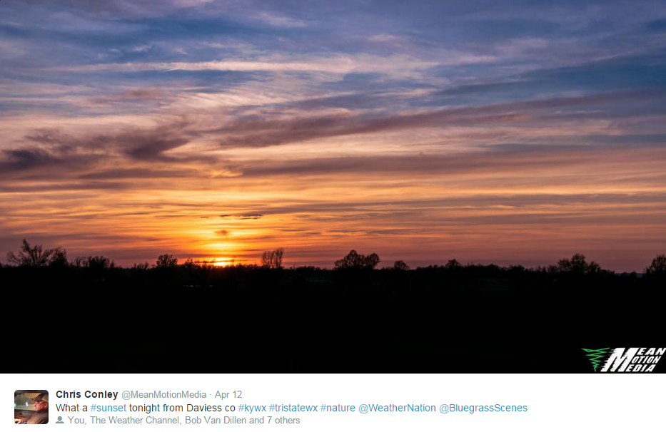
It has been awhile since I posted a nice sunset photograph.
Chris Conley took this photo. Beautiful sunset.
Radars
WEATHER RADAR PAGE – Click here —
I also set up a storm tracking page with additional links (use during active weather for quick reference)
Storm Tracking Tool Page
Have you ever attended the Charleston, Missouri Dogwood Azalea Festival? This years festival will be April 16th through the 19th. Click here for more information

Don’t forget to support our sponsors!

Updated rain chances. Otherwise, no major changes.

Some storms may form late today (Wednesday). Thinking more tonight than today. Lightning will be the main concern.
Check out our sponsors! There are more on the right side bar of the page, as well. Be sure and let them know that you appreciate their sponsorship of the WeatherTalk daily weather bulletin.
How about a $5 meal deal? The DQ Grill and Chill (located across from Noble Park in Paducah, Kentucky) is the newest WeatherTalk Blog sponsor! A local business helping to sponsor the weather information that you have come to love so much.
Check out their Facebook page for specials, as well DQ Grill and Chill on Facebook


Premier Portable Buildings proudly serving our region. For more information click the above ad or here
They can also be found on this Facebook page
G&C Multi-Services out of Paducah, Kentucky. G & C Multi-Services is a service provider in Western Kentucky that provides industrial and commercial equipment fabrication, machine troubleshooting, repair and maintenance, and installation. They can custom fabricate steel, stainless, and aluminum products per customer specifications.
Visit their web-site here. Or click the ad below! Facebook page.


Wortham Dental Care located in Paducah, Kentucky. The gentle dentist. Mercury free dentistry. They also do safe Mercury removal. You can find Wortham Dental Care on Facebook, as well

Trover’s Equipment and Lawn Care – Family owned and operated! They are a dealer for Snapper, Simplicity, Snapper Pro, Bad Boy Mowers, and Intimidator Utility Vehicles. They are a Stihl and Dolmar power products dealer. They also are a dealer for Briggs & Stratton, Kohler gas & diesel engines, and Kawasaki engines. They service and repair just about any brand. You can find them on Facebook, as well

Visit their web-site here. Or, you can also visit their Facebook page.

Endrizzi’s Storm Shelters – For more information click here. Endrizzi Contracting and Landscaping can be found on Facebook, as well – click here

Gary Eckelkamp’s web-site click the above banner or click here
.

Here are the current river stage forecasts. You can click your state and then the dot for your location. It will bring up the full forecast and hydrograph.
Click Here For River Stage Forecasts…
Here are some current forecast hydrographs. These will be updated each day with new information.


Smithland Lock and Dam

Paducah, Kentucky Forecast Stage

Cairo, Illinois

A couple of showers possible today. Better chance Wednesday night. Umbrella might be needed if storms do develop. Lightning is the only concern.

The wild card tells you where the uncertainties are in the forecast
Wild card in this forecast – Coverage of precipitation late Wednesday and Wednesday night as a disturbance moves through the region. Low confidence on the forecast. I do believe some showers and thunderstorms will form along this disturbance and move across our region from west/southwest to northeast.

Can we expect severe thunderstorms over the next 24 to 48 hours? Remember that a severe thunderstorm is defined as a thunderstorm that produces 58 mph winds or higher, quarter size hail or larger, and/or a tornado.
Thunderstorm threat level is ONE. Some storms are possible on Wednesday night.
Thursday Severe Weather Outlook – Severe weather is not anticipated (thunder possible)
Friday Severe Weather Outlook – Severe weather is not anticipated (thunder possible)
Saturday Severe Weather Outlook – Severe weather is not anticipated (thunder possible)
Sunday Severe Weather Outlook – Severe weather is not anticipated (thunder possible)


How much precipitation should we expect over the next few days?
Rainfall totals between now and April 27th could total in the inches. Some areas already picked up 1-3″ of rain on Monday and Monday night. Additional rain will not be appreciated.
We will have on and off rain chances in Friday night. Then another widespread rain/storm event occurs on Saturday or Sunday. Still some timing issues. I suspect that between now and Sunday night the area will pick up 1-2″ of rain. Locally heavier totals likely.
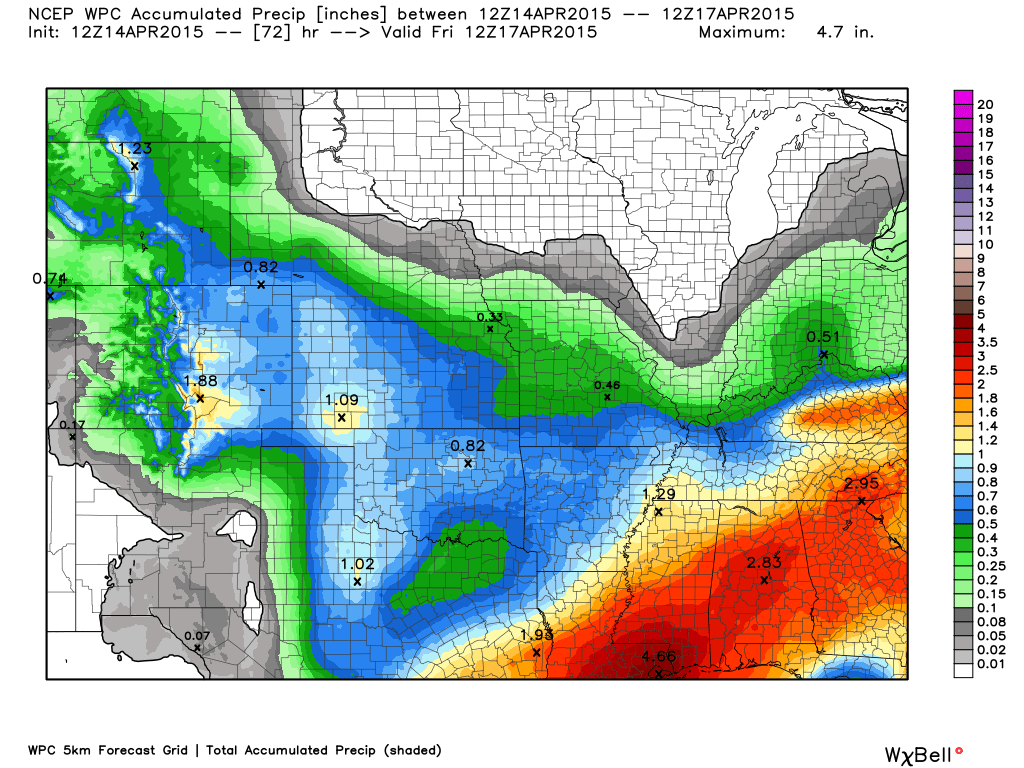
This first graphic from weatherbell.com shows you the expected rainfall totals through Friday morning
Click for larger view
This second graphic shows you the rainfall totals from now through next Monday evening
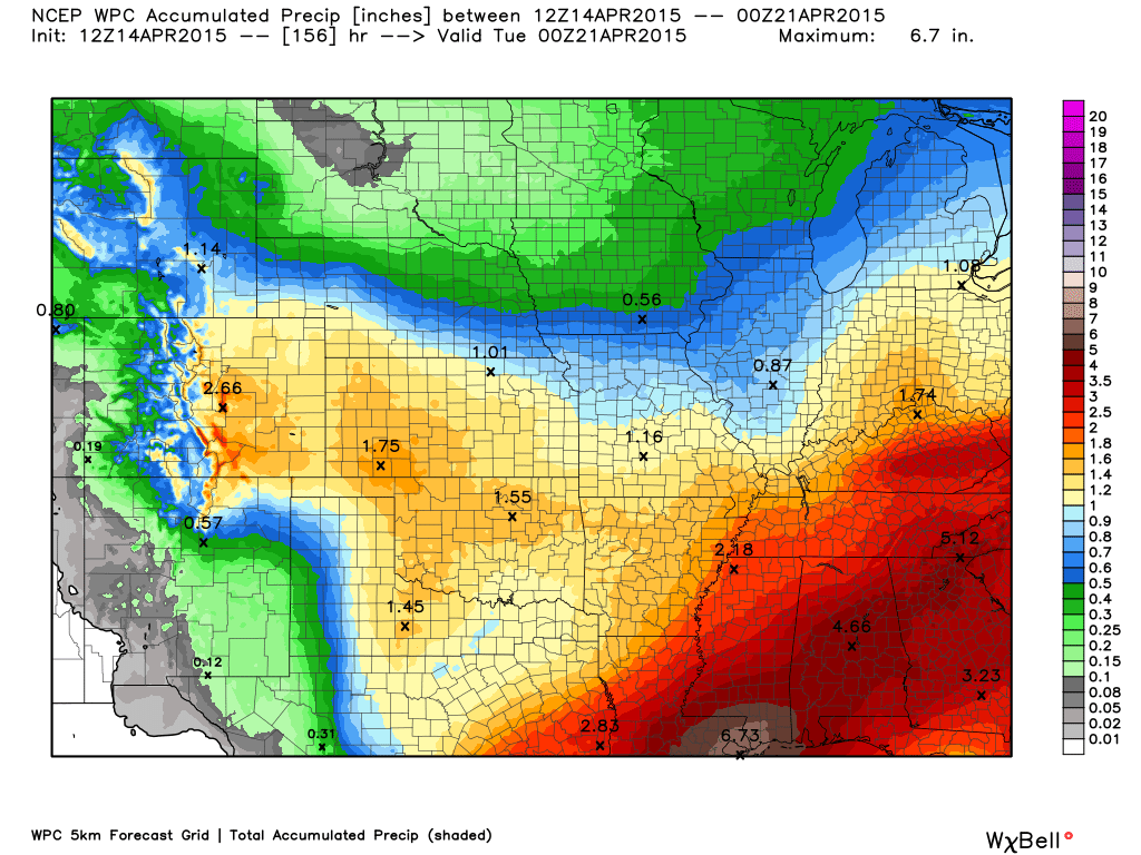
As always, locally heavy rain can occur with thunderstorms. Keep that in mind.

This section of the blog is speculative forecast information. Because it is past the range of what meteorologists can forecast accurately, it should be considered speculation. Anything past day 5 is considered a long range forecast.
Well, I went into quite a bit of detail about what is going to happen through the weekend.
The main concern over the weekend is the timing of our big upper level low over the southwest…moving east. When it moves east we will see widespread showers and thunderstorms develop over our region.
Right now it appears the best chance for showers and storms will be somewhere in the Saturday night to Sunday night time frame. I can’t rule out a few strong storms. Not sure about severe weather, just yet. Monitor updates.
The GFS is a bit faster with this system than some of the other models. GFS is one model that meteorologists use to monitor the forecast. I am not sure the GFS is on the right track, but let’s look at the rain maps it is spitting out
This is for Saturday morning (again, this is the GFS model). You can see widespread rain over our region. The GFS is assuming that the big upper level low kicks out of the southwest and moves through our region. IF that happens then yes…we would have a lot of rain around
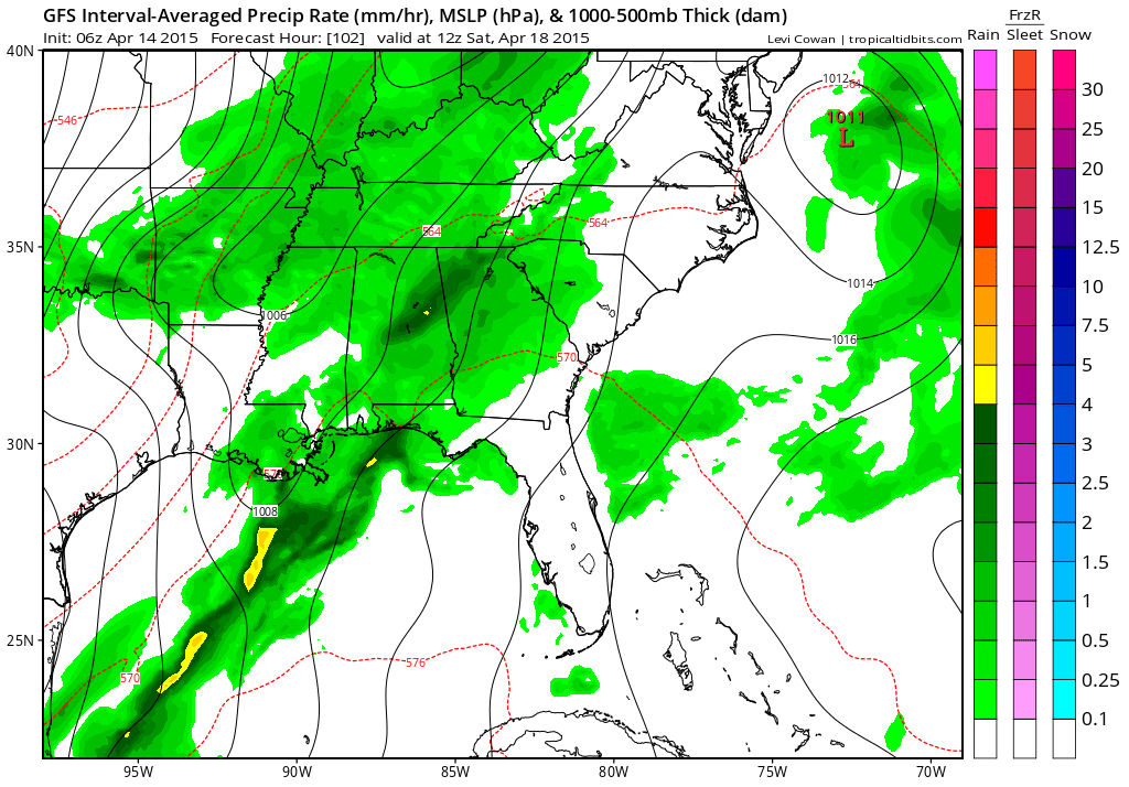
By Sunday the GFS has moved everything east.

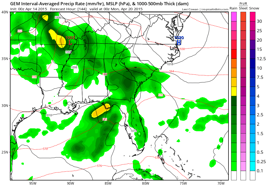
The Canadian model, on the other hand, brings the system into our region on Sunday. It has support from some other models, as well. I am leaning towards Saturday night into Sunday night for the best rain and storm chances (with the upper level low moving out)
This is the Canadian model below. Green represents rain. Yellow is heavier rain. The Canadian model even has a low passing into southeast Missouri. We will need to monitor Saturday night into Sunday night for some heavier storms.
All in all…low confidence on the timing of precipitation. I am going to put rain chances in the forecast each day…right on into Sunday. Keep that in mind.
Next week we should have a couple of dry days. Hopefully Monday and Tuesday. Another cold front may arrive around Wednesday. Colder air will be possible next week. Some data even indicates 30’s.
A larger storm system may approach next weekend. Long way off for details.
Can you believe May will be here soon? Zoom zoom

We have regional radars and local city radars – if a radar does not seem to be updating then try another one. Occasional browsers need their cache cleared. You may also try restarting your browser. That usually fixes the problem. Occasionally we do have a radar go down. That is why I have duplicates. Thus, if one fails then try another one.
If you have any problems then please send me an email beaudodson@usawx.com
WEATHER RADAR PAGE – Click here —
We also have a new national interactive radar – you can view that radar by clicking here.
Local interactive city radars include St Louis, Mt Vernon, Evansville, Poplar Bluff, Cape Girardeau, Marion, Paducah, Hopkinsville, Memphis, Nashville, Dyersburg, and all of eastern Kentucky – these are interactive radars. Local city radars – click here
NOTE: Occasionally you will see ground clutter on the radar (these are false echoes). Normally they show up close to the radar sites – including Paducah.

Regional Radar – Click on radar to take you our full radar page.


Regional Radar

Live Lightning Data – zoom and pan: Click here
Live Lightning Data with sound (click the sound button on the left side of the page): Click here
![]()
Current WARNINGS (a warning means take action now). Click on your county to drill down to the latest warning information. Keep in mind that there can be a 2-3 minute delay in the updated warning information.
I strongly encourage you to use a NOAA Weather Radio or warning cell phone app for the most up to date warning information. Nothing is faster than a NOAA weather radio.


Color shaded counties are under some type of watch, warning, advisory, or special weather statement. Click your county to view the latest information.

Missouri Warnings

Illinois Warnings

Kentucky Warnings

Please visit your local National Weather Service Office by clicking here. The National Weather Service Office, for our region, is located in Paducah, Kentucky. They have a lot of maps and information on their site. Local people…local forecasters who care about our region.

Here is the official 6-10 day and 8-14 day temperature and precipitation outlook. Check the date stamp at the top of each image (so you understand the time frame).
The forecast maps below are issued by the Weather Prediction Center (NOAA).


The latest 8-14 day temperature and precipitation outlook. Note the dates are at the top of the image. These maps DO NOT tell you how high or low temperatures or precipitation will be. They simply give you the probability as to whether temperatures or precipitation will be above or below normal.


Who do you trust for your weather information and who holds them accountable?
I have studied weather in our region since the late 1970’s. I have 37 years of experience in observing our regions weather patterns. My degree is in Broadcast Meteorology from Mississippi State University and an Associate of Science (AS). I am currently working on my Bachelor’s Degree in Geoscience. Just need to finish two Spanish classes!
I am a member of the American Meteorological Society. I am a NOAA Weather-Ready Nation Ambassador. And, I am the Meteorologist for McCracken County Emergency Management.
I own and operate the Southern Illinois Weather Observatory.
There is a lot of noise on the internet. A lot of weather maps are posted without explanation. Over time you should learn who to trust for your weather information.
My forecast philosophy is simple and straight forward.
- Communicate in simple terms
- To be as accurate as possible within a reasonable time frame before an event
- Interact with you on Twitter, Facebook, and the blog
- Minimize the “hype” that you might see on television or through other weather sources
- Push you towards utilizing wall-to-wall LOCAL TV coverage during severe weather events
I am a recipient of the Mark Trail Award, WPSD Six Who Make A Difference Award, Kentucky Colonel, and the Caesar J. Fiamma” Award from the American Red Cross. In 2009 I was presented with the Kentucky Office of Highway Safety Award. I was recognized by the Kentucky House of Representatives for my service to the State of Kentucky leading up to several winter storms and severe weather outbreaks.
If you click on the image below you can read the Kentucky House of Representatives Resolution.

I am also President of the Shadow Angel Foundation which serves portions of western Kentucky and southern Illinois.
Many of my graphics are from www.weatherbell.com – a great resource for weather data, model data, and more


This blog was inspired by ABC 33/40’s Alabama Weather Blog – view their blog
Current tower cam view from the Weather Observatory- Click here for all cameras.

Southern Illinois Weather Observatory

The Weather Observatory

Southern Illinois Weather Observatory
WSIL TV 3 has a number of tower cameras. Click here for their tower camera page & Illinois Road Conditions

Marion, Illinois
WPSD TV 6 has a number of tower cameras. Click here for their tower camera page & Kentucky Road Conditions & Kentucky Highway and Interstate Cameras

Downtown Paducah, Kentucky
Benton, Kentucky Tower Camera – Click here for full view

Benton, Kentucky

I24 Paducah, Kentucky

I24 Mile Point 9 – Paducah, KY

I24 – Mile Point 3 Paducah, Kentucky

You can sign up for my AWARE email by clicking here I typically send out AWARE emails before severe weather, winter storms, or other active weather situations. I do not email watches or warnings. The emails are a basic “heads up” concerning incoming weather conditions.