We have some great sponsors for the Weather Talk Blog. Please support them when you have the opportunity.
Milner and Orr Funeral Home and Cremation Services located in Paducah, Kentucky and three other western Kentucky towns – at Milner and Orr they believe in families helping families. You can find Milner and Orr on Facebook, as well.
![]()

This forecast update covers far southern Illinois, far southeast Missouri, and far western Kentucky. See the coverage map on the right side of the blog.
Remember that weather evolves. Check back frequently for updates, especially during active weather.
The forecast numbers below may vary quite a bit across the region. These are averages.
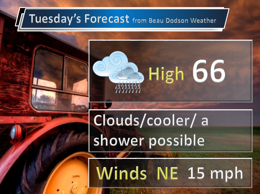
Tuesday – A mix of sun and clouds later today. Just a small chance for a remaining shower or two. It will be cooler than it was on Monday. Breezy at times. Highs mostly in the 60’s (perhaps a few lower 70’s if the sun can pop out). North and northeast winds at 10-15 mph with a gust to 20 mph possible. My confidence in this part of the forecast verifying is high
Should I cancel my outdoor plans? Damp grounds from recent rain. Otherwise, small shower chance.
Morning School Bus Stop Weather – Cooler. Some clouds and a few showers around the area. Cooler. Temperatures starting out in the 50’s.
—————————————————————————————-
Afternoon School Bus Stop Weather – Mix of sun and clouds. Maybe a few showers lingering. Temperatures only in the 60’s.
Tuesday night – Mostly cloudy and chilly. Lows into the 40’s and lower 50’s over most of our counties. East and northeast winds at 5-10 mph. My confidence in this part of the forecast verifying is high
Should I cancel my outdoor plans? Should not have any problems outside.
Wednesday – Partly cloudy. A stray shower or storm possible. Cool. Highs mainly in the 60’s. East and northeast winds at 5-10 mph. My confidence in this part of the forecast verifying is medium
Should I cancel my outdoor plans? Small chance for a scattered shower or storm.
Wednesday night – Increasing clouds. Showers and thunderstorms possible. Not quite as cool. Lows in the 50’s. East winds at 10 mph. My confidence in this part of the forecast verifying is medium
Should I cancel my outdoor plans? Should be okay. I can’t rule out a scattered shower.
Thursday – Mostly cloudy with a chance for a shower or thunderstorm. A little warmer. Highs from 68 to 74 degrees. East and southeast winds at 5-10 mph. My confidence in this part of the forecast verifying is medium
Should I cancel my outdoor plans? I can’t rule out a shower or storm

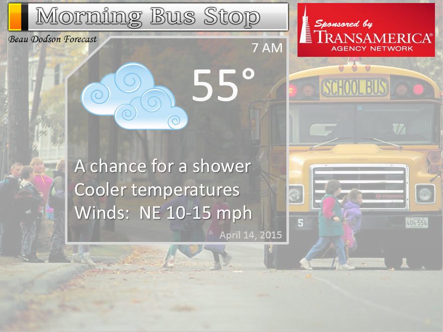
The School Bus Stop Forecast is sponsored by Transamerica Agency Network Paducah District – you can visit their Facebook page here and their home page here

Current Temperatures Around The Local Area


Don’t forget to check out the Southern Illinois Weather Observatory web-site for weather maps, tower cams, scanner feeds, radars, and much more! Click here

An explanation of what is happening in the atmosphere over the coming days…
Highlights
1. Showers coming to an end today.
2. Cool Tuesday night.
3. Severe weather is off to a very slow start this year. Something to be thankful for!
4. Low confidence in the extended outlook
Messy weather pattern for the rest of the week, and not a clear cut forecast.
Showers and some thunderstorms spread into the region on Monday. Some locally heavy downpours, as well. Nothing of the severe nature. We can be thankful for that. It is the middle of April.
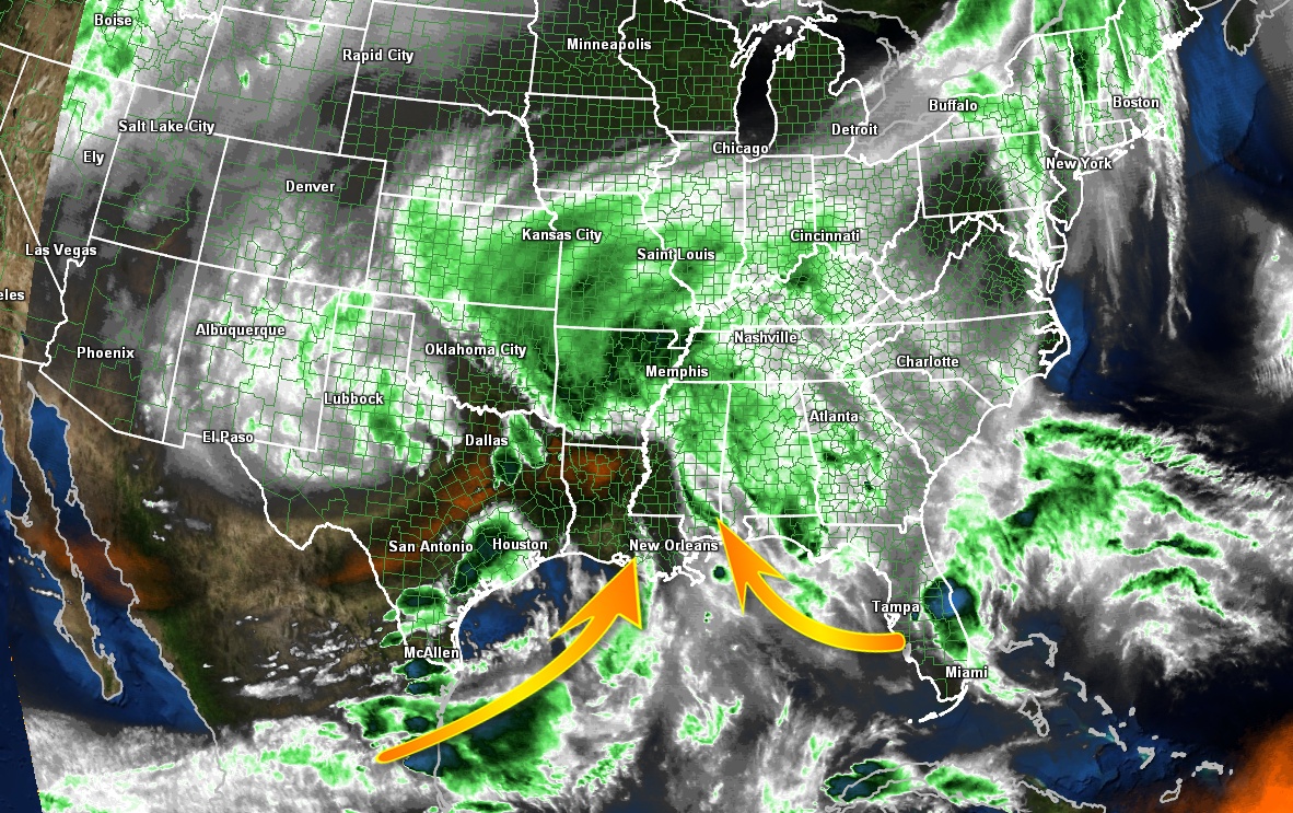
Check out the water vapor satellite view of our rain system. Moisture spreading in from the Gulf of Mexico and the Pacific Ocean
Monday evening view of the rain system.
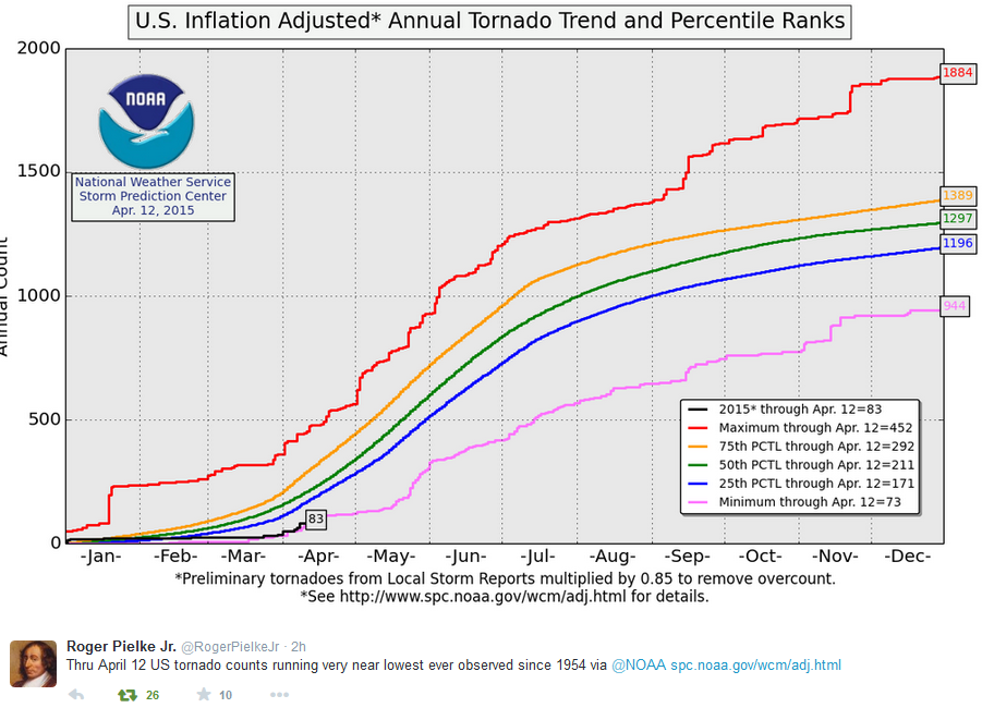
Severe weather over the past month has been extremely quiet around the nation. A few events, but nothing like a normal year. Of course norms are made up of extremes. Extremely quiet and extremely active.
As a matter of fact, the tornado count is running the lowest it has been since 1954! Click image for a larger view.
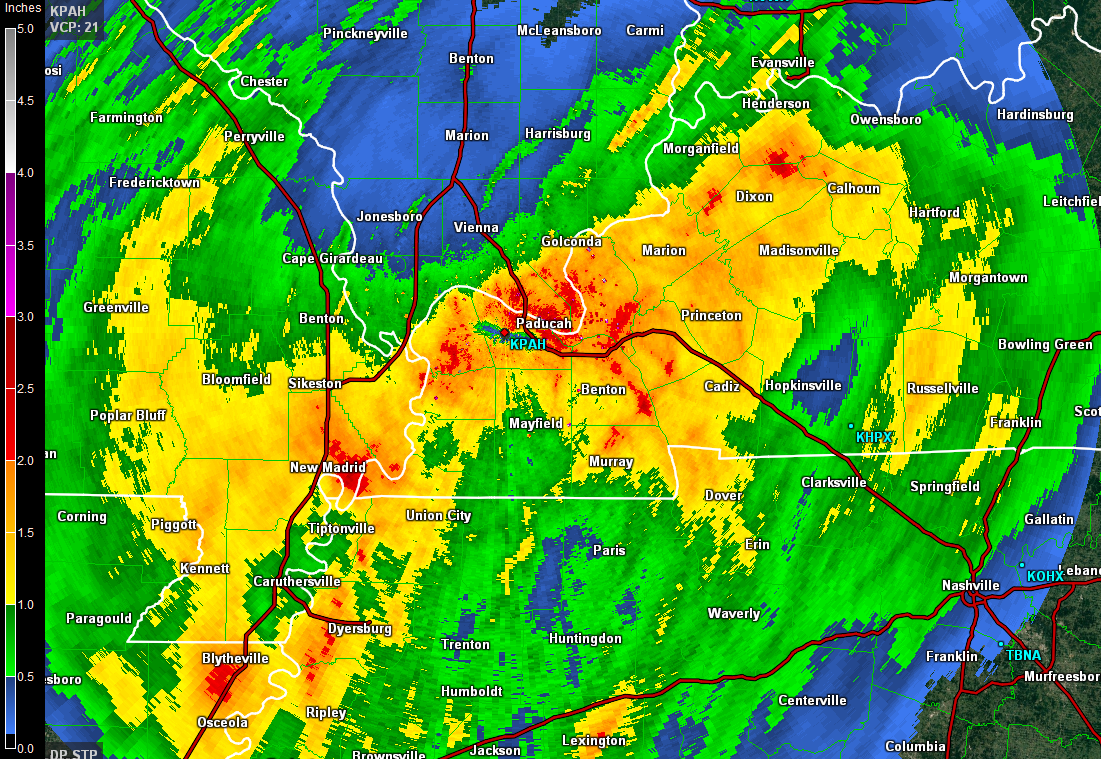
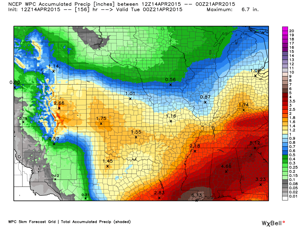
Quite a bit of rain fell over the region on Monday into Tuesday morning. Heaviest totals were over the southern half of the region. Not as much over the northern half.
Rainfall totals as estimated by radar – click for larger view

We will have some gusty winds on Monday night and Tuesday. Nothing significant, but some gusts above 20 mph are in my forecast.
Our winds will pick up because of the difference in air pressure between the high pressure moving in and the low pressure moving out. These lines of equal pressure are called isobars. When the isobars are close together our wind speeds increase.
I drew them on this map in red, so you could see them better. These are the isobars for later tonight. Again, nothing major. But, just wanted to show you why the winds increase.
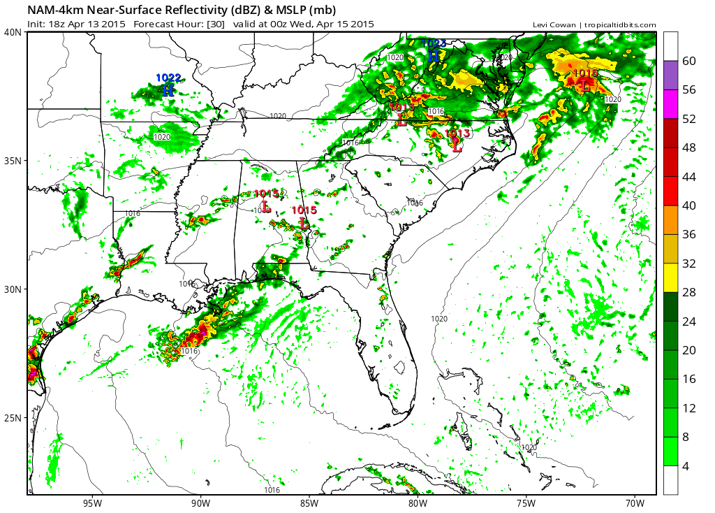
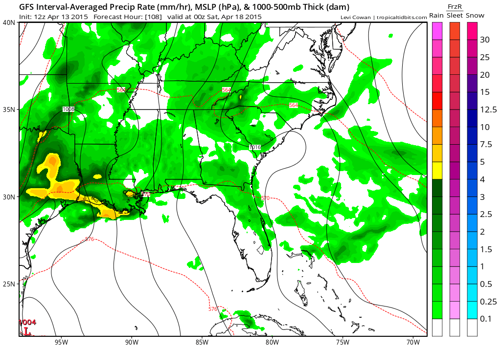
Rain will continue into Monday night and early Tuesday morning. The rain will end from NW to SE. That means our eastern and southeastern counties will have rain the longer (see the future-cast radar view below for 3 am Tuesday morning – lot of rain over west KY)
We will have clouds and rain showers on Tuesday morning. Then a mix of sun and clouds with a scattered rain shower possible during the afternoon.
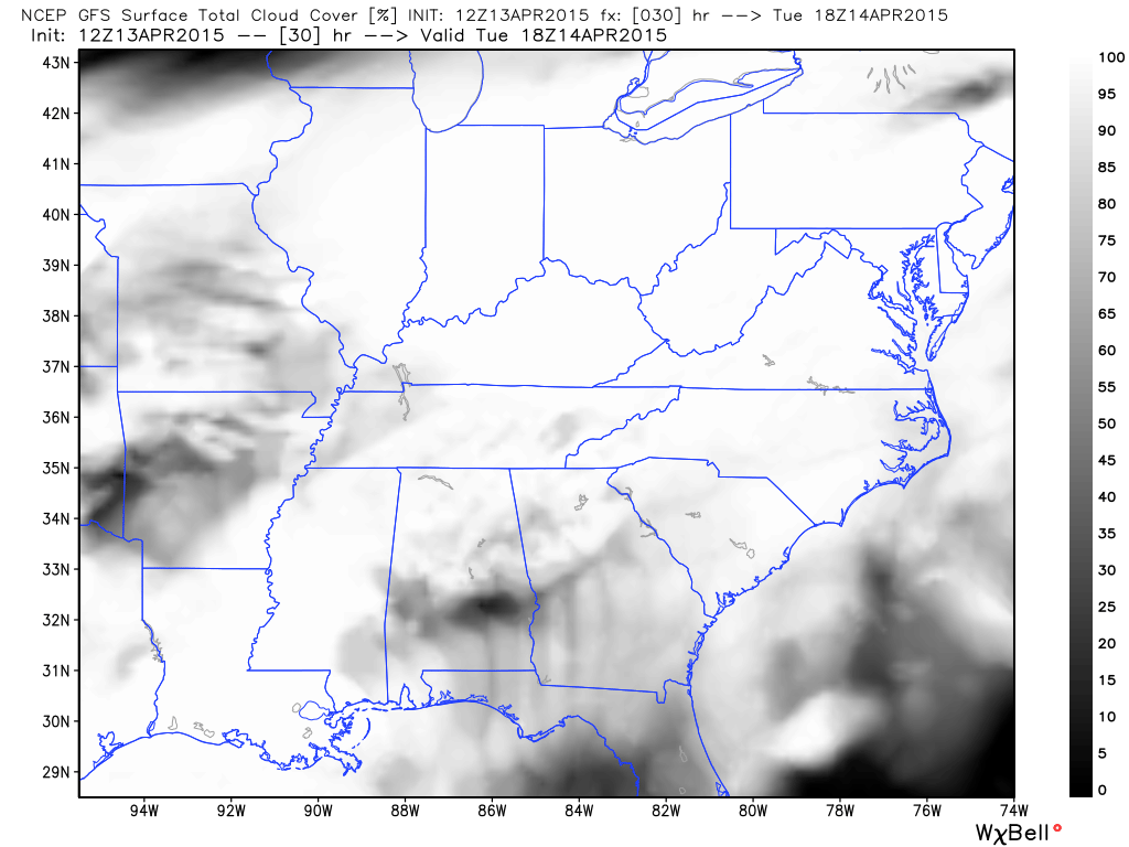
GFS model future-cast satellite is showing a lot of clouds in the region. Image from weatherbell.com
The white area represents clouds.
Tuesday won’t be like Monday. The nature of the precipitation will be much more scattered. Not nearly as heavy. As a matter of fact, some places may not see any measurable rainfall on Tuesday.
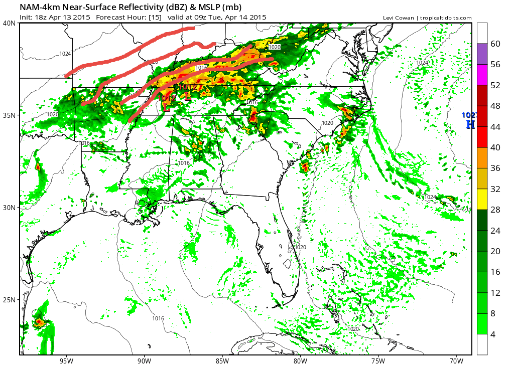
Here is the future-cast radar from the NAM model. You can see some patches of green in our area. Those are scattered rain showers.
The 10 am radar view. Few patches of rain around.
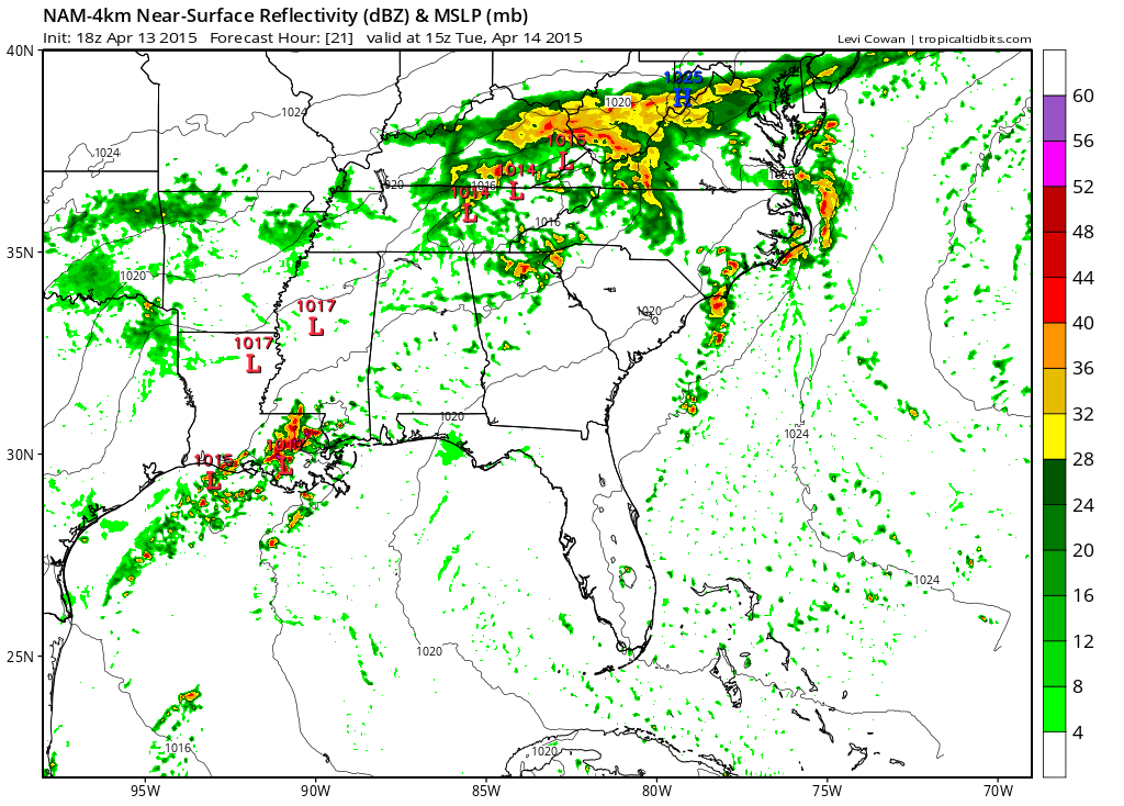
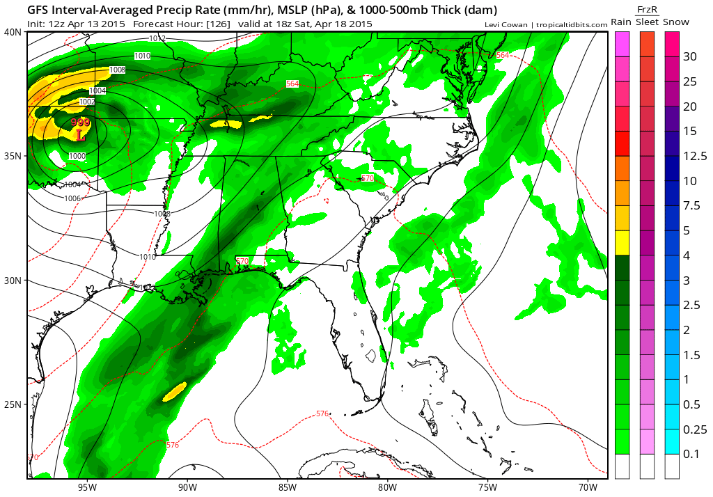
The mid-afternoon future-cast radar. Still some patches of light rain around.
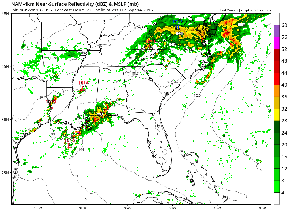
And finally, the evening future-cast radar. I would not key in on the exact location of a patch of green. Just know that a few scattered showers are possible.
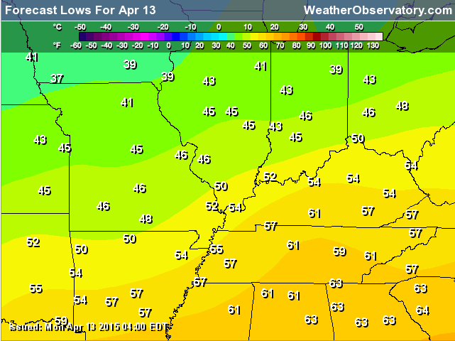
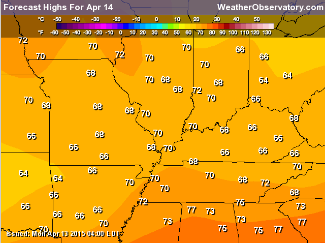
It will be cooler on Tuesday, as well. Highs on Tuesday won’t get out of the 60’s over much of the area. A few spots could hit 70.
Tuesday morning lows. Upper 40’s to lower 50’s over the area.
Afternoon highs
Showers and thunderstorm chances will increase a bit as we head into Wednesday evening and Thursday.
A muddled forecast as we move into the late part of the week. See the extended for details.
Radars
WEATHER RADAR PAGE – Click here —
I also set up a storm tracking page with additional links (use during active weather for quick reference)
Storm Tracking Tool Page
Have you ever attended the Charleston, Missouri Dogwood Azalea Festival? This years festival will be April 16th through the 19th. Click here for more information

Don’t forget to support our sponsors!

Updated temperatures and wind. No major changes to the forecast. Will need to monitor Wednesday onward for changes. Low confidence in the extended forecast.

No major concerns for Tuesday! A lingering shower here and there.
Check out our sponsors! There are more on the right side bar of the page, as well. Be sure and let them know that you appreciate their sponsorship of the WeatherTalk daily weather bulletin.
How about a $5 meal deal? The DQ Grill and Chill (located across from Noble Park in Paducah, Kentucky) is the newest WeatherTalk Blog sponsor! A local business helping to sponsor the weather information that you have come to love so much.
Check out their Facebook page for specials, as well DQ Grill and Chill on Facebook


Premier Portable Buildings proudly serving our region. For more information click the above ad or here
They can also be found on this Facebook page
G&C Multi-Services out of Paducah, Kentucky. G & C Multi-Services is a service provider in Western Kentucky that provides industrial and commercial equipment fabrication, machine troubleshooting, repair and maintenance, and installation. They can custom fabricate steel, stainless, and aluminum products per customer specifications.
Visit their web-site here. Or click the ad below! Facebook page.


Wortham Dental Care located in Paducah, Kentucky. The gentle dentist. Mercury free dentistry. They also do safe Mercury removal. You can find Wortham Dental Care on Facebook, as well

Trover’s Equipment and Lawn Care – Family owned and operated! They are a dealer for Snapper, Simplicity, Snapper Pro, Bad Boy Mowers, and Intimidator Utility Vehicles. They are a Stihl and Dolmar power products dealer. They also are a dealer for Briggs & Stratton, Kohler gas & diesel engines, and Kawasaki engines. They service and repair just about any brand. You can find them on Facebook, as well

Visit their web-site here. Or, you can also visit their Facebook page.

Endrizzi’s Storm Shelters – For more information click here. Endrizzi Contracting and Landscaping can be found on Facebook, as well – click here

Gary Eckelkamp’s web-site click the above banner or click here
.

Here are the current river stage forecasts. You can click your state and then the dot for your location. It will bring up the full forecast and hydrograph.
Rivers are starting to level off again and will soon start to fall. This is good news. If we can keep the heavy rains away, then maybe we can get a steady fall over the coming 1-2 weeks.
It is that time of the year to monitor forecasts closely. It only takes one stalled front to cause major problems. That was supposed to happen this week. Thankfully the charts changed.
Click Here For River Stage Forecasts…
Here are some current forecast hydrographs. These will be updated each day with new information.


Smithland Lock and Dam

Paducah, Kentucky Forecast Stage

Cairo, Illinois

Perhaps an umbrella will be needed in a few spots. Jacket weather perhaps. Cooler today.

The wild card tells you where the uncertainties are in the forecast
Wild card in this forecast – The wild card today is going to be the coverage of showers that remain in the area. I don’t believe everyone will experience a shower today. But, a few will certainly be scattered around on radar.

Can we expect severe thunderstorms over the next 24 to 48 hours? Remember that a severe thunderstorm is defined as a thunderstorm that produces 58 mph winds or higher, quarter size hail or larger, and/or a tornado.
Thunderstorm threat level is ZERO/ONE. Some showers will remain in the area today. I think the risk for lightning is small. But, I will include a ONE just in case there is a rumble of thunder. Today will mainly be a few showers.
Wednesday Severe Weather Outlook – A rumble of thunder possible
Thursday Severe Weather Outlook – A rumble of thunder possible
Friday Severe Weather Outlook – A rumble of thunder possible
Saturday Severe Weather Outlook – Monitor updates – maybe some thunder.
Sunday Severe Weather Outlook – Severe weather is not currently anticipated.


How much precipitation should we expect over the next few days?
Additional on and off rain chances will be possible as we move into Wednesday-Saturday. Some of the data indicates another round or two of heavier rain. Confidence is not great, at this time, in the eventual outcome.
Perhaps the next best shot of rain will be Wednesday evening and then again on Friday. That is how the charts are painting it.
Rainfall between now and Monday. There could be some locally heavy rain

This section of the blog is speculative forecast information. Because it is past the range of what meteorologists can forecast accurately, it should be considered speculation. Anything past day 5 is considered a long range forecast.
Unsettled weather is likely going to stick around into at least the end of the week. Some of the charts even show it going into the weekend.
The data is mixed on whether or not to bring an upper level low out of the Rockies and into the central and southern United States. If the low does move out of the Rockies then rain and storms will be possible (if not likely) into the weekend. But, if it hangs out in the west then rain chances won’t be as great.
The data is keying in on two time periods for rain and storms. One is Wednesday evening and another one is on Friday. Both could bring some heavy downpours, if it plays out as expected.
The GFS shows quite a bit of rain towards the end of the week. However, other data points do not agree.
This is the Friday evening GFS map. Lot of rain in and around our region. If the GFS is right then Friday and Saturday (and maybe Sunday) will be wet. But, confidence is very low on the eventual outcome.
This is the Saturday afternoon GFS map. Lot of rain in the region, But, again…not all data agrees with this.
Temperatures, of course, are going to also be dependent on which model is correct. If we have clouds and rain around then temperatures won’t be as high. Something to consider. If we can get rid of the rain then temperatures will have no problem rising into at least the 70’s.
The severe weather risk appears fairly low for the rest of the week. I will monitor, as always.
Occasionally these upper level lows can produce hail.

We have regional radars and local city radars – if a radar does not seem to be updating then try another one. Occasional browsers need their cache cleared. You may also try restarting your browser. That usually fixes the problem. Occasionally we do have a radar go down. That is why I have duplicates. Thus, if one fails then try another one.
If you have any problems then please send me an email beaudodson@usawx.com
WEATHER RADAR PAGE – Click here —
We also have a new national interactive radar – you can view that radar by clicking here.
Local interactive city radars include St Louis, Mt Vernon, Evansville, Poplar Bluff, Cape Girardeau, Marion, Paducah, Hopkinsville, Memphis, Nashville, Dyersburg, and all of eastern Kentucky – these are interactive radars. Local city radars – click here
NOTE: Occasionally you will see ground clutter on the radar (these are false echoes). Normally they show up close to the radar sites – including Paducah.

Regional Radar – Click on radar to take you our full radar page.


Regional Radar

Live Lightning Data – zoom and pan: Click here
Live Lightning Data with sound (click the sound button on the left side of the page): Click here
![]()
Current WARNINGS (a warning means take action now). Click on your county to drill down to the latest warning information. Keep in mind that there can be a 2-3 minute delay in the updated warning information.
I strongly encourage you to use a NOAA Weather Radio or warning cell phone app for the most up to date warning information. Nothing is faster than a NOAA weather radio.


Color shaded counties are under some type of watch, warning, advisory, or special weather statement. Click your county to view the latest information.

Missouri Warnings

Illinois Warnings

Kentucky Warnings

Please visit your local National Weather Service Office by clicking here. The National Weather Service Office, for our region, is located in Paducah, Kentucky. They have a lot of maps and information on their site. Local people…local forecasters who care about our region.


Here is the official 6-10 day and 8-14 day temperature and precipitation outlook. Check the date stamp at the top of each image (so you understand the time frame).
The forecast maps below are issued by the Weather Prediction Center (NOAA).


The latest 8-14 day temperature and precipitation outlook. Note the dates are at the top of the image. These maps DO NOT tell you how high or low temperatures or precipitation will be. They simply give you the probability as to whether temperatures or precipitation will be above or below normal.


Who do you trust for your weather information and who holds them accountable?
I have studied weather in our region since the late 1970’s. I have 37 years of experience in observing our regions weather patterns. My degree is in Broadcast Meteorology from Mississippi State University and an Associate of Science (AS). I am currently working on my Bachelor’s Degree in Geoscience. Just need to finish two Spanish classes!
I am a member of the American Meteorological Society. I am a NOAA Weather-Ready Nation Ambassador. And, I am the Meteorologist for McCracken County Emergency Management.
I own and operate the Southern Illinois Weather Observatory.
There is a lot of noise on the internet. A lot of weather maps are posted without explanation. Over time you should learn who to trust for your weather information.
My forecast philosophy is simple and straight forward.
- Communicate in simple terms
- To be as accurate as possible within a reasonable time frame before an event
- Interact with you on Twitter, Facebook, and the blog
- Minimize the “hype” that you might see on television or through other weather sources
- Push you towards utilizing wall-to-wall LOCAL TV coverage during severe weather events
I am a recipient of the Mark Trail Award, WPSD Six Who Make A Difference Award, Kentucky Colonel, and the Caesar J. Fiamma” Award from the American Red Cross. In 2009 I was presented with the Kentucky Office of Highway Safety Award. I was recognized by the Kentucky House of Representatives for my service to the State of Kentucky leading up to several winter storms and severe weather outbreaks.
If you click on the image below you can read the Kentucky House of Representatives Resolution.

I am also President of the Shadow Angel Foundation which serves portions of western Kentucky and southern Illinois.
Many of my graphics are from www.weatherbell.com – a great resource for weather data, model data, and more


This blog was inspired by ABC 33/40’s Alabama Weather Blog – view their blog
Current tower cam view from the Weather Observatory- Click here for all cameras.

Southern Illinois Weather Observatory

The Weather Observatory

Southern Illinois Weather Observatory
WSIL TV 3 has a number of tower cameras. Click here for their tower camera page & Illinois Road Conditions

Marion, Illinois
WPSD TV 6 has a number of tower cameras. Click here for their tower camera page & Kentucky Road Conditions & Kentucky Highway and Interstate Cameras

Downtown Paducah, Kentucky
Benton, Kentucky Tower Camera – Click here for full view

Benton, Kentucky

I24 Paducah, Kentucky

I24 Mile Point 9 – Paducah, KY

I24 – Mile Point 3 Paducah, Kentucky

You can sign up for my AWARE email by clicking here I typically send out AWARE emails before severe weather, winter storms, or other active weather situations. I do not email watches or warnings. The emails are a basic “heads up” concerning incoming weather conditions.