I will be live blogging today.
Keep hitting refresh.
Ladies and gentlemen, if you do not subscribe please consider doing so. The costs of the weather data can run more than $2000 a month.
Your $5 subscription helps cover that, my time, and all the charity work.
Subscribe at www.weathertalk.com
5:30 PM
Updated to reflect radar trends and position of the upper-level low.
5:00 PM
Wind forecast (gusts)

4:20 PM
A Q&A Facebook thread is up https://wtalk.co/M
4 PM
Several reports of thundersnow and thundersleet in southeast Missouri, southern Illinois, and western Kentucky.
Snow rates of 1 to 2 inches per hour are being reported. This is causing roads to rapidly become snow and ice covered.
Numerous wrecks have been reported.
Travel is not recommended tonight. Stay home.
Blowing and drifting snow will make visibility near zero, at times. Roads will become nearly impassable at the peak of the storm, esp after dark.
3:20 PM

Mesoscale Discussion 0031
   NWS Storm Prediction Center Norman OK
   0321 PM CST Sat Jan 19 2019

   Areas affected...Southern Illinois...far western Kentucky...and west
   central into central Indiana.

   Concerning...Heavy snow

   Valid 192121Z - 200015Z

   SUMMARY...Rain, freezing rain, and sleet will continue to transition
   to snow from northwest to southeast with moderate to heavy snowfall
   expected across this area through the remainder of the afternoon and
   into the evening.

   DISCUSSION...In the last hour, winds have shifted to northerly up to
   2 km on the KIND and KVWX VWP as the 850mb low has started to shift
   east of that longitude. This has started to switch rain to snow
   across portions of this area with a continued transition expected
   over the next several hours. The developing deformation band will
   likely have snowfall rates in excess of an inch per hour. Therefore,
   significant snowfall accumulations are likely through the evening
   before the system shifts east and drier air moves into the area. In
   addition to the impacts from the rapidly accumulating snowfall,
   winds of 20 to 30 mph with gusts as high as 40 mph will cause
   significant blowing and drifting and visibility restrictions. This
   will become particularly impactful during the evening hours as a
   colder airmass advects into the area and leads to a drier snow which
   will be more prone to blowing and drifting.

   ..Bentley.. 01/19/2019
2:15 PM
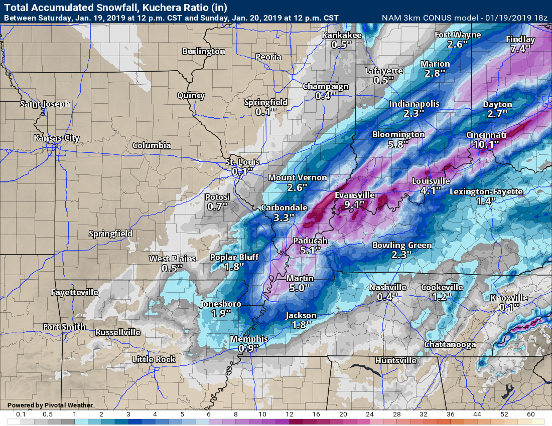
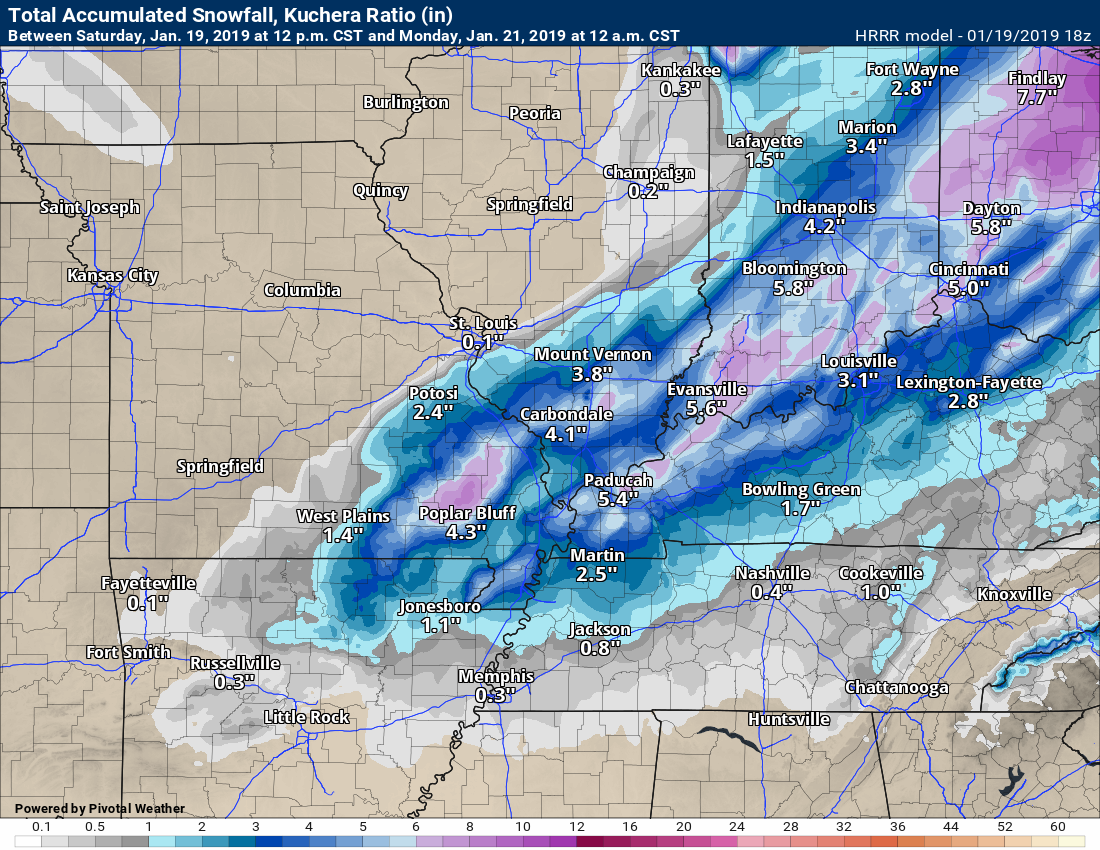
Not a forecast. Just showing you the models. They keep bouncing around final totals.
Either way, the main concern will be blowing snow, low visibility, and icy roads.
NAM model is bullish on totals
Here is the Hrrr model
1:20 PM
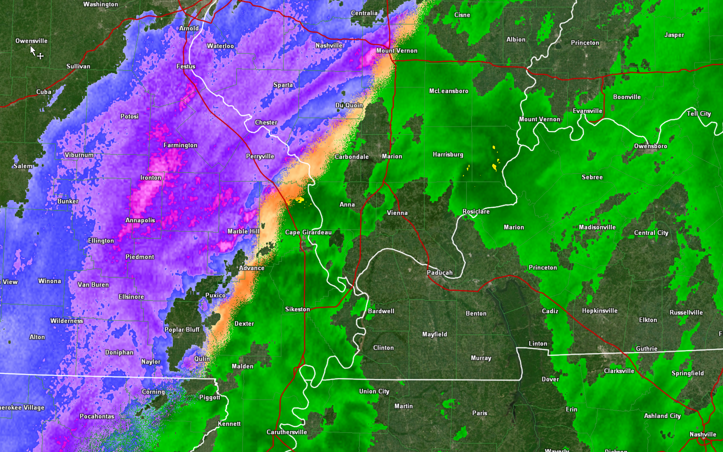
Sleet has reached Cape Girardeau, MO and Marion, IL
Ava, IL has snow now.
Numerous reports of 30 to 45 mph wind in SE MO with heavy snow. Whiteout conditions are being reported in southeast Missouri.
Snow totals of one to two inches per hour are likely at the peak of this event.
Blowing and drifting snow is a concern.
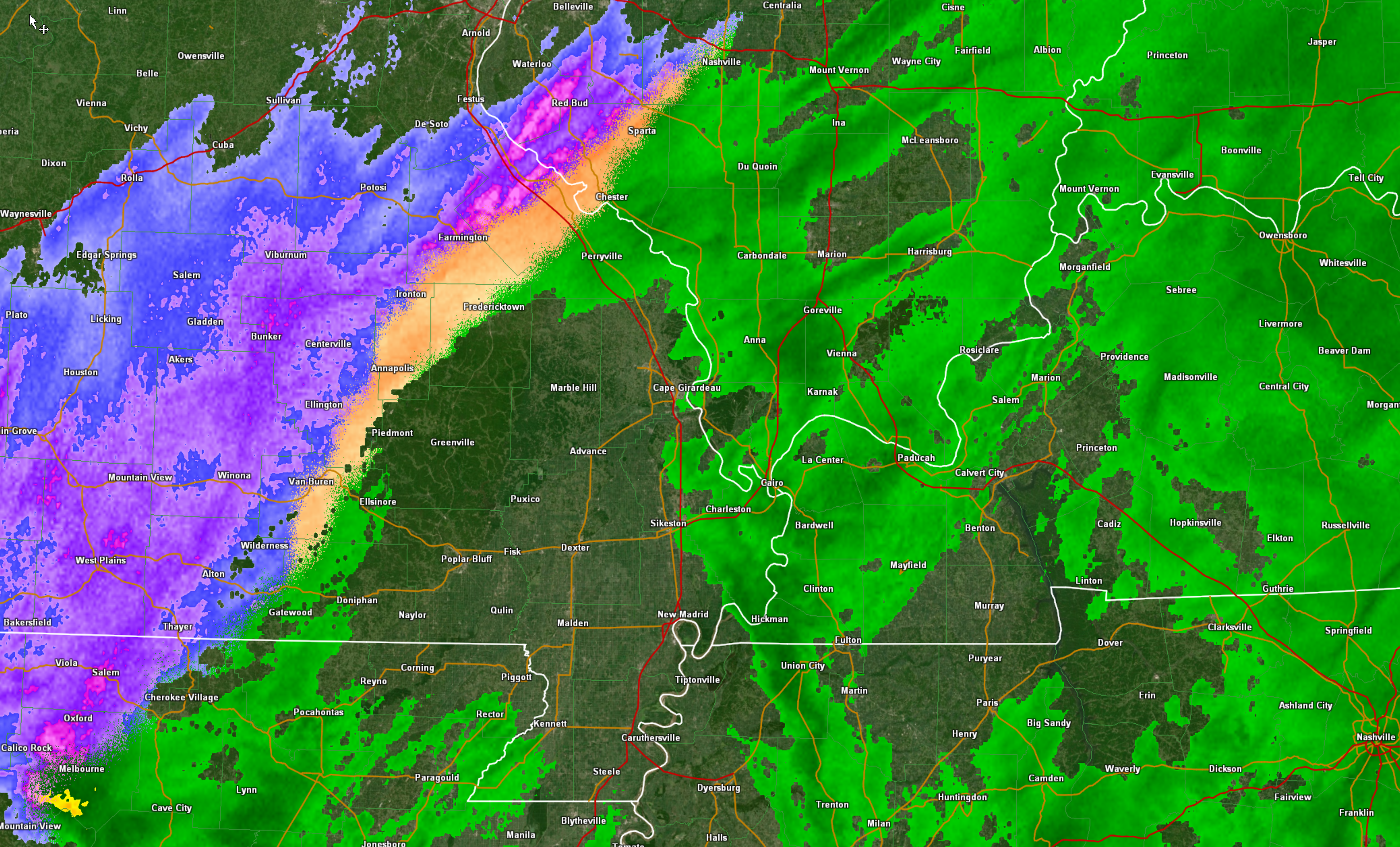
Radar
Link to live radar http://weatherobservatory.com/weather-radar.htm
11 AM
I left this one off
Ohio Valley Video Update
10:50 AM
Blue, purple, and pink are snow
Orange is sleet.
Green is rain.
What a mess!
View this radar live by clicking here
Here is the latest Hrrr model guidance future-cast radar
Blue is snow. Green is rain.
Purple is a mix.
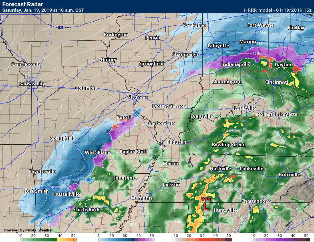
No major changes in the going forecast.
What has become clear is where to place the heavier band.
Last night I thought it might cut across our region. That appears to be what will happen.
I am concerned about the blowing snow reducing visibility.
At the peak of this storm, some areas could be near white-out conditions. That would actually be considered near blizzard conditions.
Blizzards don’t have anything to do with how much snow falls. It has to do with wind and visibility.
As a matter of fact, you don’t even have to have snow falling for a blizzard. Ground blizzards can happen simply from falling snow.
This storm, at peak, will have heavy snow with 30 to 40 mph wind gusts. That will create near impossible driving conditions for a period of time.
Don’t take this system lightly.
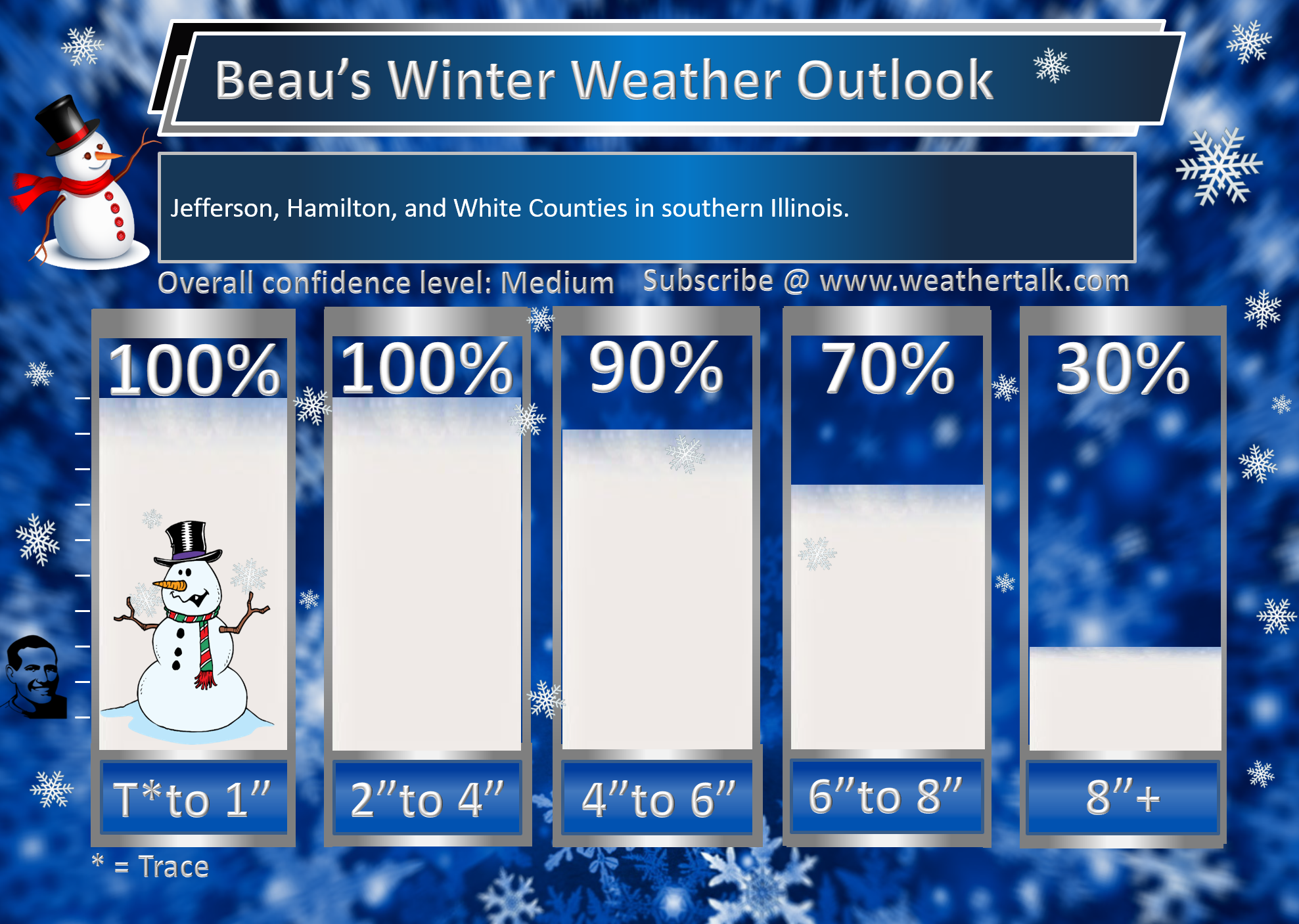
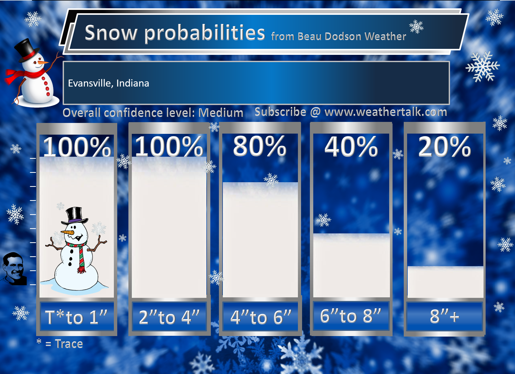
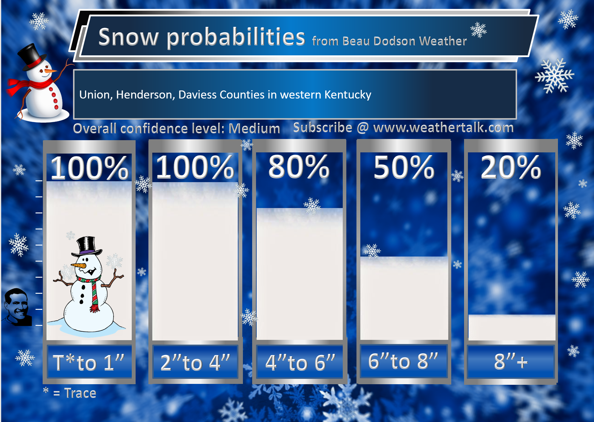
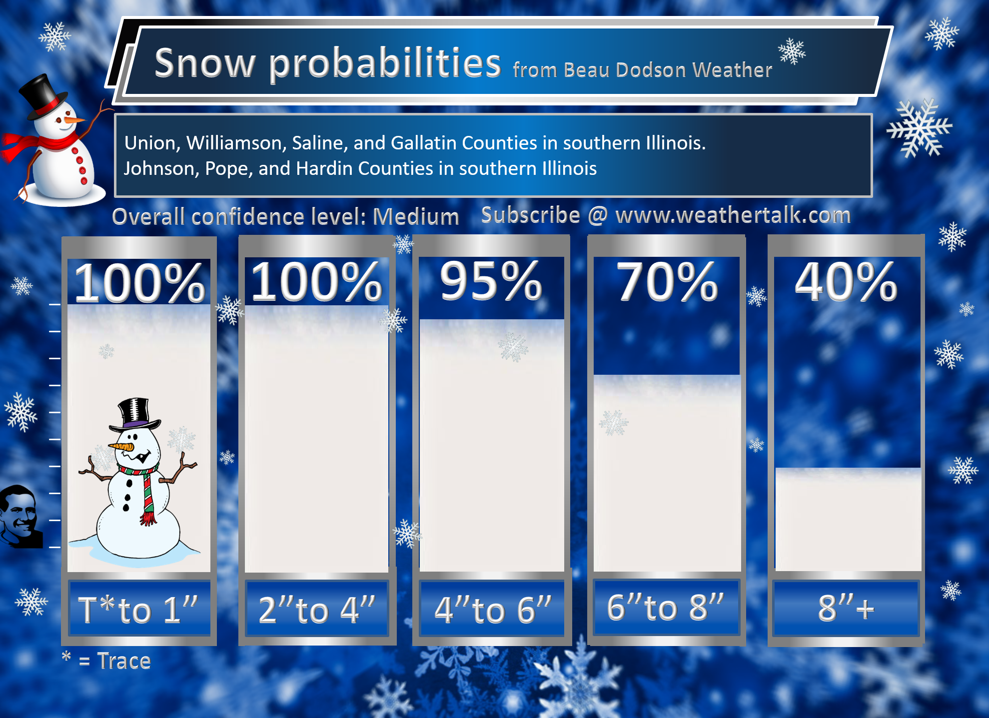
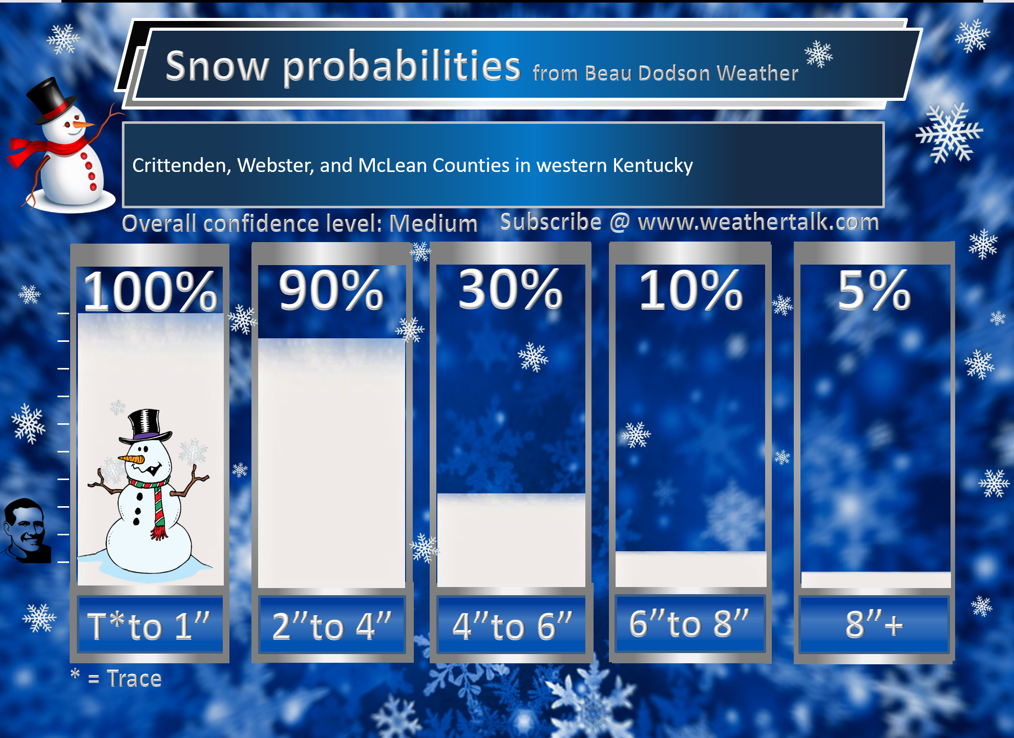
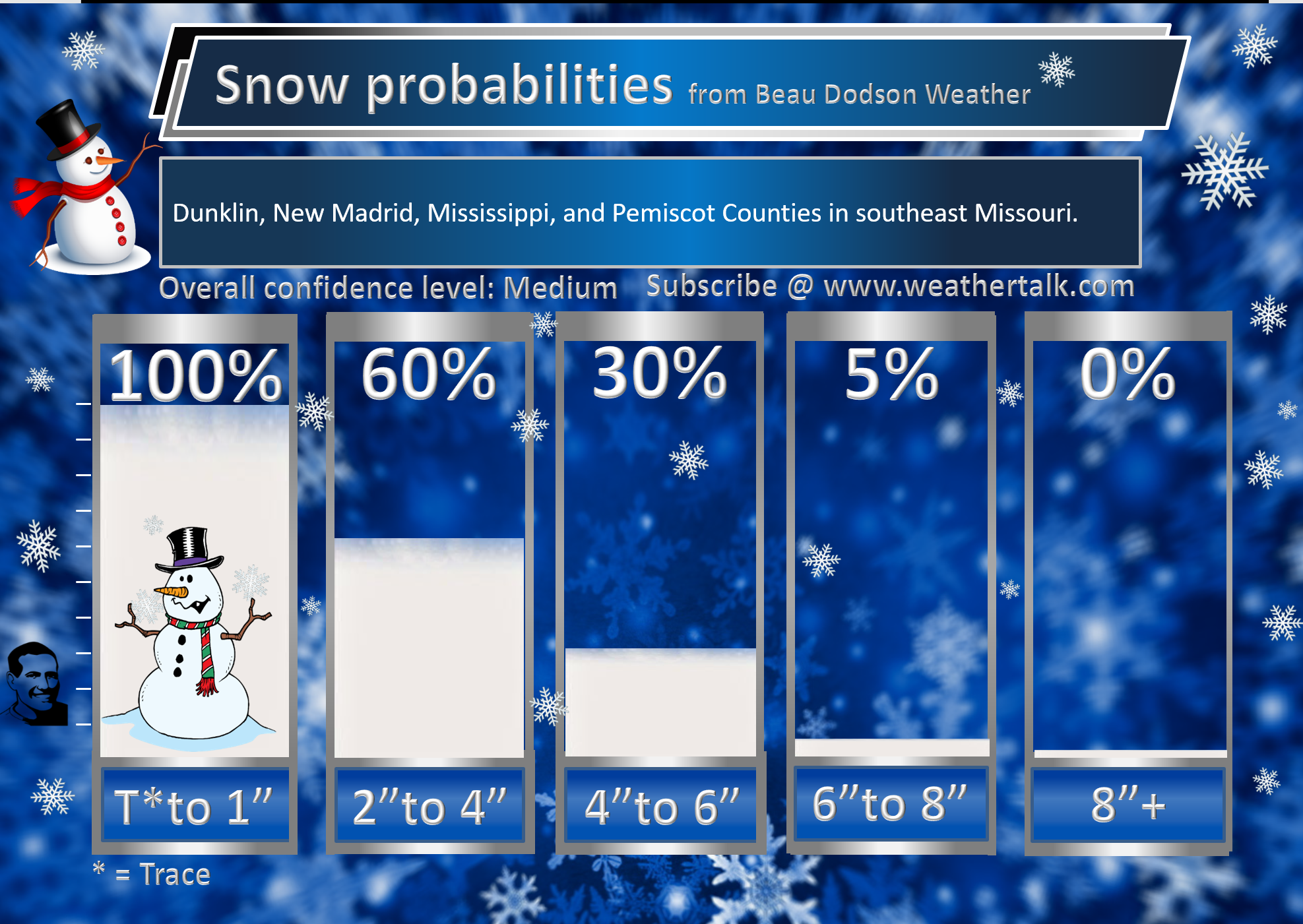
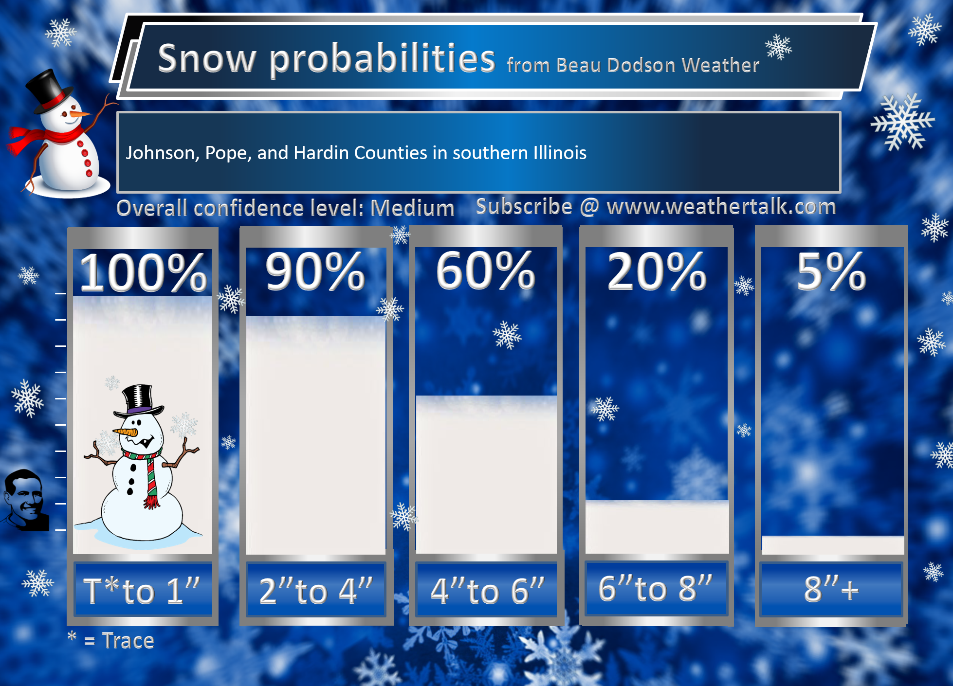
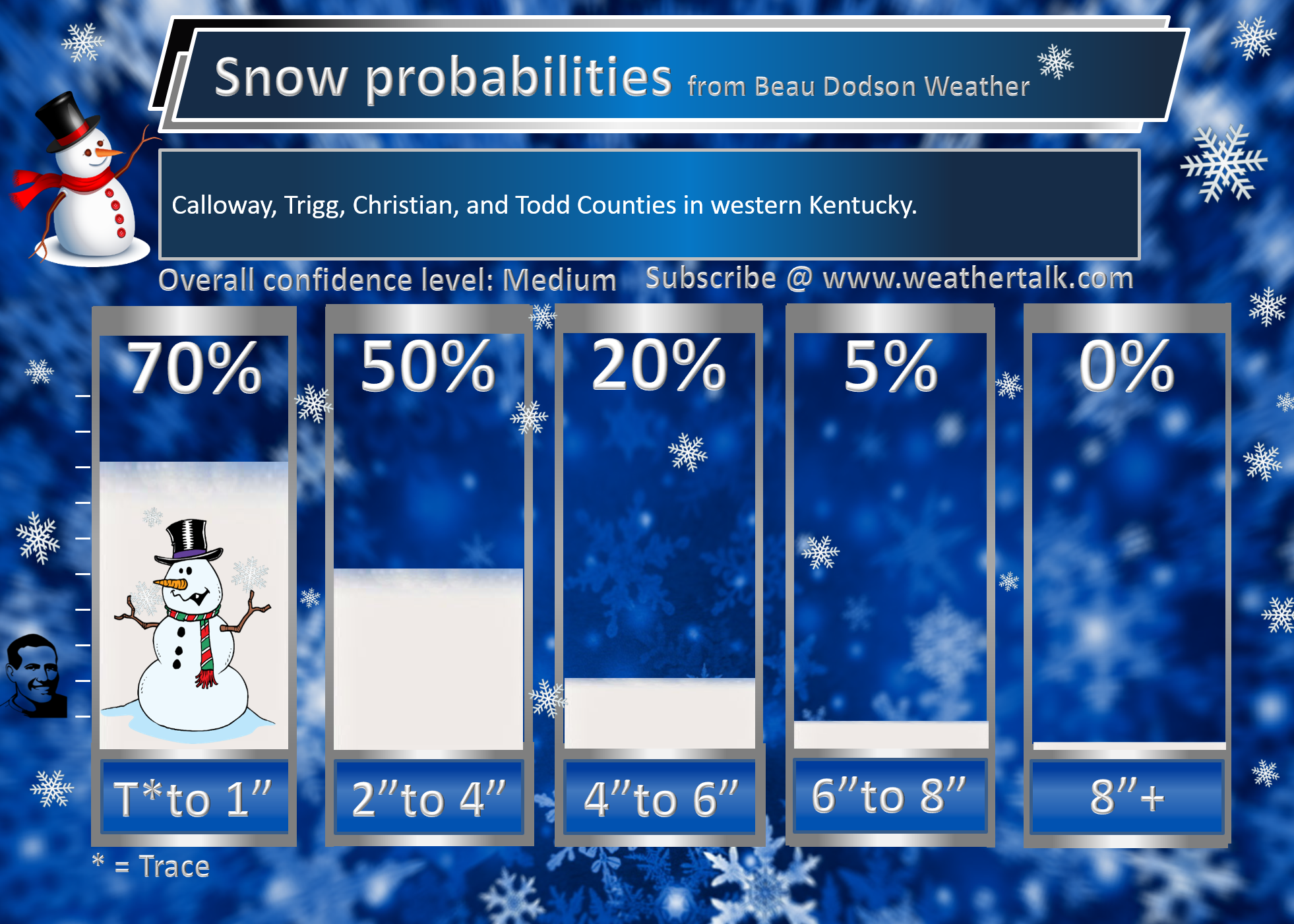
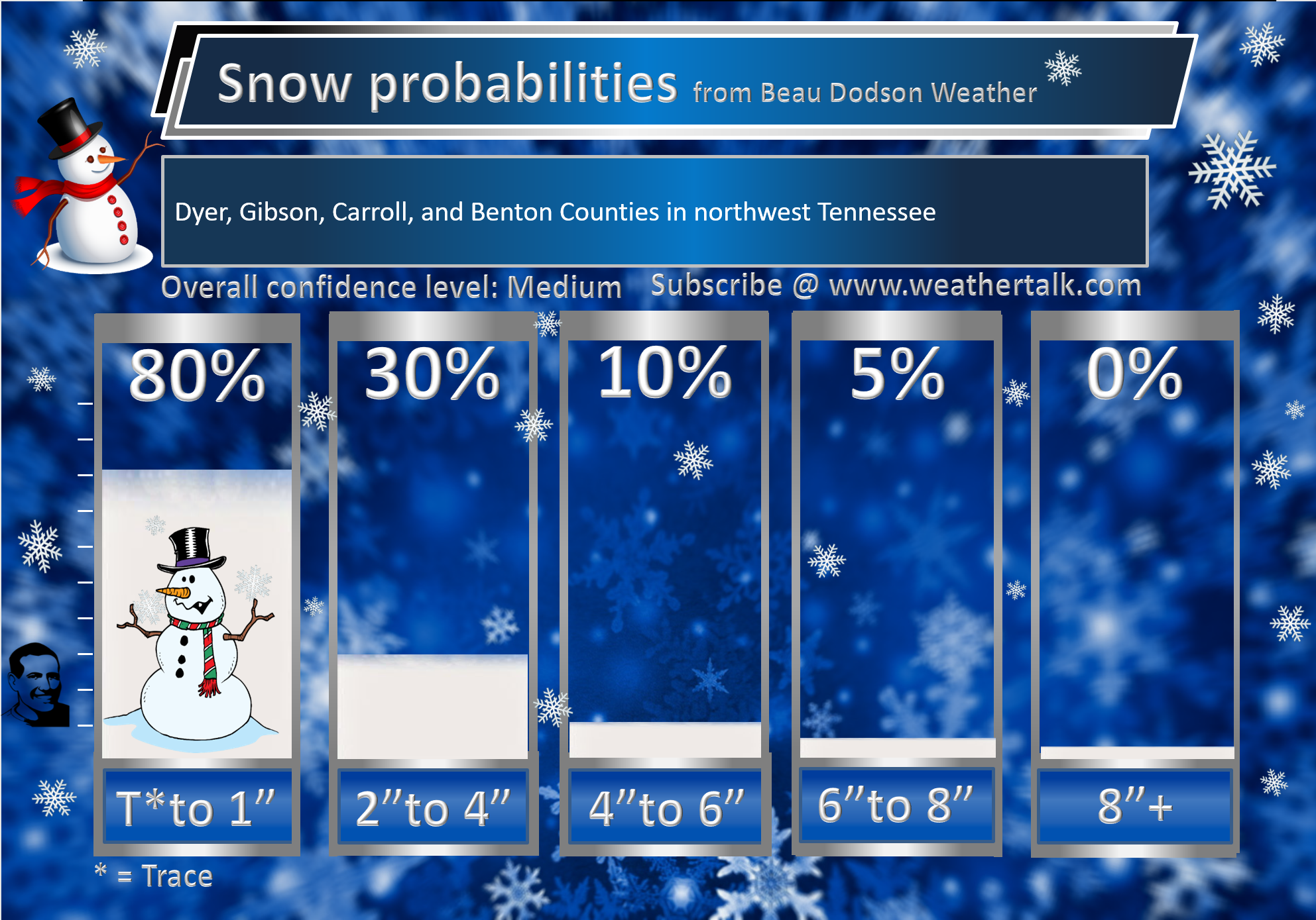
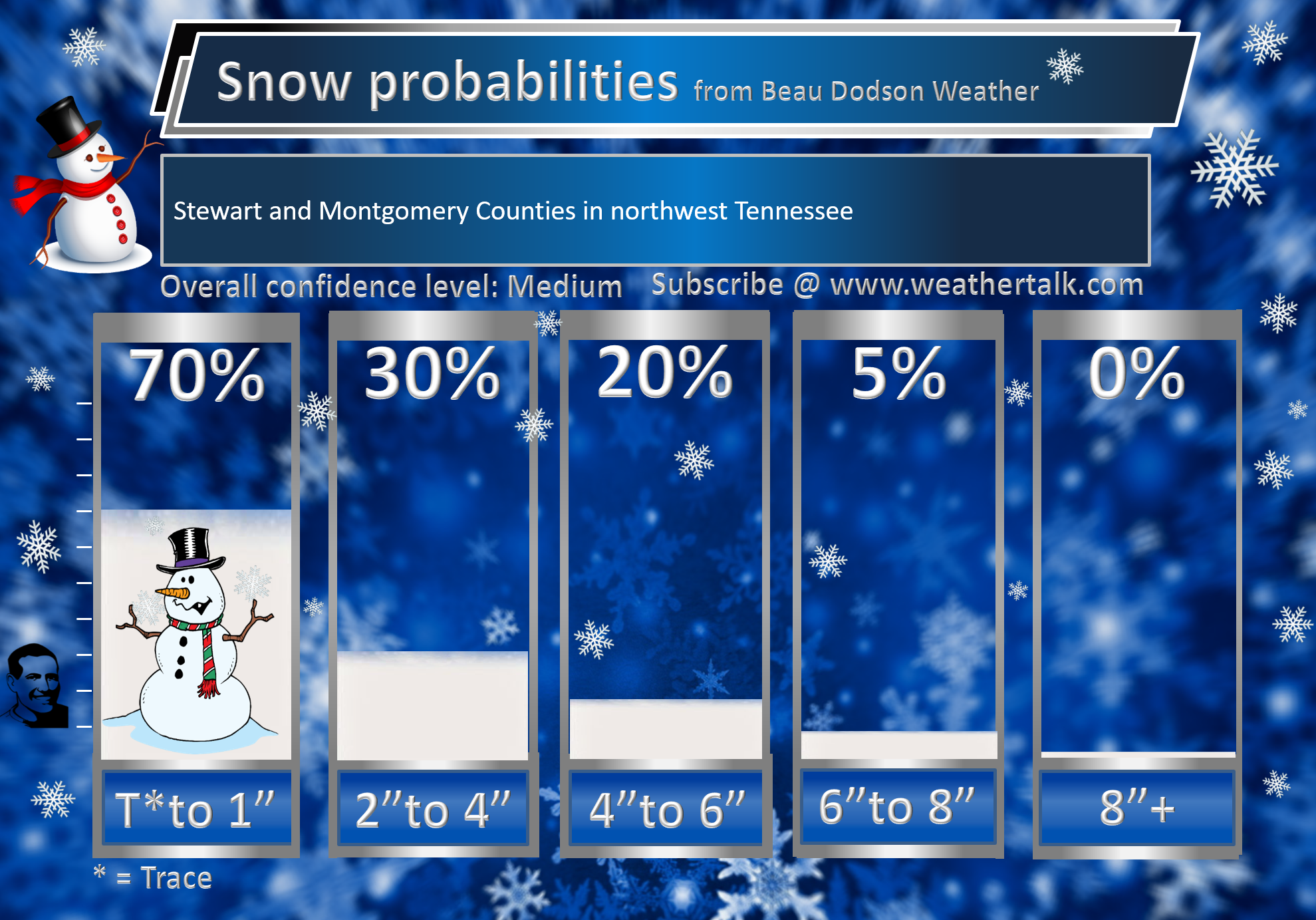
A widespread 1 to 3-inch snow event is forecast. I did increase that from previous wording of a widespread trace to two inches. I increased it an inch.
I have always known there would likely be a 3 to 6-inch snow band. I just was not sure where to place it.
I have updated all of the probability numbers below. I increased the % numbers since confidence is higher.
I also spelled out where the heaviest band is likely to occur. You will see that reflected in the % numbers.
Don’t forget to hit the winterize button on the city-view radars. That will turn on the precip typing for you.
It looks like this
Here is the radar link
Click here for your interactive local city-view radars & regional radars.

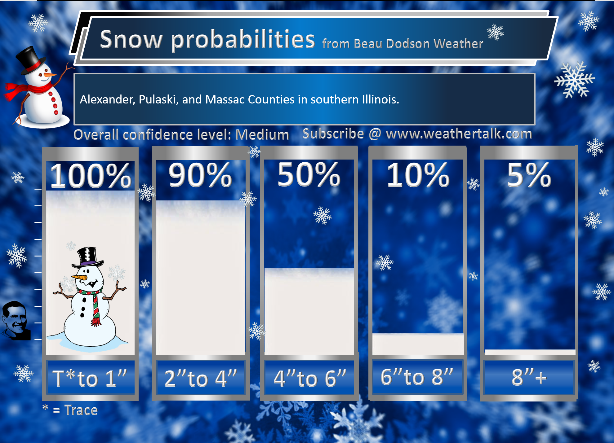
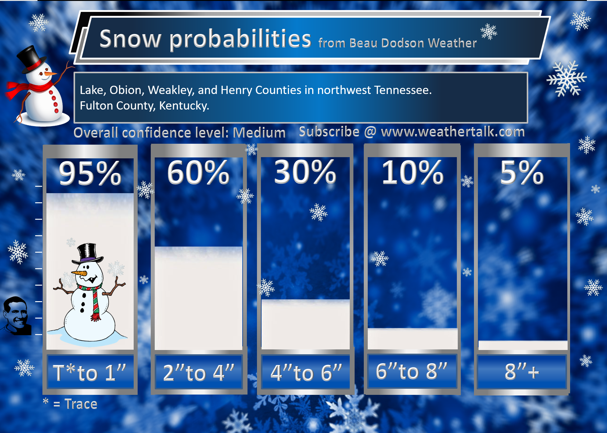
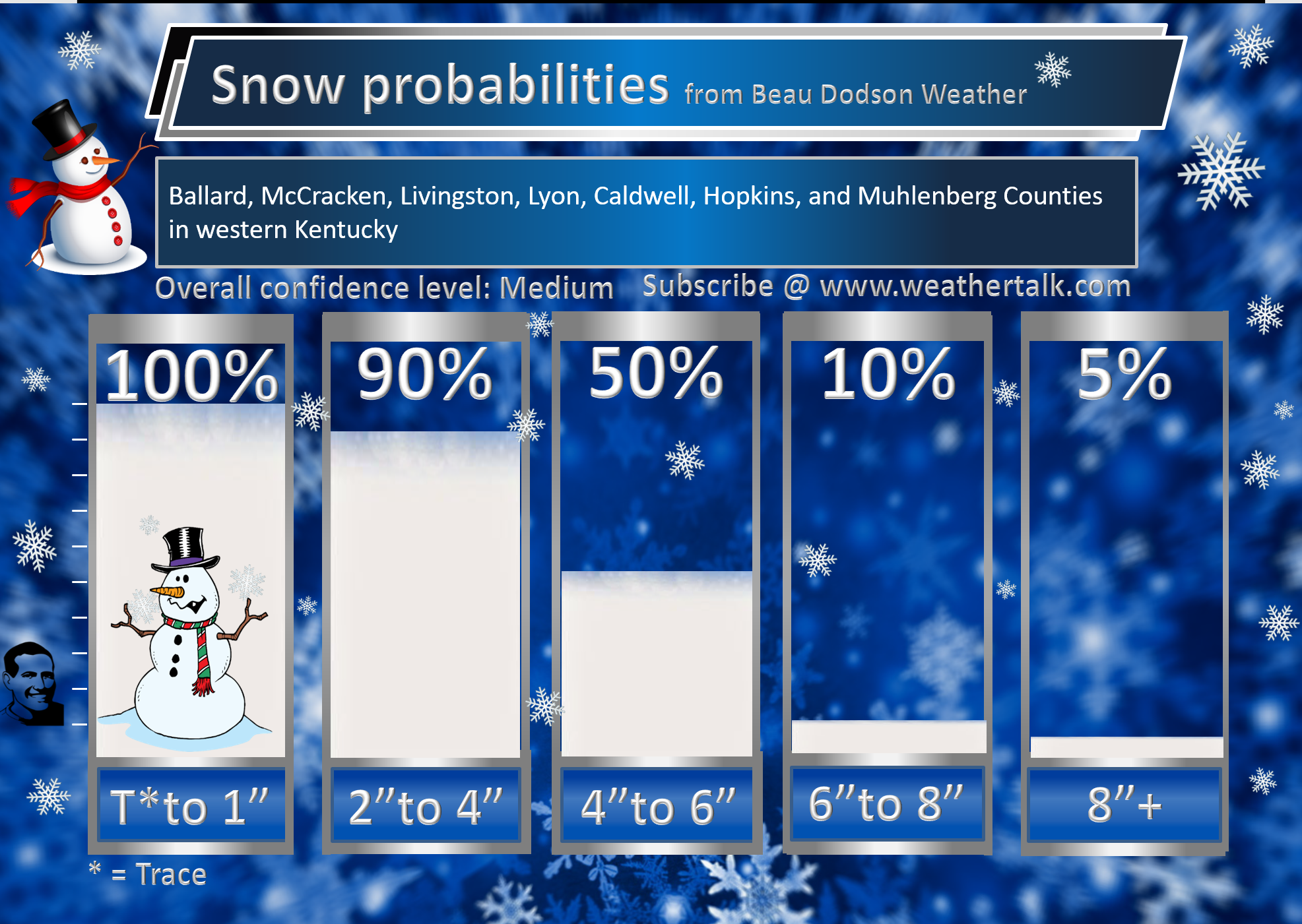
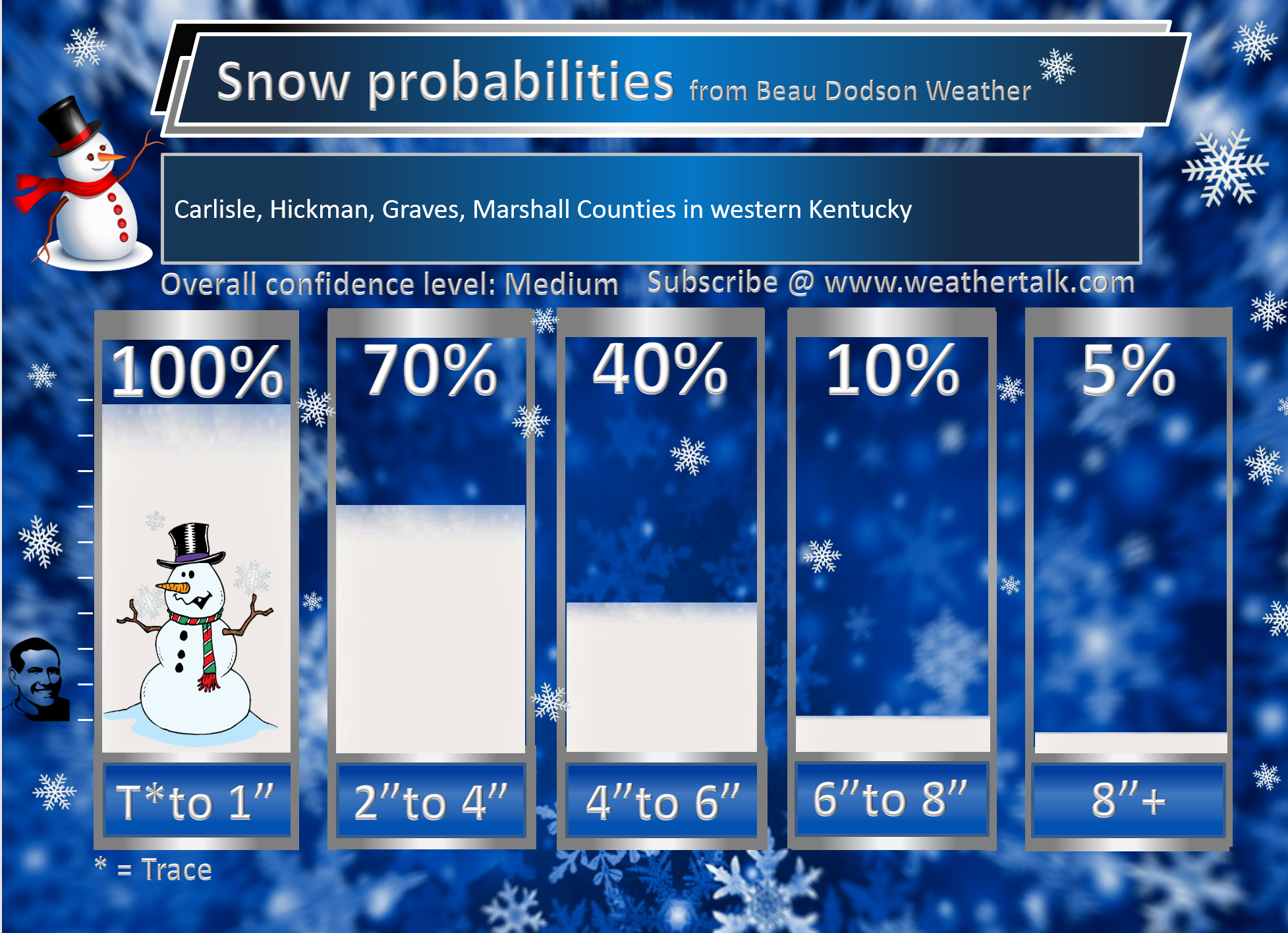
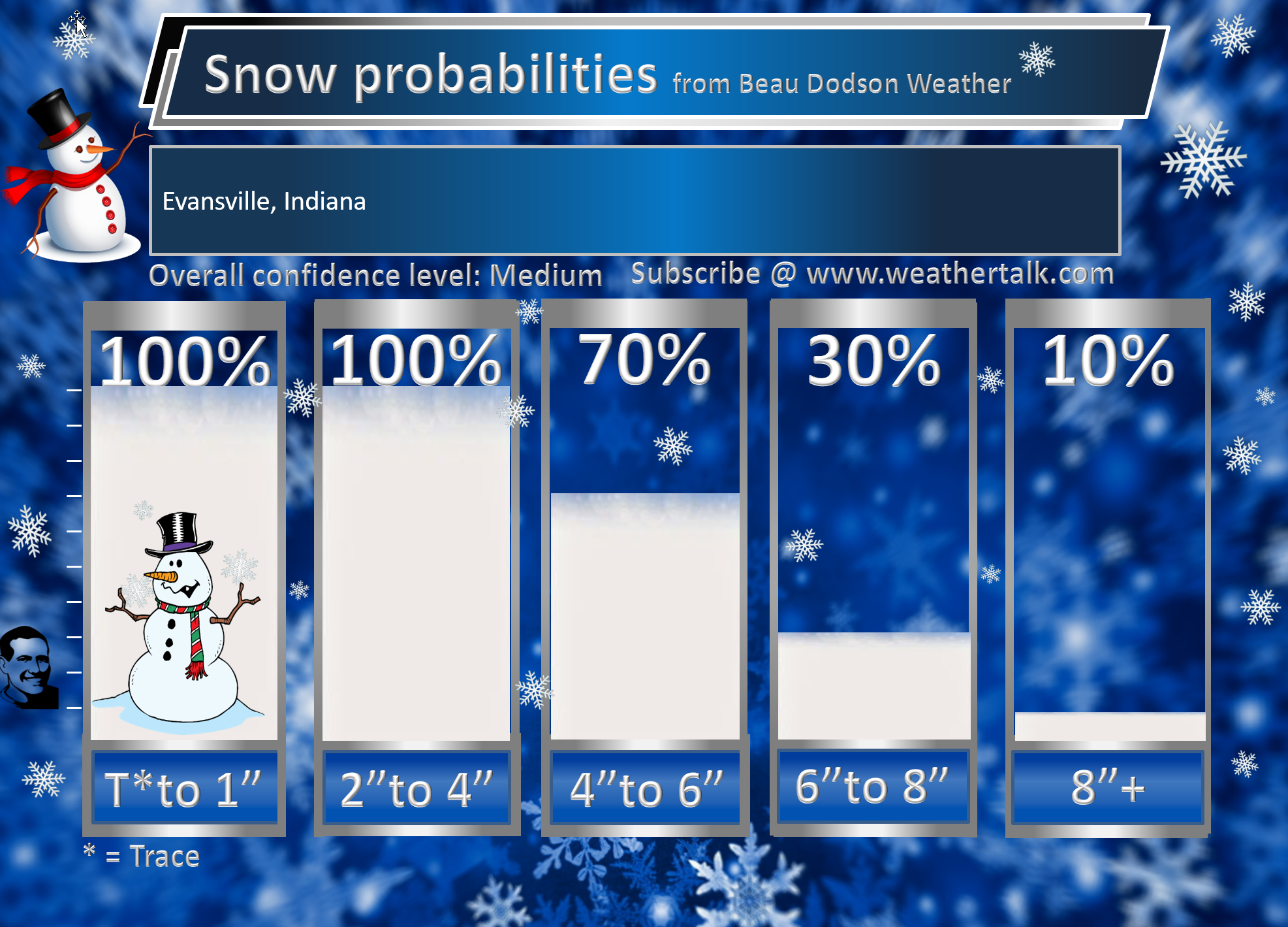
Here is the county by county break-down.
Keep hitting refresh and you will see more graphics over the coming hour.


NOTICE:
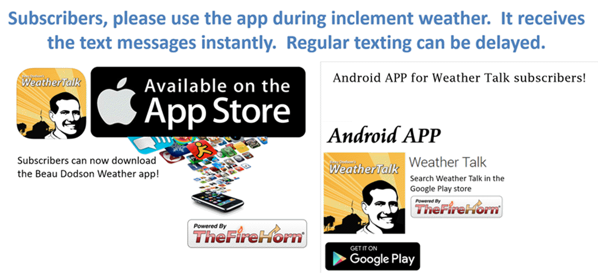
I encourage subscribers to use the app vs regular text messaging. They will be the same messages. We have found text messaging to be delayed during severe weather. The app typically will receive the messages instantly. I recommend people have three to four methods of receiving their severe weather information.
Remember, my app and text alerts are hand typed and not computer generated. You are being given personal attention during significant weather events.


Click here for your interactive local city-view radars & regional radars.
During winter weather be sure and click the winterize button above each city-view radar. This will show you the precipitation type.
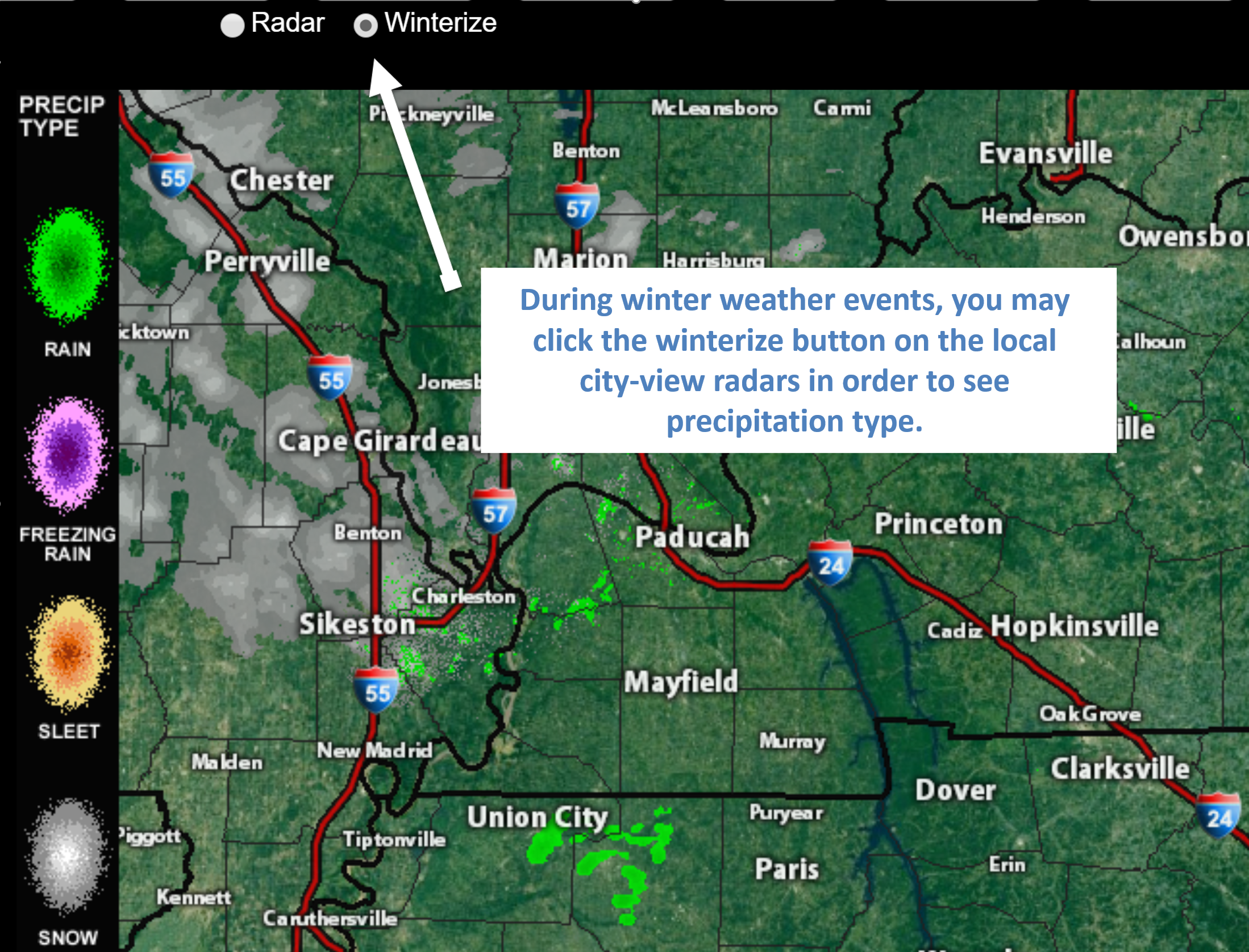
Click to enlarge this example of how to winterize your city-view radar.
You will also find clickable warning and advisory buttons.
If the radar is not updating then try another one. If a radar does not appear to be refreshing then hit Ctrl F5. You may also try restarting your browser.
Broken links? Something not working? Email me at beaudodson@usawx.com

Several items of interest in the long range portion of the forecast.
- Winter storm developing today.
- Near blizzard conditions at the peak of the storm.
- Flash freeze likely Saturday afternoon and night. That means rapidly falling temperatures while moisture remains on roadways. Whether the strong winds will dry the roads is questionable. If the road surfaces do not dry then icy spots are likely to develop.
- Another precipitation event arrives Tuesday and Wednesday. Monitoring Thursday and Friday, as well.
Is today or tomorrow an action weather day? Yes. Winter storm conditions developing.
What is an action weather day? It is a day when you need to monitor the forecast a bit closer. Inclement weather could impact your plans.
![]()
Key Message
- I will be live blogging today. Come back to this page and check for updates on the latest guidance.
- Low visibility will cause significant travel problems with this event. Falling and blowing snow, at the peak, will lower visibility to less than one quarter mile.
- Travel should be avoided during the peak.
January 19, 2019
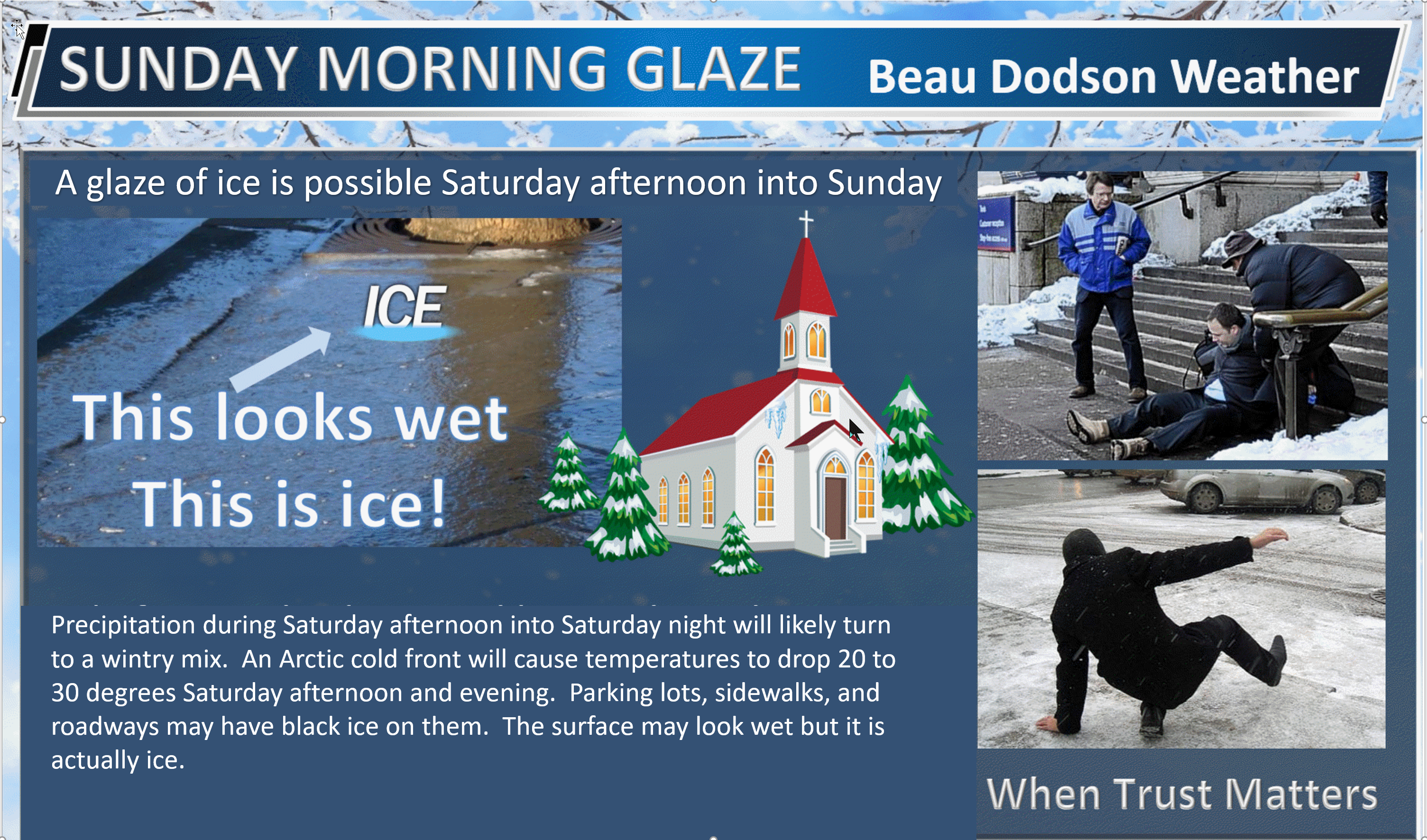
Winter weather alert Saturday afternoon and night.
Saturday’s Forecast: Rain changing to snow late this morning over my northwest counties in southeast Missouri and then the snow will spread south and east. Heavy snow, at times. Generally, one to four inches is anticipated. Blowing and drifting snow likely. Strong and gusty winds. Near blizzard conditions at the peak of the storm in the heaviest snow band. Remember, a blizzard has nothing to do with how much snow falls. It is simply high winds combined with falling snow. That creates low visibility.
My confidence in the forecast verifying: High (80% confidence in the forecast)
Temperature range: Temperatures will fall rapidly behind the cold front. This first occurs over southeast Missouri this morning and then spreads east through the day. the Pennyrile area of western Kentucky will be the last to drop below freezing.
Wind direction and speed: Southwest becoming west and northwest at 20 to 40 mph and gusty
Wind chill or heat index (feels like) temperature forecast: -5° to 15°
What is the chance/probability of precipitation? MO Bootheel 100% MO 100% IL 100% KY 100% TN 100%
Note: A 20% chance of rain does not mean it won’t rain. It simply means most areas will remain dry.
Coverage of precipitation: Widespread
Is flash flooding anticipated? No.
Will there be accumulating snow or ice? Yes. A one to four-inch snow event will occur in most counties. A band of three to six inches likely across the middle portion of the region. Blowing and drifting snow.
Will non-accumulating snow or ice occur? Yes
Are icy road conditions anticipated? Yes. Icy roads will develop from west to east across the region.
Is severe weather expected? No
The NWS officially defines severe weather as 58 mph wind or great, 1″ hail or larger, and/or tornadoes
Is lightning anticipated? Small risk of lightning in south-central Kentucky and western Tennessee.
What impacts are anticipated from the weather? Wet roadways. Icy roads. Heavy snow will lower visibility later today. Drifting snow. Low wind chill values.
Should I cancel my outdoor plans? Have a plan B.
UV Index: 1 Low
Sunrise: 7:07 AM
Saturday Night Forecast Details:
Winter weather alert Saturday afternoon and night.
Forecast: Windy. Cold. Low wind chill values. Snow ending. Blowing snow will continue.
My confidence in the forecast verifying: High (80% confidence in the forecast)
Temperature range: MO Bootheel 16° to 22° SE MO 15° to 20° South IL 14° to 18° West KY 20° to 25° NW TN 25° to 30°
Wind direction and speed: Becoming northwest and north at 15 to 30 mph with gusts to 40 mph
Wind chill or heat index (feels like) temperature forecast: -10° to 10°
What is the chance/probability of precipitation? Ending west to east
Note: A 20% chance of rain does not mean it won’t rain. It simply means most areas will remain dry.
Coverage of precipitation: Ending
Is flash flooding anticipated? No
Will there be accumulating snow or ice? Yes.
Will non-accumulating snow or ice occur? Yes
Are icy road conditions anticipated? Yes
Is severe weather expected? No
The NWS officially defines severe weather as 58 mph wind or great, 1″ hail or larger, and/or tornadoes
Is lightning anticipated? No
What impacts are anticipated from the weather? Icy roads. Heavy snow will lower visibility later today. Drifting snow. Low wind chill values.
Should I cancel my outdoor plans? Have a plan B
Sunset: 5:05 PM
Moonrise: 3:37 PM
The phase of the moon: Waxing Gibbous
Moonset: 5:30 AM
January 20, 2019
Sunday’s Forecast: Mostly loudy. Windy. Colder. Low wind chill values. Snow showers possible.
My confidence in the forecast verifying: Medium (60% confidence in the forecast)
Temperature range: MO Bootheel 26° to 28° SE MO 24° to 28° South IL 24° to 26° West KY 24° to 26° NW TN 25° to 30°
Wind direction and speed: North at 15 to 30 mph and gusty.
Wind chill or heat index (feels like) temperature forecast: 10° to 15°
What is the chance/probability of precipitation? MO Bootheel 20% MO 20% IL 30% KY 30% TN 20%
Note: A 20% chance of rain does not mean it won’t rain. It simply means most areas will remain dry.
Coverage of precipitation: Patchy
Is flash flooding anticipated? No
Will there be accumulating snow or ice? Monitor
Will non-accumulating snow or ice occur? Possible
Are icy road conditions anticipated? Yes
Is severe weather expected? No
The NWS officially defines severe weather as 58 mph wind or great, 1″ hail or larger, and/or tornadoes
Is lightning anticipated? No
What impacts are anticipated from the weather? Icy roads. Blowing snow in some areas. Black ice. Bitterly cold wind chill values.
Should I cancel my outdoor plans? Have a plan B.
UV Index: 1 Low
Sunrise: 7:07 AM
Sunday Night Forecast Details:
Forecast: Partly cloudy. Bitterly cold. Low wind chill values. Temperatures will vary based on snow cover and clearing. If sky conditions clear then temperatures would be colder over a snow-pack. Still some questions on the chance of snow.
My confidence in the forecast verifying: Medium (60% confidence in the forecast)
Temperature range: MO Bootheel 16° to 18° SE MO 14° to 18° South IL 14° to 18° West KY 14° to 18° NW TN 18° to 24°
Wind direction and speed: North and northwest at 6 to 12 mph with gusts to 30 mph
Wind chill or heat index (feels like) temperature forecast: 0° to 15°
What is the chance/probability of precipitation? MO Bootheel 0% MO 0% IL 0% KY 0% TN 0%
Note: A 20% chance of rain does not mean it won’t rain. It simply means most areas will remain dry.
Coverage of precipitation: None
Is flash flooding anticipated? No
Will there be accumulating snow or ice? No
Will non-accumulating snow or ice occur? No
Are icy road conditions anticipated? Monitor the chance of icy road conditions. A bit early for certainties.
Is severe weather expected? No
The NWS officially defines severe weather as 58 mph wind or great, 1″ hail or larger, and/or tornadoes
Is lightning anticipated? No
What impacts are anticipated from the weather? Low wind chill values. Icy roads may remain in some areas.
Should I cancel my outdoor plans? It will not be uncomfortable outside. Have a plan B. Monitor the potential of icy roadways remaining.
Sunset: 5:06 PM
Moonrise: 4:43 PM
The phase of the moon: Full moon
Moonset: 6:34 AM
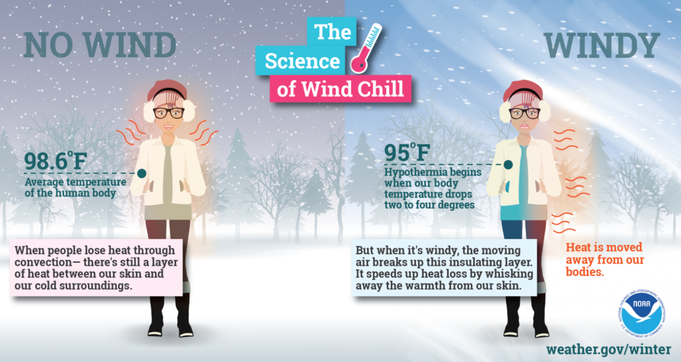
Wind chill temperatures Saturday afternoon into Monday morning will be cold.
Wind chills will be even colder if we have a snowpack. Keep that in mind.
Click here for your interactive local city-view radars & regional radars.
During winter weather be sure and click the winterize button above each city-view radar. This will show you the precipitation type.

The National Weather Service defines a severe thunderstorm as one that produces quarter size hail or larger, 58 mph winds or greater, and/or a tornado.
Today through next Tuesday: Severe weather is not anticipated. I am monitoring the risk of lightning by Friday night into Saturday. That would most likely be across parts of Kentucky and Tennessee. At this time, severe weather appears unlikely.
Interactive live weather radar page. Choose the city nearest your location. If one of the cities does not work then try a nearby one. Click here.
National map of weather watches and warnings. Click here.
Storm Prediction Center. Click here.
Weather Prediction Center. Click here.

Live lightning data: Click here.

Interactive GOES R satellite. Track clouds. Click here.

Here are the latest local river stage forecast numbers Click Here.
Here are the latest lake stage forecast numbers for Kentucky Lake and Lake Barkley Click Here.
Find me on Facebook!

Find me on Twitter!

Did you know that a portion of your monthly subscription helps support local charity projects?
You can learn more about those projects by visiting the Shadow Angel Foundation website and the Beau Dodson News website.
