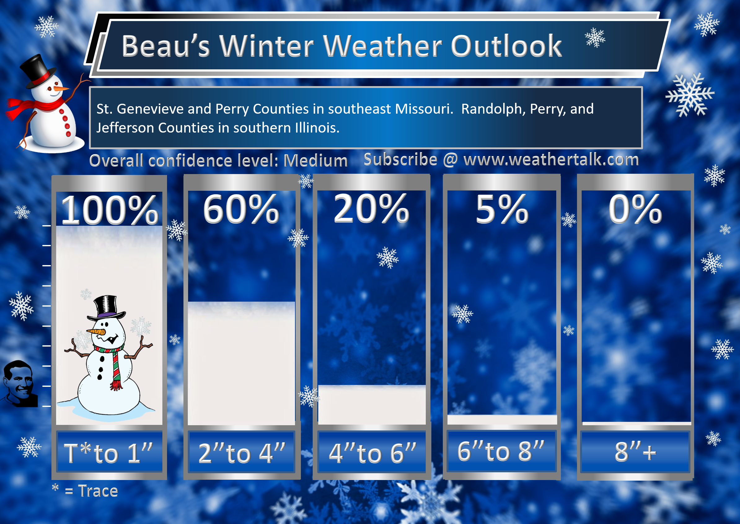
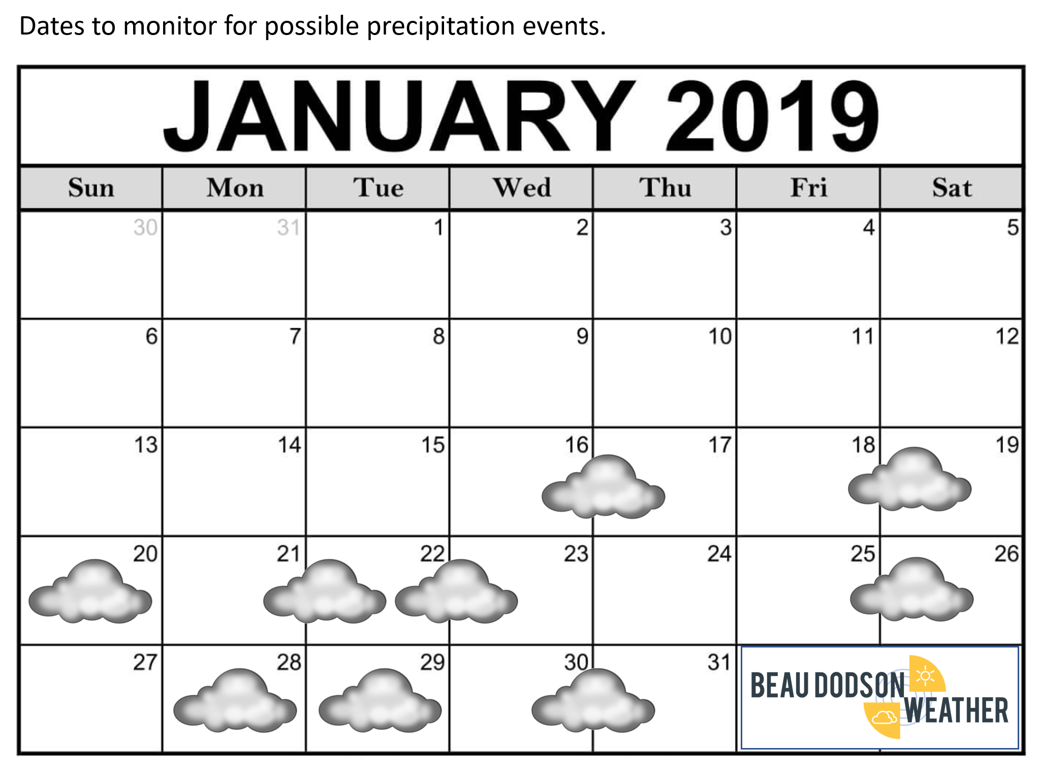
SATURDAY UPDATE
MOVE OVER TO THIS THREAD
Link
https://cms.weathertalk.com/43739-2/
10:30 PM
I am starting to question the area in blue as far as snow totals. Warm air is way north with this thing tonight. If I adjust the forecast it is possible this is the area that will need adjusting (lower)
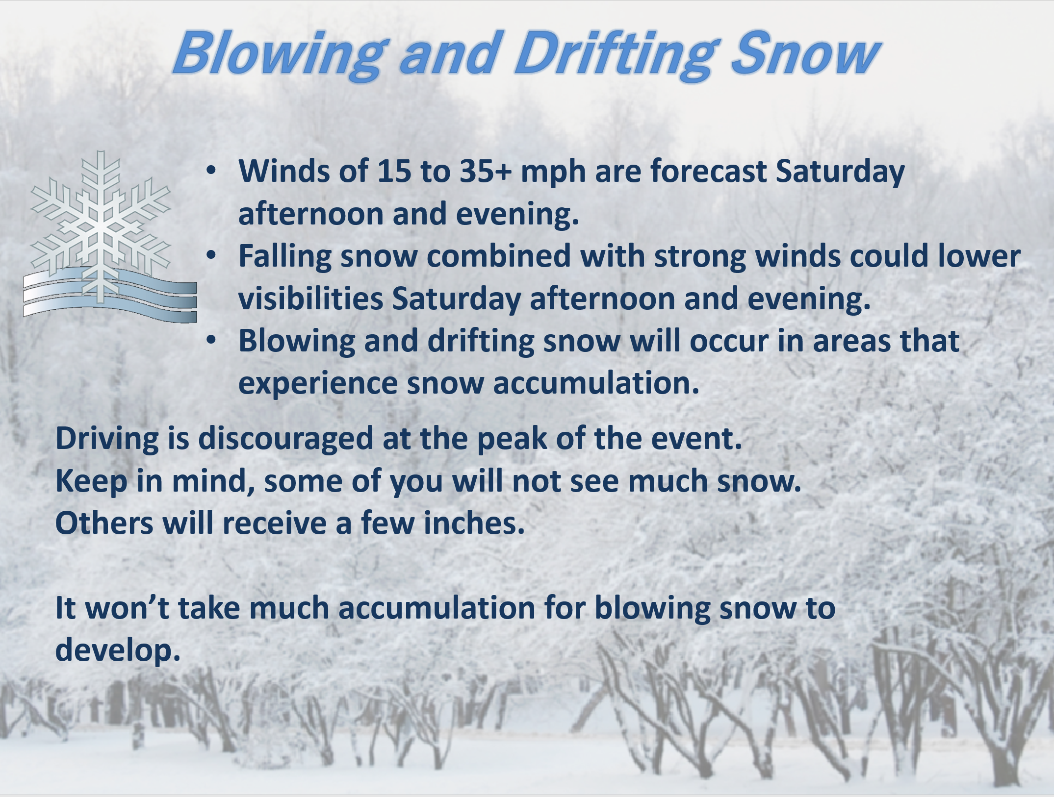
I am keying in on this area for the heaviest snow band. Three or more inches likely. Near blizzard conditions with low visibility and high winds.
Remember, a blizzard has nothing to do with how much snow falls. It has to do with visibility and blowing snow.
Peak of the storm will produce dangerous driving conditions.
Travel is not encouraged during the peak of the storm.
10 PM
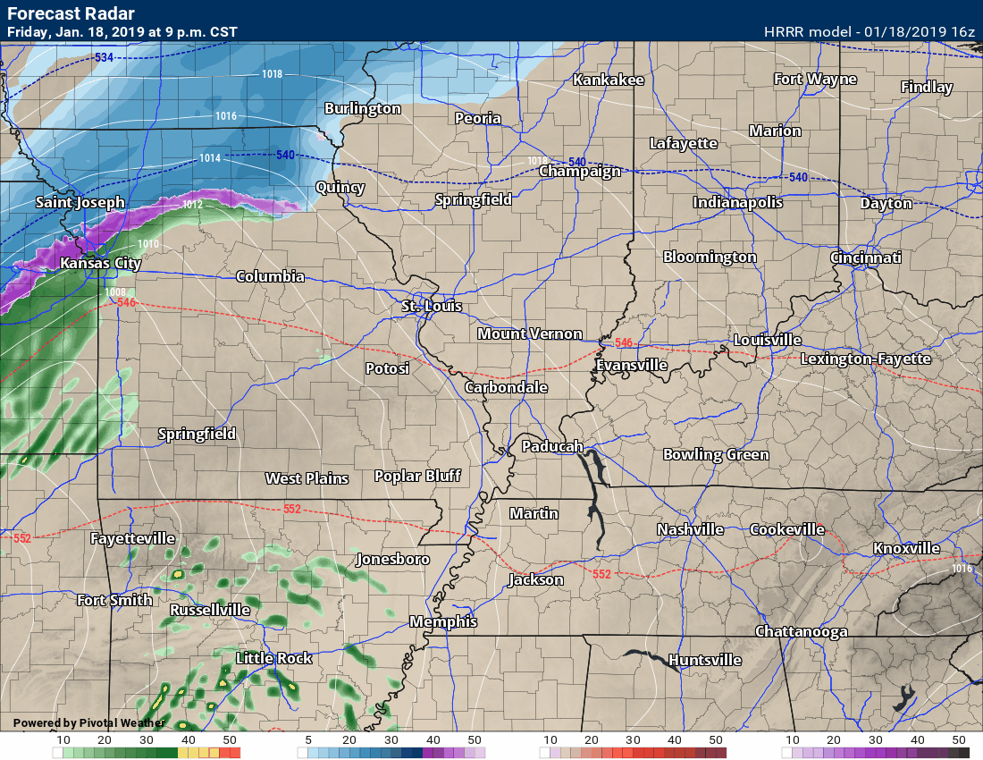
Radars
Small hail possible tonight with thunderstorms.
http://weatherobservatory.com/radar_pbluff.htm
8:30 PM
Radar link https://imagery.weathertalk.com/prx/RadarLoop.mp4
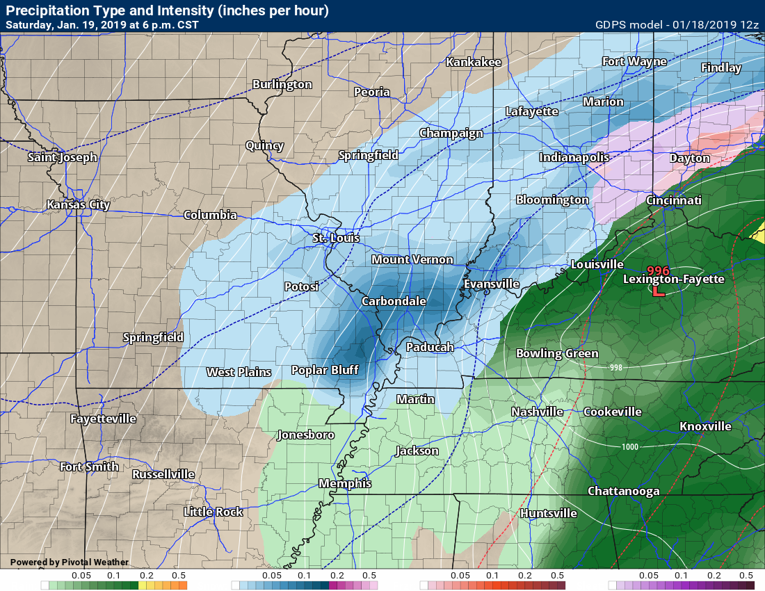
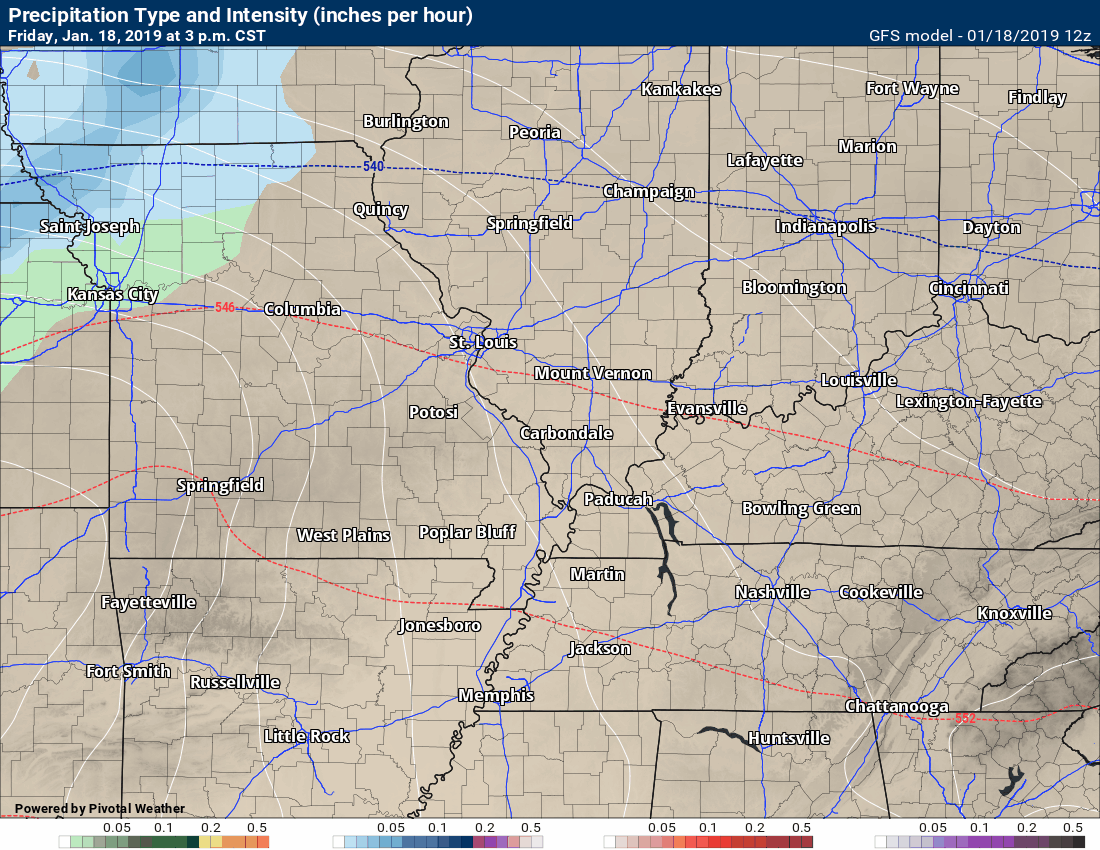
White and blue represent snow. Red/ping represent ice. Green is rain.
Thunderstorms are being reported in some areas.
Lightning in the bright blue and white.
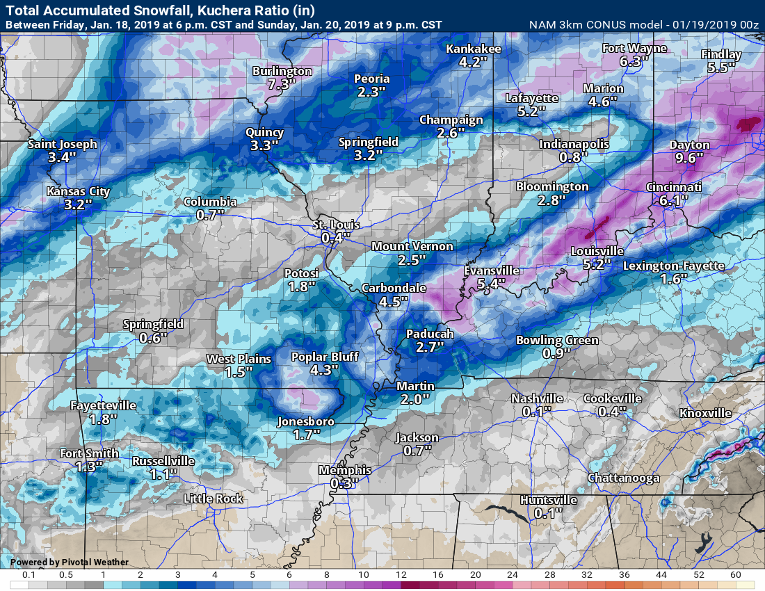
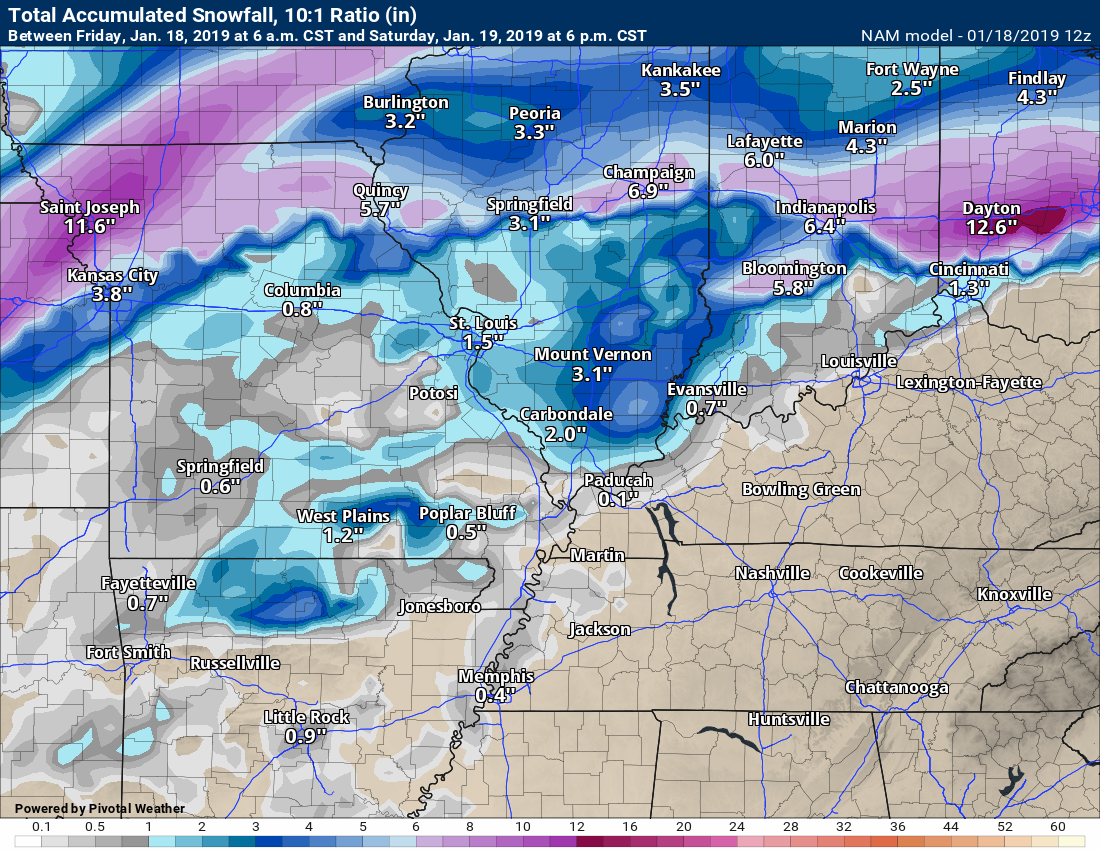
Here is the evening NAM 3K model guidance snow forecast.
One model of many. It places the heavier band a bit further south than some other models.
7:30 PM
Milk and cookies with Beau Facebook thread CLICK HERE
Keep scrolling down for new graphics.
Here is the key message for tomorrow and Sunday.
This event will begin tonight as rain. The rain could be heavy at times. A few thunderstorms are possible.
Rain totals of 0.80″ to 1.60″ will be common-place. Locally higher totals in thunderstorms.
The risk of severe weather is small. I will monitor areas near and east of LBL in west KY and then west TN, as well. A couple of storms could be heavier in those areas. Again, a small risk of severe weather.
The main concern arrives with the Arctic cold front late tomorrow morning and then into the afternoon and evening.
At the peak of the snow event, there will be low visibilities in some of our counties. That will be because of falling snow and blowing snow.
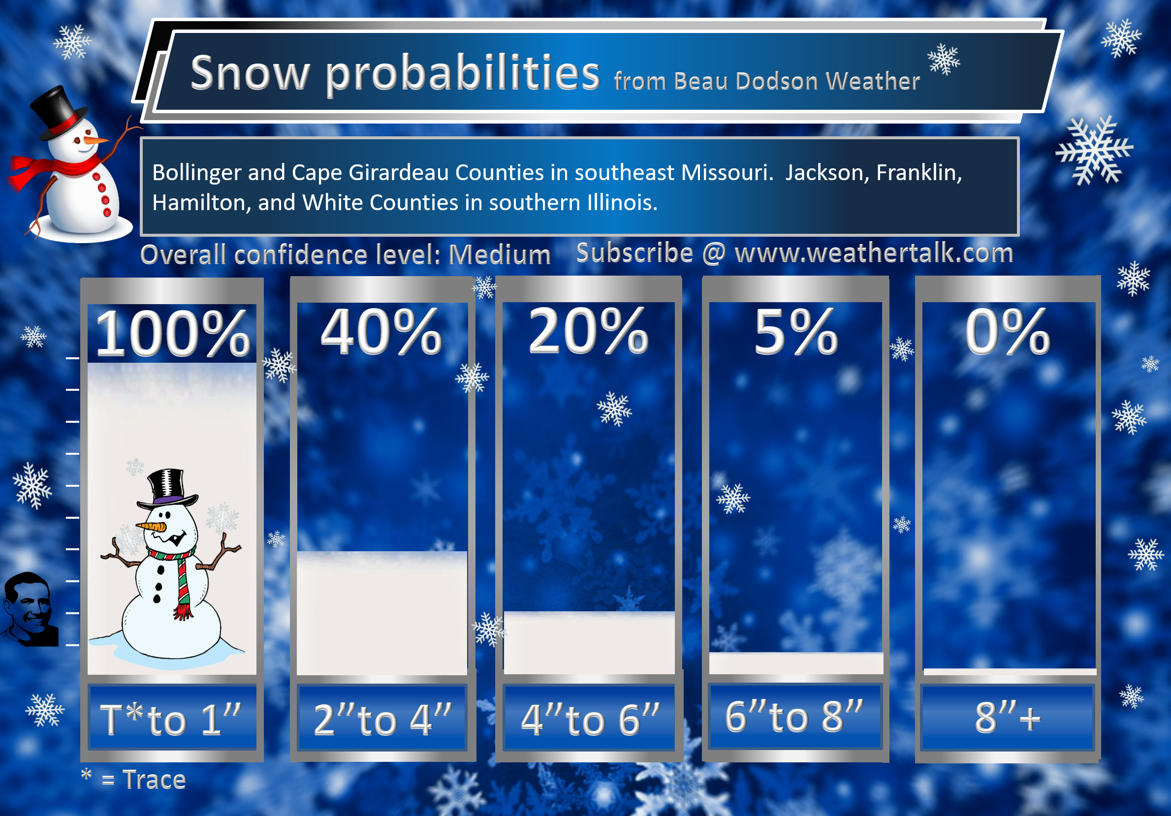
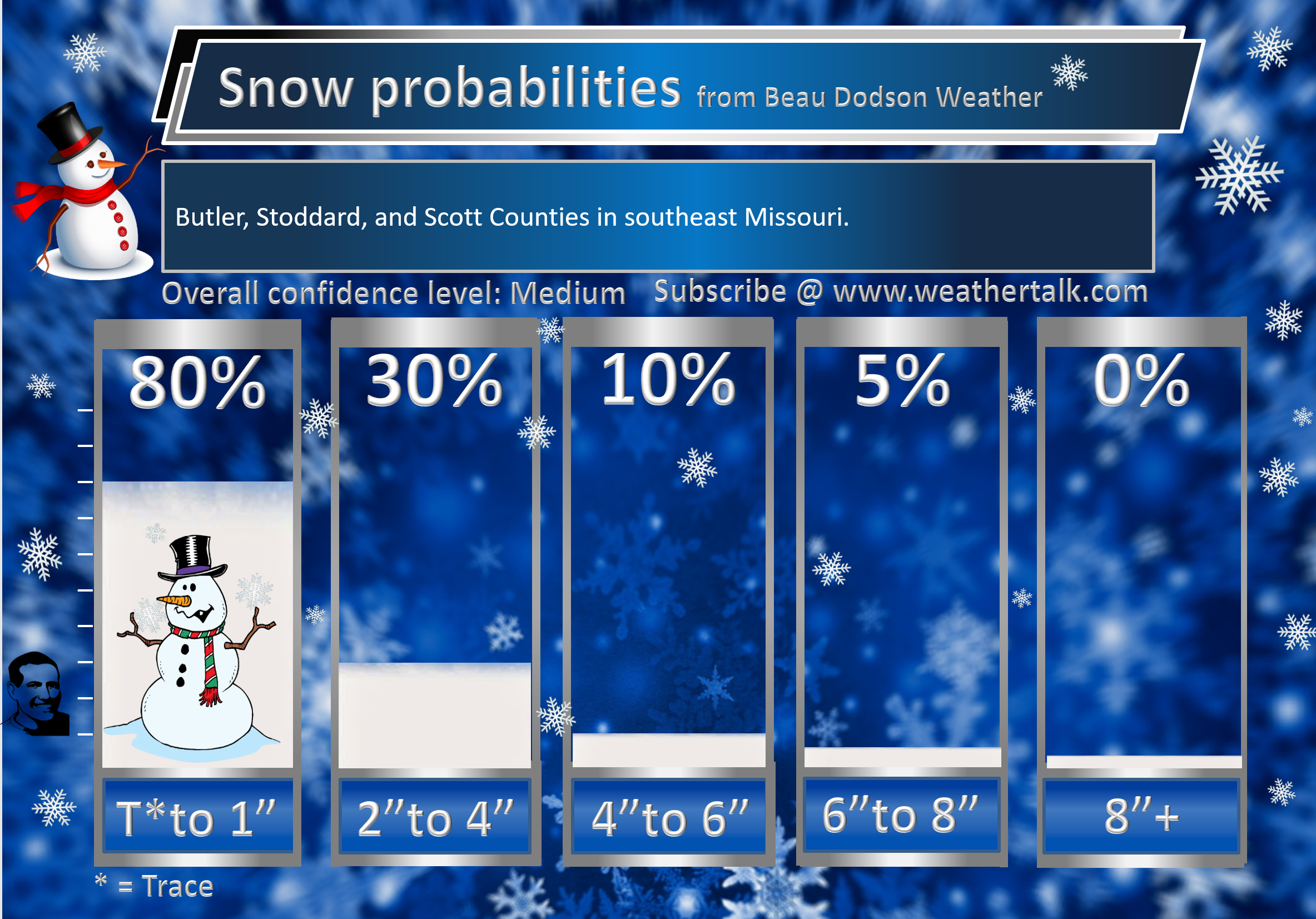
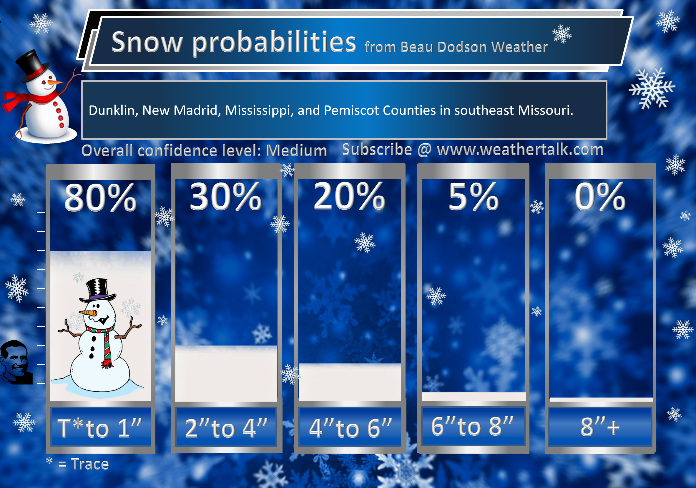
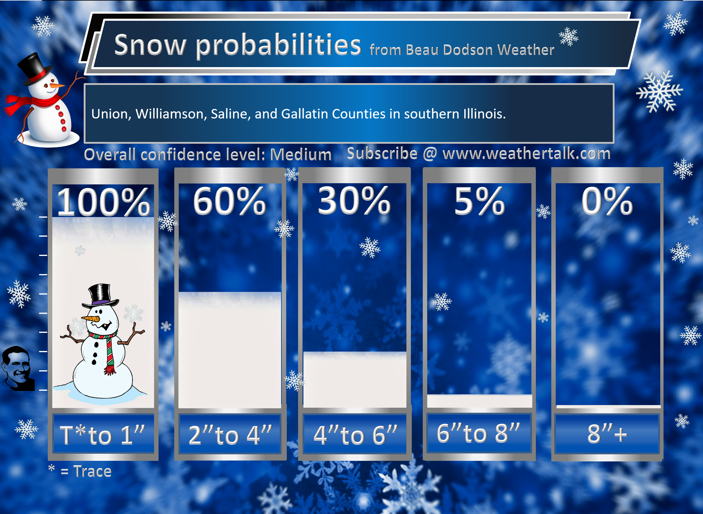
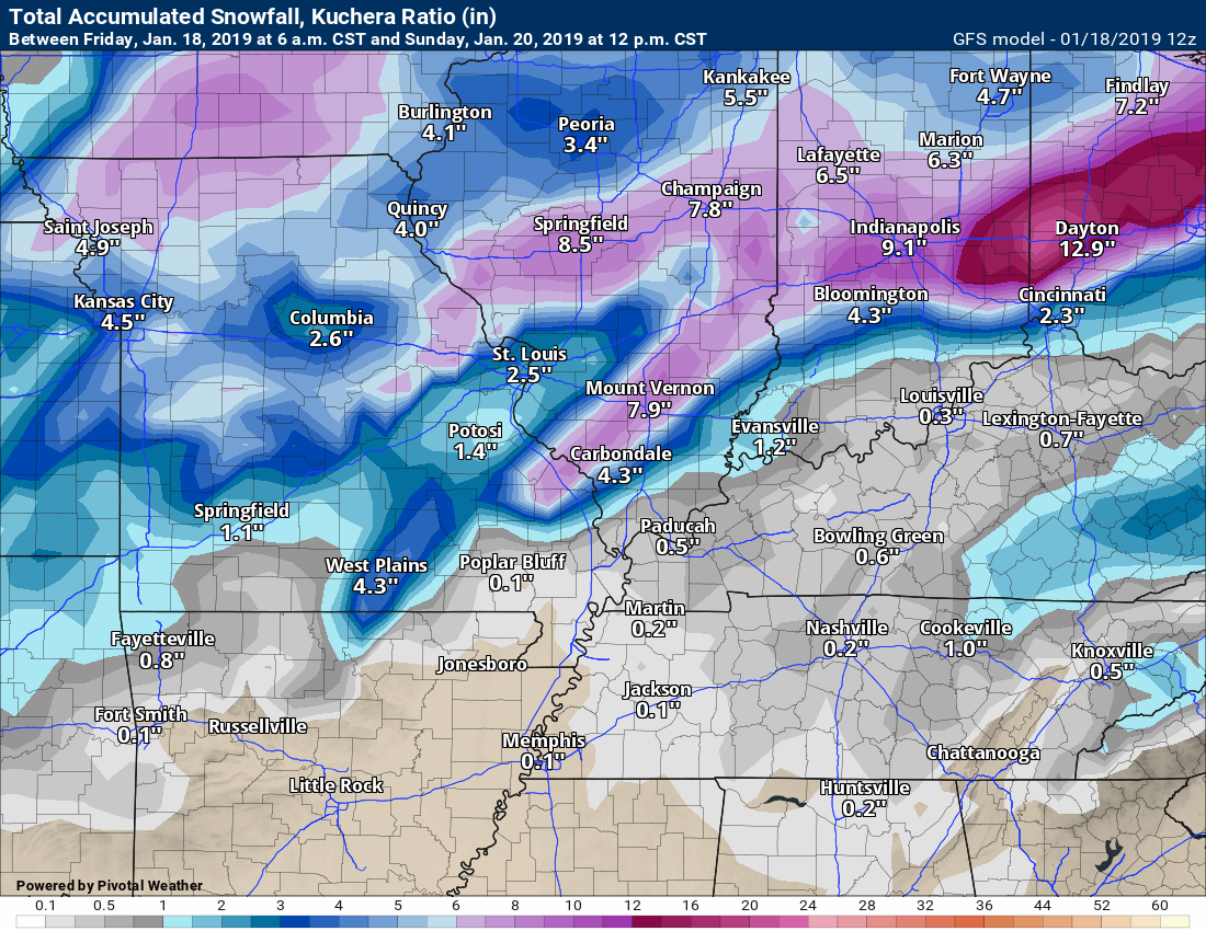
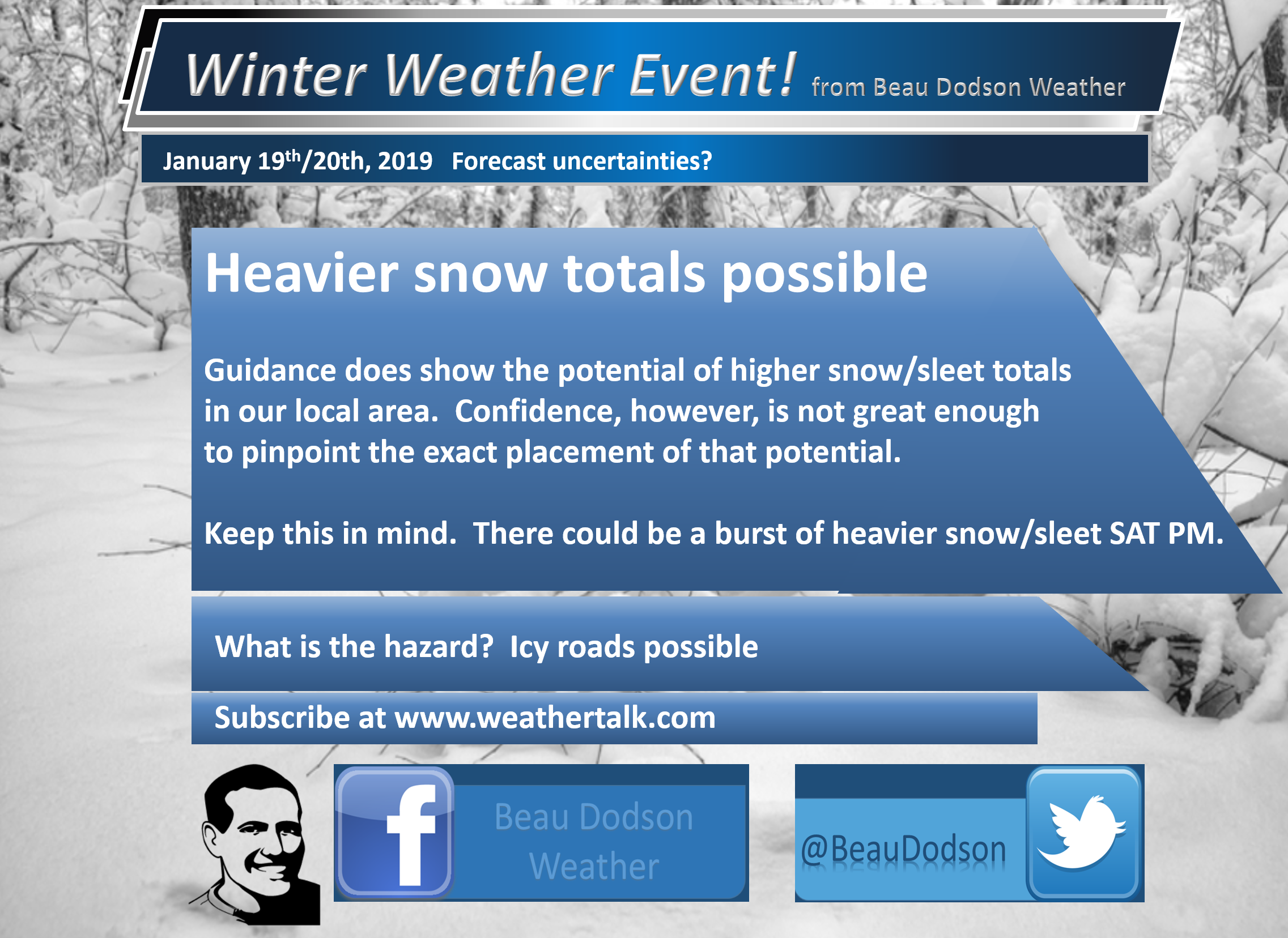
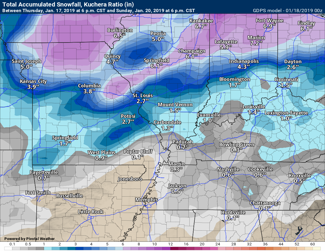
There could be a band of heavier snow totals about 30 to 40 miles wide. The placement of that band is uncertain but I hit parts of southeast MO and southern IL with the greatest chance of higher totals.
Generally, this is a widespread trace to two-inch snow event. Pockets of three and higher likely.
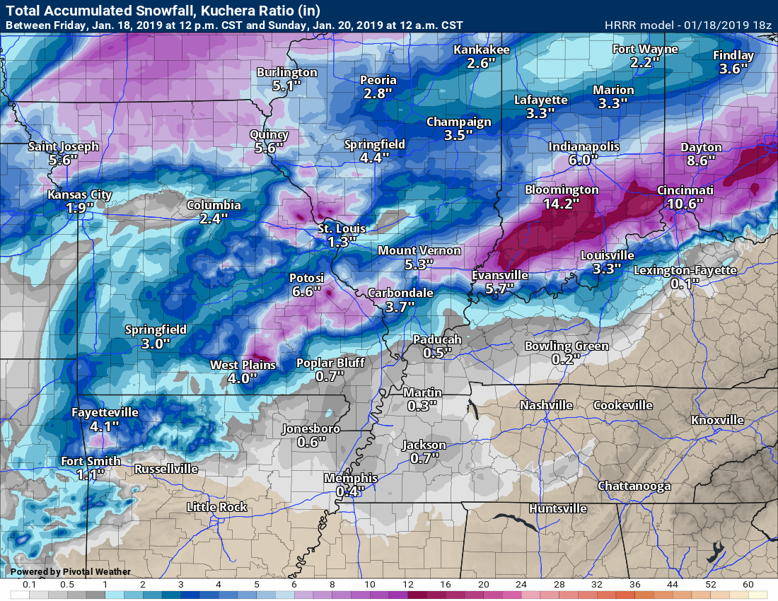
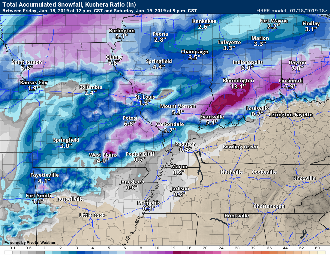
Here is the latest Hrrr model guidance.
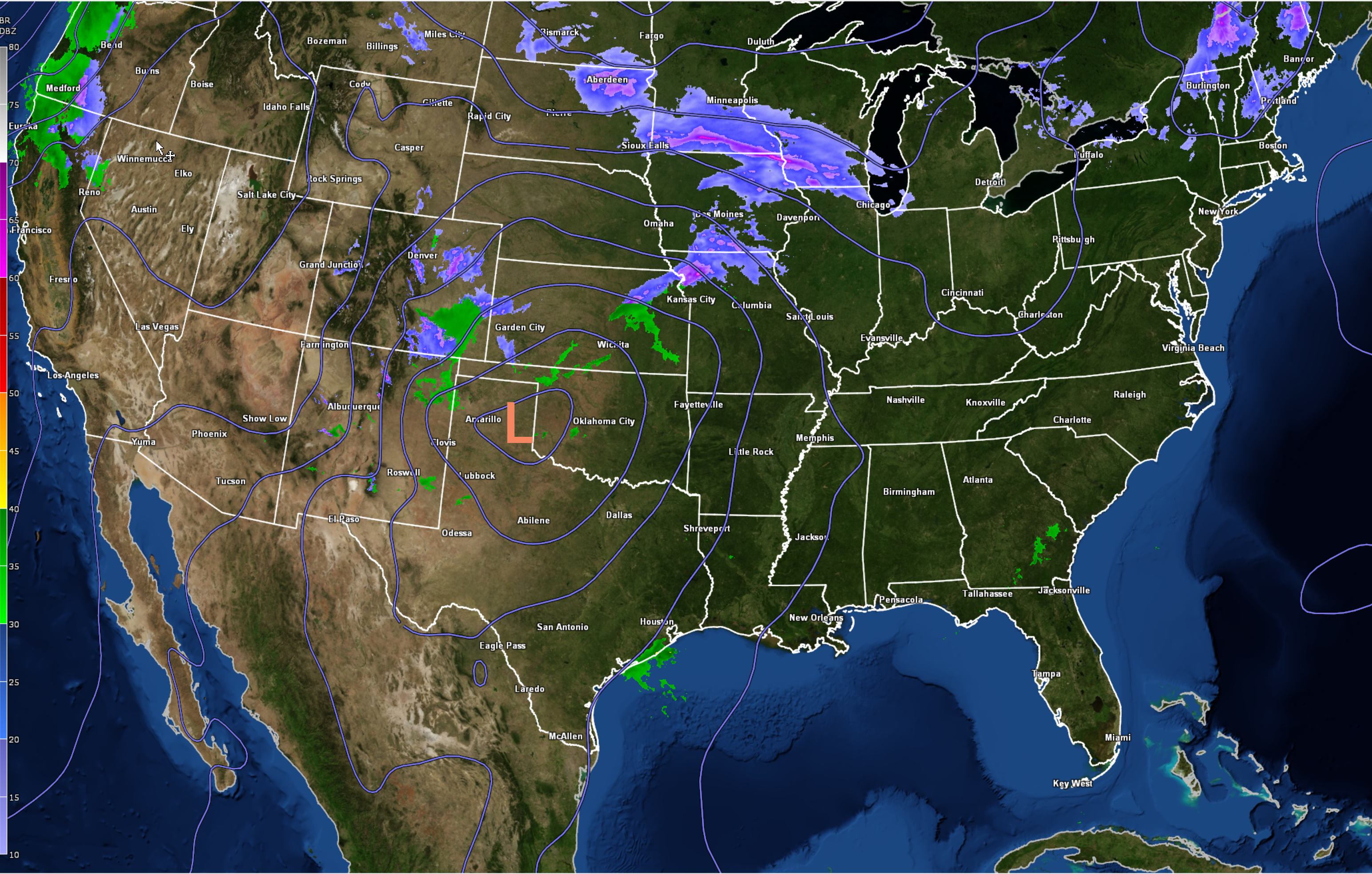
You can see the precip moving in over the coming hours. Green is rain. Yellow is moderate rain. Blue is snow. Dark blue is moderate to heavy snow. Purple and red are a wintry mix.
See the red L? That is the low.
The track of the L is key to snow amounts. The further north it tracks the further the snow will track.

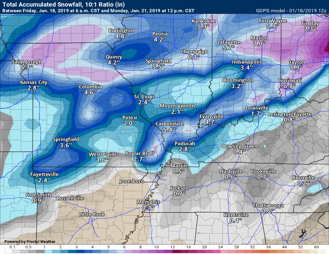
Hrrr snow totals
One model of many. Models are keying in on SE MO and south IL.
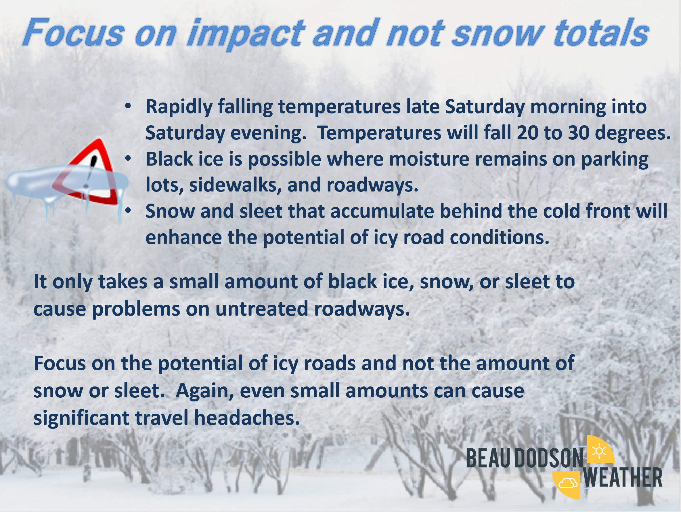
Focus on impact and not totals. The impact will be black ice and icy roads.
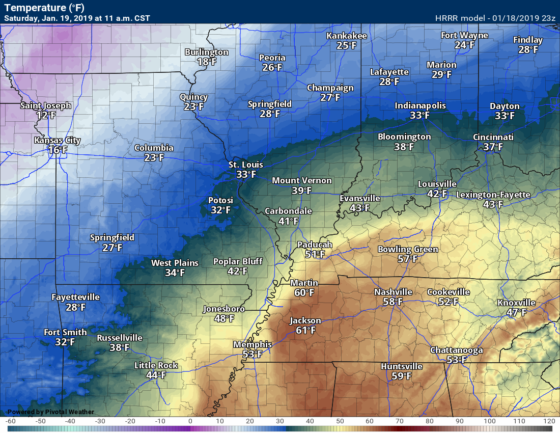
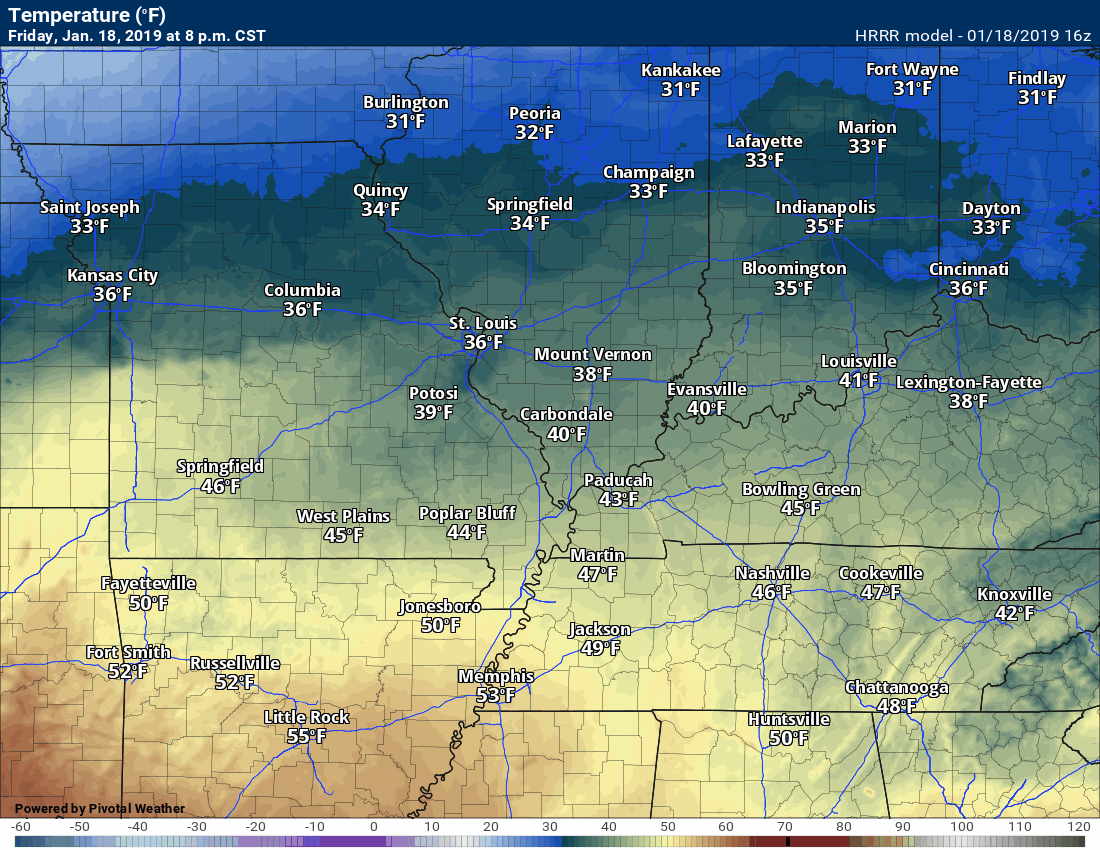
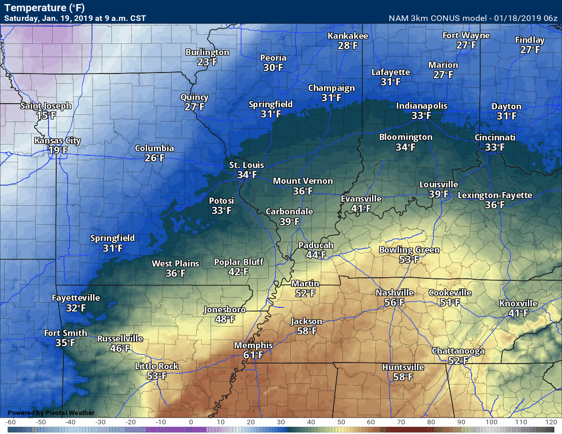
Here is the 11 AM temperature forecast map. Check out the large temperature gradient in our local area.
Impressive.
This is approximate. Sometimes these events can speed up. Keep this in mind.
Use this is a general idea of when precip could change to freezing rain, sleet, and/or snow.
Temperatures tonight will rise. That is because of warm and moist air streaming northward from the Gulf of Mexico.
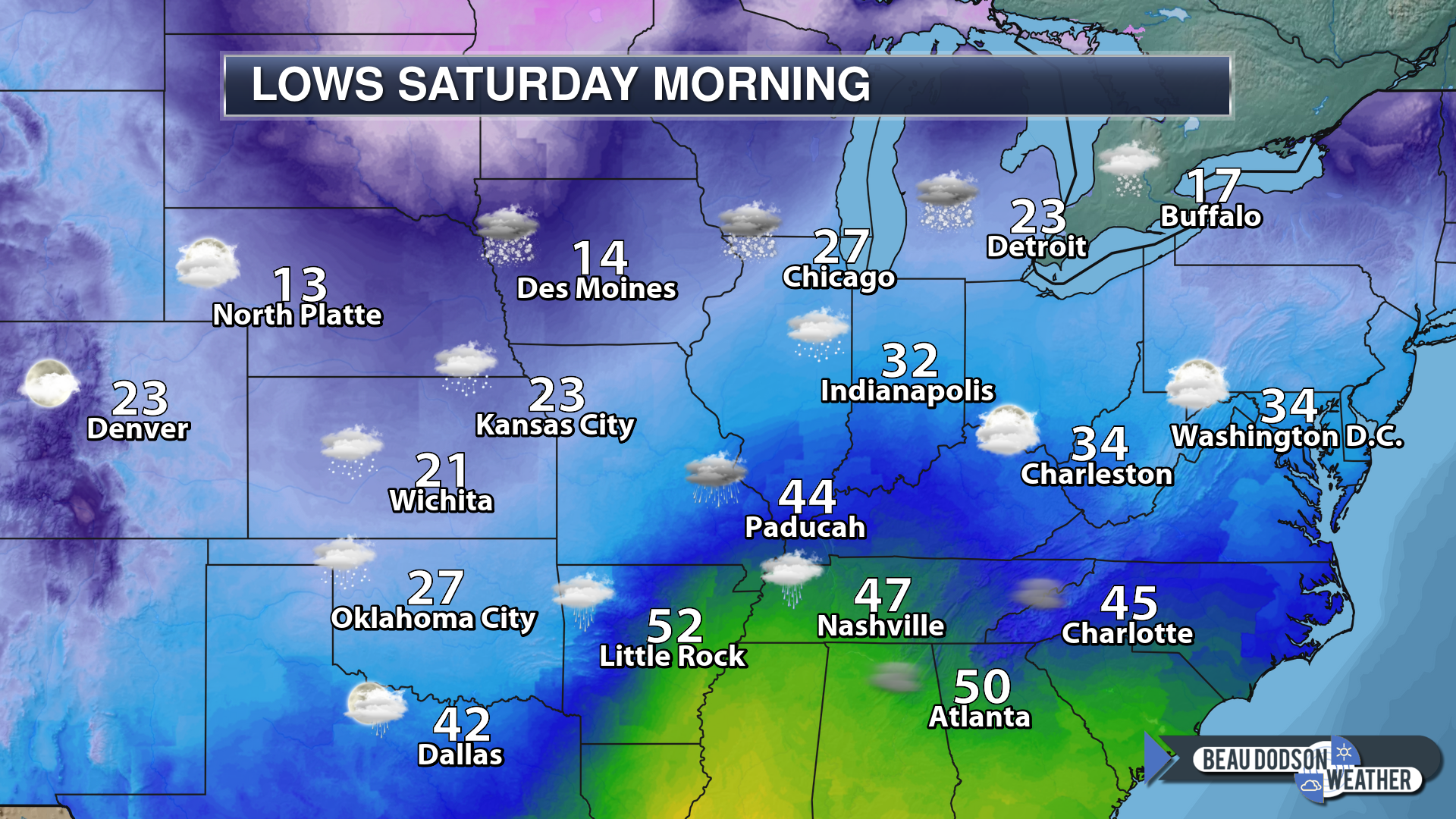
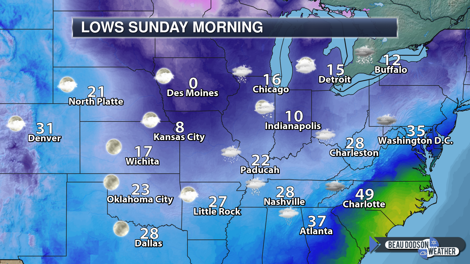
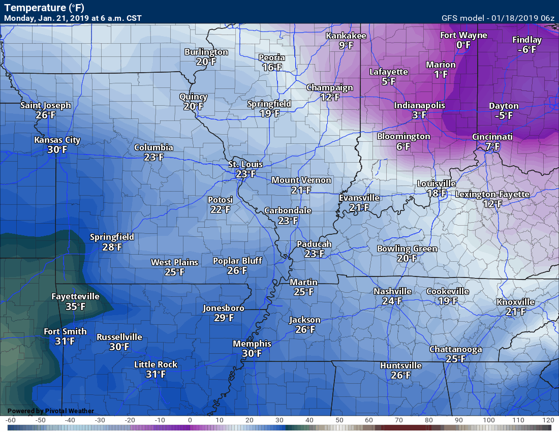
Check out the Sunday morning lows
Some areas will be in the teens
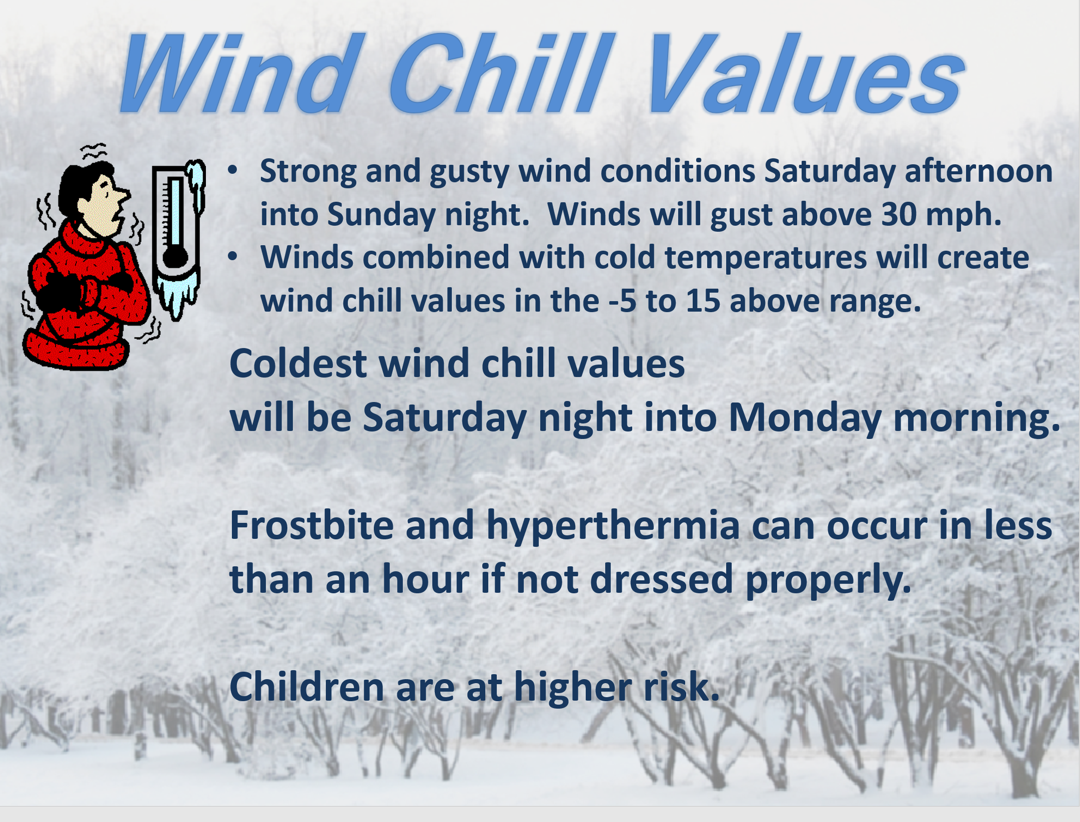
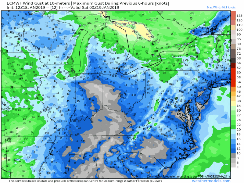
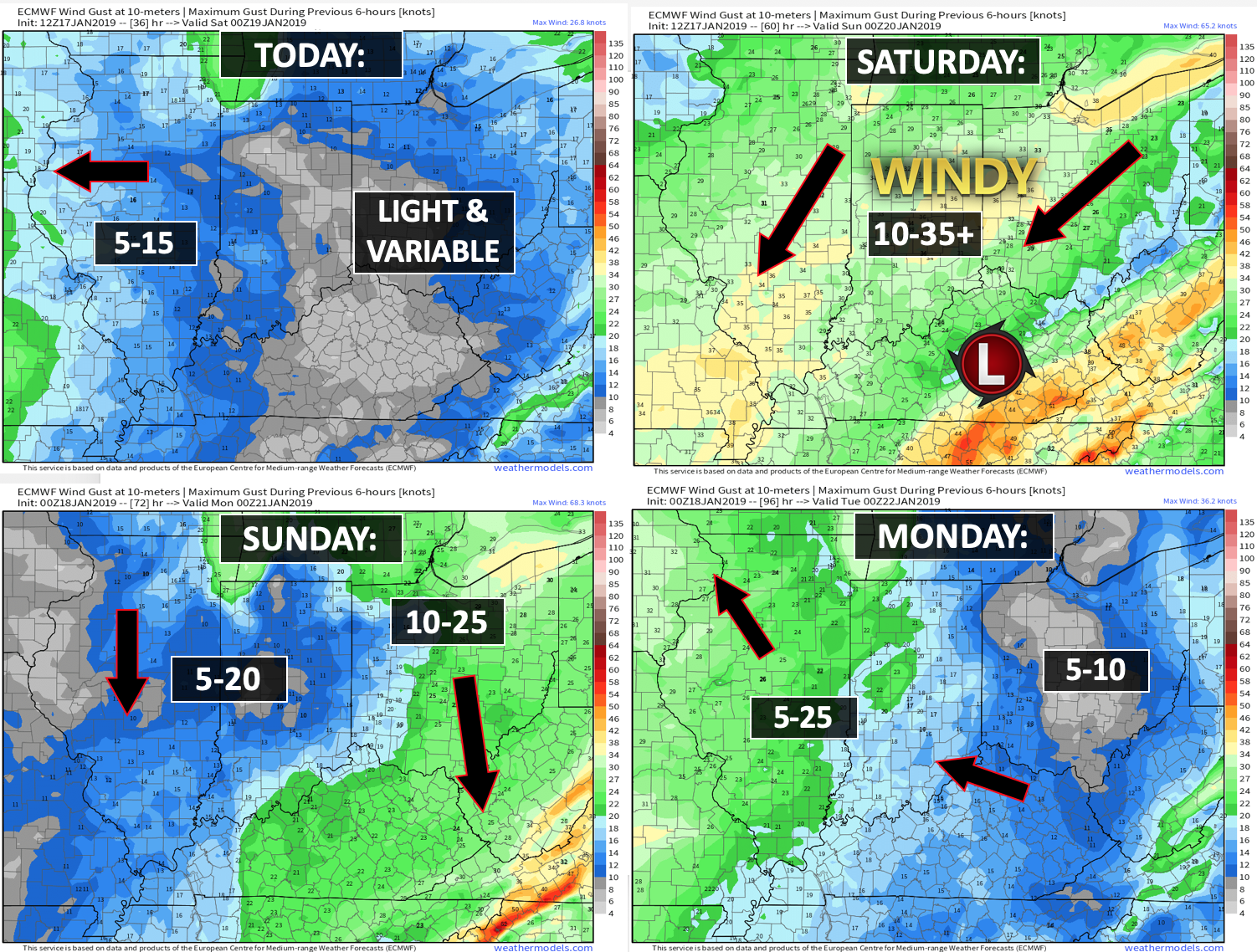
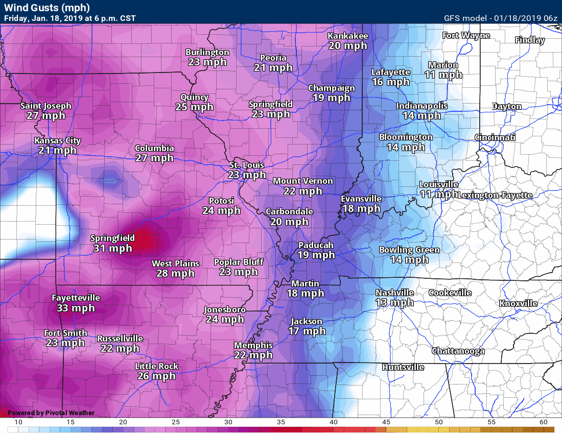
Wind gust map. Strong and gusty winds will develop over the next 24 hours. Some areas will top 40 mph.


7 PM
Updating all the graphics
Monitor
4 PM
Check out the wind gust map forecast.
If snow does accumulate then blowing snow will be a concern (not for all but for some)
The video team has posted a fresh video
3:10 PM
I am crunching new data.
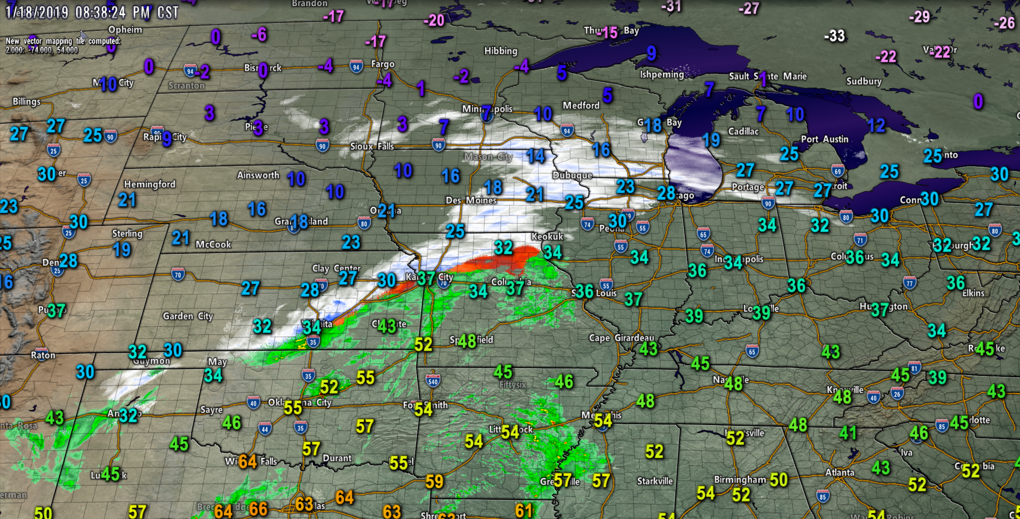
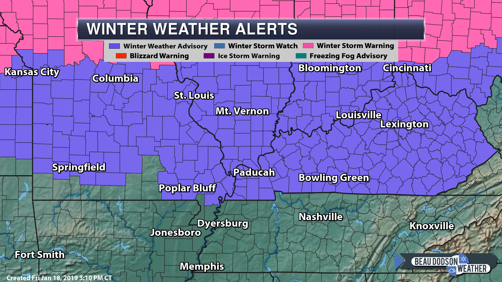
1/18/2019 Our winter storm is coming together. You can see the low out west. Radar will blossom over the next 12 hours. Official warnings and advisories are the last map. NWS has now issued an official advisory, as well.
I had a winter weather alert for us last night already for tomorrow into Sunday morning.
Now, the NWS has issued an official advisory for tomorrow afternoon into Sunday morning.
Here are those.
1:35 PM
I am waiting for the afternoon data to roll in before updating my graphics.
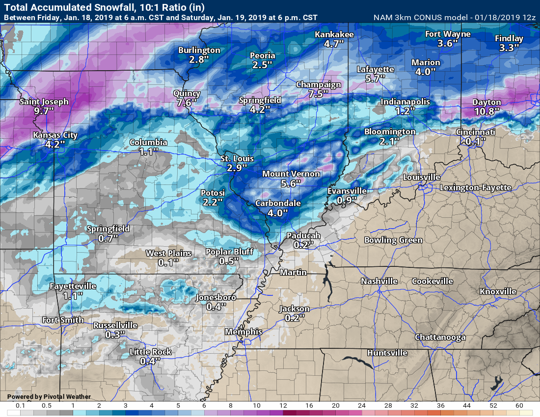
Here is the latest Hrrr future-cast radar and snow totals.
Again, one model of many. No models agree.
I will post more around 3:30 or 4 PM. Full update then.
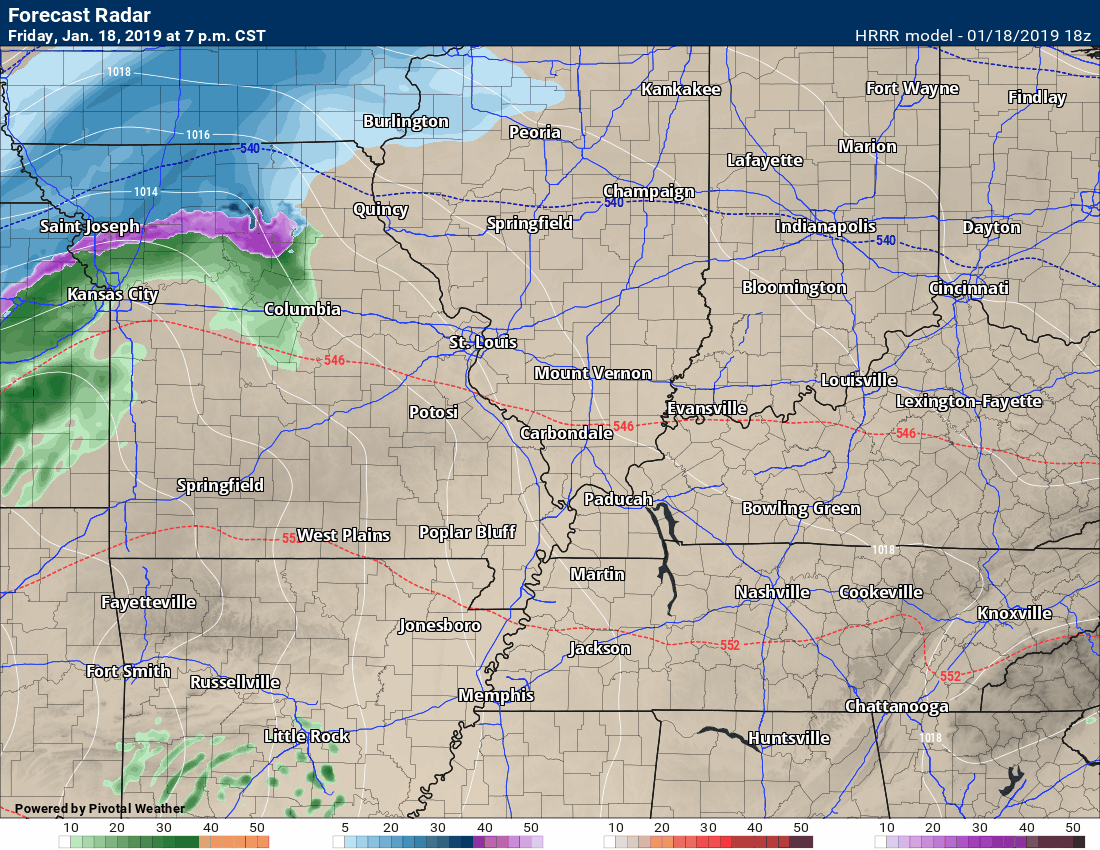
Again, take these numbers with a grain of salt. Models range from 0″ to 10″+ across the region.
12:15 PM
Hrrr model guidance future-cast radar.
This does not go out very far in time and only captures a portion of the event.
Timestamp upper left
Click to enlarge
Here is the temp animation.
You can see the cold air advancing south and east with time.
11 AM
I have a winter weather alert for the area tomorrow afternoon into Sunday morning.
Icy road conditions are possible.
Several inches of snow and sleet are likely to occur across the area.
There remain significant questions about the placement of the accumulating snow.
Blowing snow will cause lower visibility.
Officially, the NWS has not issued any advisories or watches/warnings.
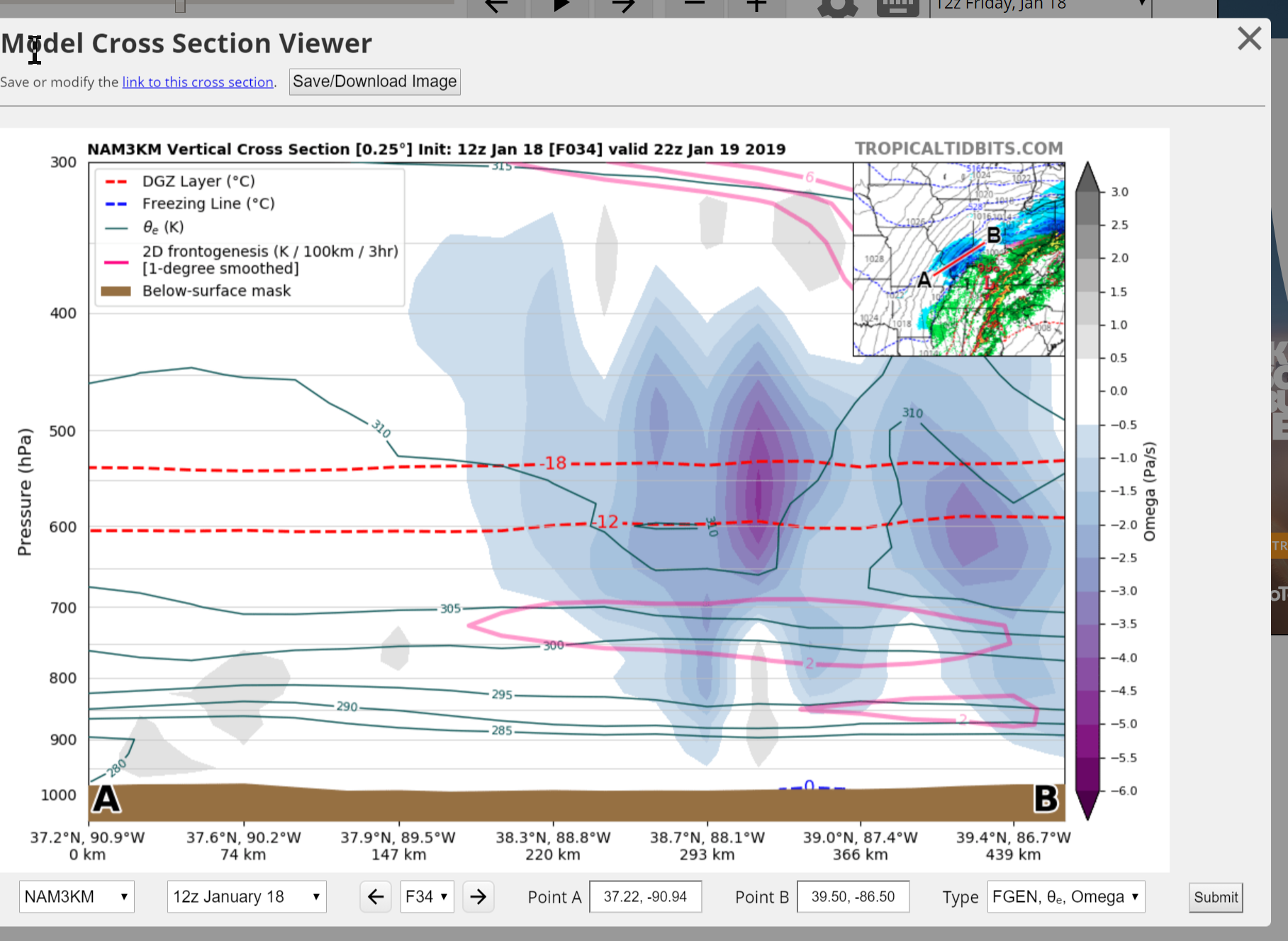
Here is a cross section of southern Illinois tomorrow afternoon.
This indicates the potential of heavy snow. Those purple colors between the dotted red line indicate nice snow growth. Flakes.
Locally heavy snow is increasingly likely in the area.
Here is the morning run of the Canadian model guidance.
You can see that it paints snow (blue) across our region Saturday afternoon and evening.
The Canadian model guidance is on-board with the idea of accumulating snow across our local area.
Again, this is one model’s idea. All the models vary in what they are showing.
I took a blend of model data to make my forecast (scroll further down for those graphics)
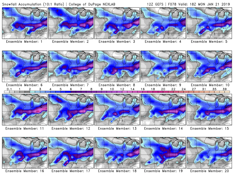
Here is the morning GFS ensembles snow forecast.
Notice that finger of snow in our area? That is what I have been monitoring and forecasting over the last few days.
The placement and intensity of it have varied.
I am also closely watching Tuesday night into Wednesday. Another winter storm may impact the region.
10 AM update
Here is the latest GFS model animation.
This is the future-cast radar.
Green and yellow would be rain. Blue is snow. Purple and pink are a wintry mix.
GFS shows heavy snow across parts of the area.
Again, take these numbers with a grain of salt. Models range from 0″ to 10″+ across the region.
Focus more on impact. Some icy road conditions are possible Saturday afternoon into Sunday morning.


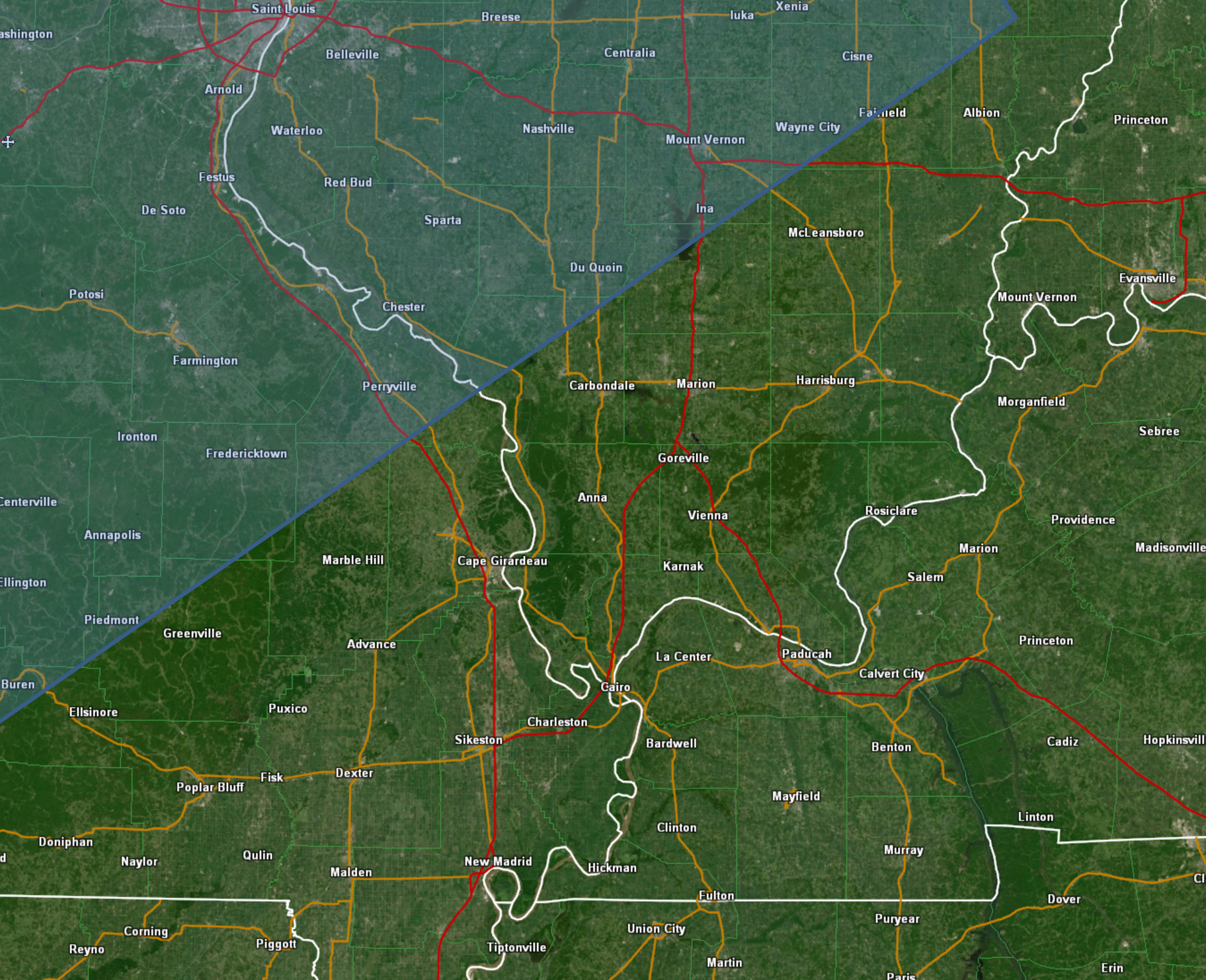
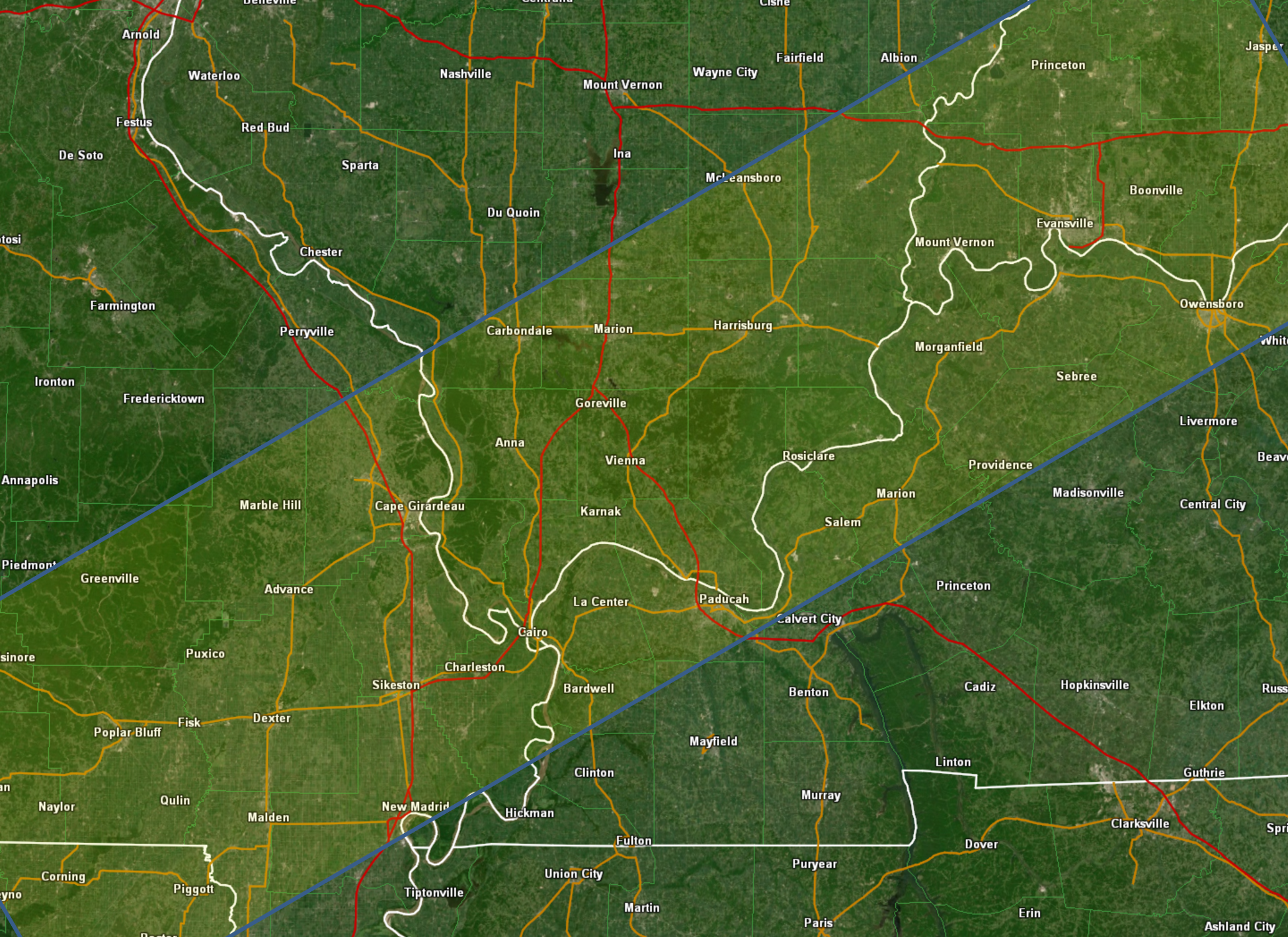
Click here for your interactive local city-view radars & regional radars.
During winter weather be sure and click the winterize button above each city-view radar. This will show you the precipitation type.
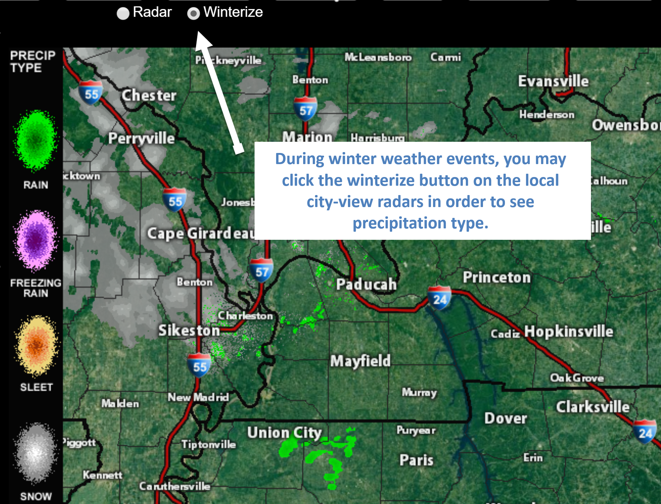
Click to enlarge this example of how to winterize your city-view radar.
You will also find clickable warning and advisory buttons.
If the radar is not updating then try another one. If a radar does not appear to be refreshing then hit Ctrl F5. You may also try restarting your browser.
Broken links? Something not working? Email me at beaudodson@usawx.com
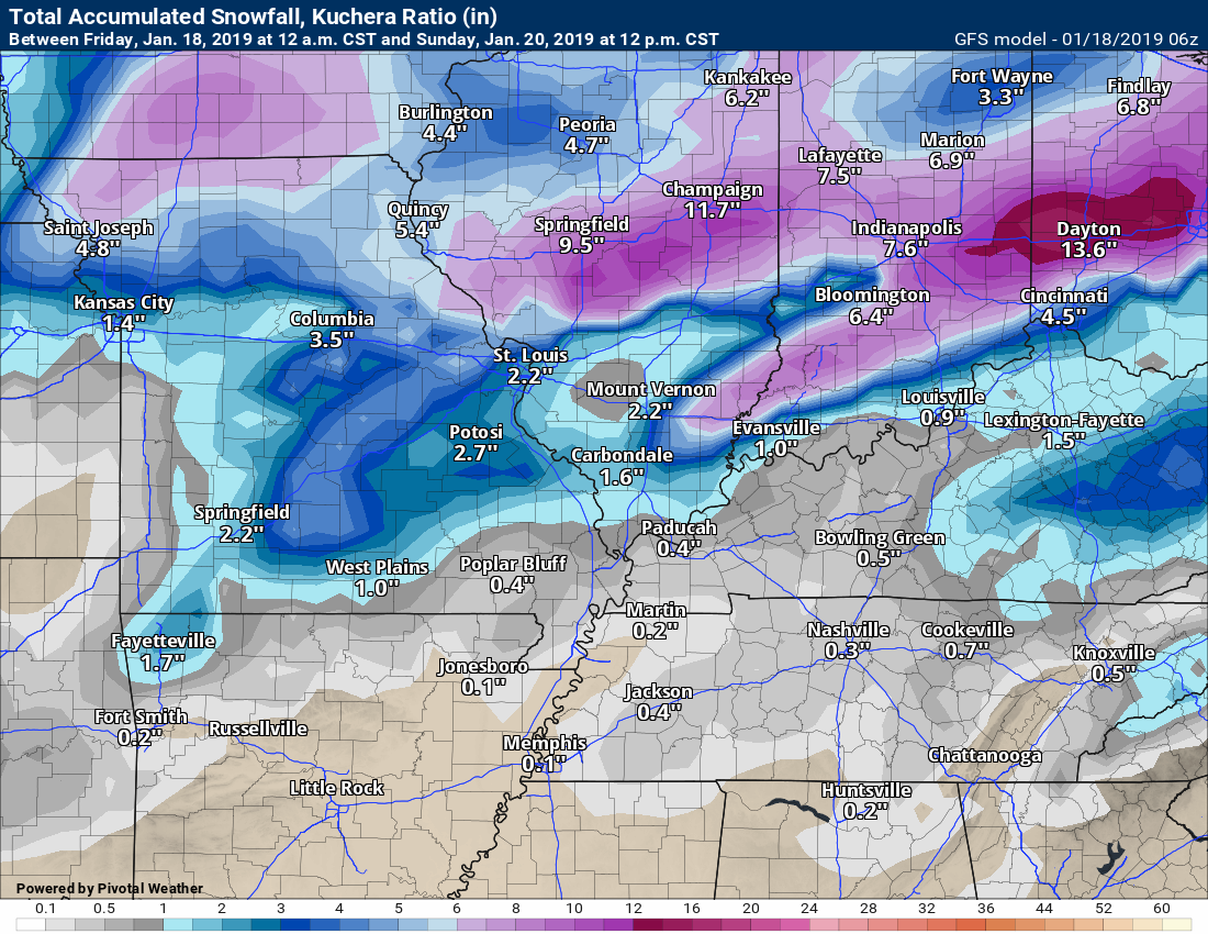
Models range from 0″ to 10″ of snow.
That gives you an idea of how poorly the model guidance is handling this event. I have no confidence in the model guidance.
Low confidence in snow totals. Some areas may receive very little in the way of wintry precipitation. Again, focus more on the potential of rapidly falling temperatures and some black ice on surfaces.

Several items of interest in the long range portion of the forecast.
- Widespread rain event tonight into Saturday.
- A winter storm event is possible Saturday afternoon and night
- Flash freeze likely Saturday afternoon and night. That means rapidly falling temperatures while moisture remains on roadways. Whether the strong winds will dry the roads is questionable. If the road surfaces do not dry then icy spots are likely to develop.
- Another precipitation event arrives Tuesday and Wednesday. Monitoring Thursday and Friday, as well.
Is today or tomorrow an action weather day? Yes. Saturday afternoon/night will be a weather action day. Monitor updates. I will be live blogging today into tomorrow.
What is an action weather day? It is a day when you need to monitor the forecast a bit closer. Inclement weather could impact your plans.
![]()
Key Message
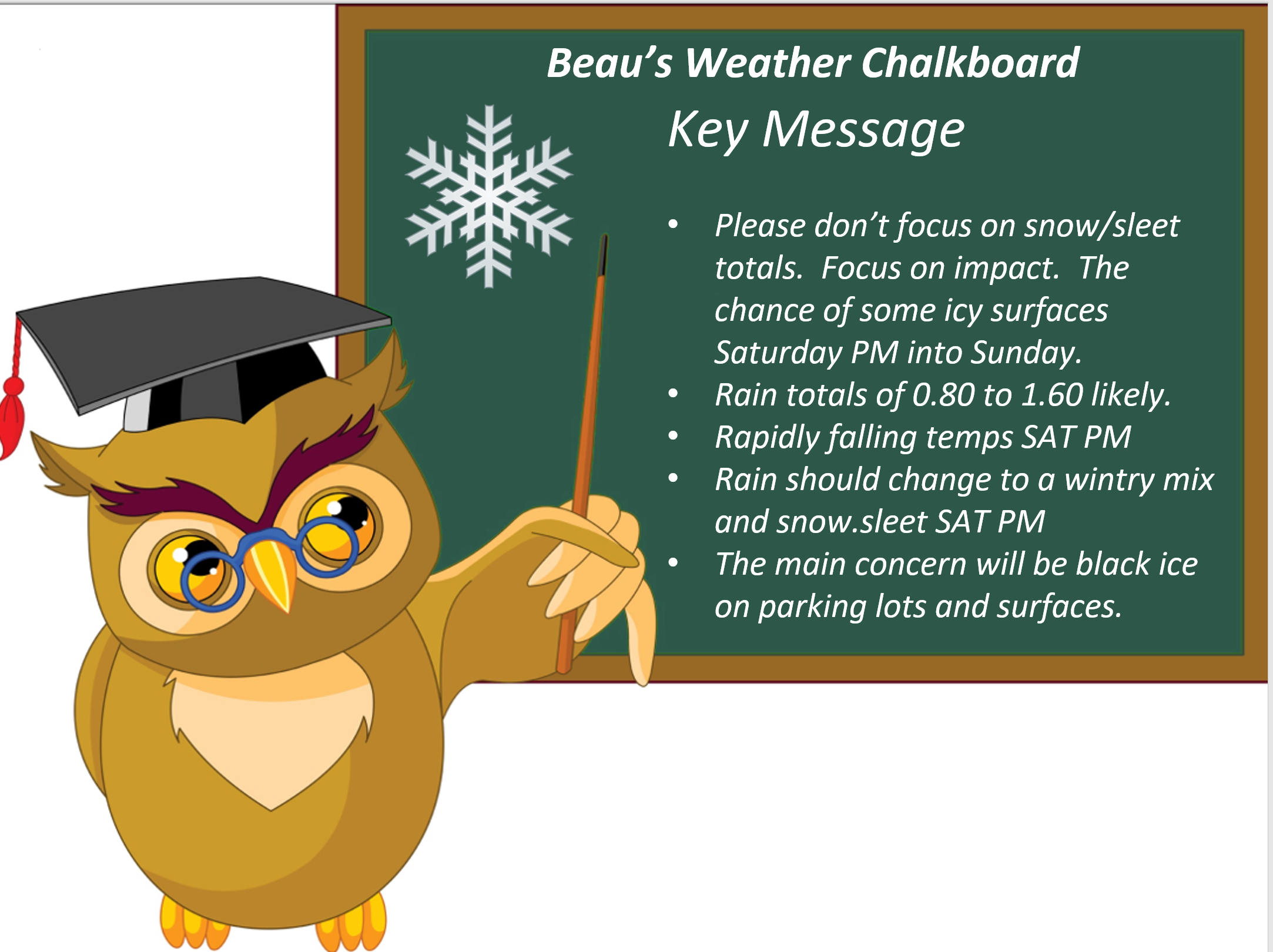
- I will be live blogging today. Come back to this page and check for updates on the latest guidance.
- Please don’t focus on snow totals. The main concern will be some icy surfaces as temperatures rapidly fall behind the cold front.
- Icy road concerns increase as temperatures fall Saturday afternoon and night. Black ice is possible on parking lots, sidewalks, and some roadways.
- IF snow/sleet falls behind the cold front then the icy road concerns increase significantly.
- Some snow/sleet accumulation is possible but confidence in totals remains low.
January 18, 2019
Friday’s Forecast: Increasing clouds.
My confidence in the forecast verifying: High (90% confidence in the forecast)
Temperature range: MO Bootheel 45° to 50° SE MO 40° to 45° South IL 38° to 45° West KY 48° to 52° NW TN 48° to 52°
Wind direction and speed: Variable at 5 to 10 mph with gusts to 14
Wind chill or heat index (feels like) temperature forecast: 40° to 50°
What is the chance/probability of precipitation? MO Bootheel 10% MO 10% IL 0% KY 0% TN 0%
Note: A 20% chance of rain does not mean it won’t rain. It simply means most areas will remain dry.
Coverage of precipitation: None to isolated
Is flash flooding anticipated? No
Will there be accumulating snow or ice? No
Will non-accumulating snow or ice occur? No
Are icy road conditions anticipated? No
Is severe weather expected? No
The NWS officially defines severe weather as 58 mph wind or great, 1″ hail or larger, and/or tornadoes
Is lightning anticipated? Not at this time
What impacts are anticipated from the weather? Most likely none
Should I cancel my outdoor plans? No
UV Index: 1 to 2 Low
Sunrise: 7:08 AM
** Note: Please, do me a favor. Log into your www.weathertalk.com account and make sure it does not say free. We have quite a few expired accounts. You would still be receiving app/text messages even if your account credit card/PayPal expired. I have to manually shut them off. I appreciate it. Thank you. **
Friday Night Forecast Details:
Forecast: Becoming cloudy with rain likely. Rain could mix with sleet and snow over my northern counties (Perry County, MO towards Carmi, IL). Monitor updates. Confidence in the rain/snow line is low.
My confidence in the forecast verifying: High (90% confidence in the forecast)
Temperature range: MO Bootheel 44° to 48° SE MO 35° to 40° South IL 34° to 40° West KY 44° to 48° NW TN 44° to 48°
Wind direction and speed: Variable at 5 to 10 mph with gusts to 14 becoming gustier as the night wears on
Wind chill or heat index (feels like) temperature forecast: 30° to 40°
What is the chance/probability of precipitation? MO Bootheel 80% MO 80% IL 80% KY 80% TN 80%
Note: A 20% chance of rain does not mean it won’t rain. It simply means most areas will remain dry.
Coverage of precipitation: Increasing coverage. Becoming numerous.
Is flash flooding anticipated? No
Will there be accumulating snow or ice? Monitor over my far NW counties
Will non-accumulating snow or ice occur? Monitor over my far NW counties
Are icy road conditions anticipated? Monitor over my far NW counties
Is severe weather expected? No
The NWS officially defines severe weather as 58 mph wind or great, 1″ hail or larger, and/or tornadoes
Is lightning anticipated? Not at this time
What impacts are anticipated from the weather? Wet roadways. Monitor updates concerning wintry precipitation, as well.
Should I cancel my outdoor plans? Have a plan B.
Sunset: 5:04 PM
Moonrise: 2:38 PM
The phase of the moon: Waxing Gibbous
Moonset: 4:23 AM
January 19, 2019
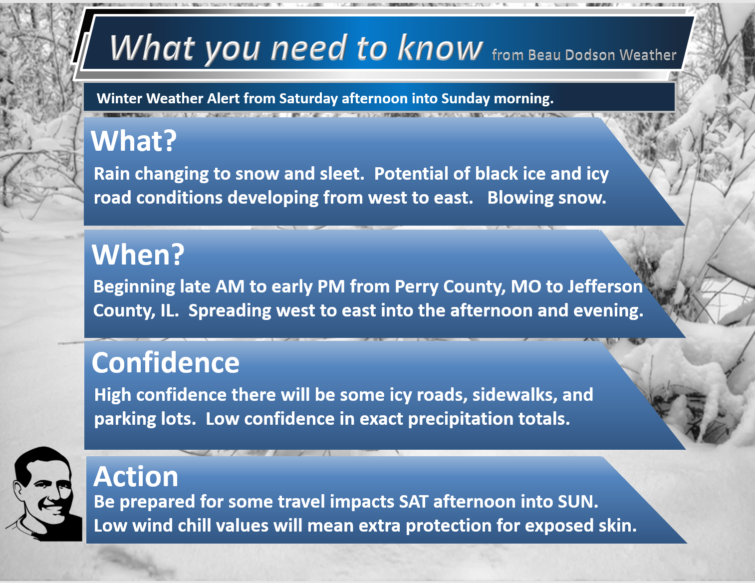
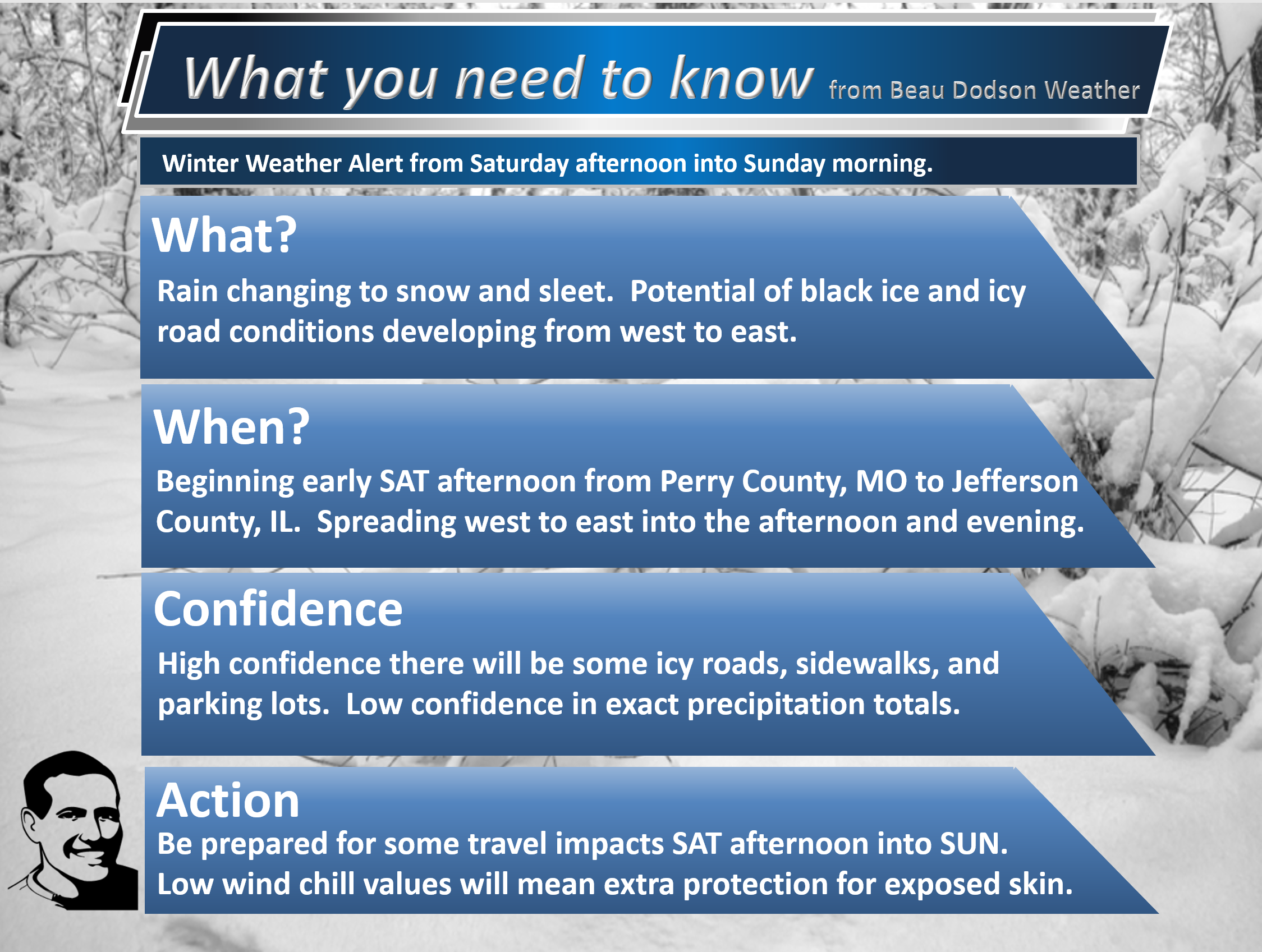
Winter weather alert Saturday afternoon and night.
Low confidence in how much snow/sleet accumulation occurs with this event.
Focus on impact and NOT totals. There could be snow/sleet accumulation but the main concern will be rapidly falling temperatures with moisture remaining on roads and surfaces. That could cause black ice.
Saturday’s Forecast: Intervals of rain. Increasing winds. Rain changing to freezing rain, sleet, and snow mainly during the afternoon hours. Some accumulation possible. Monitor updated forecast information. Blizzard or near blizzard conditions are possible with blowing and drifting snow. A band of three to six inches likely somewhere in the region. Pay attention to updates. A wide range of temperatures as an arctic cold front moves through the region. Temperatures will fall sharply behind the frontal system. A flash freeze is likely behind the cold front.
My confidence in the forecast verifying: Medium (60% confidence in the forecast)
Temperature range: MO Bootheel 48° to 54° SE MO 35° to 45° South IL 35° to 48° West KY 46° to 52° NW TN 50° to 55°
Wind direction and speed: Southwest becoming west and northwest at 15 to 30 mph and gusty
Wind chill or heat index (feels like) temperature forecast: 10° to 30°
What is the chance/probability of precipitation? MO Bootheel 100% MO 100% IL 100% KY 100% TN 100%
Note: A 20% chance of rain does not mean it won’t rain. It simply means most areas will remain dry.
Coverage of precipitation: Widespread
Is flash flooding anticipated? No.
Will there be accumulating snow or ice? Yes. Several inches of snow will be possible in the snow band. Monitor updates on the placement of the greatest risk of accumulating snow. Blizzard or near blizzard conditions are possible with blowing and drifting snow. A band of three to six inches likely somewhere in the region. Pay attention to updates.
Will non-accumulating snow or ice occur? Yes
Are icy road conditions anticipated? Yes. Icy roads may develop from west to east across the region.
Is severe weather expected? No
The NWS officially defines severe weather as 58 mph wind or great, 1″ hail or larger, and/or tornadoes
Is lightning anticipated? Small risk of lightning in south-central Kentucky and western Tennessee.
What impacts are anticipated from the weather? Wet roadways. Monitor the chance of icy road conditions. Strong and gusty winds developing.
Should I cancel my outdoor plans? Have a plan B.
UV Index: 1 Low
Sunrise: 7:07 AM
Saturday Night Forecast Details:
Winter weather alert Saturday afternoon and night.
Forecast: Windy. Sharply colder. A chance of snow. Some accumulation possible. Blowing snow possible. Black ice is likely in parking lots and on surfaces that didn’t have time to dry off behind the cold front. Blizzard or near blizzard conditions are possible with blowing and drifting snow. A band of three to six inches likely somewhere in the region. Pay attention to updates.
My confidence in the forecast verifying: Medium (50% confidence in the forecast)
Temperature range: MO Bootheel 18° to 24° SE MO 16° to 22° South IL 16° to 22° West KY 20° to 25° NW TN 25° to 30°
Wind direction and speed: Becoming northwest and north at 15 to 30 mph with gusts to 40 mph
Wind chill or heat index (feels like) temperature forecast: 0° to 10°
What is the chance/probability of precipitation? MO Bootheel 60% MO 50% IL 50% KY 60% TN 60%
Note: A 20% chance of rain does not mean it won’t rain. It simply means most areas will remain dry.
Coverage of precipitation: Scattered to perhaps numerous. Monitor updates.
Is flash flooding anticipated? No
Will there be accumulating snow or ice? Yes. Several inches of snow will be possible in the snow band. Monitor updates on the placement of the greatest risk of accumulating snow.
Will non-accumulating snow or ice occur? Yes
Are icy road conditions anticipated? Yes
Is severe weather expected? No
The NWS officially defines severe weather as 58 mph wind or great, 1″ hail or larger, and/or tornadoes
Is lightning anticipated? No
What impacts are anticipated from the weather? Icy roads. Blowing snow. Lower visibility in areas that have blowing snow. Bitterly cold wind chill values.
Should I cancel my outdoor plans? Have a plan B because of possible precipitation and temperatures being so cold.
Sunset: 5:05 PM
Moonrise: 3:37 PM
The phase of the moon: Waxing Gibbous
Moonset: 5:30 AM
January 20, 2019
Sunday’s Forecast: Cloudy. Windy. Colder. Low wind chill values. Snow showers possible.
My confidence in the forecast verifying: Medium (60% confidence in the forecast)
Temperature range: MO Bootheel 26° to 28° SE MO 24° to 28° South IL 24° to 26° West KY 24° to 26° NW TN 25° to 30°
Wind direction and speed: North at 15 to 30 mph and gusty.
Wind chill or heat index (feels like) temperature forecast: 10° to 15°
What is the chance/probability of precipitation? MO Bootheel 20% MO 20% IL 30% KY 30% TN 20%
Note: A 20% chance of rain does not mean it won’t rain. It simply means most areas will remain dry.
Coverage of precipitation: Patchy
Is flash flooding anticipated? No
Will there be accumulating snow or ice? Monitor
Will non-accumulating snow or ice occur? Possible
Are icy road conditions anticipated? Yes
Is severe weather expected? No
The NWS officially defines severe weather as 58 mph wind or great, 1″ hail or larger, and/or tornadoes
Is lightning anticipated? No
What impacts are anticipated from the weather? Icy roads. Blowing snow in some areas. Black ice. Bitterly cold wind chill values.
Should I cancel my outdoor plans? Have a plan B.
UV Index: 1 Low
Sunrise: 7:07 AM
Sunday Night Forecast Details:
Forecast: Clearing for the lunar eclipse. Bitterly cold. Low wind chill values. Temperatures will vary based on snow cover and clearing. If sky conditions clear then temperatures would be colder over a snow-pack. Still some questions on the chance of snow.
My confidence in the forecast verifying: Medium (60% confidence in the forecast)
Temperature range: MO Bootheel 16° to 18° SE MO 14° to 18° South IL 14° to 18° West KY 14° to 18° NW TN 18° to 24°
Wind direction and speed: North and northwest at 6 to 12 mph with gusts to 30 mph
Wind chill or heat index (feels like) temperature forecast: 0° to 15°
What is the chance/probability of precipitation? MO Bootheel 0% MO 0% IL 0% KY 0% TN 0%
Note: A 20% chance of rain does not mean it won’t rain. It simply means most areas will remain dry.
Coverage of precipitation: None
Is flash flooding anticipated? No
Will there be accumulating snow or ice? No
Will non-accumulating snow or ice occur? No
Are icy road conditions anticipated? Monitor the chance of icy road conditions. A bit early for certainties.
Is severe weather expected? No
The NWS officially defines severe weather as 58 mph wind or great, 1″ hail or larger, and/or tornadoes
Is lightning anticipated? No
What impacts are anticipated from the weather? Low wind chill values. Icy roads may remain in some areas.
Should I cancel my outdoor plans? It will not be uncomfortable outside. Have a plan B. Monitor the potential of icy roadways remaining.
Sunset: 5:06 PM
Moonrise: 4:43 PM
The phase of the moon: Full moon
Moonset: 6:34 AM
![]()
January 21, 2019
Monday’s Forecast: Partly cloudy and cold.
My confidence in the forecast verifying: High (80% confidence in the forecast)
Temperature range: MO Bootheel 32° to 35° SE MO 32° to 36° South IL 32° to 36° West KY 34° to 38° NW TN 35° to 38°
Wind direction and speed: Variable winds becoming east at 6 to 12 mph and gusty
Wind chill or heat index (feels like) temperature forecast: 15° to 30°
What is the chance/probability of precipitation? MO Bootheel 0% MO 0% IL 0% KY 0% TN 0%
Note: A 20% chance of rain does not mean it won’t rain. It simply means most areas will remain dry.
Coverage of precipitation: None
Is flash flooding anticipated? No
Will there be accumulating snow or ice? No
Will non-accumulating snow or ice occur? No
Are icy road conditions anticipated? Monitor the chance of icy road conditions. This will depend on what happens Saturday into Sunday.
Is severe weather expected? No
The NWS officially defines severe weather as 58 mph wind or great, 1″ hail or larger, and/or tornadoes
Is lightning anticipated? No
What impacts are anticipated from the weather? Cold air. Monitor the potential of icy roadways remaining.
Should I cancel my outdoor plans? No, but it will be cold.
UV Index: 2 Low
Sunrise: 7:06 AM
Monday Night Forecast Details:
Forecast: A few clouds. Patchy fog.
My confidence in the forecast verifying: High (70% confidence in the forecast)
Temperature range: MO Bootheel 24° to 28° SE MO 24° to 28° South IL 24° to 28° West KY 24° to 28° NW TN 26° to 30°
Wind direction and speed: Southeast at 8 to 16 mph and gusty
Wind chill or heat index (feels like) temperature forecast: 8° to 18°
What is the chance/probability of precipitation? MO Bootheel 0% MO 0% IL 0% KY 0% TN 0%
Note: A 20% chance of rain does not mean it won’t rain. It simply means most areas will remain dry.
Coverage of precipitation: None
Is flash flooding anticipated? No
Will there be accumulating snow or ice? No
Will non-accumulating snow or ice occur? No
Are icy road conditions anticipated? No
Is severe weather expected? No
The NWS officially defines severe weather as 58 mph wind or great, 1″ hail or larger, and/or tornadoes
Is lightning anticipated? No
What impacts are anticipated from the weather? Lower visibility in fog.
Should I cancel my outdoor plans? No
Sunset: 5:06 PM
Moonrise: 4:43 PM
The phase of the moon: Waning Gibbous
Moonset: 7:34 AM
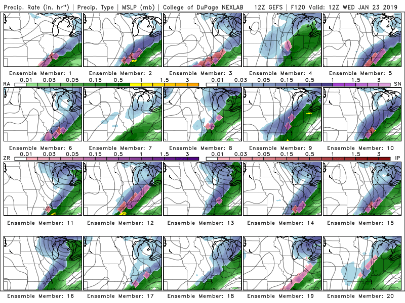
Another storm system moves into the region Tuesday and Wednesday.
As always, the track of the system will be key to whether we end up with rain, snow, sleet, or freezing rain (or all the above).
Monitor updates.
January 22, 2019
Tuesday’s Forecast: Increasing clouds. Showers developing. Breezy.
My confidence in the forecast verifying: Medium (50% confidence in the forecast)
Temperature range: MO Bootheel 44° to 46° SE MO 38° to 44° South IL 38° to 44° West KY 40° to 45° NW TN 42° to 45°
Wind direction and speed: East at 5 to 10 mph with gusts to 14
Wind chill or heat index (feels like) temperature forecast: 30° to 40°
What is the chance/probability of precipitation? MO Bootheel 50% MO 50% IL 50% KY 50% TN 50%
Note: A 20% chance of rain does not mean it won’t rain. It simply means most areas will remain dry.
Coverage of precipitation: Increasing. Becoming numerous.
Is flash flooding anticipated? No
Will there be accumulating snow or ice? No
Will non-accumulating snow or ice occur? No
Are icy road conditions anticipated? No
Is severe weather expected? No
The NWS officially defines severe weather as 58 mph wind or great, 1″ hail or larger, and/or tornadoes
Is lightning anticipated? No
What impacts are anticipated from the weather? Wet roadways
Should I cancel my outdoor plans? Have a plan B.
UV Index: 2 Low
Sunrise: 7:06 AM
Tuesday Night Forecast Details:
Forecast: Cloudy. Windy. Rain likely. Rain may mix with or change to a wintry mix and eventually snow.
My confidence in the forecast verifying: Medium (40% confidence in the forecast)
Temperature range: MO Bootheel 33° to 36° SE MO 32° to 35° South IL 32° to 35° West KY 32° to 35° NW TN 34° to 38°
Wind direction and speed: South becoming west and northwest at 15 to 30 mph and gusty.
Wind chill or heat index (feels like) temperature forecast: 5° to 15°
What is the chance/probability of precipitation? MO Bootheel 60% MO 60% IL 60% KY 60% TN 60%
Note: A 20% chance of rain does not mean it won’t rain. It simply means most areas will remain dry.
Coverage of precipitation: Numerous
Is flash flooding anticipated? No
Will there be accumulating snow or ice? Yes, it is possible.
Will non-accumulating snow or ice occur? Yes. Likely.
Are icy road conditions anticipated? Yes. Icy roads may redevelop.
Is severe weather expected? No
The NWS officially defines severe weather as 58 mph wind or great, 1″ hail or larger, and/or tornadoes
Is lightning anticipated? No
What impacts are anticipated from the weather? Wet roadways. Icy roadways. Windy conditions.
Should I cancel my outdoor plans? Have a plan B.
Sunset: 5:08 PM
Moonrise: 7:09 PM
The phase of the moon: Waning Gibbous
Moonset: 8:19 AM
January 23, 2019
Wednesday’s Forecast: Cloudy. A chance of morning snow. Colder. Breezy.
My confidence in the forecast verifying: Low (30% confidence in the forecast)
Temperature range: MO Bootheel 33° to 36° SE MO 30° to 35° South IL 30° to 35° West KY 32° to 36° NW TN 32° to 36°
Wind direction and speed: North and northwest at 7 to 14 mph with gusts to 25 mph
Wind chill or heat index (feels like) temperature forecast: 10° to 20°
What is the chance/probability of precipitation? MO Bootheel 30% MO 30% IL 30% KY 30% TN 30%
Note: A 20% chance of rain does not mean it won’t rain. It simply means most areas will remain dry.
Coverage of precipitation: Scattered and then ending.
Is flash flooding anticipated? No
Will there be accumulating snow or ice? Monitor
Will non-accumulating snow or ice occur? Monitor
Are icy road conditions anticipated? Monitor
Is severe weather expected? No
The NWS officially defines severe weather as 58 mph wind or great, 1″ hail or larger, and/or tornadoes
Is lightning anticipated? No
What impacts are anticipated from the weather? Perhaps icy roadways.
Should I cancel my outdoor plans? Have a plan B
UV Index: 1 Low
Sunrise: 7:05 AM
Wednesday Night Forecast Details:
Forecast: Cloudy with a chance of snow showers.
My confidence in the forecast verifying: Low (20% confidence in the forecast)
Temperature range: MO Bootheel 25° to 30° SE MO 20° to 25° South IL 20° to 25° West KY 22° to 26° NW TN 25° to 30°
Wind direction and speed: North at 7 to 14 mph
Wind chill or heat index (feels like) temperature forecast: 20° to 30°
What is the chance/probability of precipitation? MO Bootheel 20% MO 20% IL 20% KY 20% TN 20%
Note: A 20% chance of rain does not mean it won’t rain. It simply means most areas will remain dry.
Coverage of precipitation: Scattered
Is flash flooding anticipated? No
Will there be accumulating snow or ice? Possible
Will non-accumulating snow or ice occur? Yes
Are icy road conditions anticipated? Yes, icy roads are possible.
Is severe weather expected? No
The NWS officially defines severe weather as 58 mph wind or great, 1″ hail or larger, and/or tornadoes
Is lightning anticipated? No
What impacts are anticipated from the weather? Icy roads are possible.
Should I cancel my outdoor plans? Have a plan B and monitor updates.
Sunset: 5:09 PM
Moonrise: 8:21 PM
The phase of the moon: Waning Gibbous
Moonset: 9:02 AM
Learn more about the UV index readings. Click here.
The wind speed and direction forecast.
Strong and gusty wind conditions Saturday into Sunday. Gusts above 35 mph likely Saturday afternoon and night.
Friday, January 18th: Wintry precipitation is not anticipated during the day.
Friday night, January 18th: Wintry precipitation is not anticipated.
Saturday into Saturday night, January 19th: Rain changing to snow and a wintry mix. Some accumulation possible Saturday afternoon into Sunday morning. Follow updated forecasts moving forward. Confidence in snow accumulation is low.
Sunday, January 20th: Snow showers possible. Wind chill values will dip into the single digits.
Monday, January 21st: Wintry precipitation is not anticipated
Monday night into Tuesday: Precipitation will be likely. Rain may change to snow or a wintry mix Tuesday evening and night.
Wednesday, January 22nd: Snow showers possible.
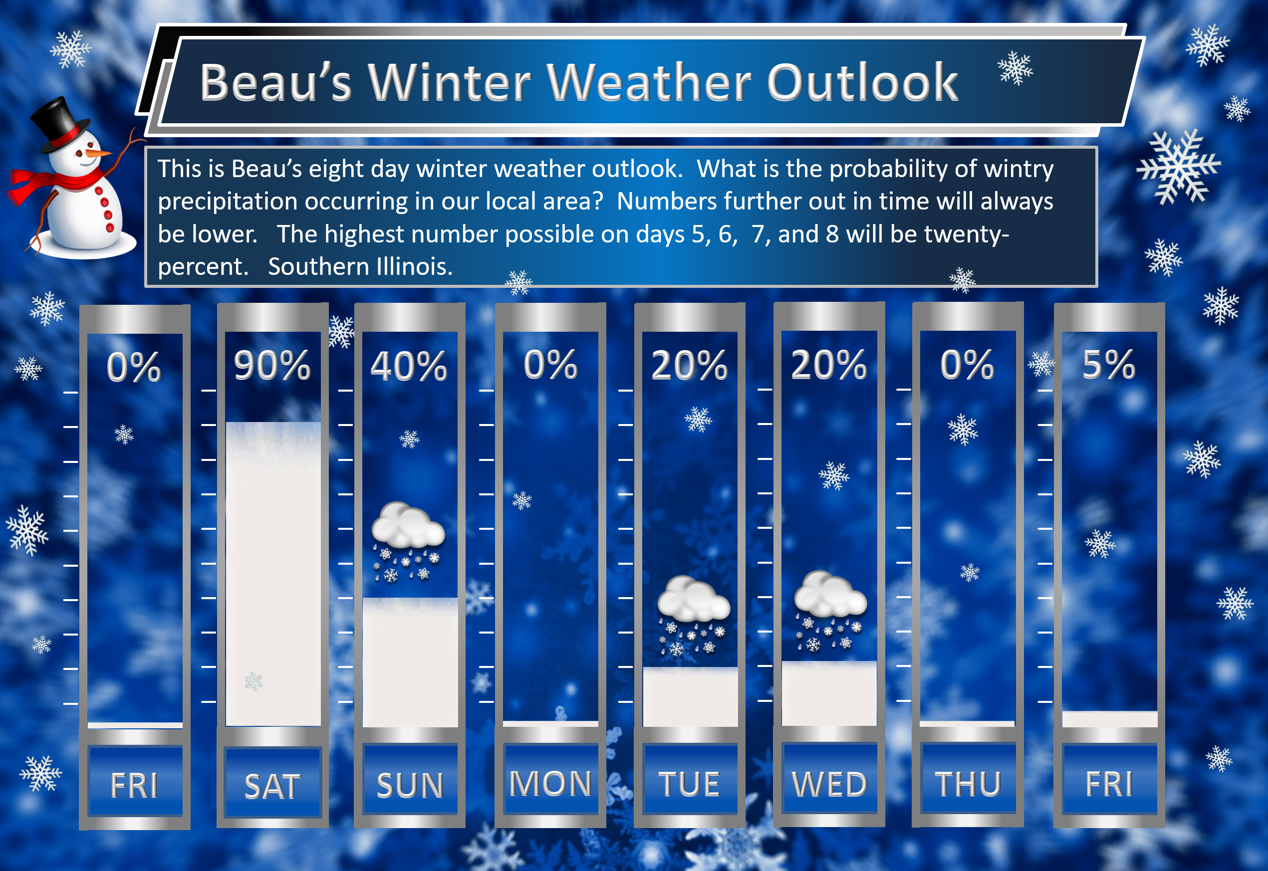
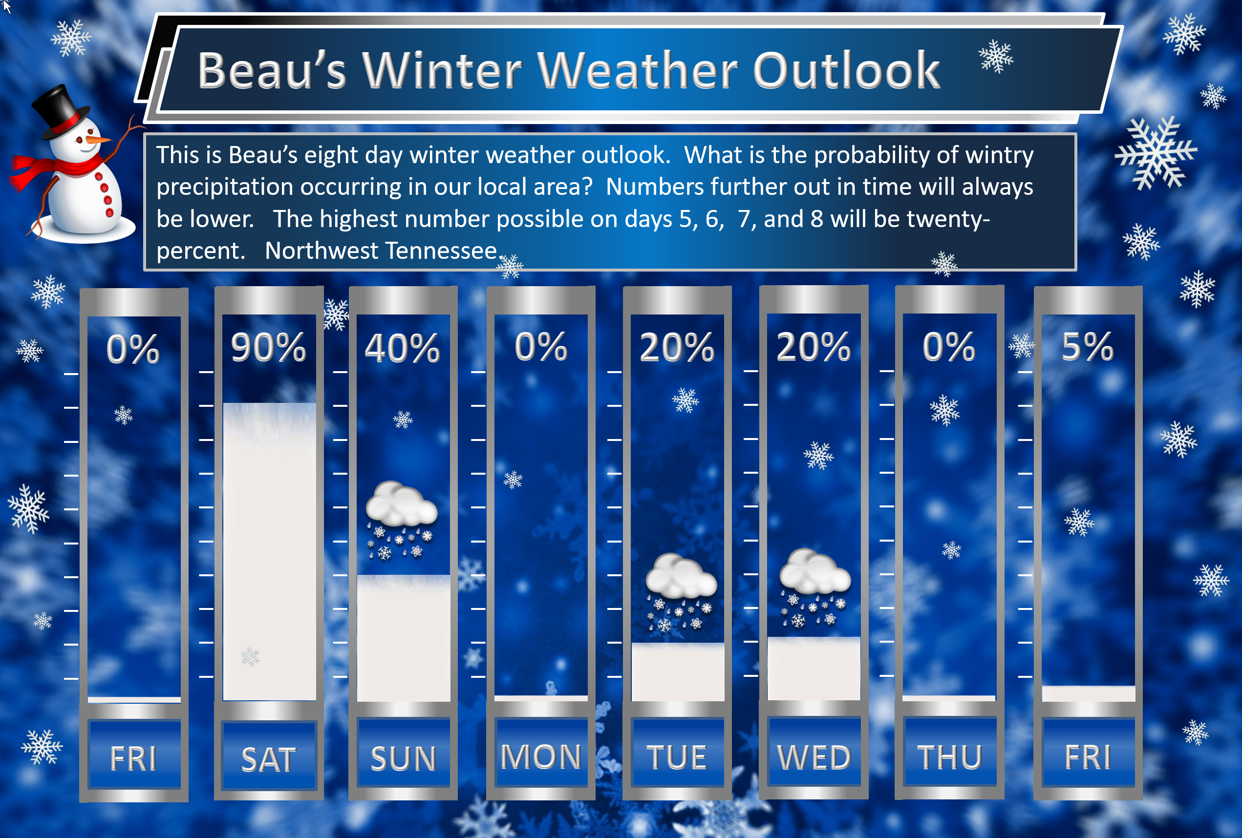
Beau’s exclusive eight-day winter weather outlook!
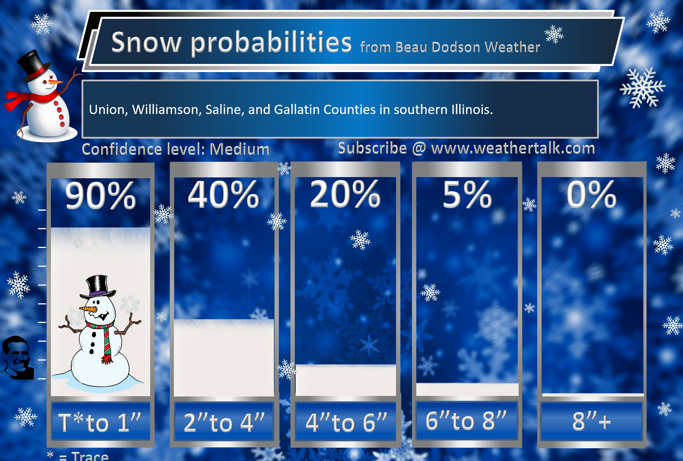
Southern Illinois.
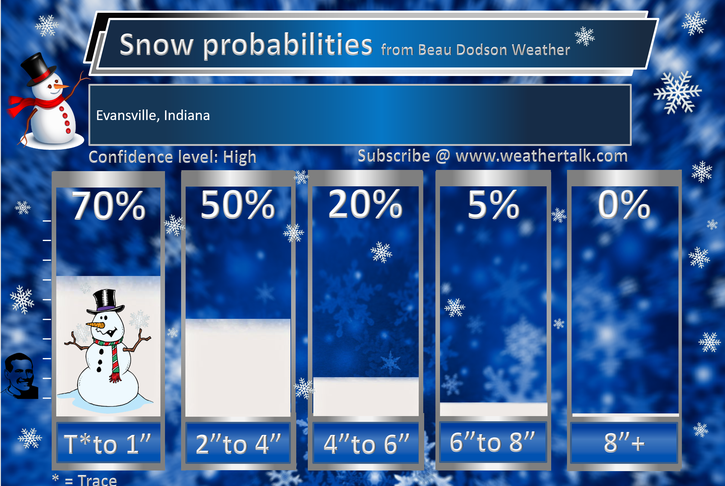
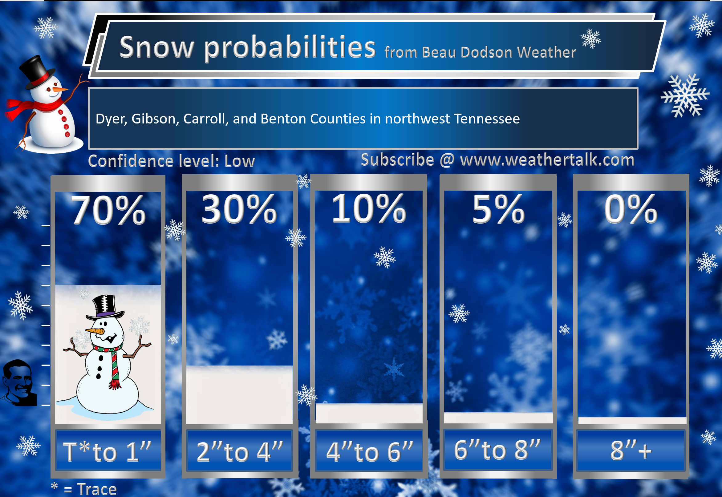
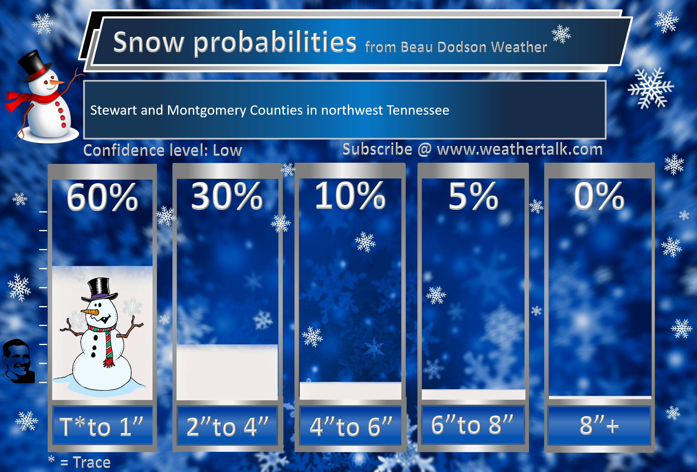
I have increased snow/sleet chances Saturday afternoon into Sunday morning.
The highest number possible on days 5, 6, 7, and 8 will be twenty-percent. That is because it is in the long range portion of the forecast.
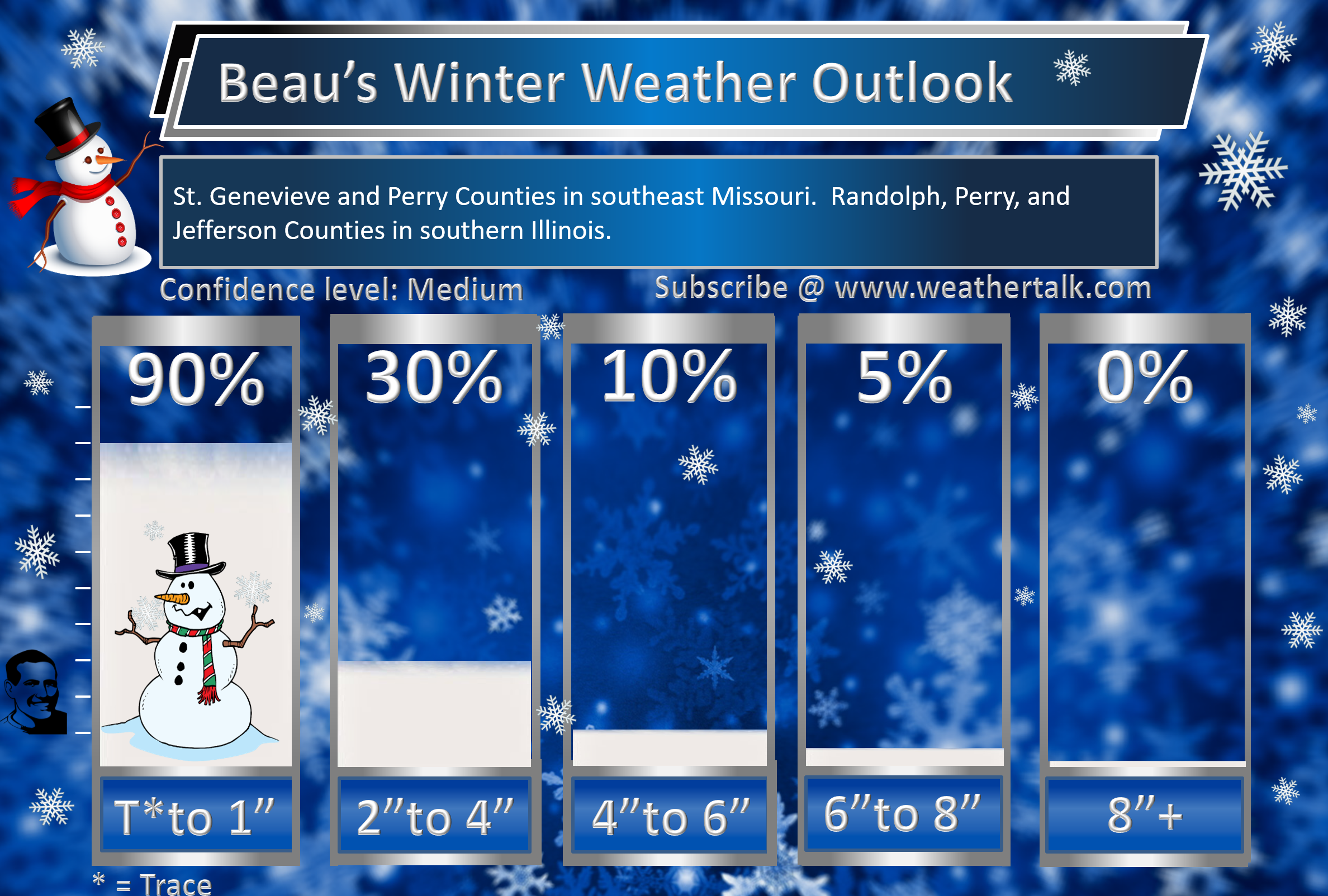
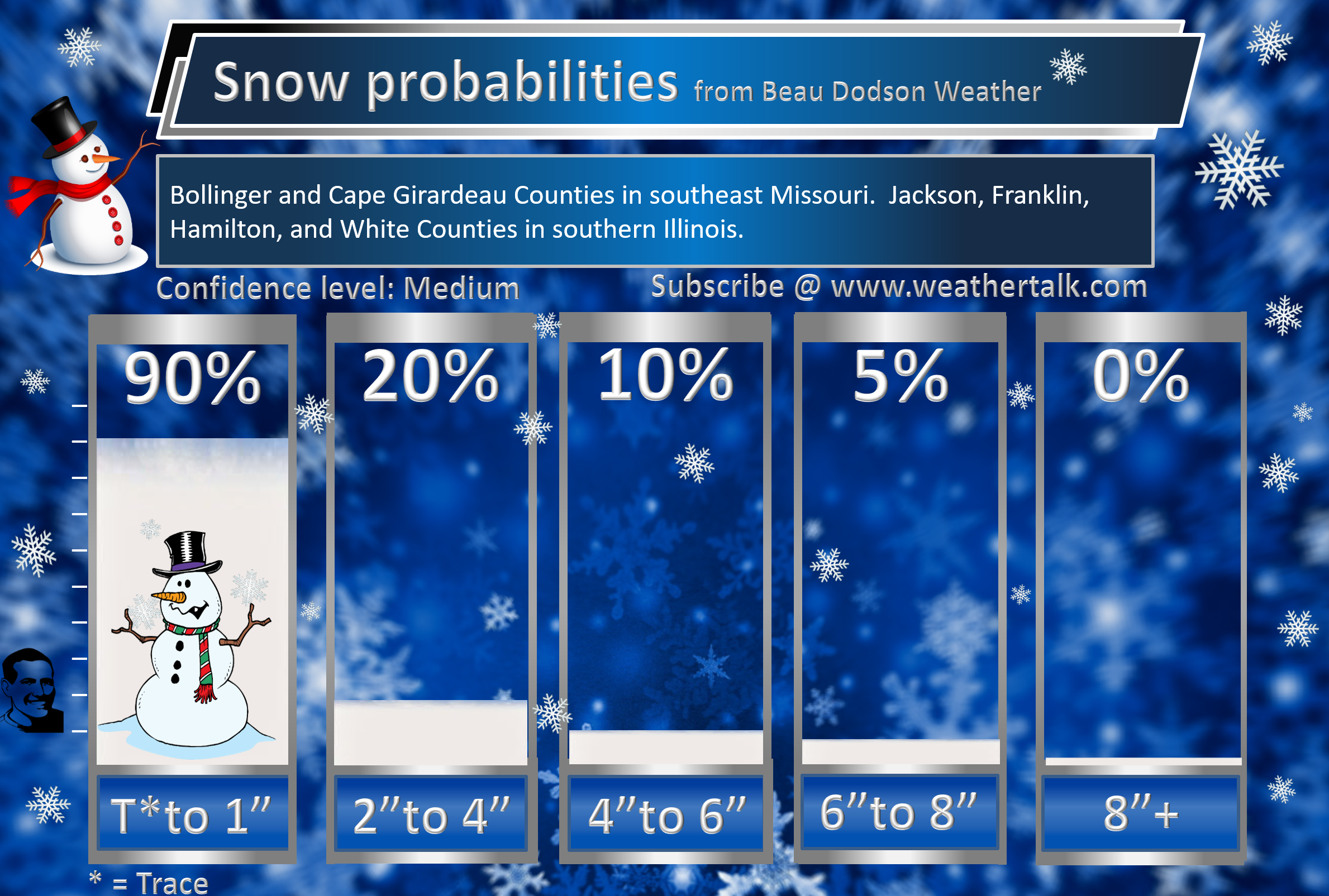
Southeast Missouri (excluding the Missouri Bootheel)
The highest number possible on days 5, 6, 7, and 8 will be twenty-percent. That is because it is in the long range portion of the forecast.

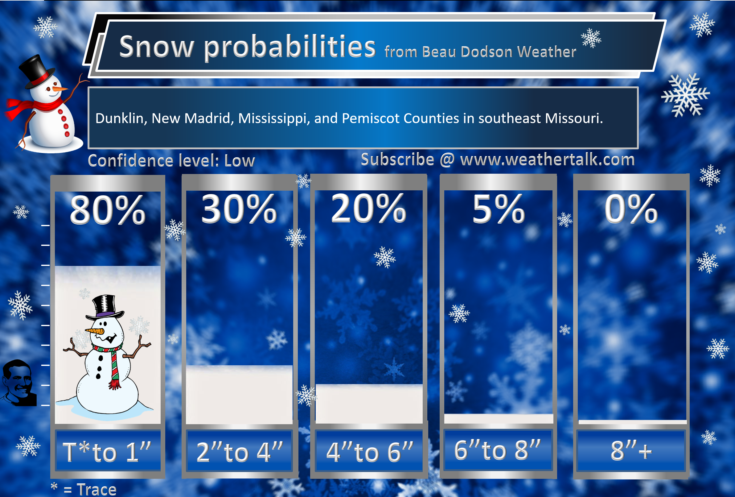
The Missouri Bootheel (New Madrid, Dunklin, and Pemiscot counties.
The highest number possible on days 5, 6, 7, and 8 will be twenty-percent. That is because it is in the long range portion of the forecast.

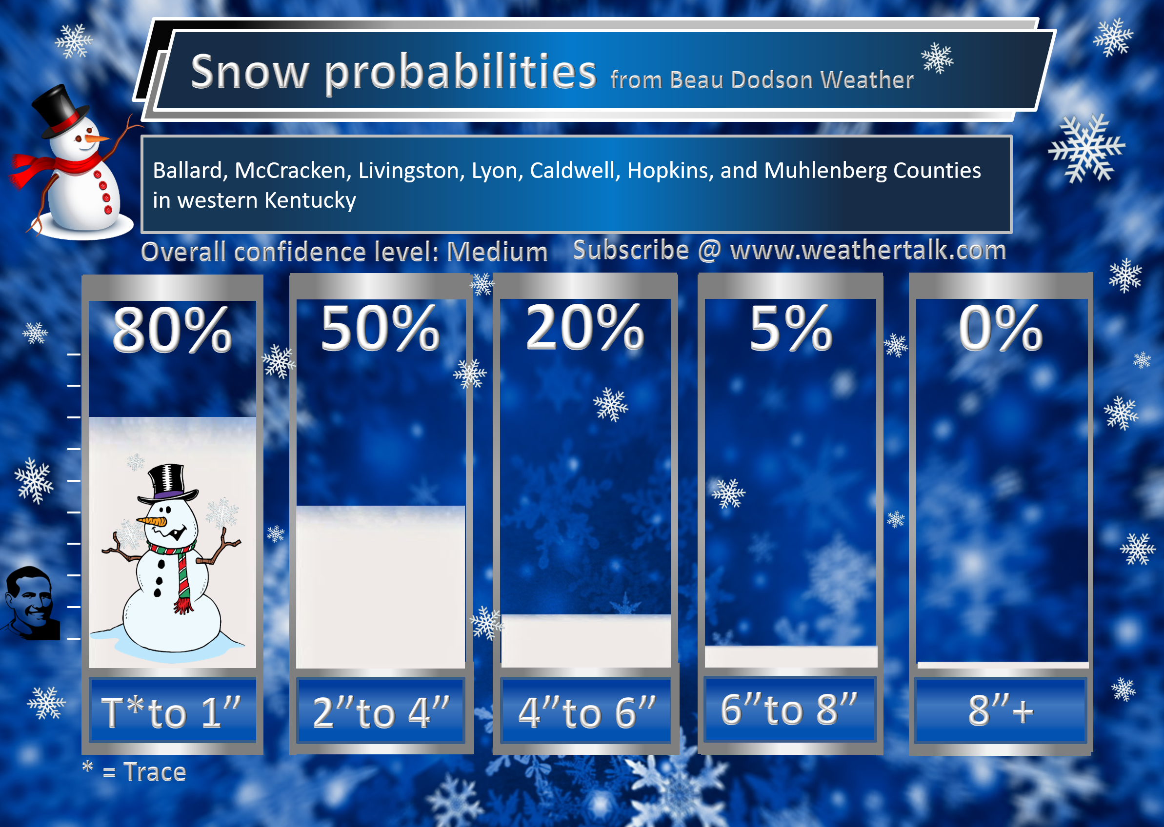
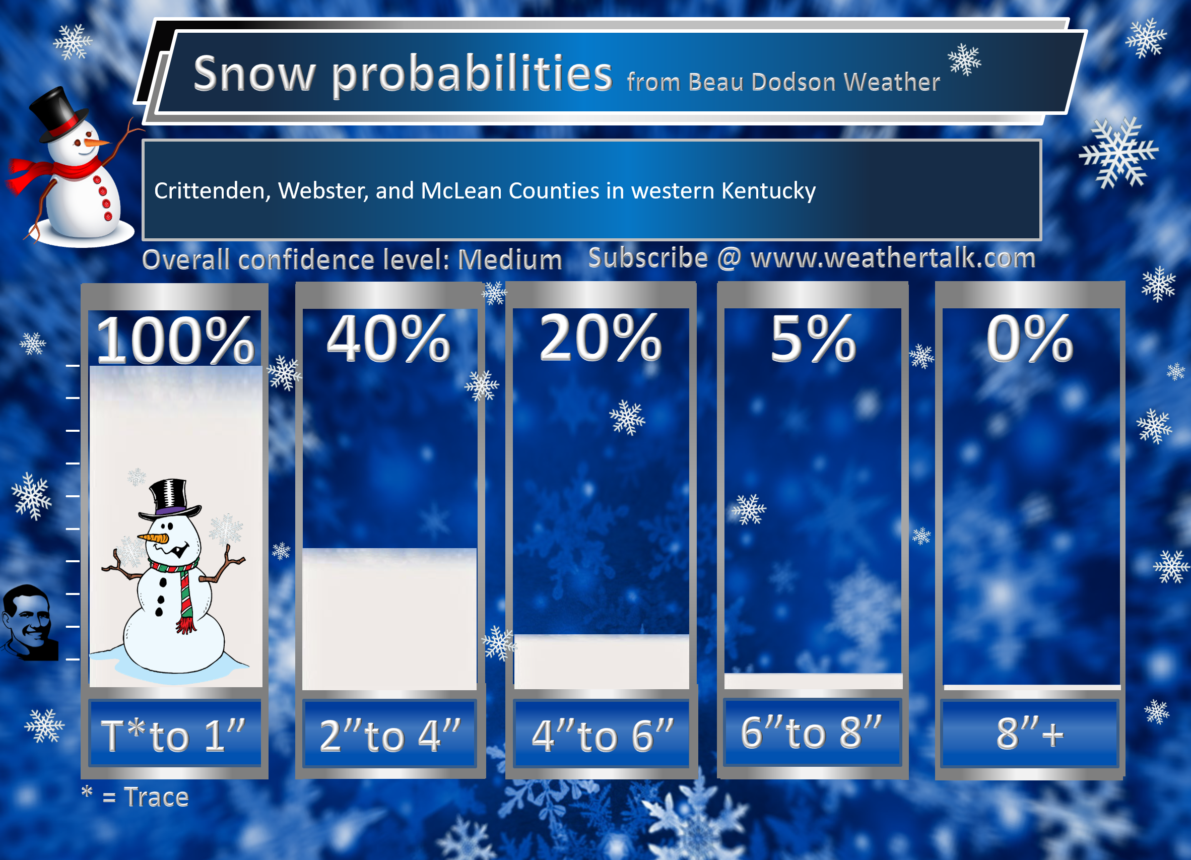
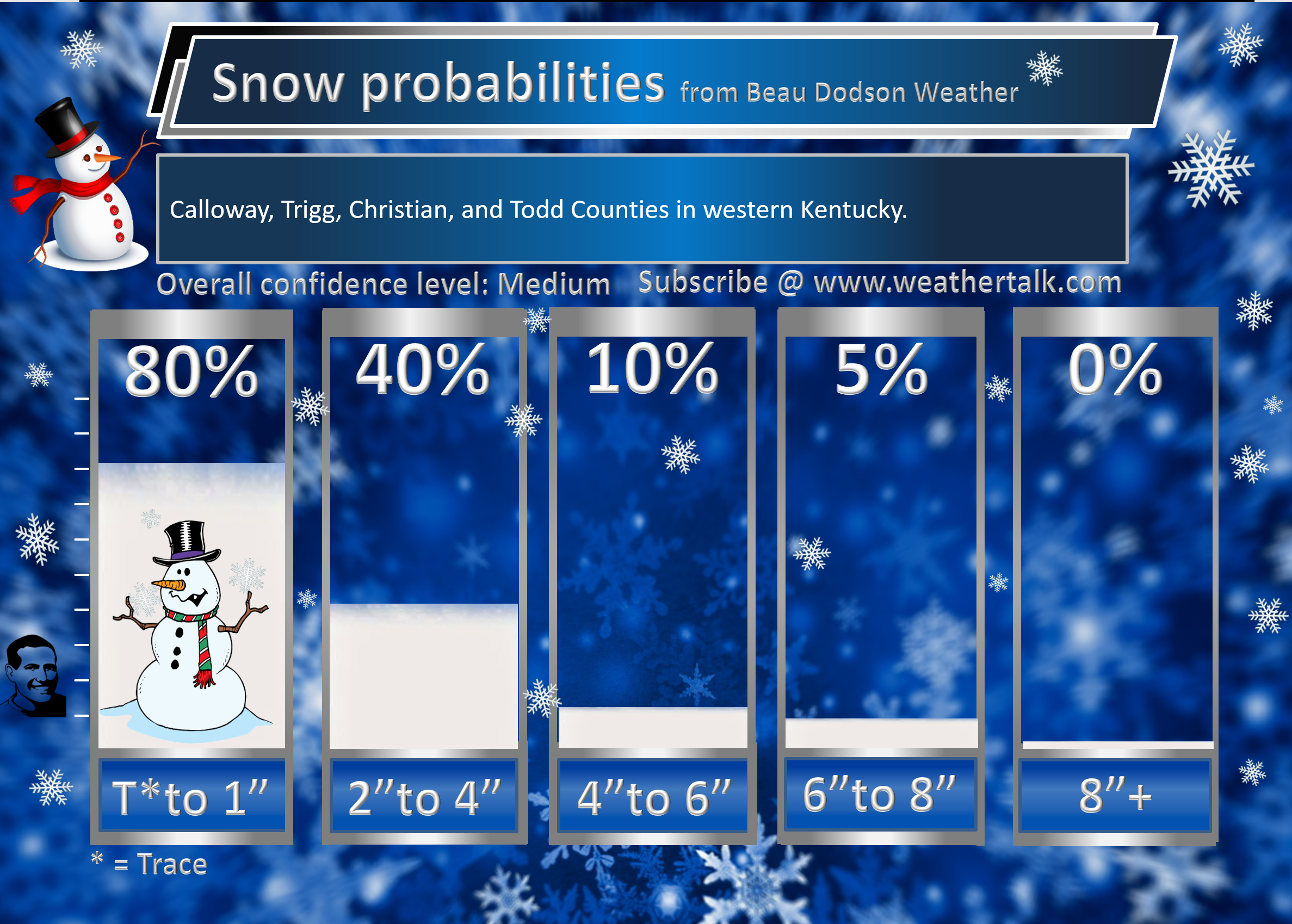
Western Kentucky
The highest number possible on days 5, 6, 7, and 8 will be twenty-percent. That is because it is in the long range portion of the forecast.

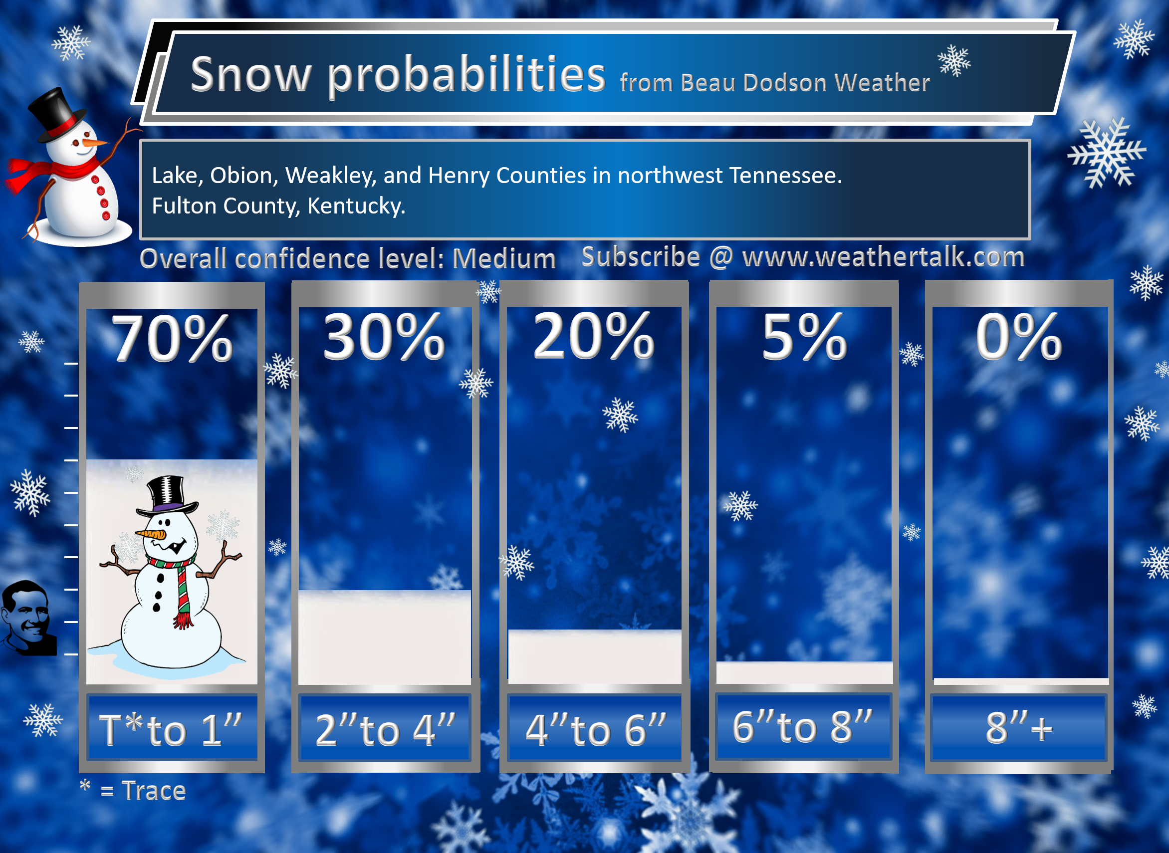
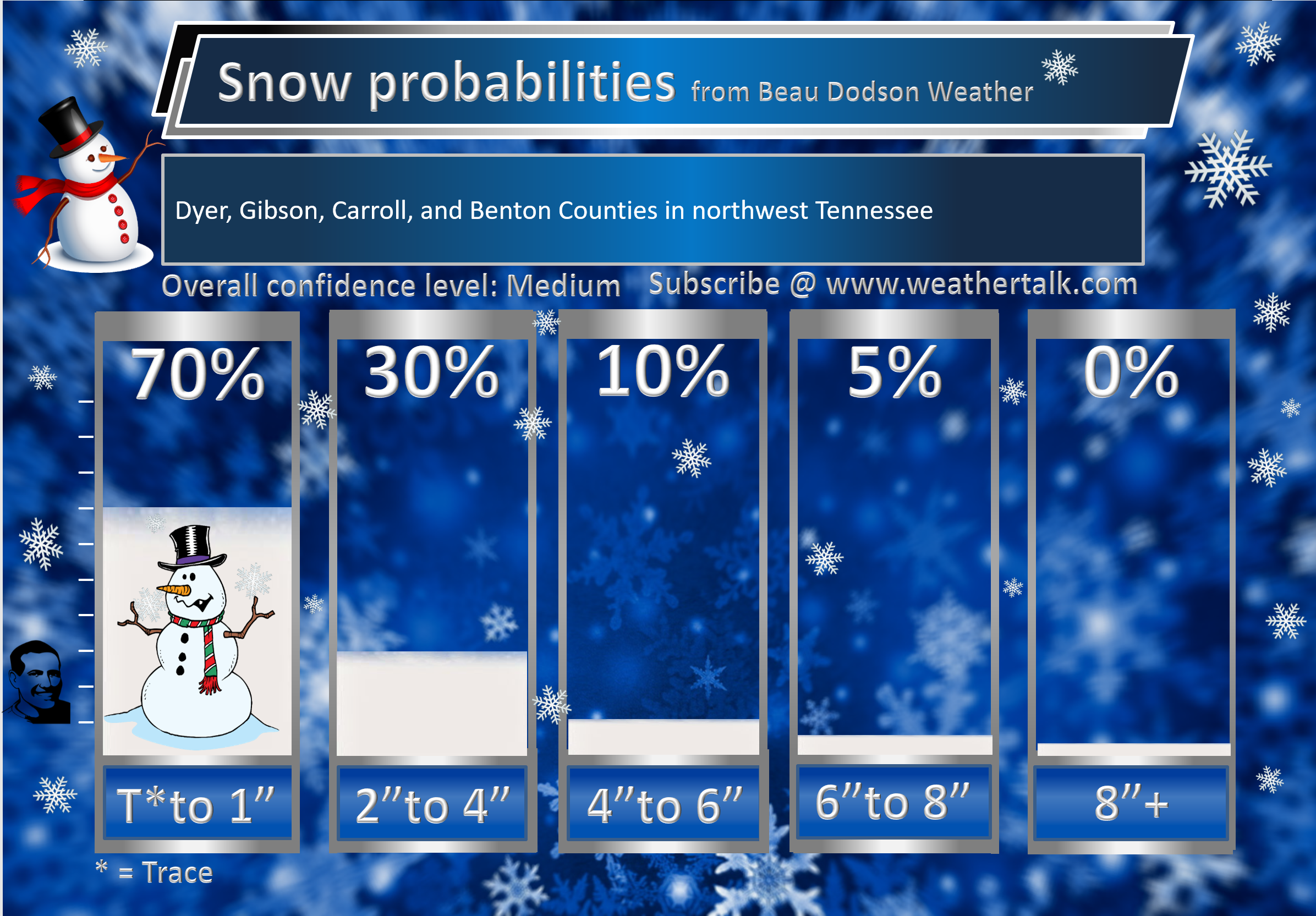
Northwest Tennessee
The highest number possible on days 5, 6, 7, and 8 will be twenty-percent. That is because it is in the long range portion of the forecast.
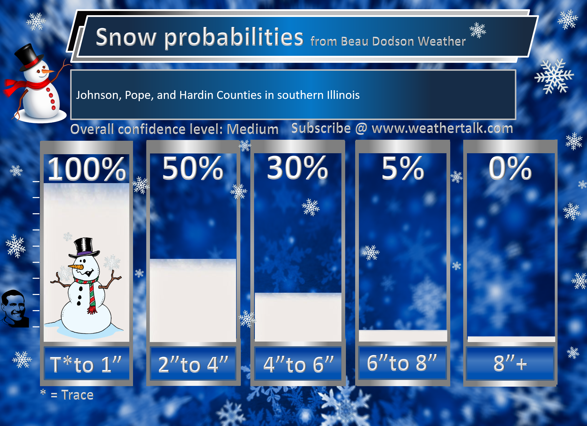
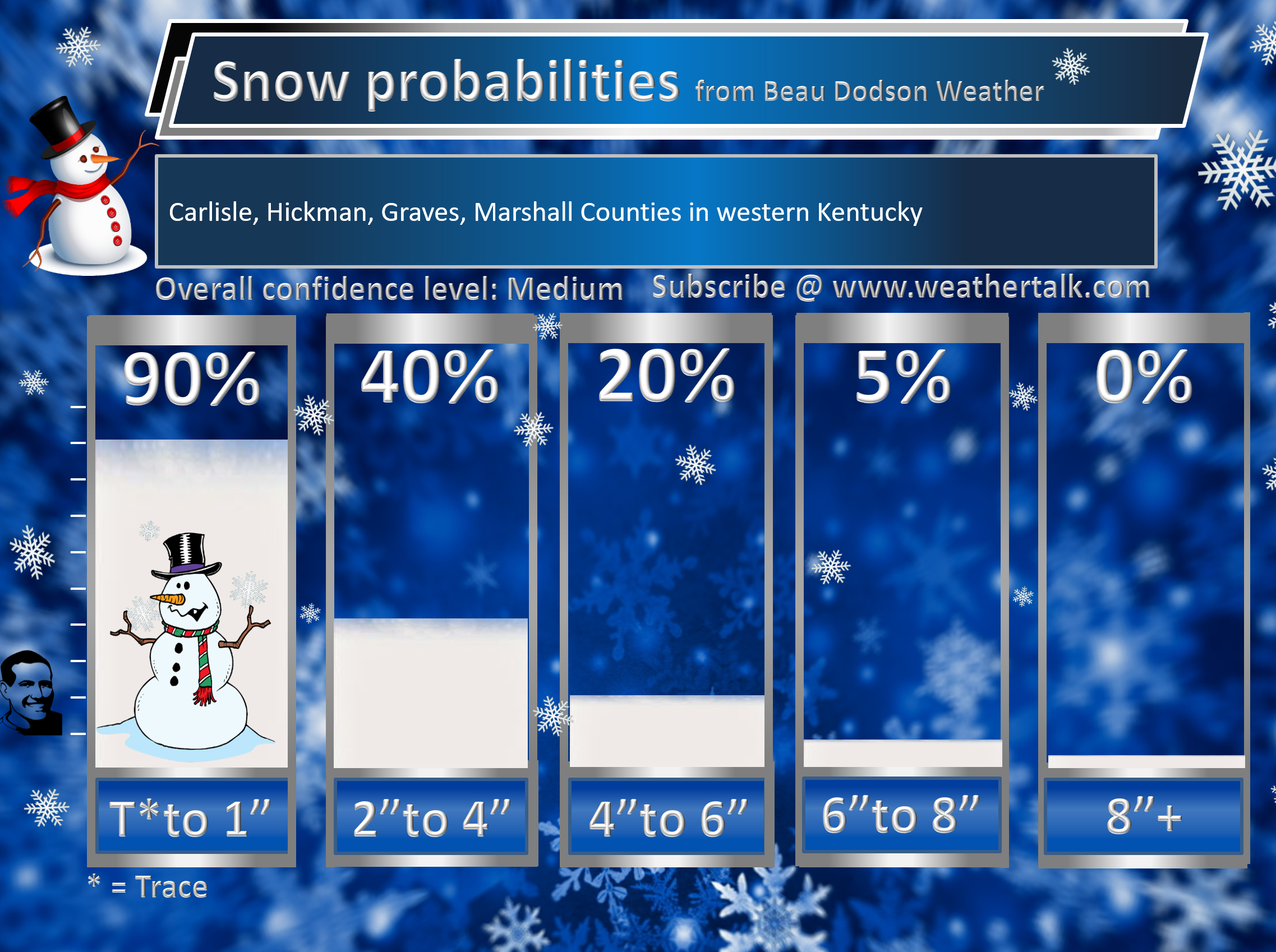
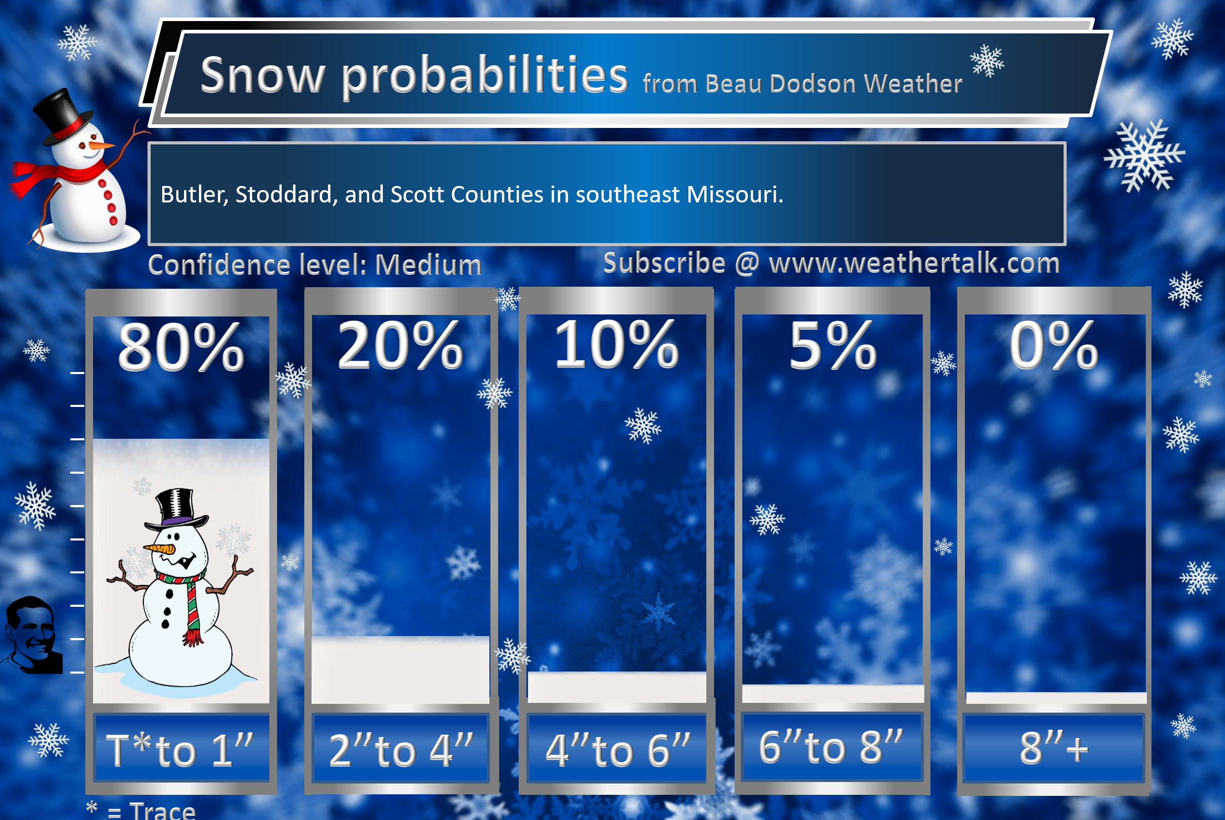
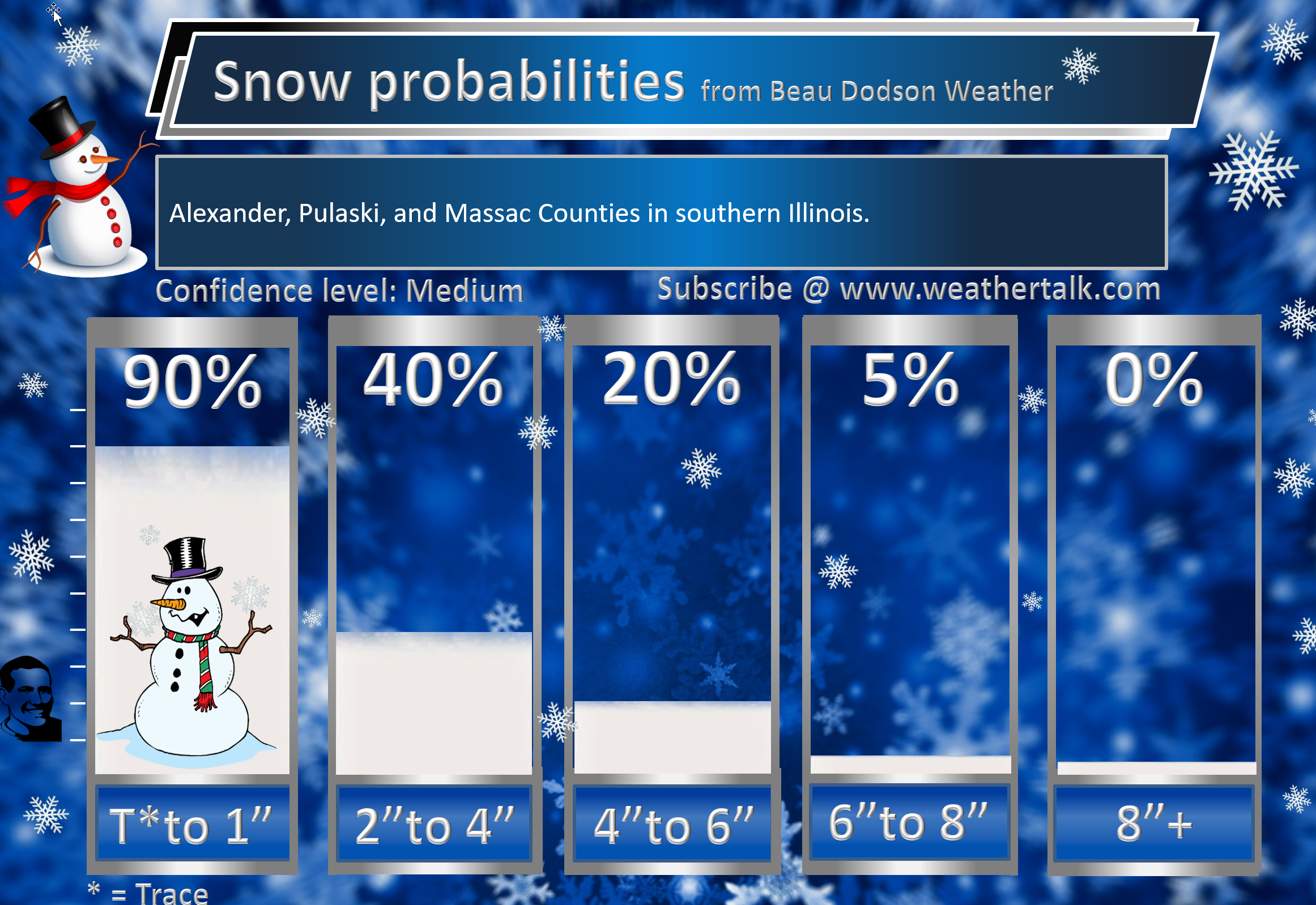
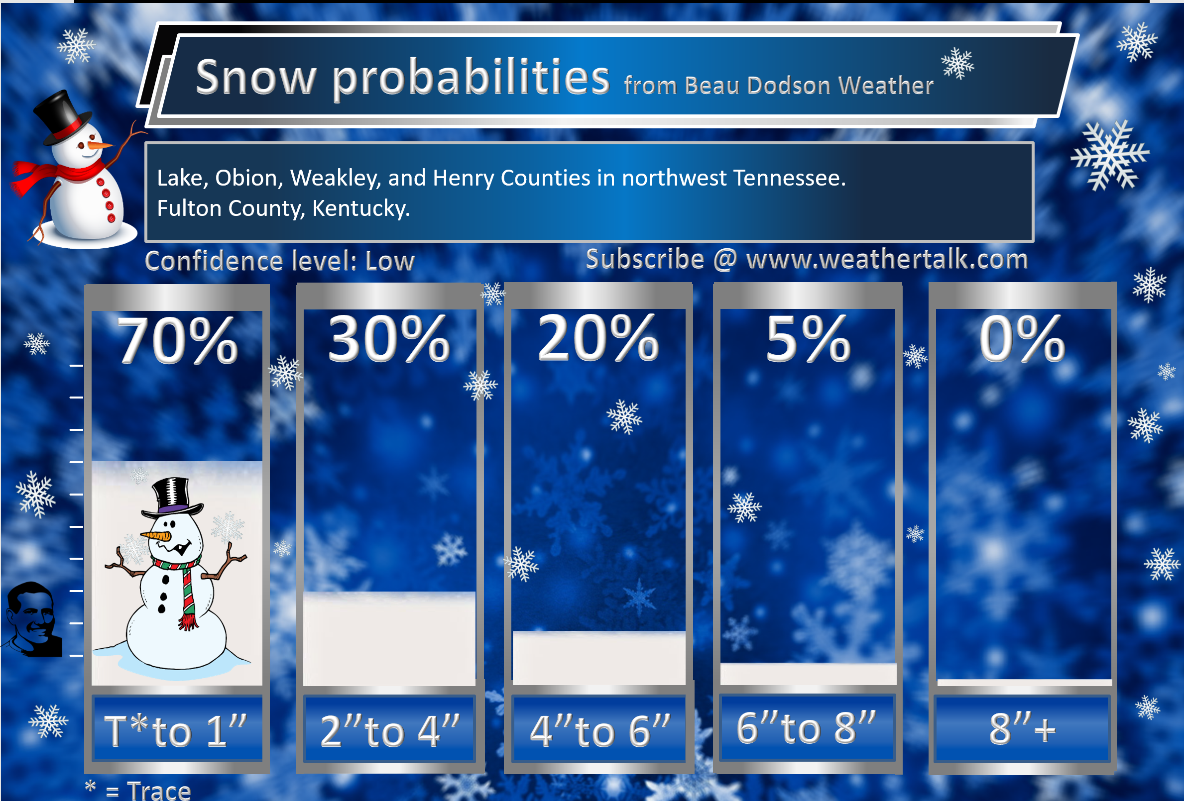
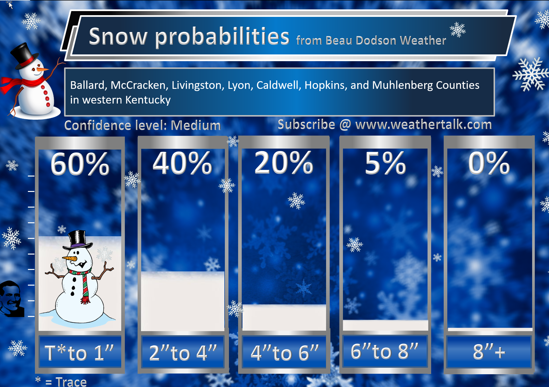
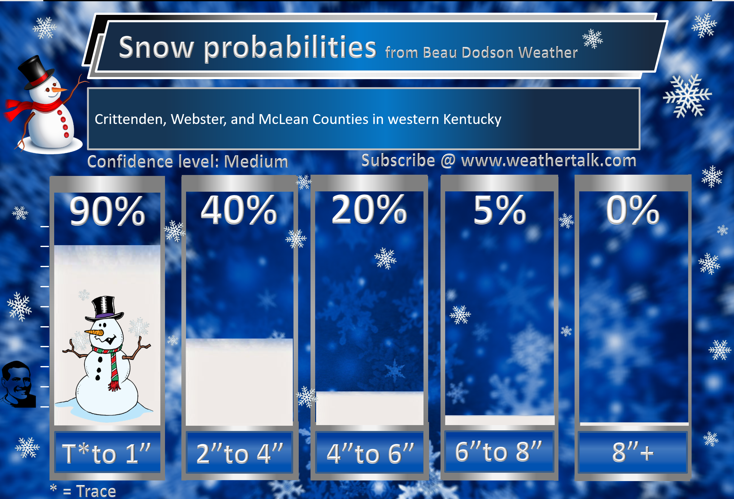
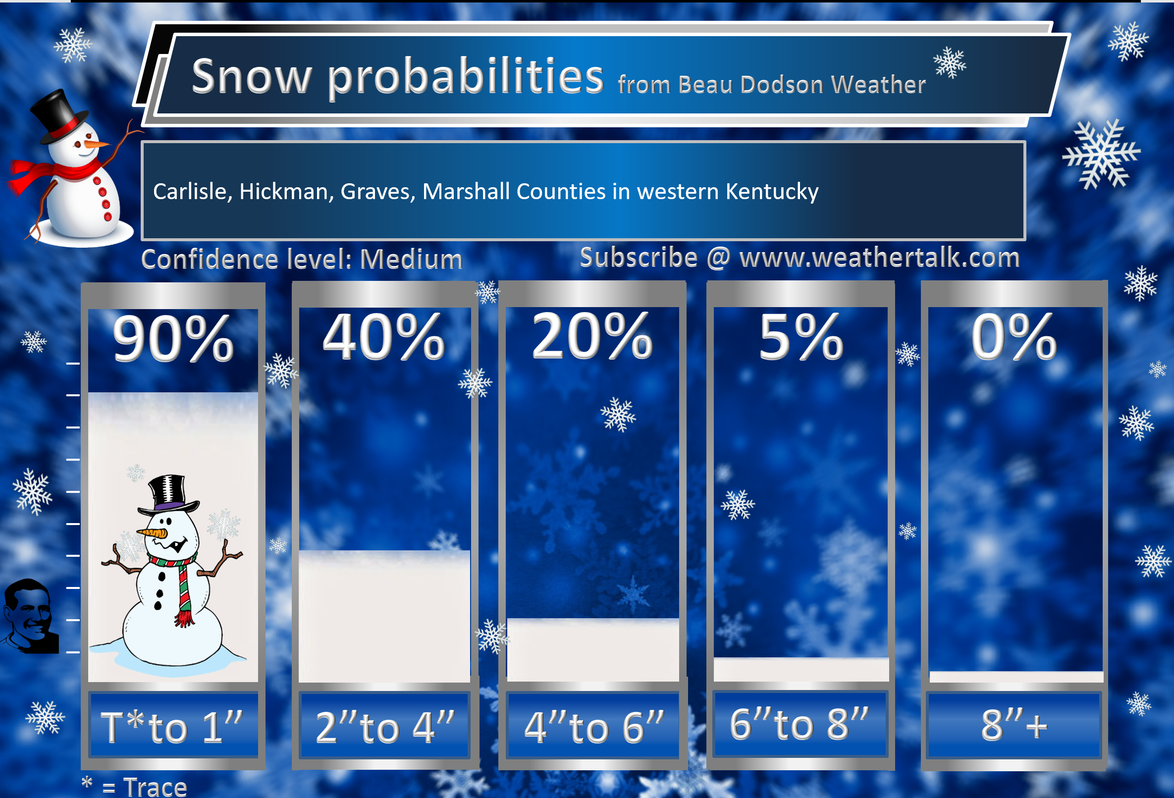
Here is the county by county break-down.
Confidence is low when it comes to exact snow (and some sleet likely) totals.
Some wintry mix/snow is likely to occur. Whether accumulating snow occurs is questionable. There is the potential of several inches of snow. Model guidance does indicate the potential of a heavier band somewhere in our region.
Keep in mind, model guidance shows anywhere from 0″ to 10″ of snow. In other words, model guidance isn’t coming into agreement on this potential snow event.
Focus more on the impact. The impact will be some black ice/icy surfaces.


Wind chill temperatures Saturday afternoon into Monday morning will be cold.
Wind chills will be even colder if we have a snowpack. Keep that in mind.
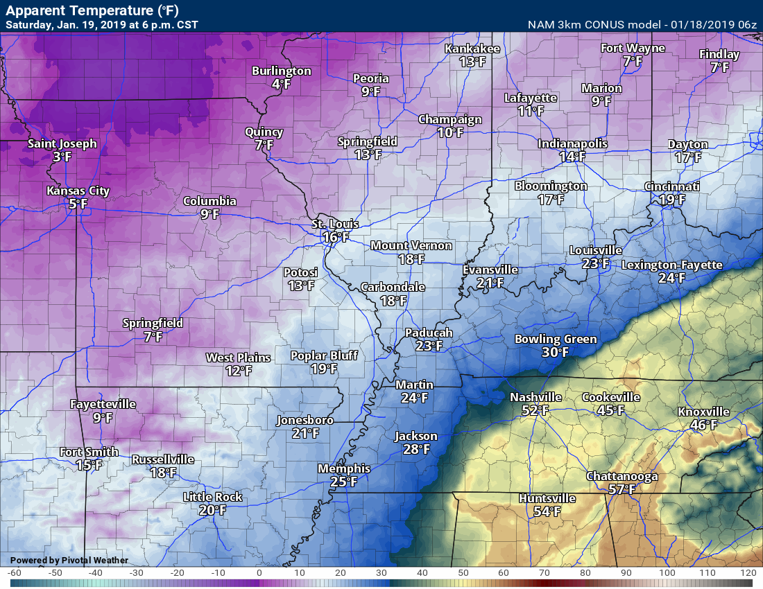
Saturday 6 PM
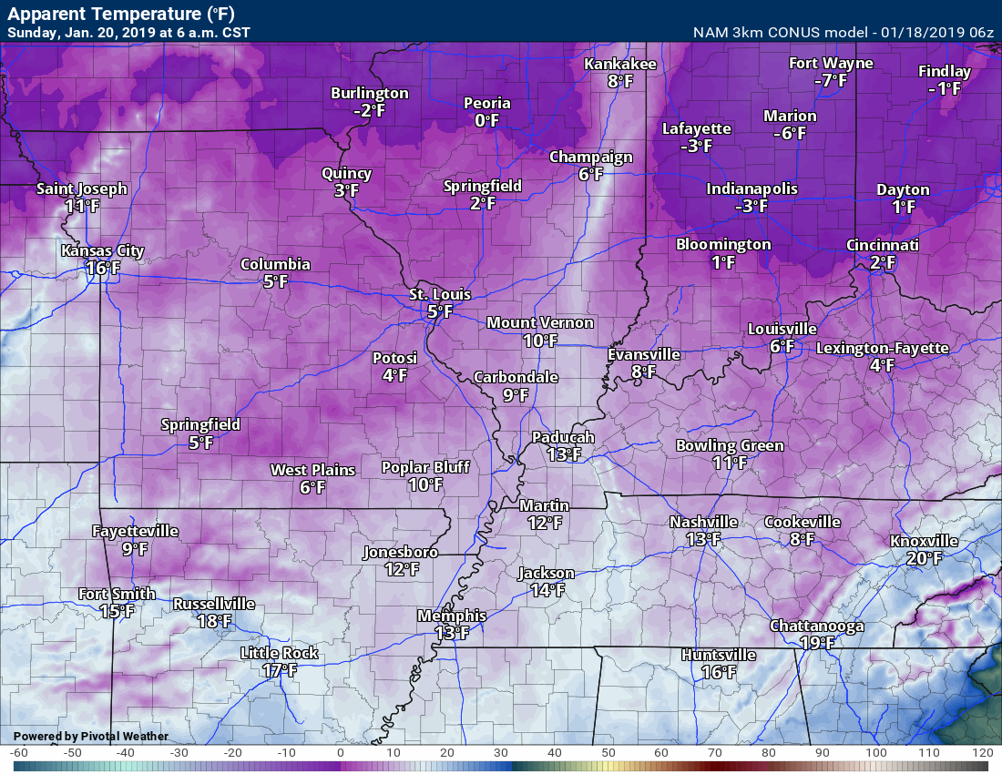
Sunday 6 AM
NOTICE:
I encourage subscribers to use the app vs regular text messaging. They will be the same messages. We have found text messaging to be delayed during severe weather. The app typically will receive the messages instantly. I recommend people have three to four methods of receiving their severe weather information.
Remember, my app and text alerts are hand typed and not computer generated. You are being given personal attention during significant weather events.

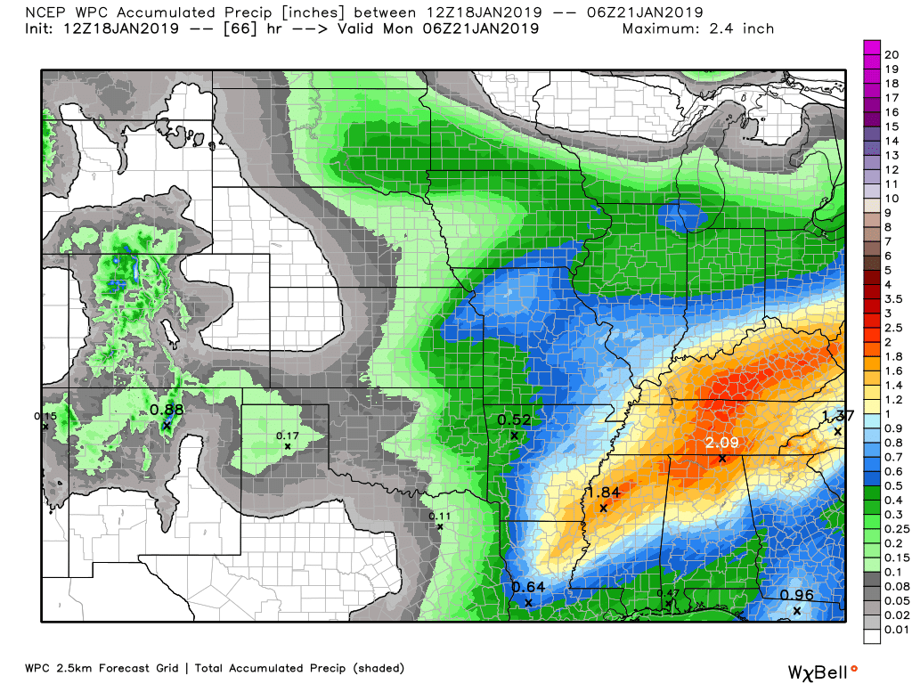
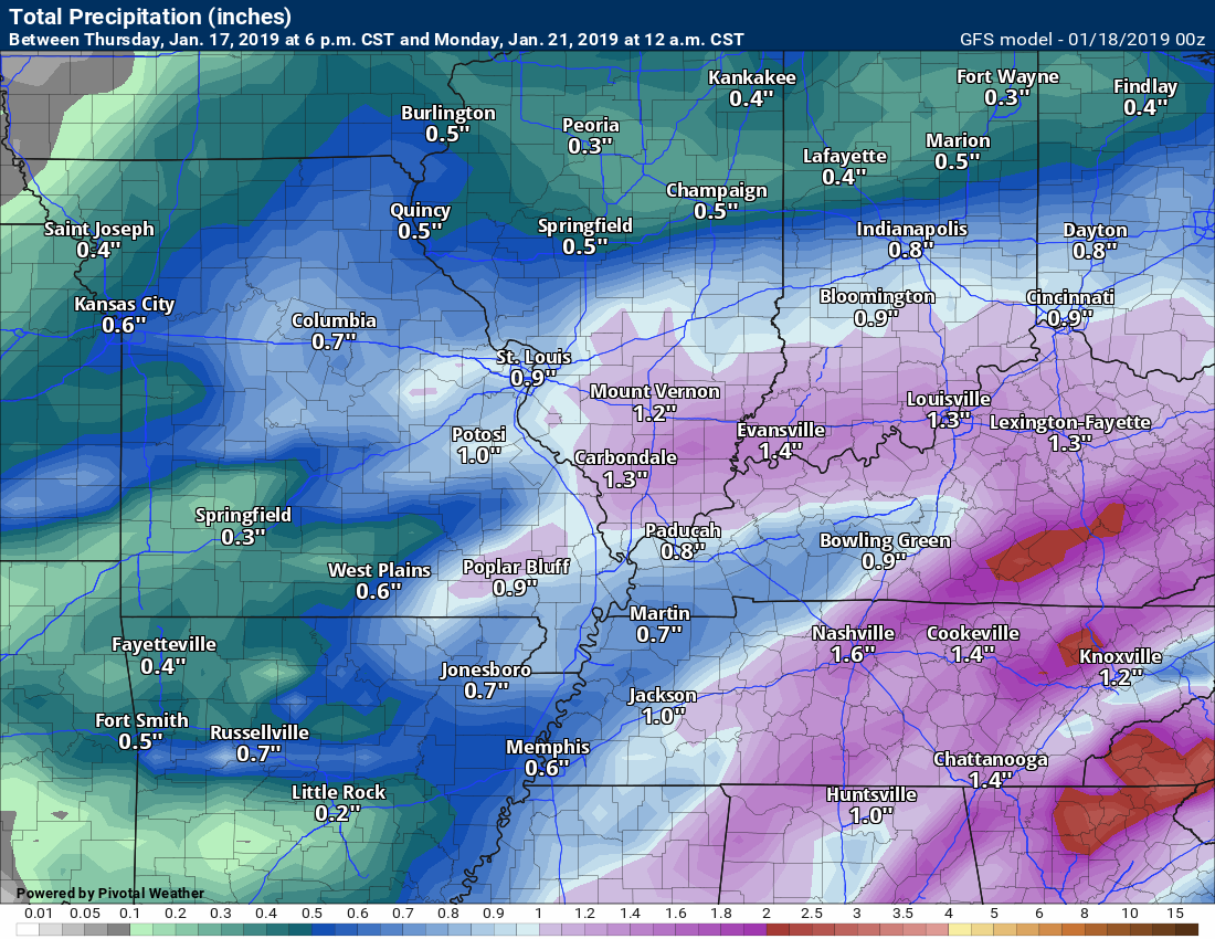
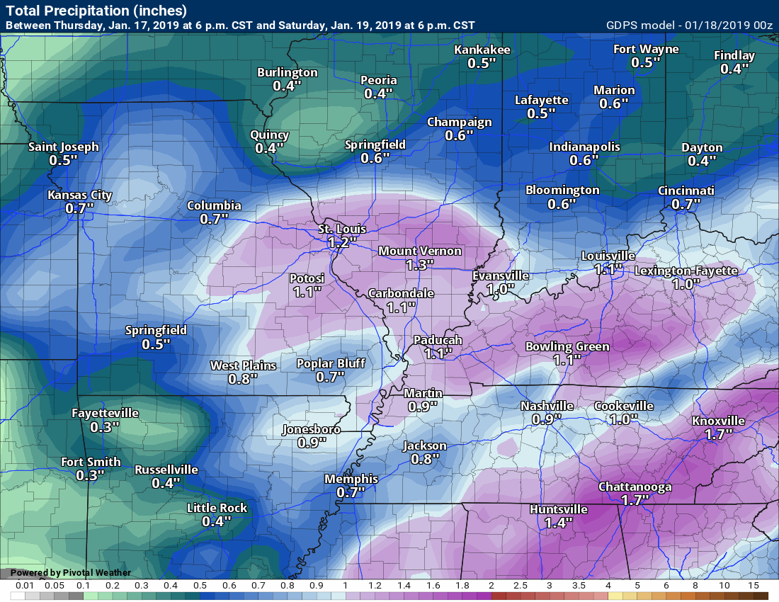
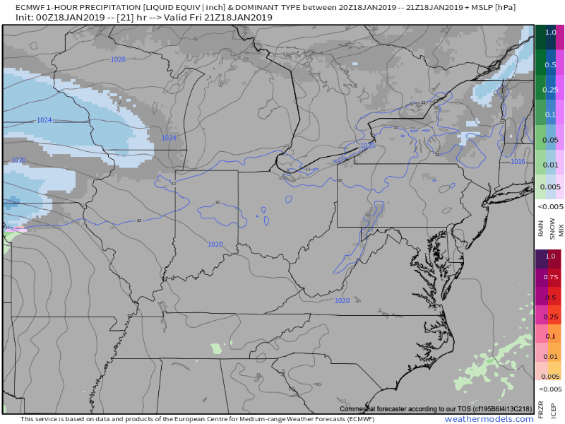
Here is the latest graphic from the WPC/NOAA.
This map shows you liquid and does not assume precipitation type. In other words, melted precipitation totals.
This next graphic is mainly tonight into Saturday night event. Locally moderate to heavy rain is possible.
You can expect a widespread 0.80″ to 1.60″.
And here are the seven-day rain/precip totals. Additional rain is likely next week.
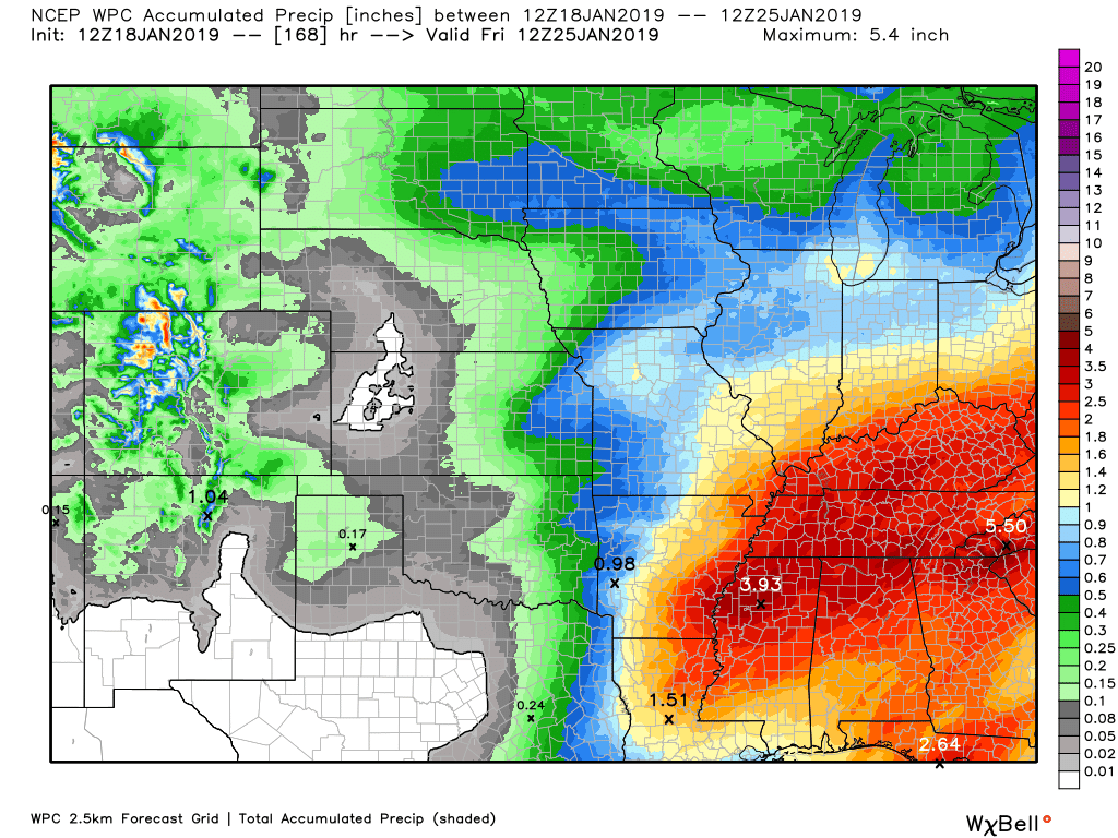
Let’s look at some model guidance rain totals.
The overall theme is to place the heaviest rain totals across parts of Arkansas/the Missouri Bootheel and then into Kentucky and Tennessee.
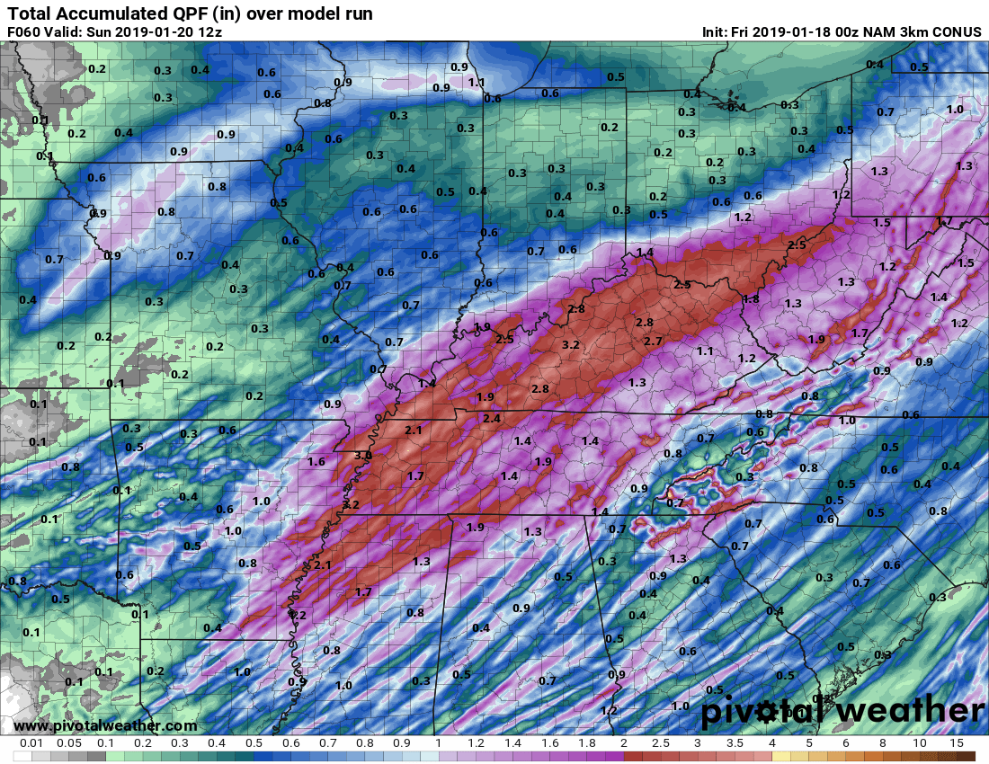
NAM 3K Model
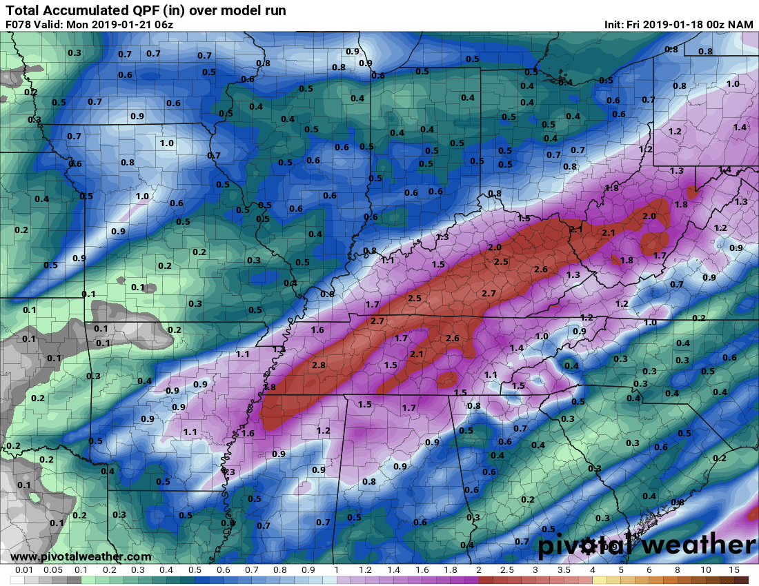
Regular NAM
GFS FV3
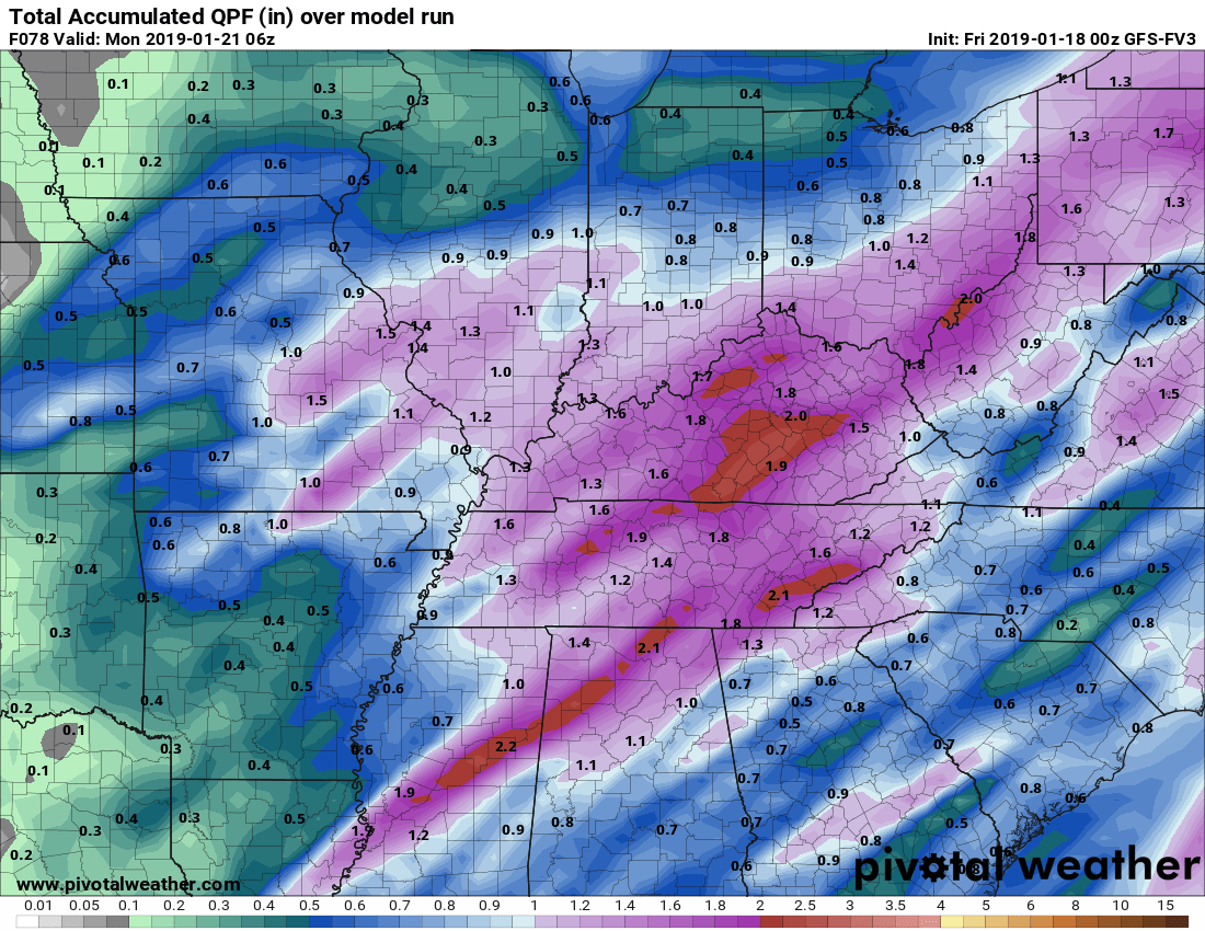
GFS model
Canadian model guidance
Subscribers, do you need a forecast for an outdoor event?

Did you know that you can find me on Twitter?

Click here for your interactive local city-view radars & regional radars.
During winter weather be sure and click the winterize button above each city-view radar. This will show you the precipitation type.

The National Weather Service defines a severe thunderstorm as one that produces quarter size hail or larger, 58 mph winds or greater, and/or a tornado.
Today through next Tuesday: Severe weather is not anticipated. I am monitoring the risk of lightning by Friday night into Saturday. That would most likely be across parts of Kentucky and Tennessee. At this time, severe weather appears unlikely.
Interactive live weather radar page. Choose the city nearest your location. If one of the cities does not work then try a nearby one. Click here.
National map of weather watches and warnings. Click here.
Storm Prediction Center. Click here.
Weather Prediction Center. Click here.

Live lightning data: Click here.

Interactive GOES R satellite. Track clouds. Click here.

Here are the latest local river stage forecast numbers Click Here.
Here are the latest lake stage forecast numbers for Kentucky Lake and Lake Barkley Click Here.

- Widespread precipitation event Friday night into the weekend.
- A wintry mix possible Saturday afternoon into Saturday night.
- A flash freeze is likely Saturday afternoon into Saturday night. Rapidly falling temperatures could cause the remaining moisture to freeze on roadways.
- Wind chill temperatures Saturday afternoon into Monday will drop into the single digits and teens.
- Another precipitation event Tuesday/Wednesday
Current conditions as of 8 AM
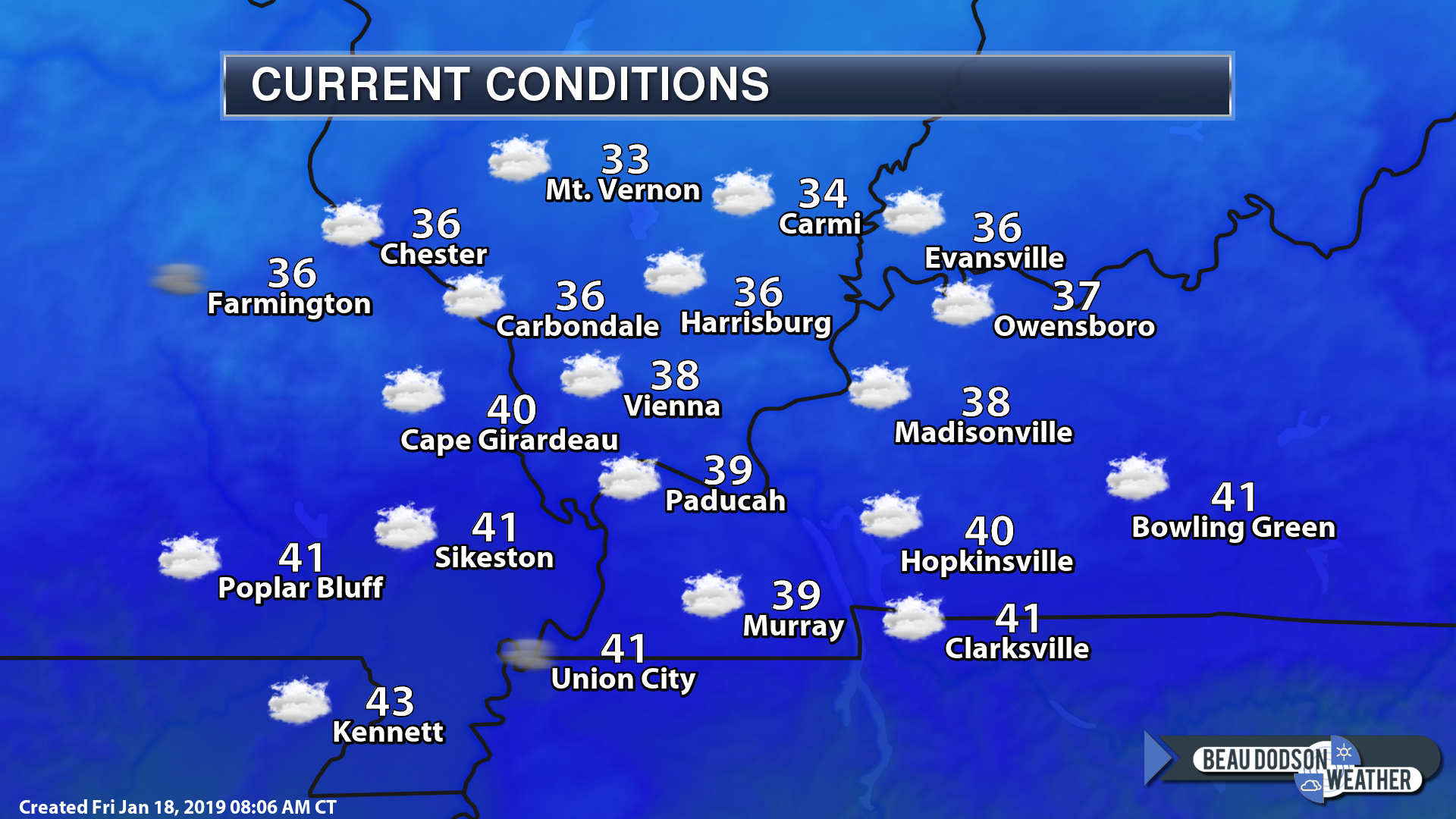
Changes over the last 24 hours.
No major changes in the overall forecast.
Widespread rain will overspread the region tonight. There could even be some flashes of lightning.
Rain will continue into Saturday morning. There may then be a bit of a lull before more precipitation develops behind the area of low pressure.
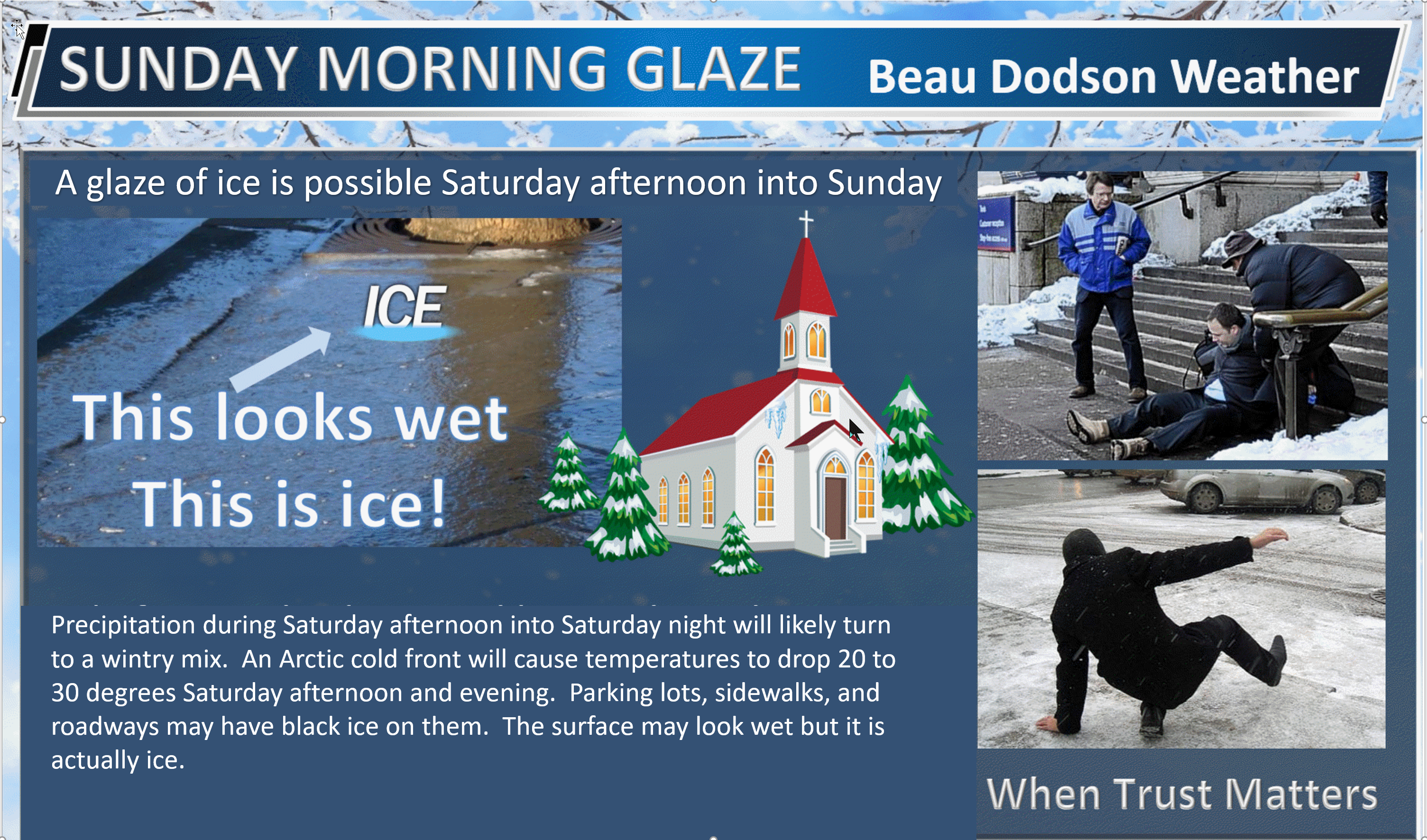
The main concern continues to be the threat of black ice and a wintry mix Saturday afternoon into Sunday morning.
What is black ice?
Black ice is simply moisture that freezes on surfaces.
Pretend the following
Take a garden hose outside when it is 33 degrees and hose down your patio.
In a short amount of time, the temperature drops 10 degrees and is now 23 degrees.
The moisture did not have enough time to dry off the surface.
The water left turns to a thin glaze of ice.
That is black ice.
Black ice is simply moisture that remains on surfaces and then freezes.
Normally, the wind will dry the roads off as temperatures slowly fall behind a cold front.
Sharp fronts are not like that. Temperatures can fall 10 to 20 degrees in an hour or two.
Rain will occur ahead of this cold front Saturday. It may not have time to dry before it freezes on surfaces. That means parking lots, roads, and so on.
Black ice is not caused by precipitation falling from the sky when it is cold. It is caused by moisture that is left over.
To complicate this event is that precip may actually continue as temps rapidly fall. That increases the risk of icy patches.
Freezing rain is rain that freezes on surfaces. Black ice is moisture that is left over after the precip ends and then it freezes.
Confidence in the forecast
Confidence in today and tonight’s forecast is high.
Confidence in Saturday mornings forecast is high.
Confidence in Saturday afternoon into Sunday’s forecast is low to medium.
Confidence in the Monday through Wednesday forecast is low to medium. Lower confidence when it comes to precipitation type as we move later into Tuesday night and Wednesday.
Action?
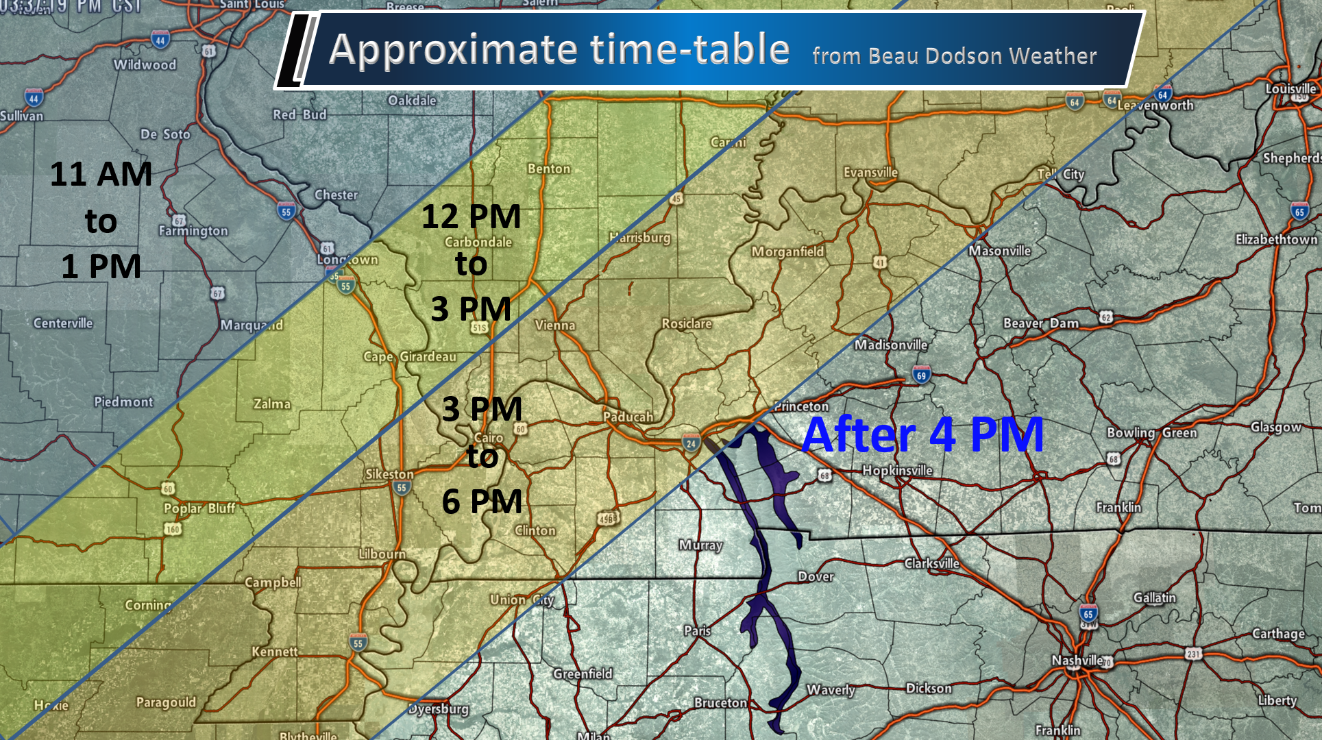
Plan on the potential of icy roads and black ice starting over my far northwest counties (Perry County, MO to Jefferson County, IL northward) as early as late Saturday morning or early afternoon. The concerns then spread south and east through the afternoon and overnight hours.
Sunday morning church services may have to deal with black ice on their parking lots.
If snow and sleet develop then, of course, the concerns increase for icy road conditions and icy parking lots.
Protect your exposed skin from wind chill values in the single digits Saturday night into Monday morning.
Winds will be gusting into the 20 to 35 mph range at the peak of the event. That would be Saturday afternoon into Sunday morning.
Bottom line:
Confidence is growing that we will see the rain changing to a wintry mix and snow by Saturday afternoon into Saturday night.
The freezing line will first approach our northwest counties and then move east/southeast. This will begin Saturday morning over my far northwest counties. The cold air will then push east/southeast.
Some accumulation of snow/sleet is possible. Placement of the accumulating snow remains a question. Don’t focus on snow totals. Focus on the impact. Some icy surfaces are possible.
A flash freeze is likely behind the cold front. That is when temperatures drop so fast that the moisture on roadways does not have time to dry. This would cause black ice.
Strong winds could blow the snow around (if snow does accumulate).
Quick summary
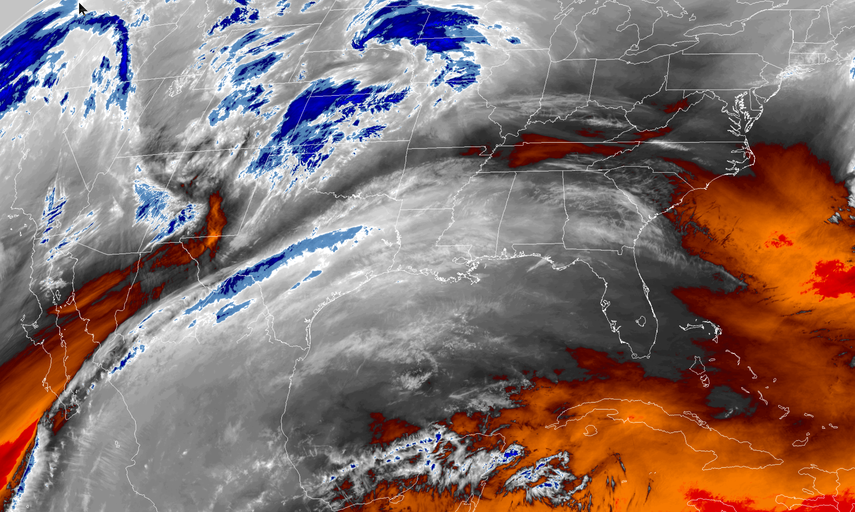
Today will be dry. Clouds continue to linger in the region. We have not had much success this week at finding sunshine.
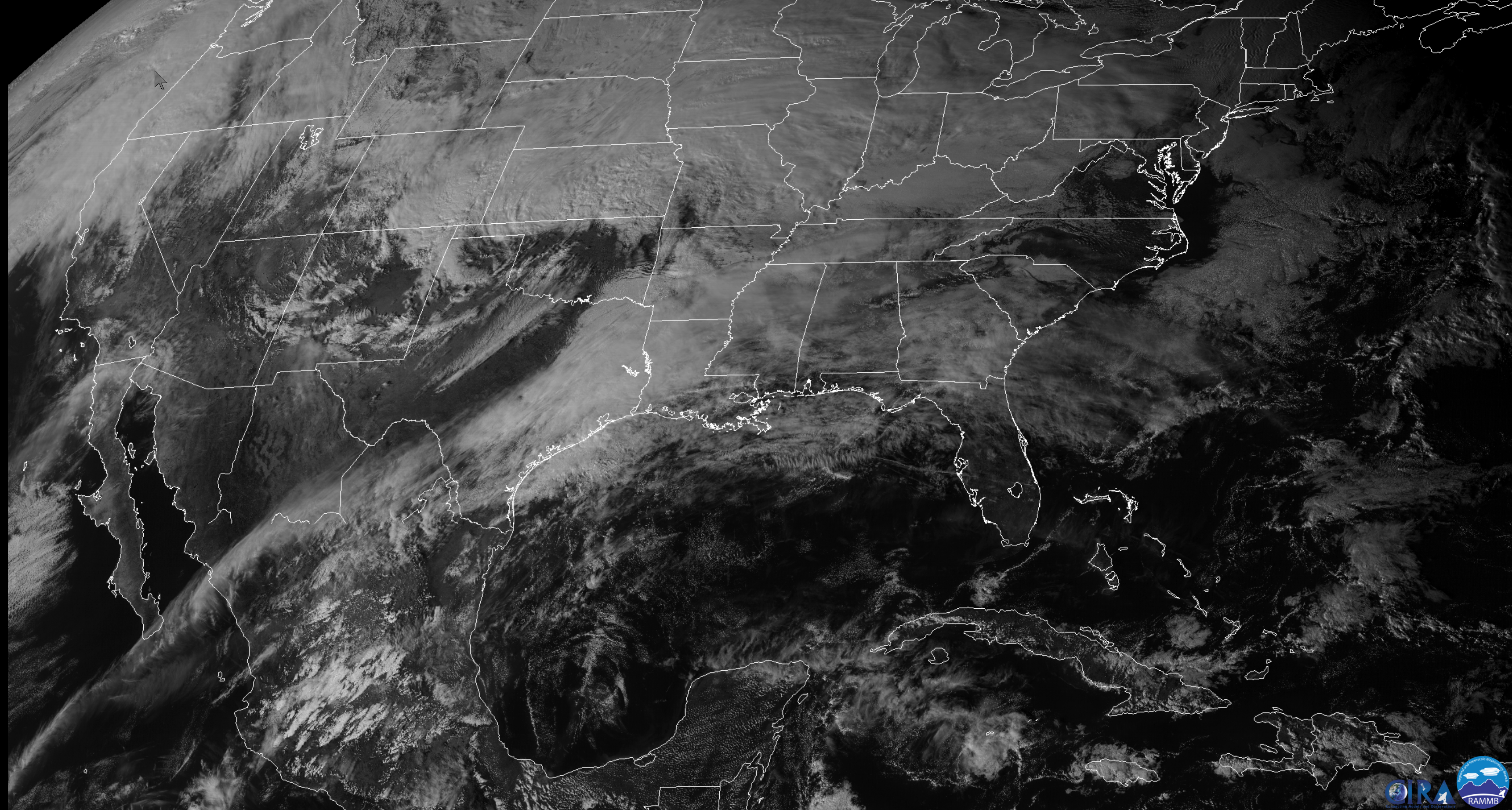
Clouds will linger today. Morning satellite did show clearing over southern Missouri into Tennessee.
Here was the morning satellite view (7 AM).
Interactive GOES R satellite. Track clouds. Click here.
Rain chances rapidly increase tonight into Saturday. A strong Arctic cold front slams into the region Saturday late morning into the evening hours. Rapidly falling temperatures behind the front. Temperatures will drop 15 to 30 degrees.
Rain will change to snow or a wintry mix behind the cold front. How much precipitation remains behind the front is still a question.
Forecast details.
Today’s high-temperature forecast
Tonight’s low-temperature forecast
Tomorrow’s high-temperature forecast
Tomorrow night’s low-temperature forecast
Friday night into Sunday morning.
Widespread rain tonight.
A winter storm will impact portions of the central and eastern United States Friday into the weekend.
Weather discussion:
Big weather changes are on the way. If you have been reading the forecast all week then this will not come as a surprise.
This has been a well-forecasted weather event.
This will be the coldest air of the season, thus far. It won’t be the last blast of cold air, either.
The colder air will arrive Saturday afternoon into Sunday. Temperatures will rebound as early as Monday night and Tuesday ahead of our next storm system.
Plan on a roller-coaster ride of temperatures over the coming weeks.
Check out this temperature animation.
Notice this is a quick shot of cold air. The guidance already bumps temperatures up again by Monday night and Tuesday. This will be in response to another storm system that will bring additional precipitation chances early next week.
Actual readings will vary. If we do end up with snow or ice then temperatures could be colder (if sky conditions clear Sunday night).
The time-stamp is located in the upper left part of the graphic.
Click to enlarge.
Strong and gusty winds will accompany the front, as well.
Here is the wind gust map forecast. The date/timestamp is located in the upper left portion of the animation.
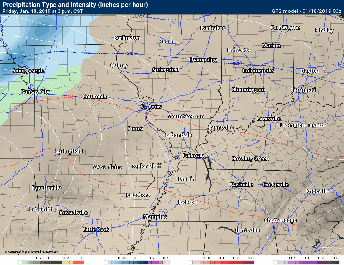
Rain, snow, and a wintry mix.
Model animations.
Rain chances will ramp up Friday night into Saturday.
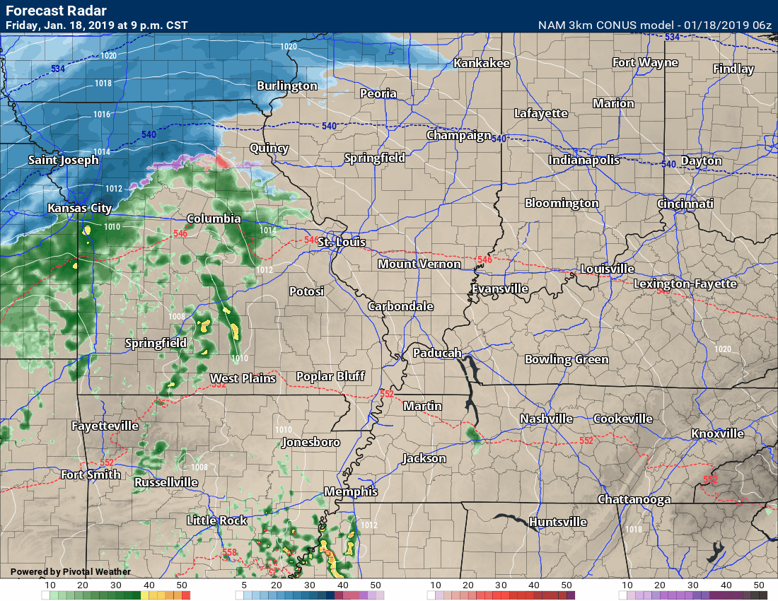
Let’s look at the NAM 3K model guidance future-cast radar.
This is what radar may look like as we push into Friday night and Saturday.
Widespread precipitation will develop along an incoming cold front.
Some locally moderate to heavy rain will be possible. I can’t rule out a few thunderstorms. The risk of severe weather is low.
Timestamp upper left.
You can see there is the chance the rain changes to a brief period of a wintry mix Saturday afternoon and night.
Green and yellow would be rain. Blue is snow. Purple and red are a wintry mix.
GFS model (another model)
Green and yellow would be rain. Blue is snow. Purple and red are a wintry mix.
EC model guidance
Green and yellow would be rain. Blue is snow. Pink, purple, orange, and red are a wintry mix.
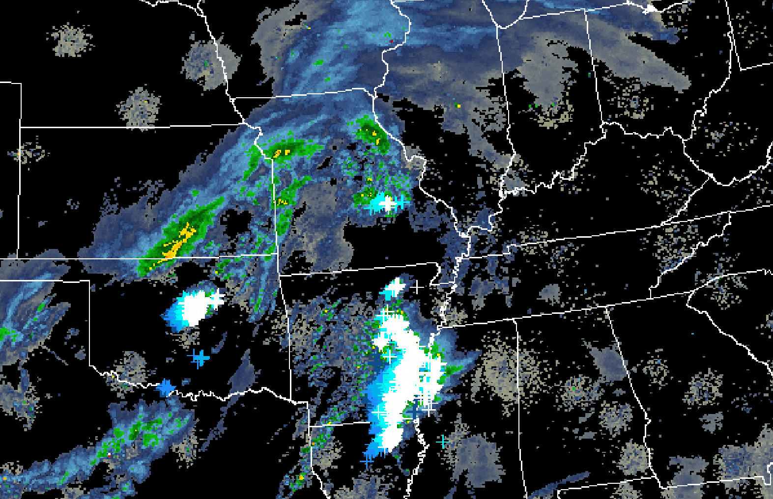
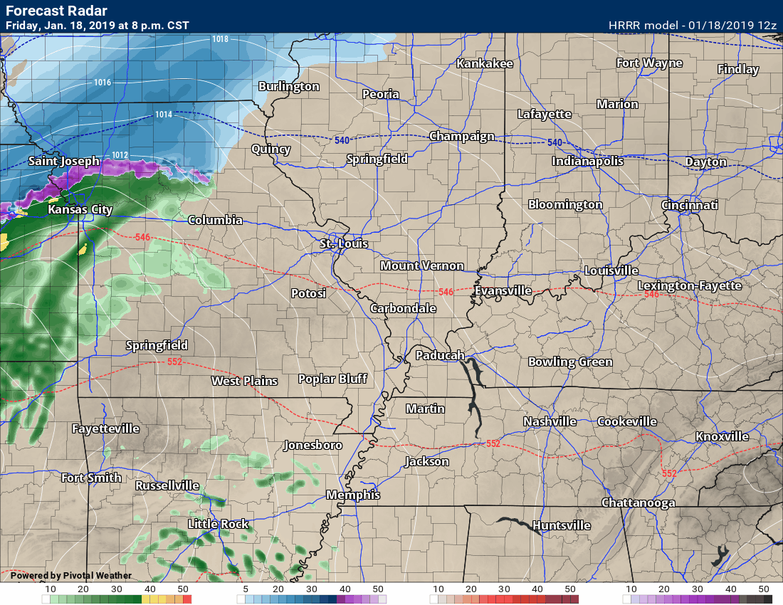
Here is the Hrrr model guidance.
Green is rain. Yellow and orange colors are locally moderate to heavy rain. Blue is snow.
Those dark blue colors are heavy snow. Wind-driven snow. We will need to closely monitor the track of the system.
It is that back end snow that we will have to concern ourselves with.
The main band of snow will remain across parts of central and northern Missouri, Iowa, and then eastward into parts of Michigan, Illinois, and Indiana.
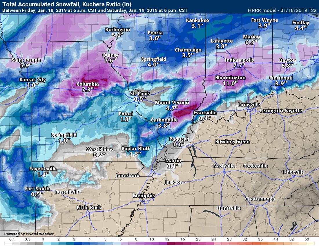
Snow totals from the Hrrr model guidance
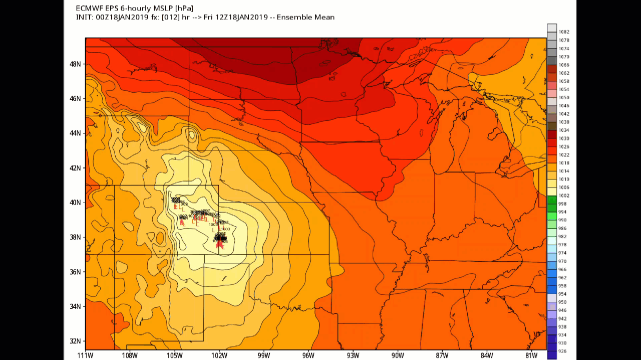
The EC model guidance shows the area of low pressure near our region.
Remember, the coldest air is positioned north and west of an area of low pressure.
Click to enlarge. The little red L’s are where the 50 ensemble members track the area of low pressure.
The more closely clustered they are the more confidence in the eventual track. These are closely clustered. That adds some confidence that the area of low pressure will track across our region.
Date-stamp upper left.
Here is the EC Model guidance graphic that shows you the chance of three or more inches of snow.
This model is not all that confident about snow in our local area.
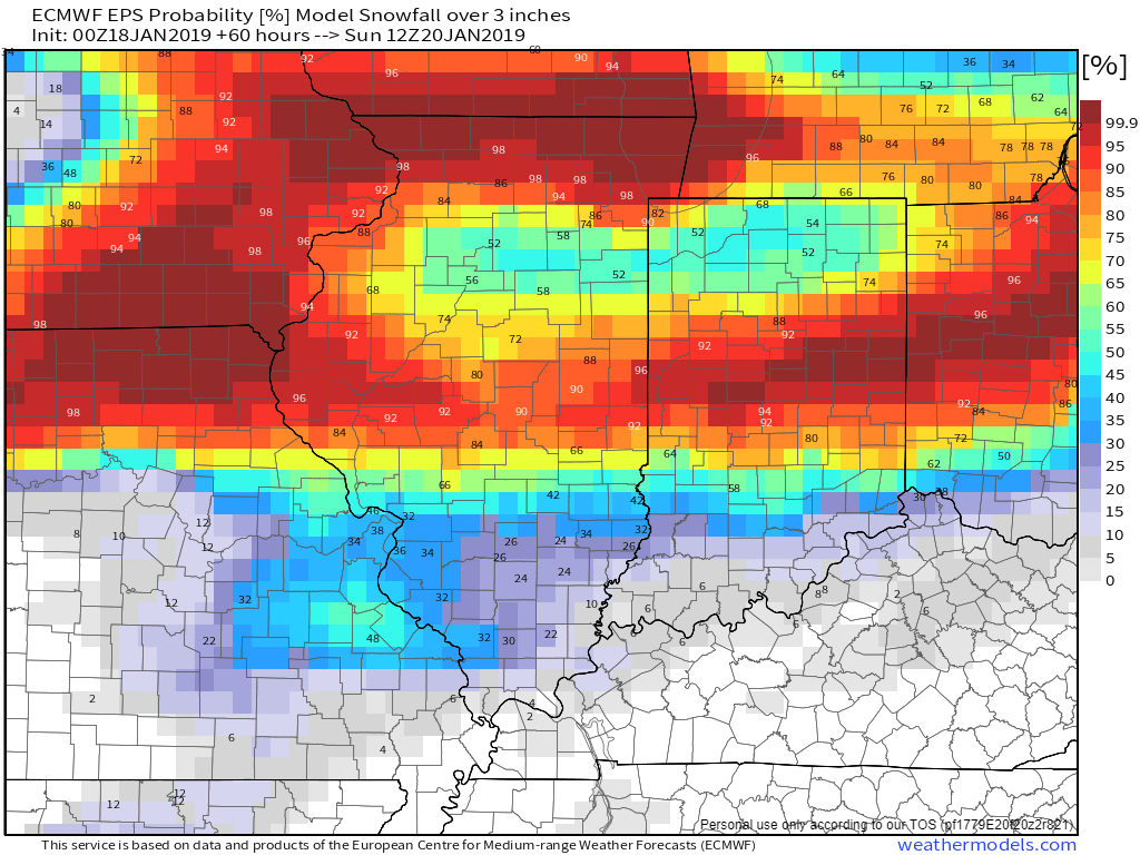
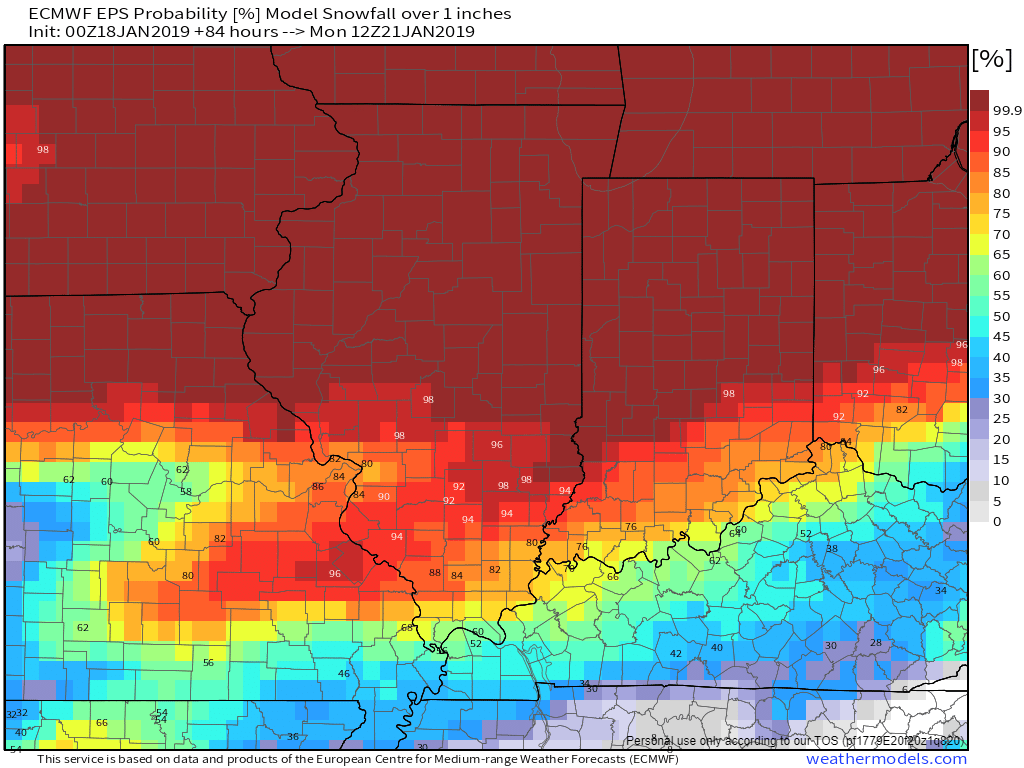
Let’s lower the totals a bit.
What are the chances of one or more inches of snow falling?
Confidence increases in the lower totals.
Snow and ice discussion.
The big question centers around the potential of snow and ice with this event.
The main band of snow with this event will track well to our north.
What I am monitoring is the potential of a second band of snow and wintry mix that should develop across portions of southern Missouri into Northern Arkansas. That band would then form and move east/northeast across a portion of our local area.
Confidence in the overall details remains low.
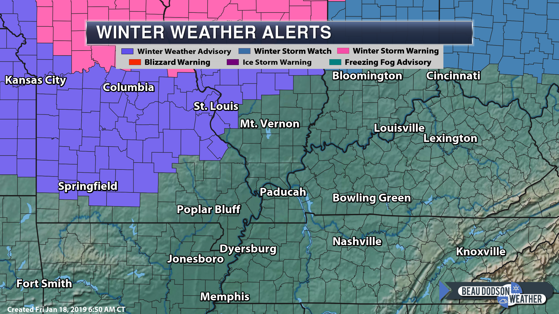
Here are the latest watches and advisories.
I already have a winter weather alert for the area (see the top of the page for the daily details).
Our area may eventually be added to the list of counties included in the “official” advisory/watch/warning zone from the NWS.
That is up to the NWS.
I do believe and I am forecasting some icy roads.
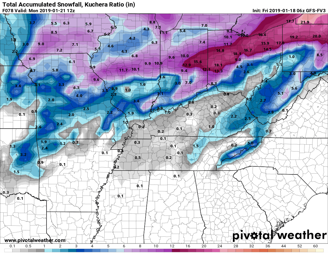
Snow totals from the different model packages.
These are snow totals that are being forecast by the different models.
Keep in mind, sleet is also possible.
Huge differences. This is because the models don’t know where to track the area of low pressure.
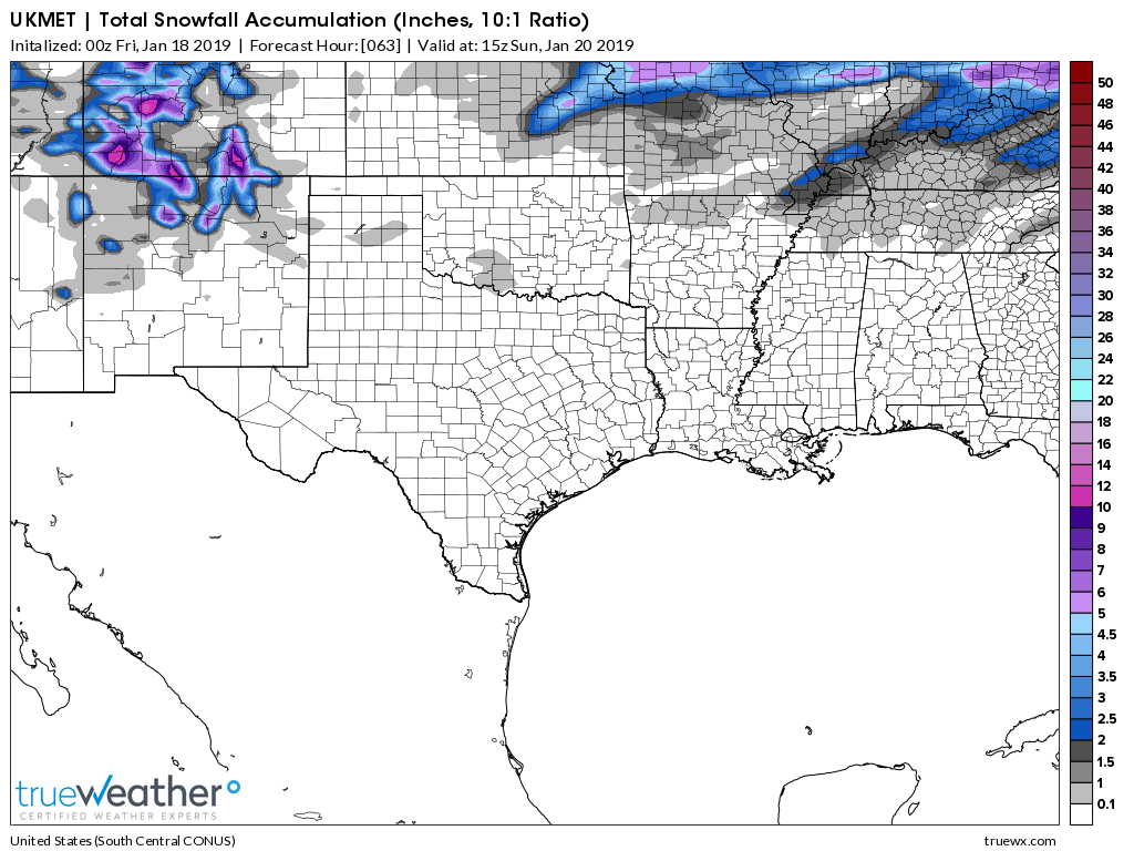
UKMET Model
The UK model is further south than the other guidance. This is currently an outlier. I will monitor the trends in the guidance.
See that little finger of higher totals locally?
That is what I am closely monitoring. Almost all the upper air charts support some burst of heavier snow totals in our region.
NAM model
NAM 3K
GFS
GFS (new version)
Canadian
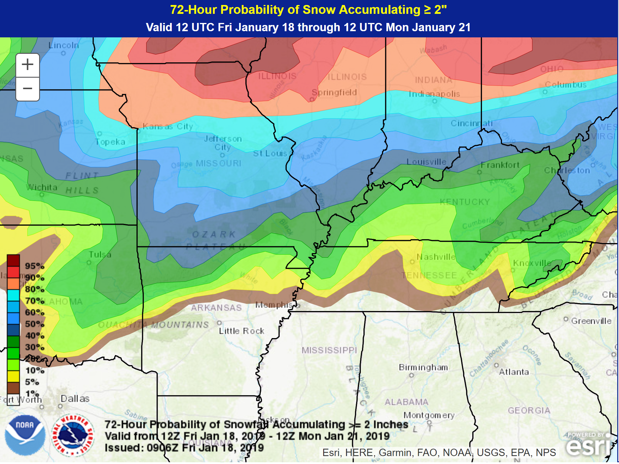
The WPC has posted this probability graphic for Saturday and Sunday. You can see where they have higher odds of wintry precipitation.
Let’s monitor this, as well. Let’s see if it shifts north or south with time.
This is where they see the probabilities for two or more inches of snow.
Another cold front arrives Tuesday and Wednesday.
Rain will accompany a cold front Tuesday and Tuesday night. This may end by Wednesday morning.
We could see this change to a wintry mix, as well.
The guidance also hints at a weaker system Wednesday night/Thursday and gain over the weekend.
There is plenty of weather to monitor over the coming weeks.
The February temperature outlook has been updated
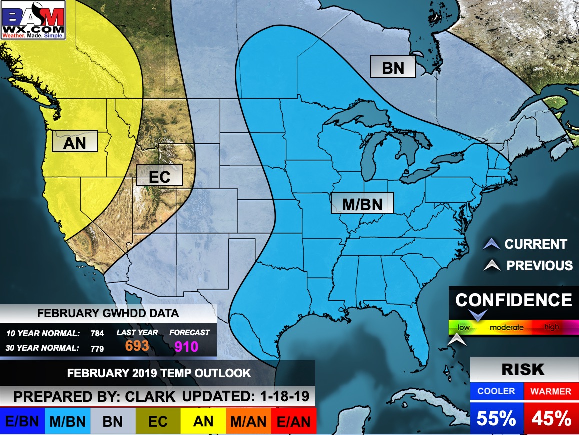
Click to enlarge
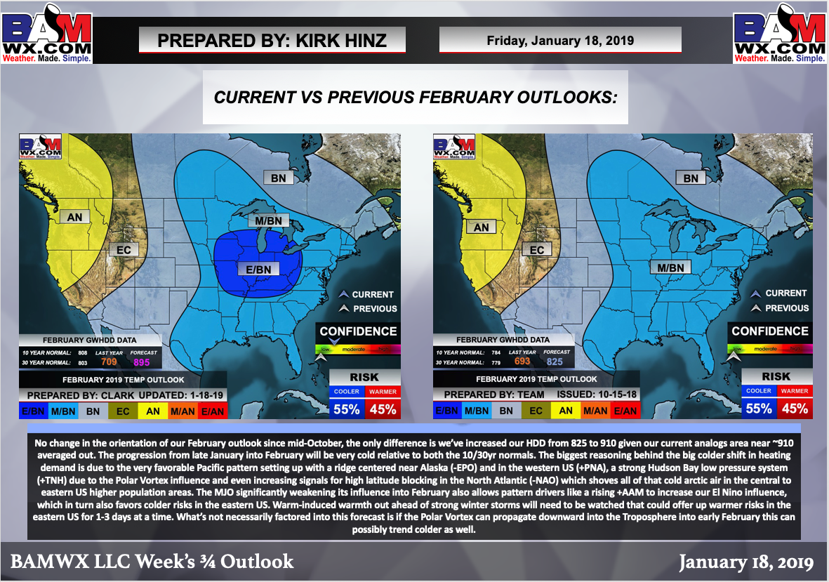
Here is the latest WPC 6 to 10 and 8 to 14-day temperature outlooks. This is a big change from what we have been experiencing over the last six weeks.
Below normal temperatures are likely as we move into the weekend and into the next few weeks.
Days 6 through 10
The blue colors indicate below normal temperatures. The darker the blue the greater the chance of below normal temperatures.
Days 8 through 14
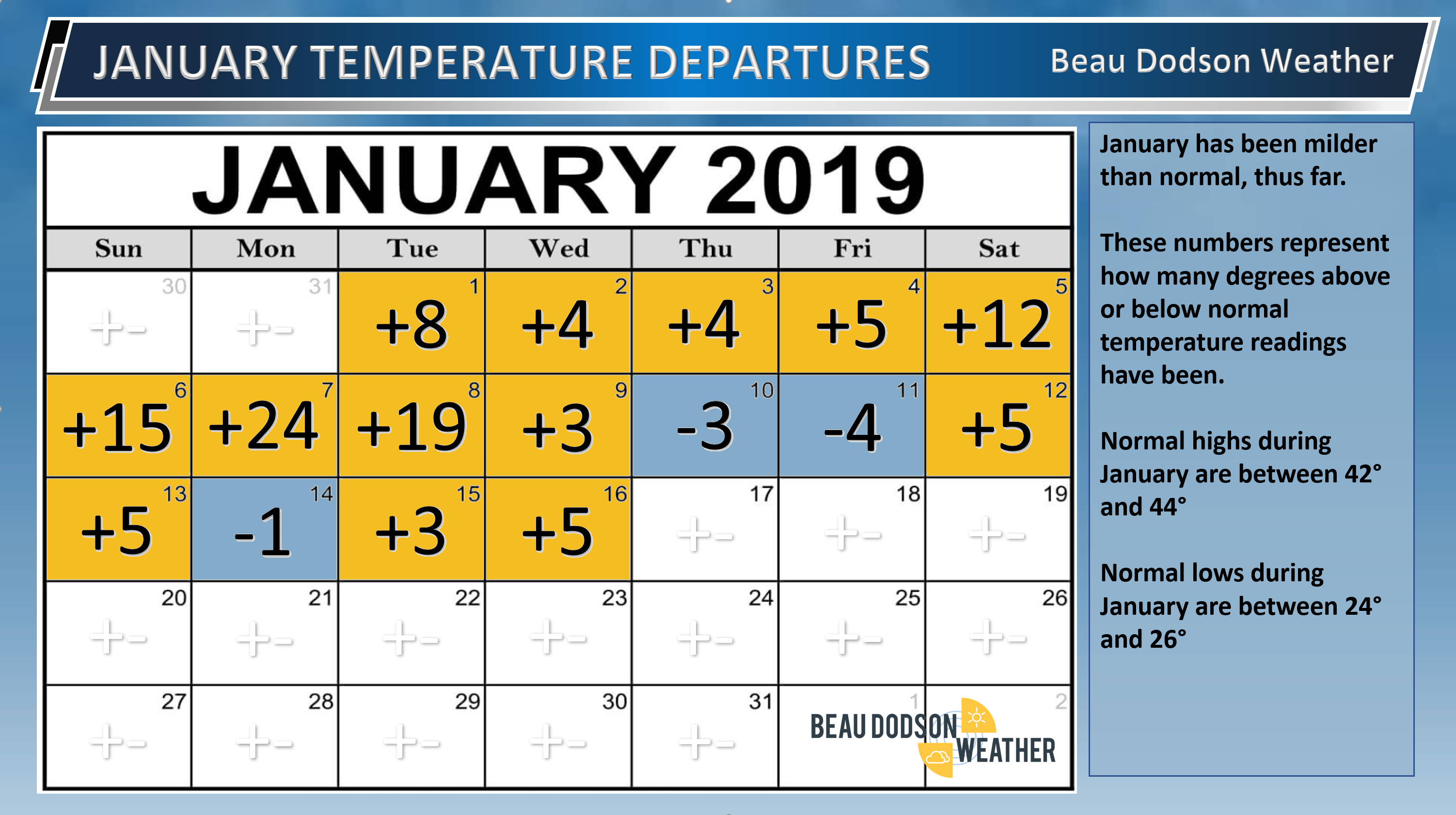
January, thus far, has certainly been mild. That may be about to change over the coming weeks.
We have several shots of cold air coming down the pike.
Here are the daily temperature anomalies, thus far.
Long Range Temperature Anomaly Forecast
Let’s look at the temperature anomaly forecast map from the long-range GFS model guidance.
This graphic shows you whether temperatures are forecast to average above or below normal.
Red shades indicate above normal temperatures. Dark red to pink indicates much above normal temperatures.
Blue shades represent below normal temperatures. Purple to pink represents much below normal temperatures.
The time-stamp is located in the upper left portion of the map animation.
Click the image to enlarge it.
![]()
VIDEO UPDATES
These are bonus videos and maps for subscribers. I bring these to you from the BAMwx team. I pay them to help with videos.
The Ohio and Missouri Valley videos cover most of our area. They do not have a specific Tennessee Valley forecast but they may add one in the future.
The long-range video is a bit technical. Over time, you can learn a lot about meteorology from the long range video.
NOTE: These are not updated on Saturday or Sunday unless there is active weather.

KEEP IN MIND
THE VIDEOS ARE MADE BY THE VIDEO TEAM.
THEIR FORECAST CAN VARY A BIT FROM MINE.
.KEEP


.
The Missouri Valley video (is usually updated during the late morning hours)
.
![]()

Here is some discussion from the BAMwx team.
Of course, this is the long-range and confidence in the finer details will remain low.
Remember, long-range outlooks are always going to be a lower confidence level than short-term forecasts.
Long-range forecasting is not an exact science. There are many variables that determine the eventual outcome of a long-range forecast.

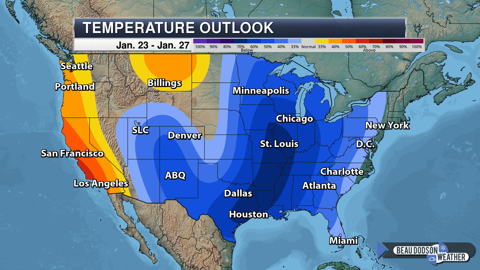
Normal high temperatures for this time of the year are around 43 degrees.
Normal low temperatures for this time of the year are around 26 degrees.
Normal precipitation during this time period ranges from 0.65″ to 0.90″
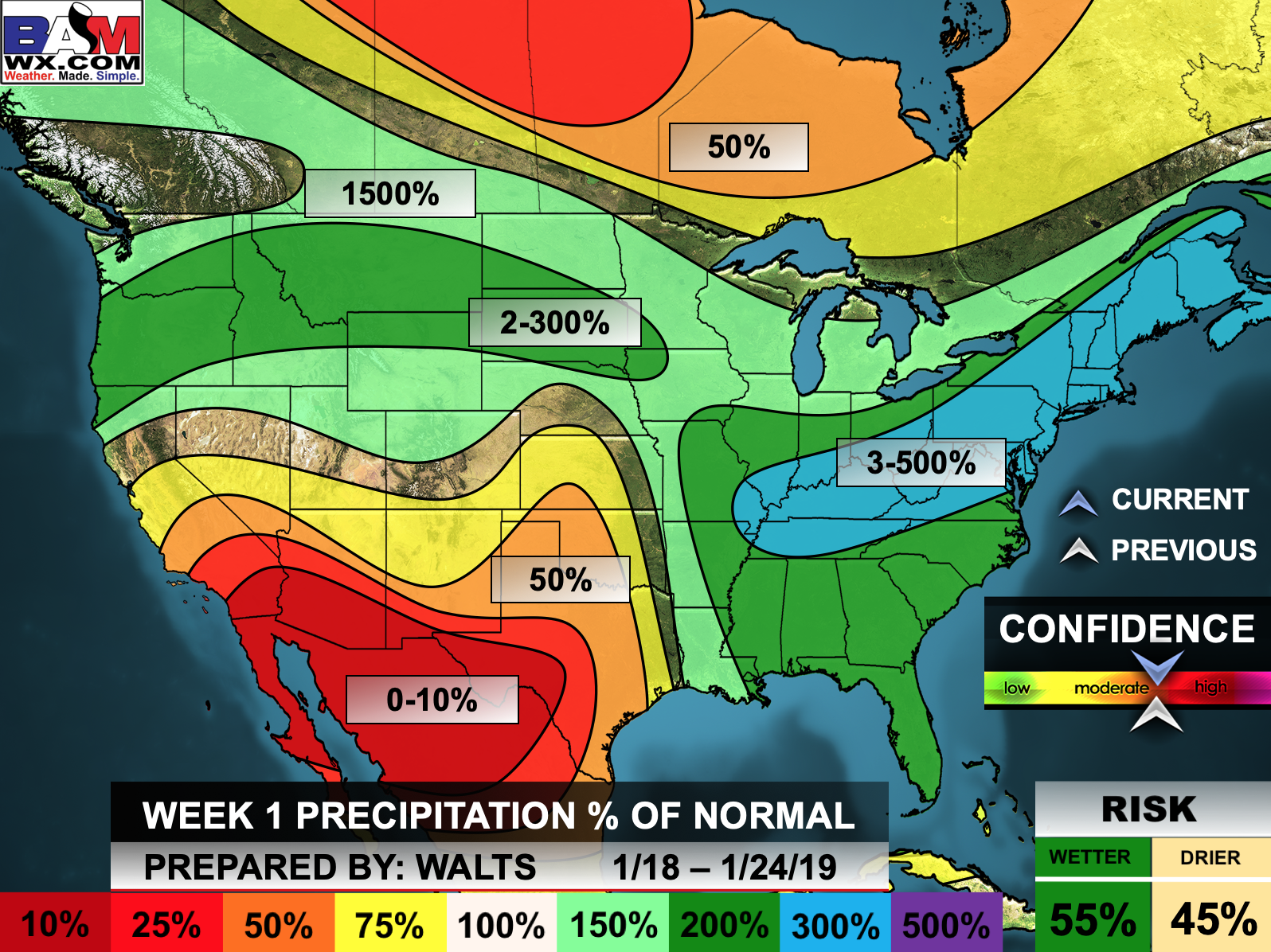
This outlook covers January 18th through the 24th
Click images to enlarge them.
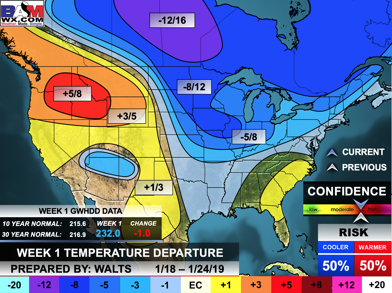
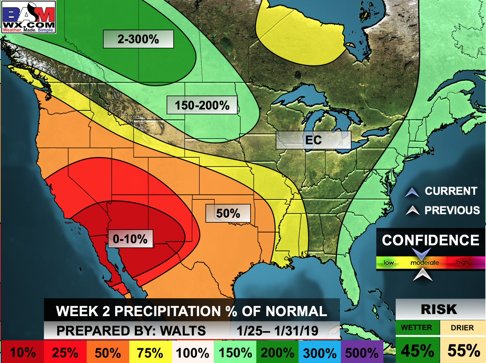
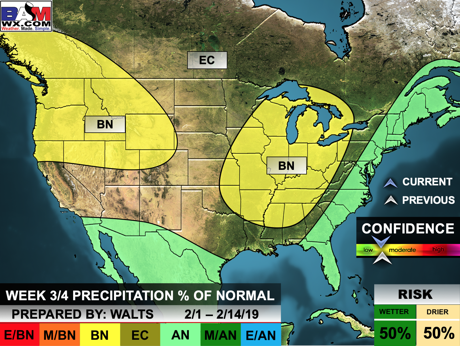
The precipitation forecast is PERCENT OF NORMAL. For example, if your normal rainfall is 1.00″ and the graphic shows 25%, then that would mean 0.25″ of rain is anticipated.

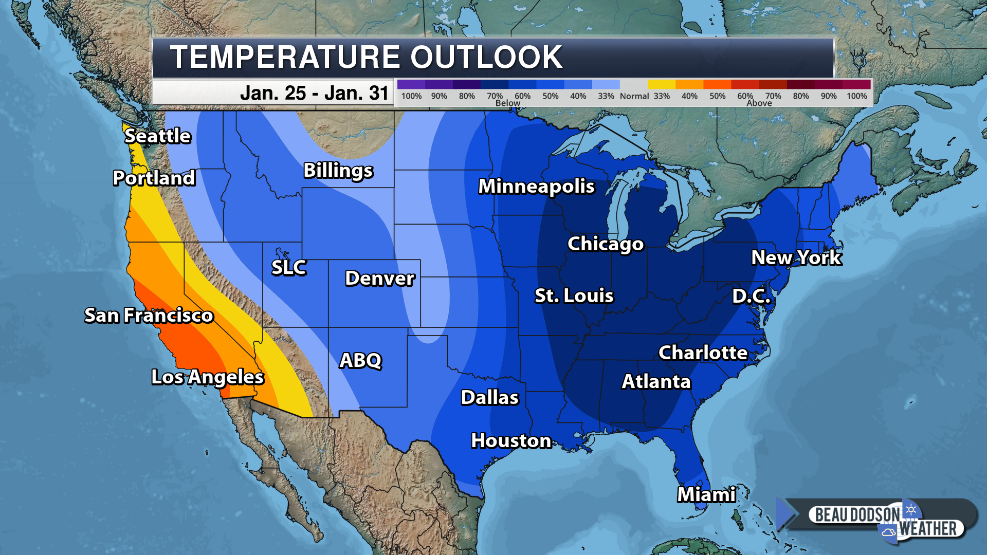
Normal high temperatures for this time of the year are around 42 degrees
Normal low temperatures for this time of the year are around 25 degrees
Normal precipitation during this time period ranges from 0.70″ to 0.90″
This outlook covers January 25th through January 31st
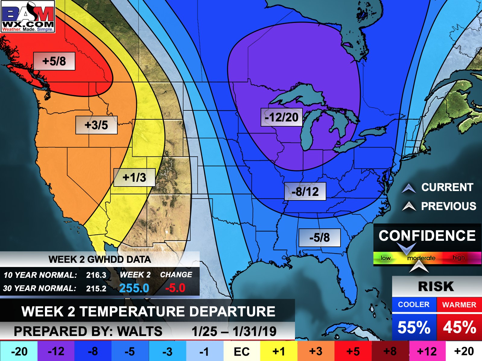
The precipitation forecast is PERCENT OF NORMAL. For example, if your normal rainfall is 1.00″ and the graphic shows 25%, then that would mean 0.25″ of rain is anticipated.

Outlook definitions
EC = Equal chances of above or below normal
BN= Below normal
M/BN = Much below normal
AN = Above normal
M/AN = Much above normal
E/AN = Extremely above normal
Normal high temperatures for this time of the year are around 44 degrees
Normal low temperatures for this time of the year are around 26 degrees
Normal precipitation during this time period ranges from 1.40″ to 1.80″
This outlook covers February 1st through February 14th
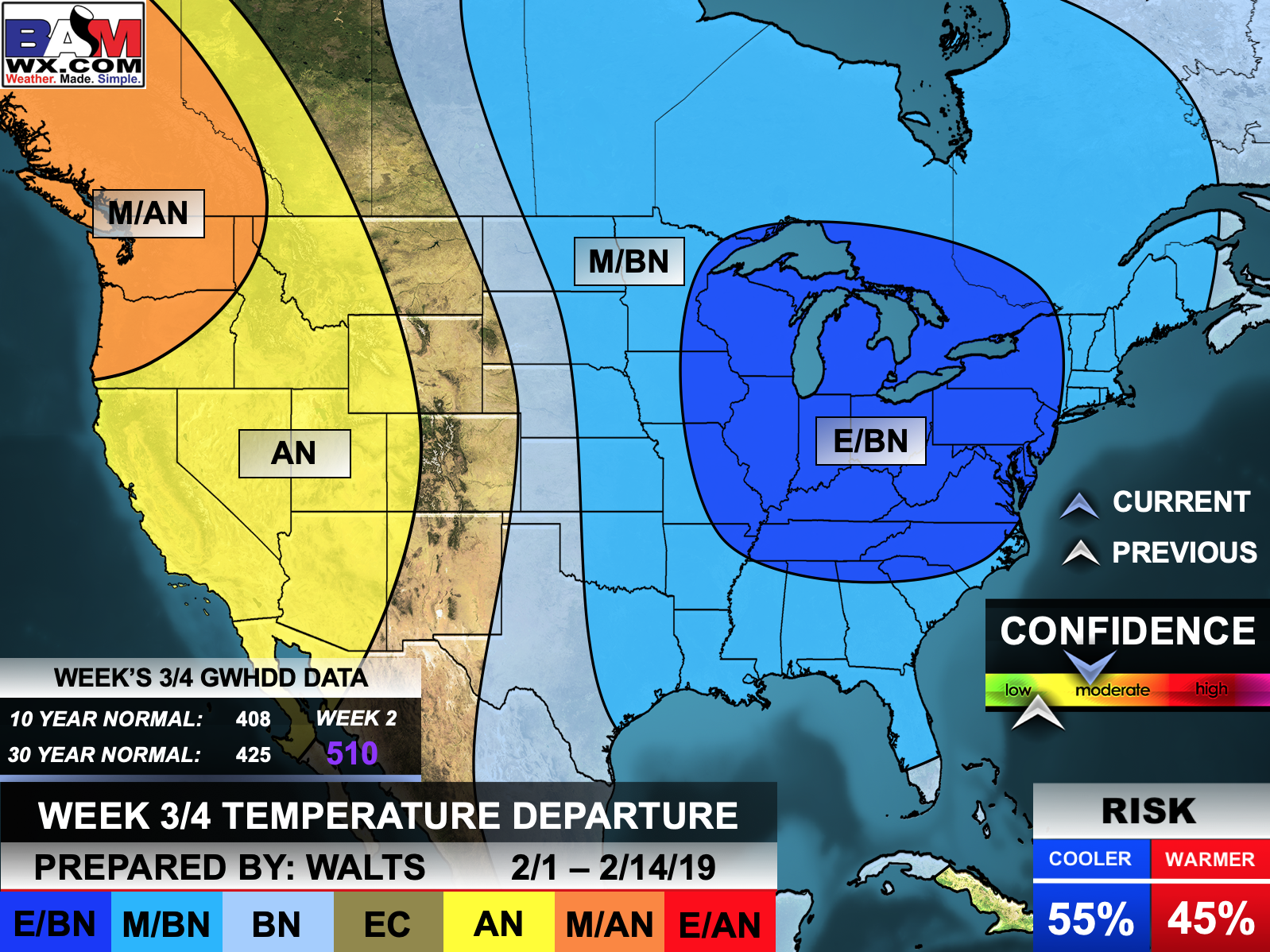
The precipitation forecast is PERCENT OF NORMAL. For example, if your normal rainfall is 1.00″ and the graphic shows 10%, then that would mean 0.10″ of rain is anticipated.
![]()
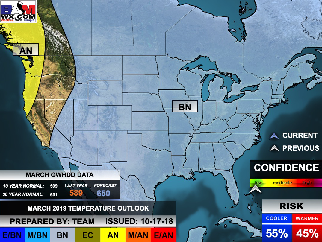
March Temperature Outlook
![]()

A new weather podcast is now available! Weather Geeks (which you might remember is on The Weather Channel each Sunday)
To learn more visit their website. Click here.
![]()

WeatherBrains Episode 678
Tonight’s show won’t feature any guests, so the panel has extra time to RANT! Tonight’s discussion mainly focuses on the current 2019 ongoing government shutdown.
Other discussions in this weekly podcast include topics like:
- How will the 2019 shutdown affect the weather enterprise?
- A major winter storm stretching from Midwest to DC
- Discussion of Saffir-Simpson scale
- Reductionist communication methods in broadcast meteorology
- Signs of an early start to tornado season???
- The Astronomy Report from Tony Rice
- and more!
Link to their website https://weatherbrains.com/
Previous episodes can be viewed by clicking here.
Find me on Facebook!

Find me on Twitter!

Did you know that a portion of your monthly subscription helps support local charity projects?
You can learn more about those projects by visiting the Shadow Angel Foundation website and the Beau Dodson News website.
