![]()
Suggestions for receiving severe weather warnings
1. Do not rely on social media for your weather watches and warnings. Social media should be your last resort for severe weather warnings.
2. Own a Midland NOAA Weather Radio. I suggest the Midland Model 300.
3. Have multiple avenues for severe weather information. That would include a NOAA Weather Radio, local media, weather warning app’s, telephone services that call you when a warning is issued for your location, and text services. It is best to have at least 3 ways of receiving your severe weather warnings.
4. Do not rely on the outdoor sirens for your warning. They could fail, they require a human to set them off, and you might not be able to hear them because of the intensity of the storm. The outdoor warning sirens should be a supplement to your other sources for information.
5. Always check the time stamps on radars and other weather products.
Tornado Watch/Warning – Conditions are favorable for the development of severe thunderstorms and tornadoes in and close to the watch area. These watches are issued for large areas by the Storm Prediction Center in Norman, Oklahoma, and are usually valid for five to eight hours.
Severe Thunderstorm Watch/Warning – Conditions are favorable for the development of severe thunderstorms in and close to the watch area. A severe thunderstorm contains large damaging hail of 3/4 inch (20 mm) diameter or larger, and/or damaging winds greater than 58 mph (95 km/h or 50 knots) or greater. Isolated tornadoes are also possible but not expected to be the dominant severe weather event. These watches are issued for large areas by the Storm Prediction Center in Norman, Oklahoma, and are usually valid for five to eight hours.
(Flash) Flood Watch/Warning – Conditions are favorable for (flash) flooding in and close to the watch area. These watches are issued by the Weather Forecast Office and are usually issued six to twenty-four hours in advance of expected flood potential. In Canada, a Heavy Rainfall Warning has a similar meaning.
Flood Watch/Warning – General or areal flooding of streets, low-lying areas, urban storm drains, creeks and small streams is occurring, imminent, or highly likely. Flood warnings are issued for flooding that occurs more than 6 hours after the excessive rainfall. These warnings are issued on a county by county basis by the local Weather Forecast Office and are generally in effect for 6 to 12 hours.
What’s a watch? Video – click here
The best tornado safety videos online – click here
Here are some storm tracking tools. I will give you duplicate ways of receiving information. If one fails then try another. If some radars don’t load then try another link. I will provide you with multiple links.
Always check the time stamps on radars and other data. Make sure you have the latest information.
![]()

Click the map and drill down to your county. Refresh the maps often.
The National Weather Service posts warnings on their home pages. Click your local office for a watch/warning map. Remember that multiple watches and warnings could be in effect at any given time. Click your county to view the latest information.
Paducah, Kentucky National Weather Service
St Louis, Missouri National Weather Service
Memphis, Tennessee National Weather Service
Nashville, Tennessee National Weather Service
Springfield, Missouri National Weather Service
Louisville, Kentucky National Weather Service
National Map of all National Weather Service Offices
Second Feed for the National Weather Service multi-media videos
Beau Dodson’s Social Feed – you can monitor my Twitter, Facebook, and the NWS out of Paducah, KY
Additional sources for severe weather warnings
Wunderground National Warning Map – click your area
Current Severe weather and flood warnings

We have regional radars and local city radars – if a radar does not seem to be updating then try another one. Occasional browsers need their cache cleared. You may also try restarting your browser. That usually fixes the problem. Occasionally we do have a radar go down. That is why I have duplicates. Thus, if one fails then try another one.
If you have any problems then please send me an email beaudodson@usawx.com
Main WEATHER RADAR PAGE – Click here —
We also have a new national interactive radar – you can view that radar by clicking here.
Local city interactive radars – click here
NOTE: Occasionally you will see ground clutter on the radar (these are false echoes). Normally they show up close to the radar sites – including Paducah.
WSIL 3 Interactive Radar – Click here
KFVS 12 Interactive Radar – Click here
WPSD 6 Interactive Radar – Click here
National Weather Service Radar Page – click your area and it will zoom down to a local radar
College of Dupage Radars – note the product menu in the upper left corner of the radar.
Additional Radars from the College of Dupage Radar Page
Wunderground Radar Maps – click your local radar
Intellicast Radar Maps – Click your local area
Track Mesocyclone and Hail Swaths

Live Lightning Data – zoom and pan: Click here
Live Lightning Data with sound (click the sound button on the left side of the page): Click here

For the most up to date maps – click here
Day 1 Severe Weather Outlook from the Storm Prediction Center – Storm Prediction Center
What does thunderstorms, marginal, slight, enhanced, medium, and high risk mean? Click here
A more in-depth discussion about the new risk color coding – click here
Here is a great post that goes into detail about the new category levels…Click here
More information on Storm Prediction Center Products – click here
Tornado Probabilities – what are the chances of a tornado within 25 miles of your location?

Tornado Probabilities Within 25 Miles of your location
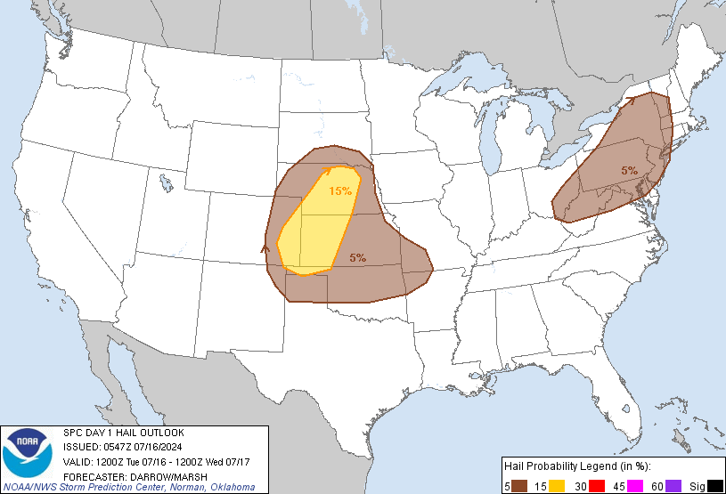
Large Hail Probabilities (below)

Probability of large hail within 25 miles of your locaton
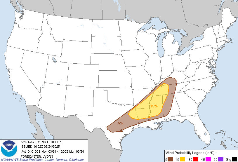
Damaging wind forecast (winds greater than 58 mph). Chances of damaging winds within 25 miles of your location.

Probability of damaging winds within 25 miles of your location
For the most up to date maps – click here
The maps below are an alternative way of looking at the situation. As always, trying to explain probabilities is a complex problem. Remember, it only takes one tornado to cause problems.


Current Severe thunderstorm and tornado watches from the Storm Prediction Center. The Storm Prediction Center is in charge of issuing watches. Our local National Weather Service Office in Paducah, Kentucky is in charge of issuing warnings.
Remember that a watch means that conditions are favorable for severe weather. Severe weather MIGHT develop over the coming hours. Watches normally last 4 to 8 hours. Monitor updates for possible warnings. A watch is a step below a warning.
A warning means to take immediate action to protect you and your family. Warnings usually last from 15 to 45 minutes. A warning means that a storm is moving into your area.
For additional watch information click here

Severe thunderstorm and tornado watches
Latest Mesoscale discussion. A mesoscale discussion is sometimes issued before a severe thunderstorm or tornado watch is issued. They can also be issued to give an update on what is happening within a watch.
Additional source to view the Storm Prediction Center’s latest severe weather outlook
SPC Tornado Environment Numbers
SPC Enhanced Thunderstorm Outlook
Experimental Tornado Forecast Model – Click here
SPC Storm-Scale Ensemble Forecast Model
NCEP WRF SPC Model 00z Run
NCEP WRF SPC Model 12z Run
SPC WRF – with multiple zoom areas

Listen to local storm spotters and scanner feeds

Don’t forget to check out the Southern Illinois Weather Observatory web-site for weather maps, tower cams, scanner feeds, radars, and much more! Click here
People that I recommend you follow on Facebook
Remember that I don’t recommend you use Facebook for instant weather information/warnings. Use Facebook to give you an idea of what is going to happen. When actual severe weather develops then nothing can beat your NOAA Weather Radio, your weather warning app’s, and local wall to wall coverage by a local tv or radio station.
Here is a page with a lot of individuals you can follow for information – click here
Jim Rasor WSIL
https://www.facebook.com/jimrasorWSIL
Nick Hausen WSIL
https://www.facebook.com/NickHausenWSIL
KFVS Weather Updates
https://www.facebook.com/pages/KFVS-Weather-Alerts/115396855151075
Grant Date KFVS Weather
https://www.facebook.com/grantdadekltv
Laura Wibbenmeyer KFVS
https://www.facebook.com/pages/Laura-Wibbenmeyer-KFVS/218679261517716
Paducah, KY NWS
https://www.facebook.com/US.NationalWeatherService.Paducah.gov
Follow them on Twitter, as well
https://twitter.com/NWSPaducah
If you live east of Kentucky Lake then try Chris Allen on Twitter
https://twitter.com/ChrisAllenSkywx
Jason Darnall Weather
https://www.facebook.com/pages/Jason-Darnall-Weather/229266320576270
Evansville area – Maurice Shamell
https://www.facebook.com/MoeWx
Jacob Wilkins
https://www.facebook.com/jacob.wilkins.395?fref=ts
Jennifer Rukavina
https://www.facebook.com/JenniferRukavinaWPSD
WPSD Weather Page
https://www.facebook.com/WPSDWeather
Lew Jetton can be heard on the radio, as well
Most of the time he is live on NewsTalk 94.3, 95.5FM (Mayfield) and 570 and 1320 on AM. He also occasionally does inserts on WKYQ FM 93.3, WLLE FM 102.1 and WQQR FM 94.7.
Dr Greg Forbes The Weather Channel
Consider a radar APP for your cell phone (these are the 2 that I use) – there is a minimal cost for the radar APP’s below
http://radarscope.tv/
I also use
http://www.pykl3radar.com/
Some additional app’s that I recommend
Here are some App’s that I recommend to help keep your family safe during storms. I recommend everyone have 3+ sources for their warning information. Do not count on Facebook for your severe weather information. Facebook is great for a general “heads up” about incoming weather. But, I would not rely on it for your actual warnings.
Storm Shield APP – great for severe weather warnings. It uses your exact location for the warning. If you are not in the warning then you will not be notified of the warning.
http://stormshieldapp.com/
Another great APP is Imap Weather Radio – it will alert you for severe weather warnings in your area.
http://imapweatherradio.com/
I recommend the Midland Model 300 weather radio – be sure and spend the extra money for the 300 model. This model will allow you to program the radio to alert you for specific warnings. If you don’t want amber alerts then you can program those out. If you don’t want flash flood warnings then you can program those out. Or you can program it to alert you for all severe weather products. This weather radio allows you to choose. This is nice because some people complain about their weather radios going off for too many products. This is the model I use in my house. You can normally find this weather radio on Amazon for $35-$45.00. Don’t pay a lot more than that (I have seen them for sale for over $80.00).
Another great service that will call your home phone or cell phone in the event your home or location is placed in a severe thunderstorm or tornado warning
http://www.weathercallservices.com/
Tornado and Severe Weather Safety Videos
http://stormaware.mo.gov/

You can sign up for my AWARE email by clicking here I typically send out AWARE emails before severe weather, winter storms, or other active weather situations. I do not email watches or warnings. The emails are a basic “heads up” concerning incoming weather conditions.


