We have some great sponsors for the Weather Talk Blog. Please support them when you have the opportunity.
Milner and Orr Funeral Home and Cremation Services located in Paducah, Kentucky and three other western Kentucky towns – at Milner and Orr they believe in families helping families. You can find Milner and Orr on Facebook, as well.
![]()

This forecast update covers far southern Illinois, far southeast Missouri, and far western Kentucky. See the coverage map on the right side of the blog.
Remember that weather evolves. Check back frequently for updates, especially during active weather.
The forecast numbers below may vary quite a bit across the region. These are averages.
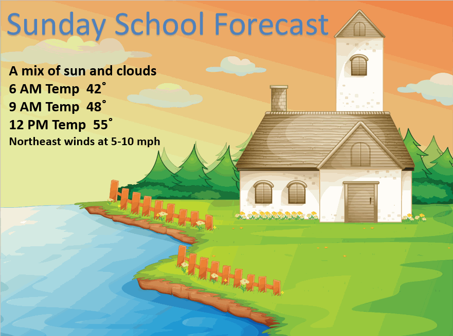
Sunday – A mix of sun and clouds. Small chance for a sprinkle far southern counties. Cooler over our northern counties vs southern counties. Highs mostly in the 50’s up towards Mt Vernon and over towards IL/IN line. 60’s elsewhere. Overall, not a bad day for early spring. Light winds from the northeast at 5-10 mph. My confidence in this part of the forecast verifying is high
Sunday night – Some clouds. Chilly. Lows mostly in the 30’s but perhaps near 40 along the KY/TN line and the Missouri Bootheel. Light winds from the east/northeast at 5 mph. My confidence in this part of the forecast verifying is high
Monday – Some clouds, again. Quite a few clouds over the coming days. Chance for a light shower over northern and northeastern counties. Mild temperatures. Morning temperatures will start in the 30’s and near 40 but rise into the 50’s and 60’s during the afternoon. Warmest temperatures will be over far southern Illinois, southeast Missouri, and west KY/TN. A bit cooler (the 50’s) for far northern counties in the area. Winds from the east at 5-10 mph with gusts to 15 mph. My confidence in this part of the forecast verifying is high
Monday night – Some clouds. Small chance for a shower. Mild with lows mostly in the 40’s. South/southwest winds at 10 mph. My confidence in this part of the forecast verifying is high
Tuesday – Partly sunny and mild/warm and more humid. A chance for a shower or thunderstorm far northern and northwestern counties – more towards St Louis area vs our local area. But, a few showers/storms could stray south and east a bit. Another chance for a shower/storm over northeastern counties – closer to IL/IN border, as well. Small chances overall. Will monitor trends on the data. Overall, most of the area should be dry. Highs well into the upper 60’s to middle 70’s. Southerly/southwesterly winds will pick up at 10-20 mph. Gusty at times. My confidence in this part of the forecast verifying is medium

Current Temperatures Around The Local Area


Don’t forget to check out the Southern Illinois Weather Observatory web-site for weather maps, tower cams, scanner feeds, radars, and much more! Click here

An explanation of what is happening in the atmosphere over the coming days…
Highlights
1. Some very mild days ahead of us. Tuesday will be warm with widespread 70’s.
2. Best chances for showers and thunderstorms will be Tuesday night into Wednesday night. Centered on Wednesday afternoon and night. A few storms could produce gusty winds. Monitor updates. There is some question on the placement of precipitation with the front (see below for details)
3. Stalled out front might mean additional rain chances Thursday and Friday (although confidence is lower)
4. Colder air returns late week.
Some of you don’t use Facebook, so I will re-post here (my thoughts on the past winter)
HAPPY FIRST FULL DAY OF SPRING! Woohooooo. We made it. I know some of you wanted to give up a long time ago. You whined and moaned about the cold, snow, and ice. But, we tolerated ya. We kept telling you to keep your eye on the prize…even in the snowiest of moments.
Many of your rickety wagons broke down along the trail. There were a few occasions when the icicles were hanging so low under the covered wagon that they were dragging the ground. But we didn’t let that stop us. Nope. We picked ya up and stuffed ya into the next wagon. It was crowded from time to time. But, singing folk songs kept our spirits up. Although honestly I don’t think I could handle one more verse of She’ll be coming ’round the mountain when she comes. Thank ya very much.
We found plenty of wild game along the way to keep our stomachs full. Sure, the meat was frozen from time to time…but we sucked it up and warmed it over the open fire.
We had to circle back and even pick a few of you up (those blinding zero visibility snowstorms do make it hard to find the outhouse – so we don’t blame ya for gettin lost). But, we did it! We really did it. We made it over the pass into the promised land of spring.
And now, I want to especially thank all of those who cut me ropes loose. And I won’t hold it against ya that when the March snowstorm arrived you were going to burn me at the stake. I don’t blame ya…not one bit. But, calmer heads did prevail and ya set me free. So for that I am thankful.
Now just one word for all of you young whippersnappers that complained about how cold it was…I do not want to hear a peep out of ya this summer when the thermometer nips at 95. Not a word, I tell ya. Otherwise, next year you are walking. Forget the horses, forget the wagons, forget riding on daddy’s shoulders…you are walkin.

🙂
Okay, well enough fun! Let’s talk about the next few days.
A cold front is hovering near our region. That means cooler temperatures north of the front and warmer to the south of the front. The front is not going to move much over the next 24 hours.
Coolest temperatures will be over our northern counties. Let me show you what I mean
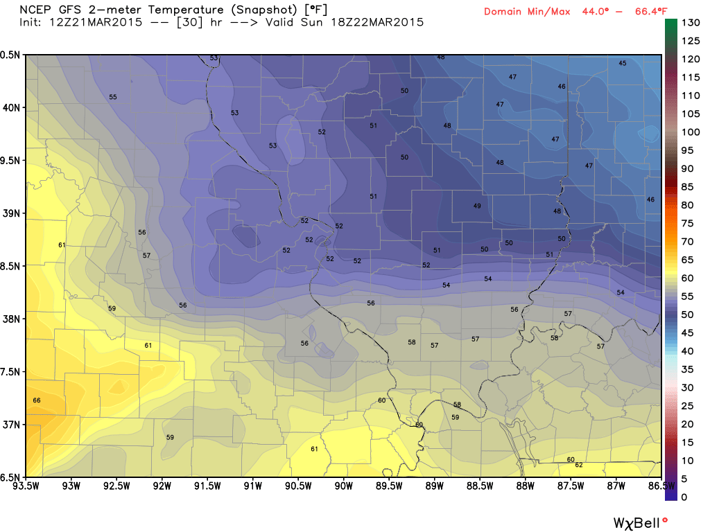
Here are the Sunday early afternoon temperatures (around noon). Not as nice as Saturday’s temperatures. But, by afternoon we should see some 60’s over the area (especially southern half). A bit cooler for our northern and northeastern counties.
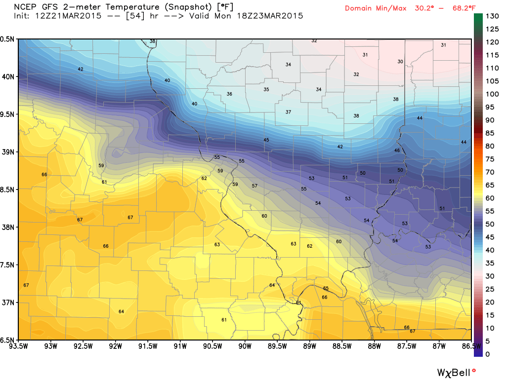
Here are the Monday noon temperatures (below). Notice how cool it is north of the front? 30’s over central Illinois. Brrr is all I can say. Thankfully we will be warmer than that. But, sharp gradient. Our northern and northeastern counties will be the coolest. Warmest air will be over our southern and southwestern counties.
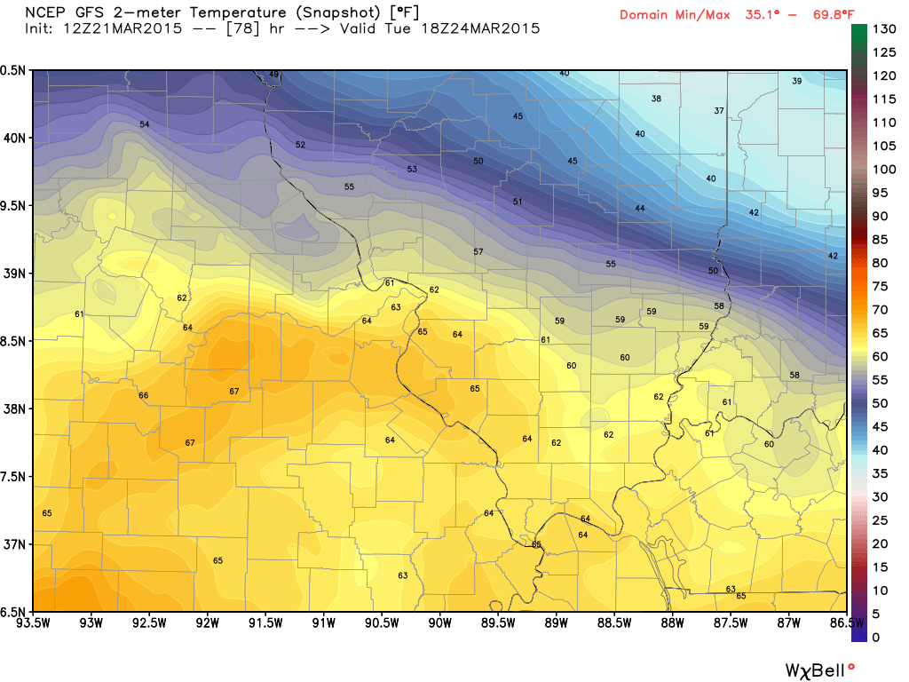
Let’s look at Tuesday’s temperatures – same idea (below). Cooler north and warmer south.
We will have a mix of sun and clouds over the coming days. Mostly dry. A weak system passes to our south on Sunday. Small chance for rain over northwest Tennessee and Missouri Bootheel (KY/TN border area). Perhaps a 10%-20% chance.
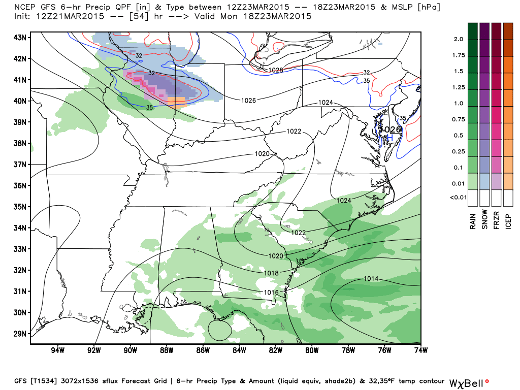
On Monday a rain/snow maker passes to our north. Remember at one point there was a chance for a rain/snow mix in our area? That is the system to our north. Thankfully we won’t have to deal with this. A front will stall out over our northern counties, thus the coldest air and rain/snow chances will be further north in Illinois and Indiana. Good for us, bad for them.
Here is what that looks like on the weather map for Monday (below). The green would be rain. Pink is sleet and freezing rain and the blue would be snow! Not too far away from us. Map is from weatherbell.com
A couple of weather systems move into the region Monday night into Thursday.
Some small chances for scattered precipitation Monday into Tuesday afternoon – mostly over our northern counties. But, keep this in mind – unsettled period of weather ahead of us. Lot of moisture will pool in the area along a stalled out front that will eventually turn into a warm front and push northward.
Small chance for a few showers and thunderstorms on Monday night along a warm front. This would likely be over our northern counties. I will monitor for any shift in the placement. Thinking areas along a line from Salem, Missouri to Mt Vernon, Illinois would have better chances for a shower or storm than say areas down in the Bootheel of Missouri or western Kentucky. Chances overall will probably scattered over our northern counties.
Normally when you have a warm front you look north of the front for precipitation to develop. This happens as warmer air flows up and over the front – over the cooler air to the north.
The next precipitation chance arrives on Tuesday. I believe the best chances for showers and thunderstorms on Tuesday will be over our northwestern counties. Perhaps more towards I44 and I64 in Missouri and Illinois. I will monitor this.
By Tuesday night a few of these showers and thunderstorms could make their way into our local area. This will be along a cold front that will move from west/northwest to east/southeast. Not expecting severe weather during this time period. But, some lightning and thunder will be possible. Remember that severe weather is defined as 58 mph winds, 1″ size hail, or tornadoes. That is the official definition of a severe thunderstorm.
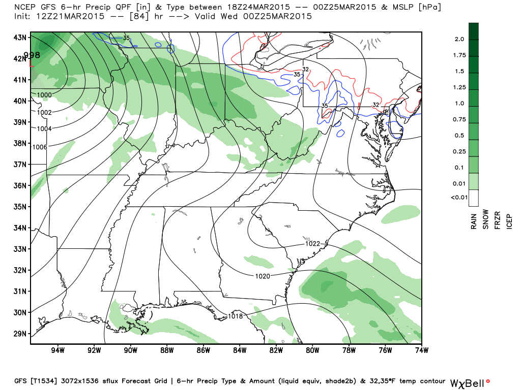
Here is the Tuesday evening weather map. The bulk of this precipitation will be out of our area. But, a few showers and thunderstorms could pop up locally. I will update as we move forward. Again, not expecting severe storms on Tuesday or Tuesday night in our local area. Map from weatherbell.com
See the extended discussion for Wednesday onward. Additional showers and storms likely on Wednesday afternoon and evening. A few strong storms possible.
Don’t forget to support our sponsors!

No major changes in this forecast package.

No major changes for the next 24 hours. Watching thunderstorm chances towards the middle of the new work week.
Check out our sponsors! There are more on the right side bar of the page, as well. Be sure and let them know that you appreciate their sponsorship of the WeatherTalk daily weather bulletin.
How about a $5 meal deal? The DQ Grill and Chill (located across from Noble Park in Paducah, Kentucky) is the newest WeatherTalk Blog sponsor! A local business helping to sponsor the weather information that you have come to love so much.
Check out their Facebook page for specials, as well DQ Grill and Chill on Facebook


Premier Portable Buildings proudly serving our region. For more information click the above ad or here
They can also be found on this Facebook page
G&C Multi-Services out of Paducah, Kentucky. G & C Multi-Services is a service provider in Western Kentucky that provides industrial and commercial equipment fabrication, machine troubleshooting, repair and maintenance, and installation. They can custom fabricate steel, stainless, and aluminum products per customer specifications.
Visit their web-site here. Or click the ad below! Facebook page.


Wortham Dental Care located in Paducah, Kentucky. The gentle dentist. Mercury free dentistry. They also do safe Mercury removal. You can find Wortham Dental Care on Facebook, as well

Trover’s Equipment and Lawn Care – Family owned and operated! They are a dealer for Snapper, Simplicity, Snapper Pro, Bad Boy Mowers, and Intimidator Utility Vehicles. They are a Stihl and Dolmar power products dealer. They also are a dealer for Briggs & Stratton, Kohler gas & diesel engines, and Kawasaki engines. They service and repair just about any brand. You can find them on Facebook, as well
The School Bus Stop Forecast is brought to your by Shawnee Professional Services. For more information click here

Shawnee Professional Services & Civil Design Group have been providing Land Surveying, Engineering, Grant Administration and Acquisition services for the past 20 years. Currently Licensed in Illinois, Kentucky, Missouri, Indiana, and Tennessee; please contact Shawnee for any Land Surveying or Engineering needs. Shawnee’s company size allows them to devote individual attention to each client and to approach each project with the required thoroughness to successfully complete the project, large or small. Visit Shawnee’s website at shawneepsi.com for more information. Shawnee has offices in Paducah, KY, Vienna, IL and Benton, IL.
.

Here are the current river stage forecasts. You can click your state and then the dot for your location. It will bring up the full forecast and hydrograph.
Click Here For River Stage Forecasts…
Here are some current forecast hydrographs. These will be updated each day with new information.


Smithland Lock and Dam

Paducah, Kentucky Forecast Stage

Cairo, Illinois

Can we expect severe thunderstorms over the next 24 to 48 hours? Remember that a severe thunderstorm is defined as a thunderstorm that produces 58 mph winds or higher, quarter size hail or larger, and/or a tornado.
Thunderstorm threat level is ZERO through Monday.
Tuesday Severe Weather Outlook – A chance for a few thunderstorms towards our northwest and northern counties. Likely closer to St Louis than areas further south. Monitoring.
Wednesday Severe Weather Outlook – Monitor updates
Thursday Severe Weather Outlook – Monitor updates
Friday Severe Weather Outlook – Not expecting thunderstorms
Saturday Severe Weather Outlook – Not expecting thunderstorms
Sunday Severe Weather Outlook – Not expecting thunderstorms
Thunderstorm Threat Level for the next 24 hours is ZERO


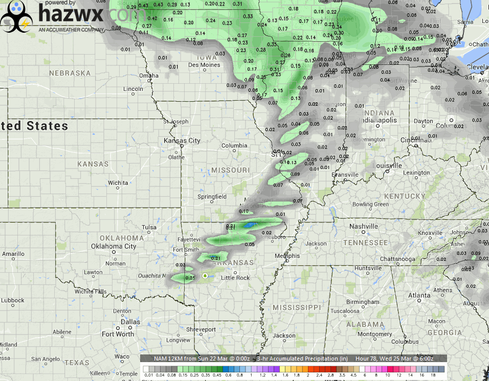
How much precipitation should we expect over the next few days?
Best chances for widespread rain will arrive on Wednesday afternoon and Wednesday night.
There is a chance for some showers and thunderstorms on Tuesday. This would likely be our far northern and northwestern counties. Right now it appears mostly out of my forecast area. But, monitor updates in case there is a slight shift southward.
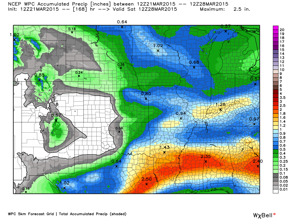
The current rainfall forecast through Thursday…from weatherbell.com

No snow through Thursday. Monitoring Friday night into Saturday morning. Maybe some light snow

This section of the blog is speculative forecast information. Because it is past the range of what meteorologists can forecast accurately, it should be considered speculation. Anything past day 5 is considered a long range forecast.
We have our first real chance for thunderstorms in the area on Wednesday. In particular Wednesday afternoon and evening.
Keep in mind that forecasts are subject to change as an event draws closer. This is especially true for winter weather and severe weather forecasts. Check back each day for the most up to date information.
First…
Late Tuesday night there could be a broken line of showers and thunderstorms approach our area from the west. It does not appear this will be widespread precipitation. But, will monitor and update if the new data over the coming days shifts my idea around a bit.
Couple of maps from hazwx.com
This is the mid-level CAPE map. CAPE is basically energy available in the atmosphere. Not all that impressive, but enough that thunder would be included in the forecast.
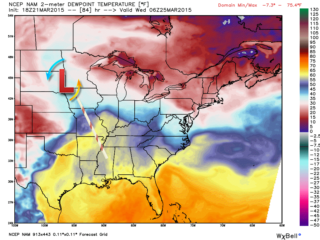
Here are the dewpoints. Remember dewpoints are what forecasters use to determine how much moisture is in the atmosphere. It is a better measure than relative humidity.
You can see a tongue of higher dewpoints stretching into central Illinois ahead of the cold front.
And here is the future-cast radar for late Tuesday night and the wee hours of Wednesday morning. Looks like a broken line of showers and possible thunderstorms. It weakens as it moves eastward. This doesn’t impress me all that much.
Looking ahead to Wednesday afternoon and evening…
The severe weather parameters appear minimal with this system, but not zero.
This could be one of those events where the best chances for an area of showers and thunderstorms will be along and just behind a cold front. Perhaps from Evansville, Indiana towards the Missouri Bootheel. The placement of the front will be key to how far west precipitation chances will occur. It does appear the best chances might end up over our southern and southeastern counties. But, monitor updates as we are still three days away from the event.
Severe weather risk?
Wind fields are not overly impressive. For widespread severe weather one looks for strong wind fields at all levels and quite a bit of shear. Instability will also be marginal. The signals for severe weather are not strong. But, with that said – some storms could be locally strong with gusty winds and small hail. Whether storms reach severe levels will need to be monitored as we move forward.
Analog forecasting does give some signals for at least a risk of a couple of severe thunderstorms in the region.
The best chance for showers and thunderstorms would be Wednesday afternoon and evening.
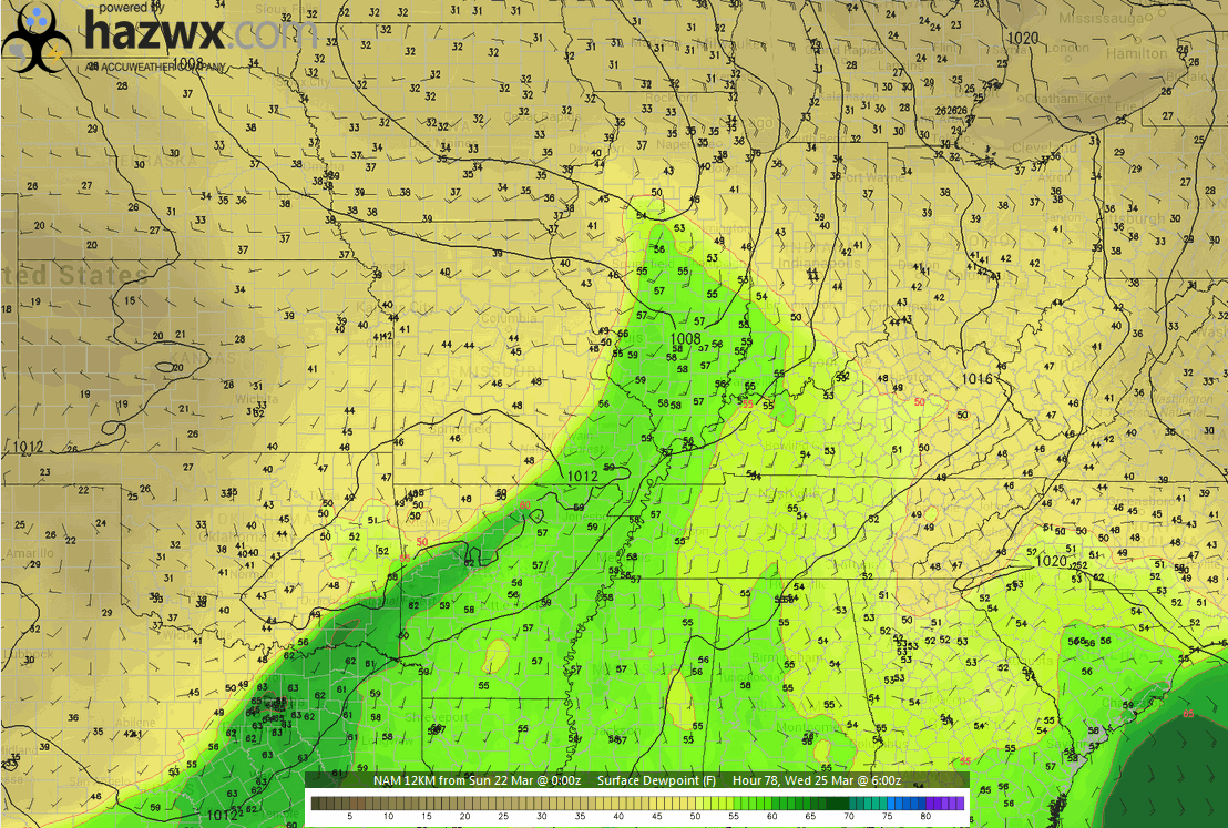
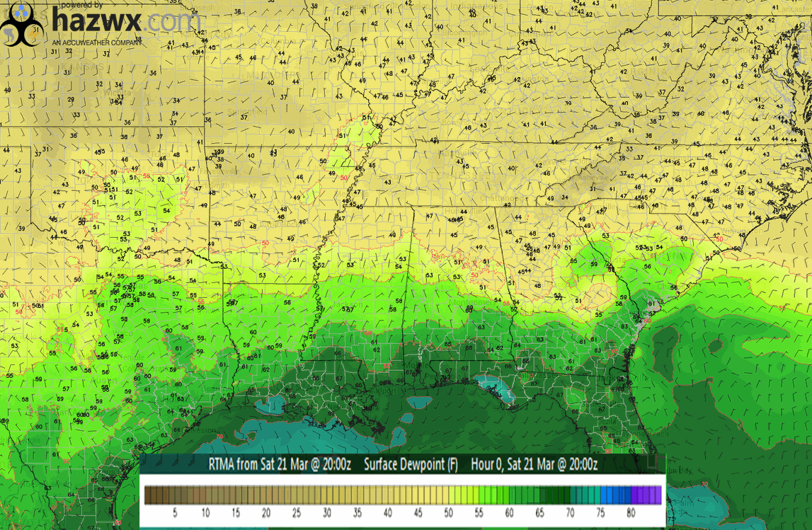
Dew points will be on the rise over the coming days. Once the winds turn out of the south…moisture will rise. Dew points are how forecasters measure moisture in the atmosphere (this is actually a better measurement than relative humidity values).
Here is the dew point map on Saturday evening (below). See the deeper moisture pulled along the Gulf of Mexico (darker green colors)?
Click image for larger view. Image is from hazwx.com
For heavy rain and strong/severe thunderstorms one looks for dew points in the upper 50’s and especially 60’s. As of Saturday evening our dew points were in the 40’s. But, dew points will be on the rise over the coming days. This map will bring the green into our local counties by Tuesday/Wednesday. I will post an updated map over the coming days. You will see how the moisture is pulled northward ahead of our area of low pressure. Low pressure rotates counter-clockwise. That means if the low passes to our west or north that the moisture is pulled northward in our region. Imagine a straw. The straw sucking the moisture northward ahead of our cold front and area of low pressure.
Here is the Tuesday night weather map – example of what I mean. You can see the area of low pressure over Minnesota. Notice how the higher dew points (moisture) is being pulled northward? This is the dew point temperature map. Higher dew points being pulled northward from the Gulf of Mexico (11 pm to 1 am on Tuesday night)
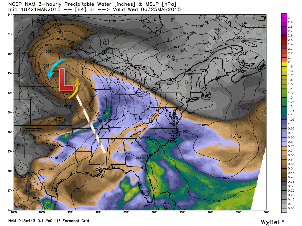
And here are the PWAT values (see below for more information on PWAT values)
Okay, well you get the idea. Low pressure to our north is going to pull moisture northward this week.
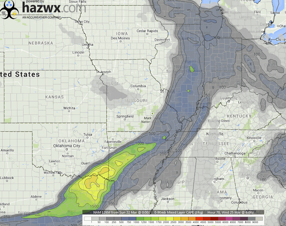
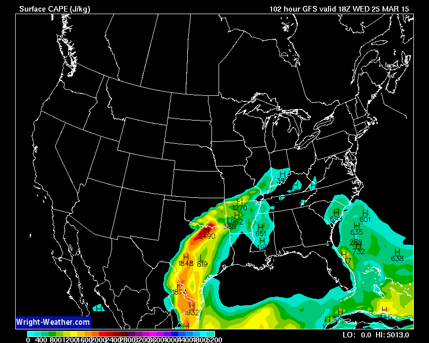
Let’s look at CAPE values on Wednesday. What the heck is CAPE? Good question 🙂 – CAPE is basically available energy in the atmosphere. More information on CAPE can be viewed here – click here
For severe weather (during late March) I look for CAPE values of 800+. This is the Wednesday 11 am to 1 pm CAPE values. You can see a tongue of higher CAPE values entering our region along and ahead of a cold front. Marginal numbers. CAPE maps are from wright-weather.com
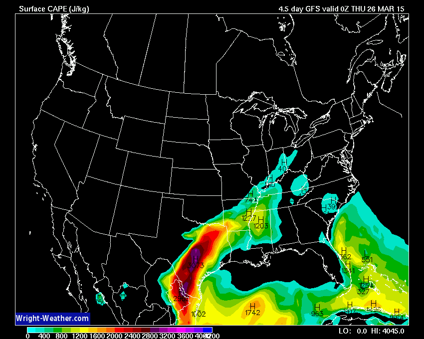
Then by Wednesday evening…these are the CAPE numbers. Very marginal numbers for severe weather. This does not appear to be a big severe weather event in our region. But, it is worth monitoring. These numbers could change. We are still several days away from the event.
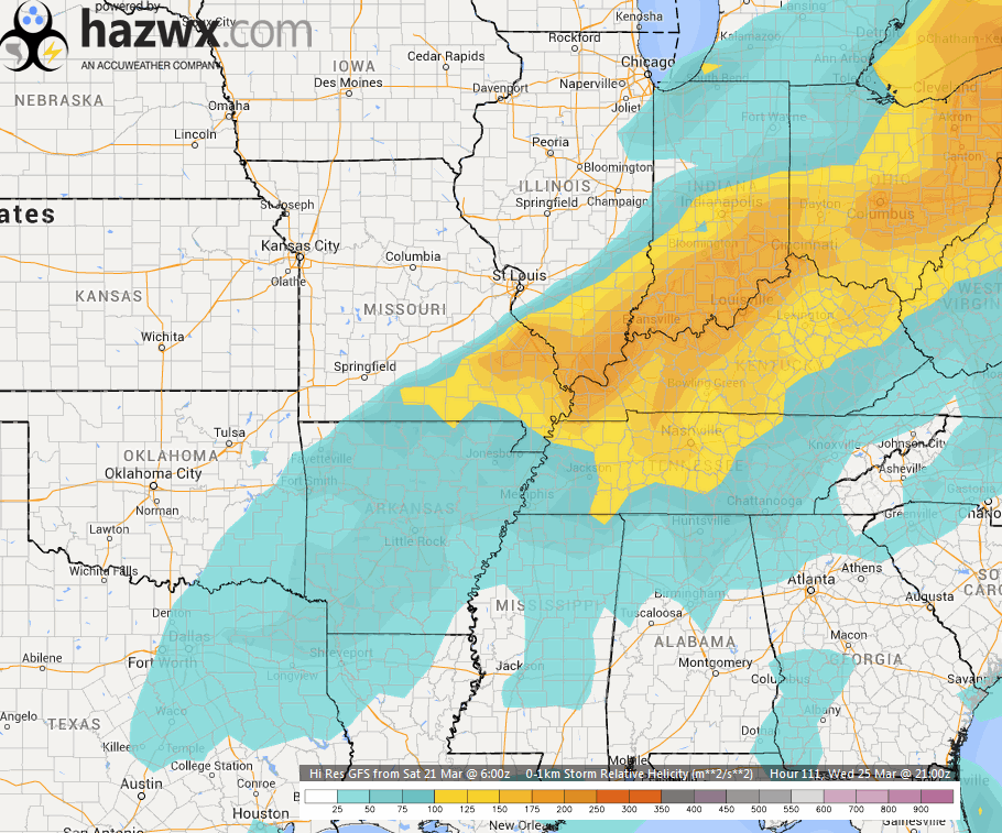
Let’s take a look at helicity. Another weird word for non-weather people. What is helicity? Click here for more information. Helicity has to do with changes of wind speed and direction with height. We do have some semi-decent helicity on Wednesday in the area. It isn’t a strong signal when combined with the other factors.
Bottom line…a few storms on Wednesday could be on the strong side and perhaps even a couple of severe thunderstorms. Main concern would probably be gusty winds and small hail. This event is still a few days away. Best advice is to keep checking back for updates. Image is from hazwx.com
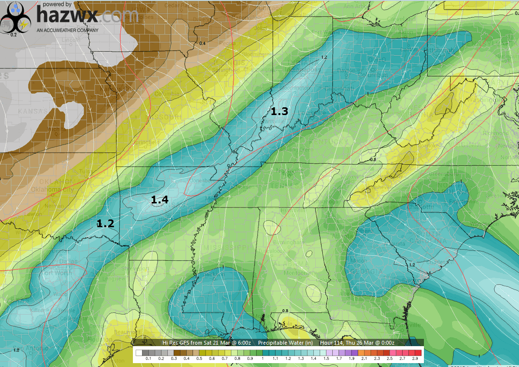
Let’s look at PWAT values. Some of you who have been with me for awhile will know what that is. PWAT is precipitable water values. How much moisture is in the entire atmospheric column. If you were to wring all the moisture out in the column how much would you have. Maps are showing 1″-1.4″. Those are decent numbers for the middle of March (not extreme). Some locally heavy downpours are possible on Wednesday afternoon and evening along and ahead of the cold front.
Image is from hazwx.com
Another item of note…
The models are spitting out heavier precipitation totals over our southern and southeastern counties on Wednesday. As a matter of fact, some of the data leaves our western and northern counties out of most of the precipitation. This will need to be monitored. It could be that the line of showers and thunderstorms forms over the southern half of the region. Let’s say from Evansville towards the Missouri Bootheel…along that line and east of that line.
This is how the GFS model depicts Wednesday evening’s thunderstorms.
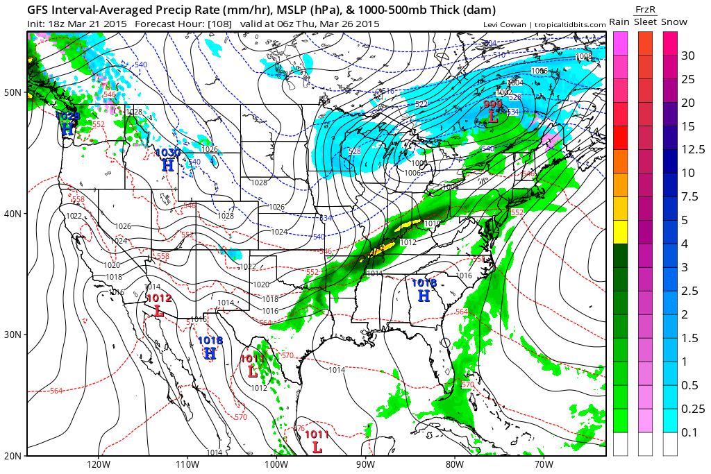
Still several days away. Watch for updates as we move forward.
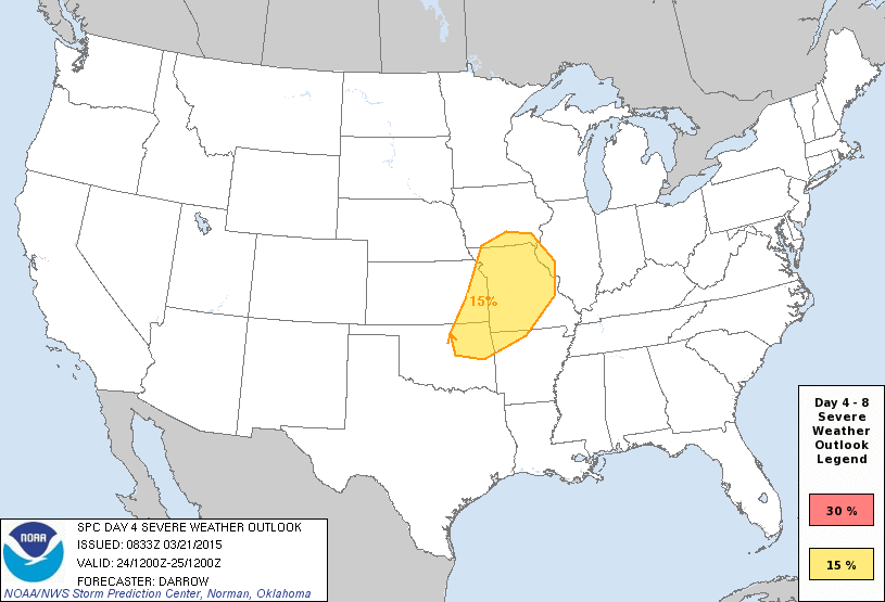
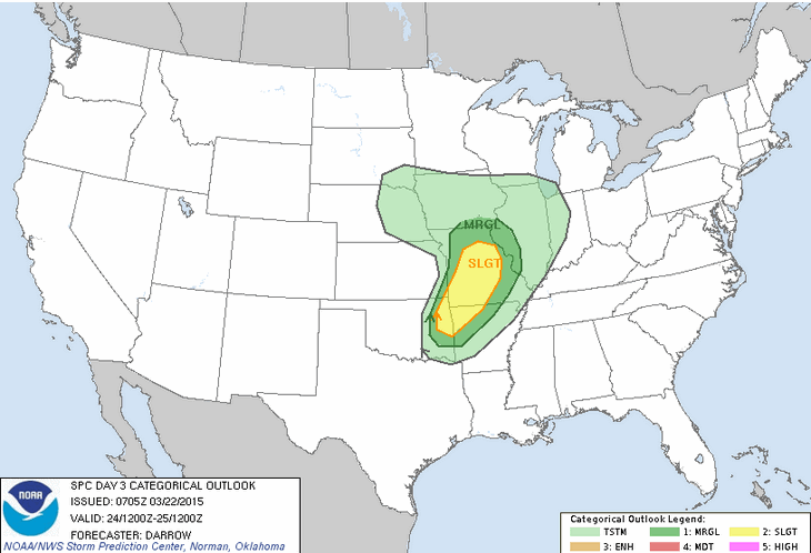
Let’s look at what the Storm Prediction Center (SPC) has to say. Who is the Storm Prediction Center? They are the ones who issue severe weather outlooks. They also issue the tornado and severe thunderstorm watches. Warnings come from our local NWS office. Watches come from the SPC.
They have a 4-8 day outlook.
At this point they have not outlined anything for Day 5 (Wednesday). That could change, so monitor updates.
Their Tuesday outlook does have a risk for a few severe thunderstorms over parts of Missouri. These outlooks are updated every day. That means there could be some shifting around of the exact placement of the risk. For now, Tuesday’s potential should be to our west.
You can see they have placed us in the light green color. That means general thunderstorms are possible (mostly Tuesday night). General thunderstorms means below severe limits. A severe thunderstorm is a storm that produces 58 mph winds, 1″ size hail or larger, and/or a tornado. The SPC has outlined the risk more to our west for Tuesday/Tuesday evening.
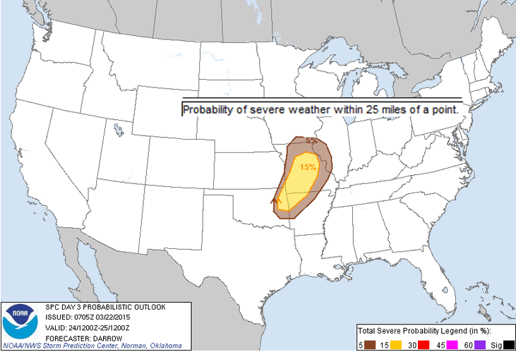
Here is the probability outlook. What are the chances for severe weather within 25 miles of any given point on Tuesday and Tuesday night?
As we move into severe weather events I will post updates on Facebook. I usually do 3-4 hour severe weather threads.
Remember, you should not rely on social media for your severe weather watches and warnings. Your warnings should come from app’s, NOAA Weather Radio, local media, or other sources for LIVE information. Do not rely on social media for warnings. Can’t emphasize this enough.
Social media is GREAT for a heads up about incoming weather events. But, once the storms hit the fan you should be utilizing other tools for information.
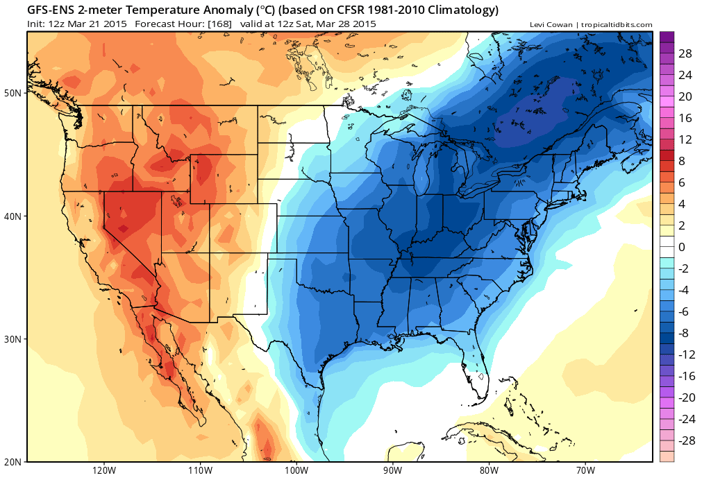
Looking ahead to next weekend. Might get chilly again on Friday into Sunday. GFS is showing well below normal temperatures.
The longer range shows some nice warm spells mixed in with colder than normal temperatures. Roller-coaster ride of temperatures.

We have regional radars and local city radars – if a radar does not seem to be updating then try another one. Occasional browsers need their cache cleared. You may also try restarting your browser. That usually fixes the problem. Occasionally we do have a radar go down. That is why I have duplicates. Thus, if one fails then try another one.
If you have any problems then please send me an email beaudodson@usawx.com
WEATHER RADAR PAGE – Click here —
We also have a new national interactive radar – you can view that radar by clicking here.
Local interactive city radars include St Louis, Mt Vernon, Evansville, Poplar Bluff, Cape Girardeau, Marion, Paducah, Hopkinsville, Memphis, Nashville, Dyersburg, and all of eastern Kentucky – these are interactive radars. Local city radars – click here
NOTE: Occasionally you will see ground clutter on the radar (these are false echoes). Normally they show up close to the radar sites – including Paducah.

Regional Radar
![]()
Current WARNINGS (a warning means take action now). Click on your county to drill down to the latest warning information. Keep in mind that there can be a 2-3 minute delay in the updated warning information.
I strongly encourage you to use a NOAA Weather Radio or warning cell phone app for the most up to date warning information. Nothing is faster than a NOAA weather radio.

Color shaded counties are under some type of watch, warning, advisory, or special weather statement. Click your county to view the latest information.

Please visit your local National Weather Service Office by clicking here. The National Weather Service Office, for our region, is located in Paducah, Kentucky. They have a lot of maps and information on their site. Local people…local forecasters who care about our region.


Here is the official 6-10 day and 8-14 day temperature and precipitation outlook. Check the date stamp at the top of each image (so you understand the time frame).
The forecast maps below are issued by the Weather Prediction Center (NOAA).


The latest 8-14 day temperature and precipitation outlook. Note the dates are at the top of the image. These maps DO NOT tell you how high or low temperatures or precipitation will be. They simply give you the probability as to whether temperatures or precipitation will be above or below normal.


Who do you trust for your weather information and who holds them accountable?
I have studied weather in our region since the late 1970’s. I have 37 years of experience in observing our regions weather patterns. My degree is in Broadcast Meteorology from Mississippi State University and an Associate of Science (AS). I am currently working on my Bachelor’s Degree in Geoscience. Just need to finish two Spanish classes!
I am a member of the American Meteorological Society. I am a NOAA Weather-Ready Nation Ambassador. And, I am the Meteorologist for McCracken County Emergency Management.
I own and operate the Southern Illinois Weather Observatory.
There is a lot of noise on the internet. A lot of weather maps are posted without explanation. Over time you should learn who to trust for your weather information.
My forecast philosophy is simple and straight forward.
- Communicate in simple terms
- To be as accurate as possible within a reasonable time frame before an event
- Interact with you on Twitter, Facebook, and the blog
- Minimize the “hype” that you might see on television or through other weather sources
- Push you towards utilizing wall-to-wall LOCAL TV coverage during severe weather events
I am a recipient of the Mark Trail Award, WPSD Six Who Make A Difference Award, Kentucky Colonel, and the Caesar J. Fiamma” Award from the American Red Cross. In 2009 I was presented with the Kentucky Office of Highway Safety Award. I was recognized by the Kentucky House of Representatives for my service to the State of Kentucky leading up to several winter storms and severe weather outbreaks.
If you click on the image below you can read the Kentucky House of Representatives Resolution.

I am also President of the Shadow Angel Foundation which serves portions of western Kentucky and southern Illinois.
Many of my graphics are from www.weatherbell.com – a great resource for weather data, model data, and more


This blog was inspired by ABC 33/40’s Alabama Weather Blog – view their blog
Current tower cam view from the Weather Observatory- Click here for all cameras.

Southern Illinois Weather Observatory

The Weather Observatory

Southern Illinois Weather Observatory
WSIL TV 3 has a number of tower cameras. Click here for their tower camera page & Illinois Road Conditions

Marion, Illinois
WPSD TV 6 has a number of tower cameras. Click here for their tower camera page & Kentucky Road Conditions & Kentucky Highway and Interstate Cameras

Downtown Paducah, Kentucky
Benton, Kentucky Tower Camera – Click here for full view

Benton, Kentucky

I24 Paducah, Kentucky

I24 Mile Point 9 – Paducah, KY

I24 – Mile Point 3 Paducah, Kentucky

You can sign up for my AWARE email by clicking here I typically send out AWARE emails before severe weather, winter storms, or other active weather situations. I do not email watches or warnings. The emails are a basic “heads up” concerning incoming weather conditions.