We have some great sponsors for the Weather Talk Blog. Please let our sponsors know that you appreciate their support for the Weather Talk Blog.
Milner and Orr Funeral Home and Cremation Services located in Paducah, Kentucky and three other western Kentucky towns – at Milner and Orr they believe in families helping families. You can find Milner and Orr on Facebook, as well.
![]()
.

Wortham Dental Care located in Paducah, Kentucky. The gentle dentist. Mercury free dentistry. They also do safe Mercury removal. You can find Wortham Dental Care on Facebook, as well
.

Trover’s Equipment and Lawn Care – Family owned and operated! They are a dealer for Snapper, Simplicity, Snapper Pro, Bad Boy Mowers, and Intimidator Utility Vehicles. They are a Stihl and Dolmar power products dealer. They also are a dealer for Briggs & Stratton, Kohler gas & diesel engines, and Kawasaki engines. They service and repair just about any brand. You can find them on Facebook, as well
.

Visit their web-site here. Or, you can also visit their Facebook page.
.

Endrizzi’s Storm Shelters – For more information click here. Endrizzi Contracting and Landscaping can be found on Facebook, as well – click here
.
Are you looking for a full service insurance agency that writes homes, businesses, and vehicles in Illinois, Kentucky, and Tennessee. Call Gary’s office at 270.442.8234 for rates and plans to protect what matters to you!

Gary Eckelkamp’s web-site click the above banner or click here
.

This forecast update covers far southern Illinois, far southeast Missouri, and far western Kentucky. See the coverage map on the right side of the blog.
Remember that weather evolves. Check back frequently for updates, especially during active weather.
The forecast numbers below may vary a bit across the region. These are the averages.
Monday night – Mostly clear and perhaps a bit on the cool side.
Temperatures: Lows in the upper 40’s to lower 50’s.
Winds: Northeast winds at 5 mph.
My confidence in this part of the forecast verifying is high
Should I cancel my outdoor plans? No
Is severe weather expected? No
What is the chance for precipitation? 0%
What impact is expected? No real impacts.
What impact is expected? None
Don’t forget to Tweet me your sunrise/sunset photos, storm photos, or other weather related photographs. I will try to retweet them or use them in the blog.
https://twitter.com/BeauDodson
Tuesday – Sunny. A little warmer. Dry.
Temperatures: Highs in the upper 70’s to around 80 degrees.
Winds: Northeast winds at 5-10 mph
My confidence in this part of the forecast verifying is medium
Should I cancel my outdoor plans? No
Is severe weather expected? No
What is the chance for precipitation? 0%
What impact is expected? No real impacts.
Tuesday night – Mostly clear and cool.
Temperatures: Lows in the upper 40’s to lower 50’s.
Winds: Northeast winds at 5 mph.
My confidence in this part of the forecast verifying is high
Should I cancel my outdoor plans? No
Is severe weather expected? No
What is the chance for precipitation? 0%
What impact is expected? No real impacts.
What impact is expected? None
Wednesday – Sunny. A little warmer. Dry.
Temperatures: Highs in the lower 80’s.
Winds: Northeast winds at 5-10 mph
My confidence in this part of the forecast verifying is high
Should I cancel my outdoor plans? No
Is severe weather expected? No
What is the chance for precipitation?
What impact is expected? No real impacts.
Wednesday night – Mostly clear and cool. Autumn like temperatures. Windows open!
Temperatures: Lows in the lower to middle 50’s.
Winds: Northeast winds at 5 mph.
My confidence in this part of the forecast verifying is high
Should I cancel my outdoor plans? No
Is severe weather expected? No
What is the chance for precipitation? 0%
What impact is expected? No real impacts.
What impact is expected? None
Thursday – Partly sunny. A little warmer. Perhaps quite a few clouds over our southeast and southern counties. Watching a disturbance to our southeast.
Temperatures: Highs in the lower to middle 80’s.
Winds: East winds at 5-10 mph
My confidence in this part of the forecast verifying is high
Should I cancel my outdoor plans? No
Is severe weather expected? No
What is the chance for precipitation?
What impact is expected? No real impacts.
Thursday night – Some clouds. Autumn like temperatures.
Temperatures: Lows in the upper 50’s.
Winds: Southeast winds at 5 mph.
My confidence in this part of the forecast verifying is high
Should I cancel my outdoor plans? No
Is severe weather expected? No
What is the chance for precipitation? 0%
What impact is expected? No real impacts.
What impact is expected? None
Friday – Partly sunny. A little warmer. Dry.
Temperatures: Highs in the middle 80’s.
Winds: South winds at 5-10 mph
My confidence in this part of the forecast verifying is high
Should I cancel my outdoor plans? No
Is severe weather expected? No
What is the chance for precipitation?
What impact is expected? No real impacts.
Friday night – A few clouds. A little milder.
Temperatures: Lows in the lower 60’s.
Winds: Southeast winds at 5 mph.
My confidence in this part of the forecast verifying is high
Should I cancel my outdoor plans? No
Is severe weather expected? No
What is the chance for precipitation? 0%
What impact is expected? No real impacts.
What impact is expected? None
Saturday – Partly sunny. A little warmer. Dry.
Temperatures: Highs in the middle 80’s.
Winds: South winds at 5-10 mph
My confidence in this part of the forecast verifying is medium
Should I cancel my outdoor plans? No
Is severe weather expected? No
What is the chance for precipitation?
What impact is expected? No real impacts.

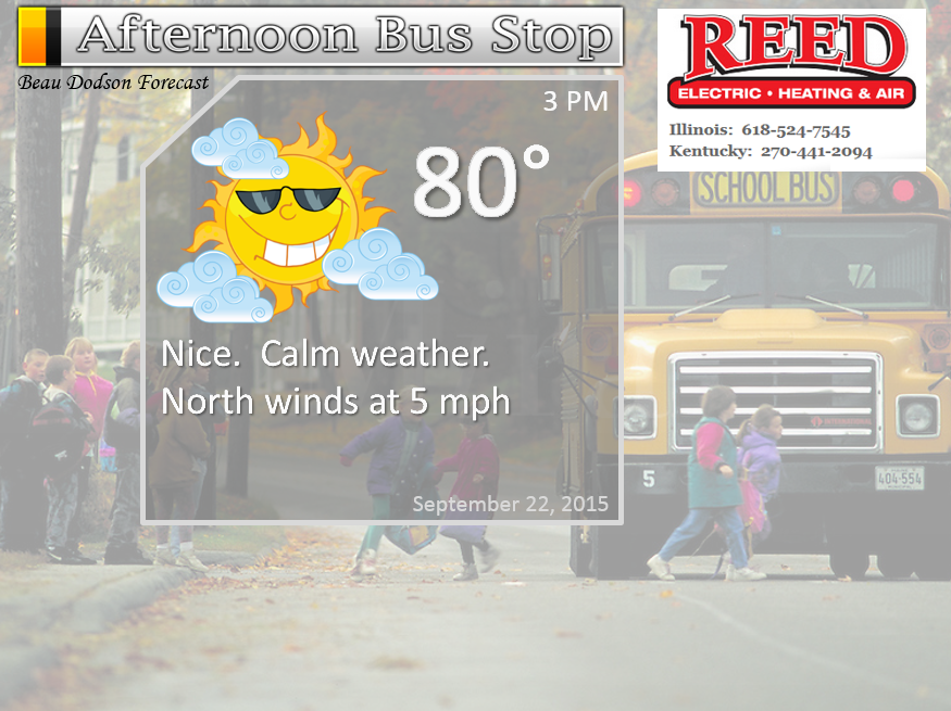
The School Bus Stop Forecast is sponsored by Reed Electric, Heating & Air in Metropolis, IL offers full electrical, heating, and air conditioning services, as well as automatic transfer generators. Our licensed and insured service technicians serve Southern Illinois and Western KY with 24 hour service. Free estimates available for all new installations!
Click their ad below to visit their web-site or click here reedelec.com


![]()

Don’t forget to check out the Southern Illinois Weather Observatory web-site for weather maps, tower cams, scanner feeds, radars, and much more! Click here

An explanation of what is happening in the atmosphere over the coming days…
Highlights
1. A warming trend with above normal temperatures returning
2. Dry weather to continue through the week and perhaps into next week
3. Tropics at the end of the month?
4. October forecast
Dry and calm weather will prevail through the rest of this week. Expect a warming trend with each passing day. Cool nights.
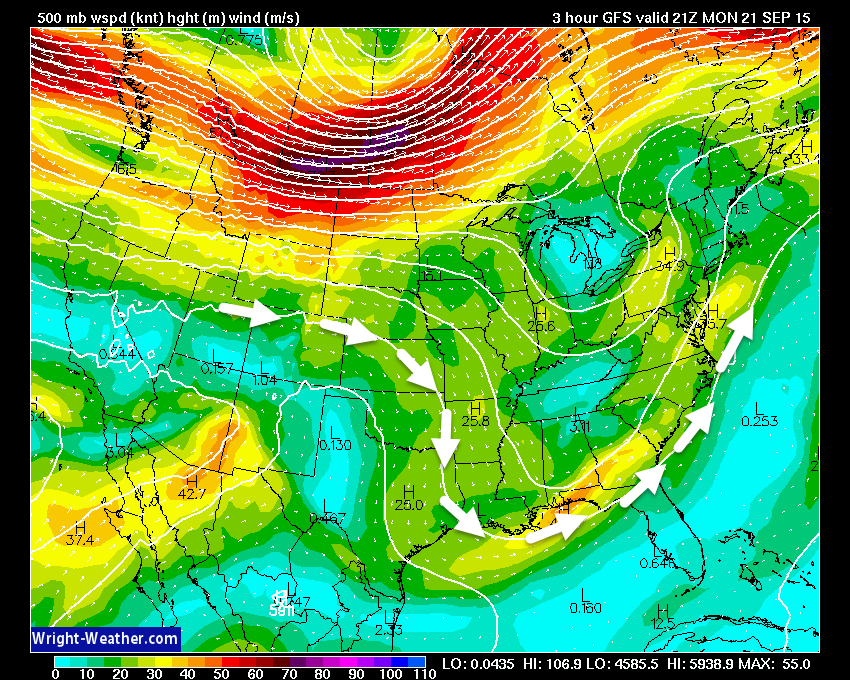
If we look at the 500 mb maps (about 18,000 feet aloft) we can see we start off with a northwest flow in the region. This is helping to keep our temperatures cool.
As we move through the week, however, the northwest flow may subside. An upper level low spinning over the southeast United States may shift westward over the coming days. This could bring some clouds into our region by Thursday and Friday. And, if the system were to push far enough northwest then we might even experience a chance for a few showers. But, for now I will keep the forecast dry and continue to watch its movement.
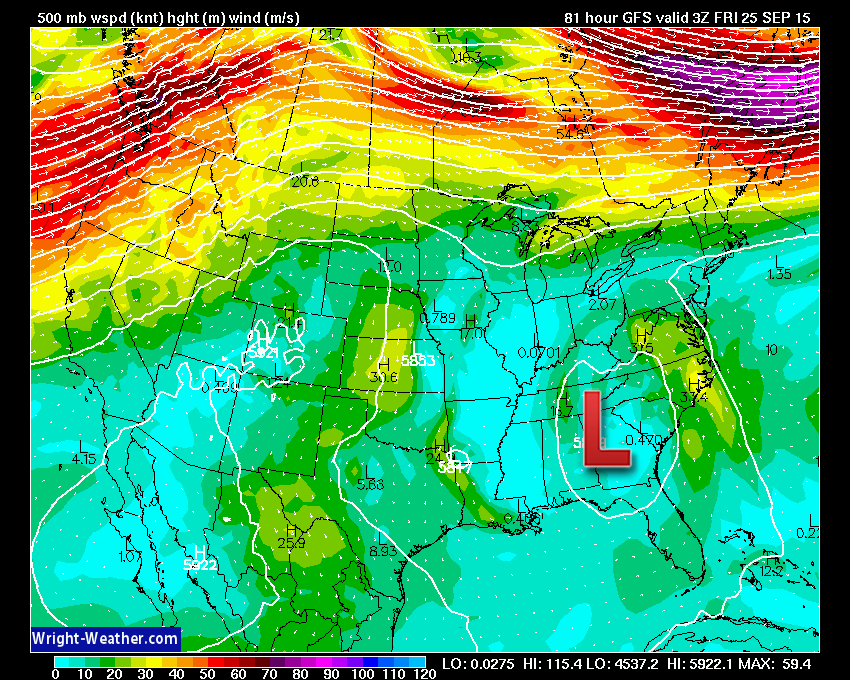
This first image shows you the 500 mb winds for Monday/Tuesday. The bright red colors are higher winds. That is the jet stream well to our north. The jet is fairly far north for this time of the year. Mostly in Canada. It will start to slide southward over the coming weeks as the seasons undergo a change. The jet stream so far north is another reason we have experienced dry weather.
The white arrows represent our wind flow. Light winds for the most part. Image is from wright-weather.com
And this second image illustrates the wind flow by Thursday and Friday. You can see the jet stream is still well well to our north. But, you can also see the upper level low to our southeast.
The dry soil conditions will help us cool during the overnight hours. It will also mean warmer temperatures during the day. That is how dry ground conditions work. Wet soil conditions typically mean cooler highs during the day and warmer nights. Dry soil conditions mean a greater range in high and low temperatures. Dry soil loses heat quite rapidly. It also warms quite rapidly.
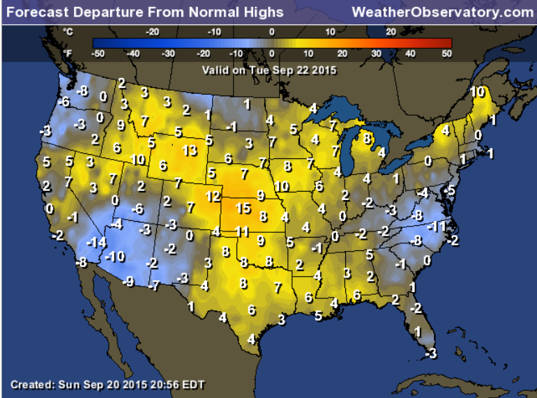
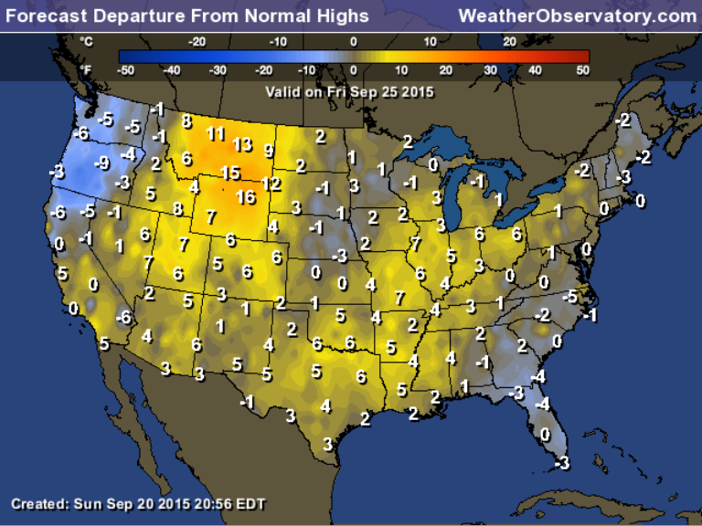
Let’s look at the temperature departure maps. Will we be below or above normal in the temperature department? Most of this week will end up with above normal high temperatures.
We start off the week with temperatures right at or slightly below normal. But, check out the second image. We end above normal as we push through the week. Normal high temperatures are around 80 degrees.
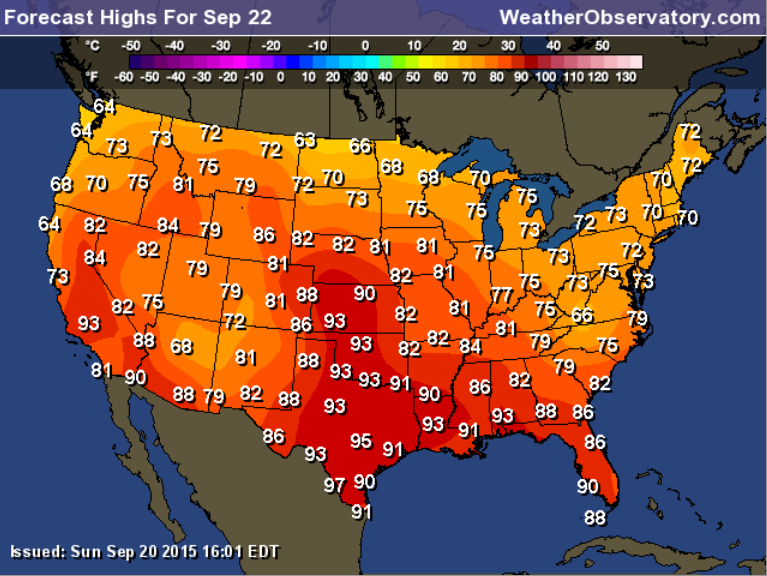
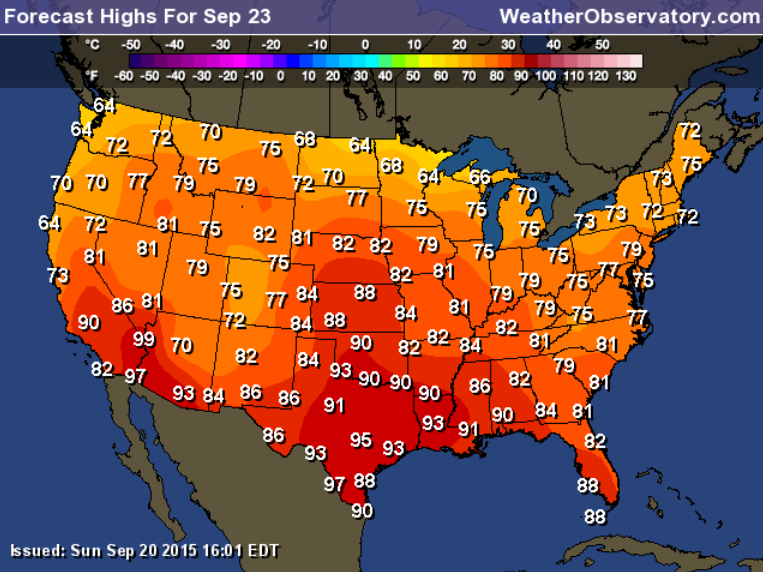
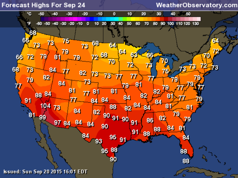
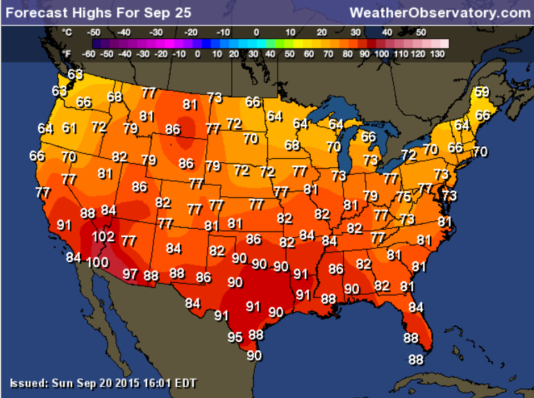
Let’s take a look at high temperature forecasts for the coming days.
This first map is for Tuesday.
This map is for Wednesday.
This map is for Thursday.
And, this map is for Friday. Above normal temperatures with highs into the 80’s.
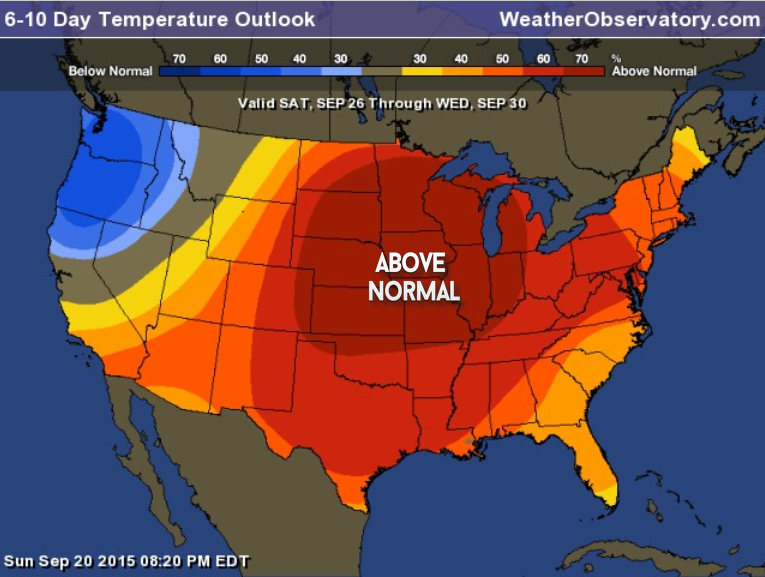
The 6-10 day temperature outlook indicates above normal temperatures for our region. Normal highs for this time of the year are around 80 degrees. Normal lows are around 55 degrees.
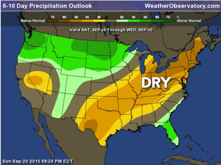
The 6-10 day precipitation outlook indicates below normal precipitation. Odds favor below normal precipitation.
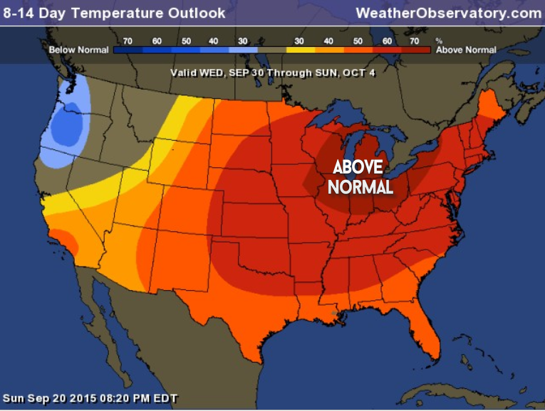
The 8-14 day temperature outlook (the map below) indicates a good chance for above normal temperatures. Warmer than normal.
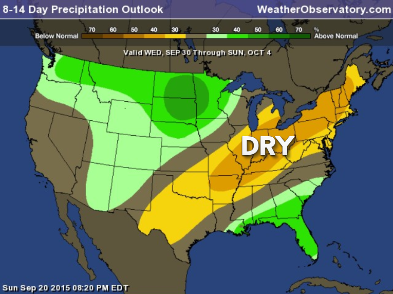
The 8-14 day precipitation outlook will take us through October 4th. It is indicating below normal precipitation.
We should watch the tropics. Long shot, but if something were to form in the Gulf of Mexico then it could move northward. Again, a long shot as to whether or not that might happen. Both the EC and GFS models do show some type of tropical system attempting to form in the Gulf of Mexico next week. I will keep an eye on it.
Right now I am leaning towards above normal temperatures in October and below normal precipitation.
I will continue to monitor the tropics. Long shot, but if something were to form in the Gulf of Mexico then it would need to be monitored. Sometimes these systems track into our region and produce rain.
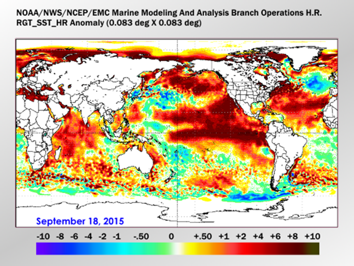
Check out this map below.
This is the anomaly map for the ocean waters. See all that red? Huge areas of above normal anomalies.
What does this mean for fall and winter? Well, that is a great question and one that many meteorologists are pondering. And, I have not seen many meteorologists that actually agree as to how this all plays out. It is a substantial El Nino. On top of that the waters right off the West Coast are warm. Typically that means cold weather for our region (during the winter months). And there are a lot of warm waters off the East Coast, as well.
Seasonal forecasts won’t be all that easy over the coming months.
Radars
WEATHER RADAR PAGE – Click here —
Don’t forget to support our sponsors!

How much precipitation should we expect over the next few days?
No measurable rain is forecast over the coming days. Dry weather to continue. Mostly dry into October.

Can we expect severe thunderstorms over the next 24 to 48 hours? Remember that a severe thunderstorm is defined as a thunderstorm that produces 58 mph winds or higher, quarter size hail or larger, and/or a tornado.
Thunderstorm threat level will be near ZERO for Monday through Thursday.
.
Monday: Severe weather is not anticipated
Tuesday: Severe weather is not anticipated
Wednesday: Severe weather is not anticipated
Thursday: Severe weather is not anticipated.
Friday: Severe weather is not anticipated.
Saturday: Severe weather is not anticipated.
Sunday: Severe weather is not anticipated.


Calm weather. Cool weather. No rain in the short term forecast.

I also set up a storm tracking page with additional links (use during active weather for quick reference)
Storm Tracking Tool Page

Here are the current river stage forecasts. You can click your state and then the dot for your location. It will bring up the full forecast and hydrograph.
Click Here For River Stage Forecasts…
Here are some current forecast hydrographs. These will be updated each day with new information.


Smithland Lock and Dam

Paducah, Kentucky Forecast Stage

Cairo, Illinois

Cape Girardeau, Missouri
Current Temperatures Around The Local Area


We have regional radars and local city radars – if a radar does not seem to be updating then try another one. Occasional browsers need their cache cleared. You may also try restarting your browser. That usually fixes the problem. Occasionally we do have a radar go down. That is why I have duplicates. Thus, if one fails then try another one.
If you have any problems then please send me an email beaudodson@usawx.com
WEATHER RADAR PAGE – Click here —
We also have a new national interactive radar – you can view that radar by clicking here.
Local interactive city radars include St Louis, Mt Vernon, Evansville, Poplar Bluff, Cape Girardeau, Marion, Paducah, Hopkinsville, Memphis, Nashville, Dyersburg, and all of eastern Kentucky – these are interactive radars. Local city radars – click here
NOTE: Occasionally you will see ground clutter on the radar (these are false echoes). Normally they show up close to the radar sites – including Paducah.

Regional Radar – Click on radar to take you our full radar page.


Regional Radar

Live Lightning Data – zoom and pan: Click here
Live Lightning Data with sound (click the sound button on the left side of the page): Click here
I also set up a storm tracking page with additional links (use during active weather for quick reference)
Storm Tracking Tool Page
![]()
Current WARNINGS (a warning means take action now). Click on your county to drill down to the latest warning information. Keep in mind that there can be a 2-3 minute delay in the updated warning information.
I strongly encourage you to use a NOAA Weather Radio or warning cell phone app for the most up to date warning information. Nothing is faster than a NOAA weather radio.


Color shaded counties are under some type of watch, warning, advisory, or special weather statement. Click your county to view the latest information.

Missouri Warnings

Illinois Warnings

Kentucky Warnings

Here is the official 6-10 day and 8-14 day temperature and precipitation outlook. Check the date stamp at the top of each image (so you understand the time frame).
The forecast maps below are issued by the Weather Prediction Center (NOAA).


The latest 8-14 day temperature and precipitation outlook. Note the dates are at the top of the image. These maps DO NOT tell you how high or low temperatures or precipitation will be. They simply give you the probability as to whether temperatures or precipitation will be above or below normal.


Who do you trust for your weather information and who holds them accountable?
I have studied weather in our region since the late 1970’s. I have 37 years of experience in observing our regions weather patterns. My degree is in Broadcast Meteorology from Mississippi State University and an Associate of Science (AS). I am currently working on my Bachelor’s Degree in Geoscience. Just need to finish two Spanish classes!
I am a member of the American Meteorological Society. I am a NOAA Weather-Ready Nation Ambassador. And, I am the former Meteorologist for McCracken County Emergency Management. I served them proudly for ten years before expanding my job role to additional counties in western Kentucky.
I own and operate the Southern Illinois Weather Observatory.
There is a lot of noise on the internet. A lot of weather maps are posted without explanation. Over time you should learn who to trust for your weather information.
My forecast philosophy is simple and straight forward.
- Communicate in simple terms
- To be as accurate as possible within a reasonable time frame before an event
- Interact with you on Twitter, Facebook, and the blog
- Minimize the “hype” that you might see on television or through other weather sources
- Push you towards utilizing wall-to-wall LOCAL TV coverage during severe weather events
I am a recipient of the Mark Trail Award, WPSD Six Who Make A Difference Award, Kentucky Colonel, and the Caesar J. Fiamma” Award from the American Red Cross. In 2009 I was presented with the Kentucky Office of Highway Safety Award. I was recognized by the Kentucky House of Representatives for my service to the State of Kentucky leading up to several winter storms and severe weather outbreaks.
If you click on the image below you can read the Kentucky House of Representatives Resolution.

I am also President of the Shadow Angel Foundation which serves portions of western Kentucky and southern Illinois.
Many of my graphics are from www.weatherbell.com – a great resource for weather data, model data, and more


You can sign up for my AWARE email by clicking here I typically send out AWARE emails before severe weather, winter storms, or other active weather situations. I do not email watches or warnings. The emails are a basic “heads up” concerning incoming weather conditions.