We have some great sponsors for the Weather Talk Blog. Please let our sponsors know that you appreciate their support for the Weather Talk Blog.
Milner and Orr Funeral Home and Cremation Services located in Paducah, Kentucky and three other western Kentucky towns – at Milner and Orr they believe in families helping families. You can find Milner and Orr on Facebook, as well.
![]()
.

Wortham Dental Care located in Paducah, Kentucky. The gentle dentist. Mercury free dentistry. They also do safe Mercury removal. You can find Wortham Dental Care on Facebook, as well
.

Trover’s Equipment and Lawn Care – Family owned and operated! They are a dealer for Snapper, Simplicity, Snapper Pro, Bad Boy Mowers, and Intimidator Utility Vehicles. They are a Stihl and Dolmar power products dealer. They also are a dealer for Briggs & Stratton, Kohler gas & diesel engines, and Kawasaki engines. They service and repair just about any brand. You can find them on Facebook, as well
.

Visit their web-site here. Or, you can also visit their Facebook page.
.

Endrizzi’s Storm Shelters – For more information click here. Endrizzi Contracting and Landscaping can be found on Facebook, as well – click here
.
Are you looking for a full service insurance agency that writes homes, businesses, and vehicles in Illinois, Kentucky, and Tennessee. Call Gary’s office at 270.442.8234 for rates and plans to protect what matters to you!

Gary Eckelkamp’s web-site click the above banner or click here
.

This forecast update covers far southern Illinois, far southeast Missouri, and far western Kentucky. See the coverage map on the right side of the blog.
Remember that weather evolves. Check back frequently for updates, especially during active weather.
The forecast numbers below may vary a bit across the region. These are the averages.
Thursday night – Mostly clear. Some clouds possible over eastern counties. Autumn weather. Cool. Small shower chances eastern counties.
Temperatures: Lows in the middle to upper 40’s
Winds: North/northeast winds at 5-10 mph.
My confidence in this part of the forecast verifying is high
Should I cancel my outdoor plans? No
Is severe weather expected? No
What is the chance for precipitation? 20%-30%
What impact is expected? No real impacts.
Friday – Partly sunny. Perhaps cloudy over our eastern counties. A few showers possible over western Kentucky. Cool.
Temperatures: Highs in the upper 60’s
Winds: North and northeast winds at 5-15 mph.
My confidence in this part of the forecast verifying is high
Should I cancel my outdoor plans? No, but a shower possible
Is severe weather expected? No
What is the chance for precipitation? 30%
What impact is expected? No real impacts.
Friday night – Some clouds. Cool. Some showers possible over western Kentucky. Small chance over southeast Illinois, as well.
Temperatures: Lows in the upper 40’s
Winds: North/northeast winds at 5-10 mph.
My confidence in this part of the forecast verifying is medium
Should I cancel my outdoor plans? No, but a shower possible
Is severe weather expected? No
What is the chance for precipitation? 20%-30%
What impact is expected? No real impacts.
Saturday – Partly sunny. Cool. A few showers possible over western Kentucky.
Temperatures: Highs in the middle to upper 60’s
Winds: North winds at 5-15 mph
My confidence in this part of the forecast verifying is medium
Should I cancel my outdoor plans? No
Is severe weather expected? No
What is the chance for precipitation? 20%-30%
What impact is expected? No real impacts.
Saturday night – Mostly cloudy. Cool. A few showers possible.
Temperatures: Lows in the upper 40’s to lower 50’s
Winds: North/northeast winds at 5-10 mph.
My confidence in this part of the forecast verifying is high
Should I cancel my outdoor plans? No
Is severe weather expected? No
What is the chance for precipitation? 20%-30%
What impact is expected? No real impacts.
Sunday – Some clouds. Cool.
Temperatures: Highs in the upper 60’s
Winds: North/northeast winds at 5-10 mph with gusts to 15 mph
My confidence in this part of the forecast verifying is medium
Should I cancel my outdoor plans? No
Is severe weather expected? No
What is the chance for precipitation? 20%
What impact is expected? No real impacts.
Sunday night – Some clouds possible. Cool.
Temperatures: Lows in the lower 50’s
Winds: Northeast winds at 5-10 mph.
My confidence in this part of the forecast verifying is medium
Should I cancel my outdoor plans? No
Is severe weather expected? No
What is the chance for precipitation? 0%
What impact is expected? No real impacts.
Monday – Partly sunny. Cool.
Temperatures: Highs in the upper 60’s to lower 70’s.
Winds: North/northeast winds at 5-10 mph
My confidence in this part of the forecast verifying is medium
Should I cancel my outdoor plans? No
Is severe weather expected? No
What is the chance for precipitation? 0%
What impact is expected? No real impacts.
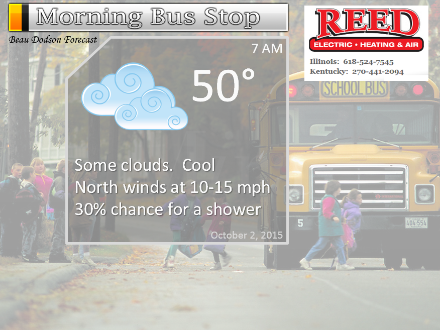
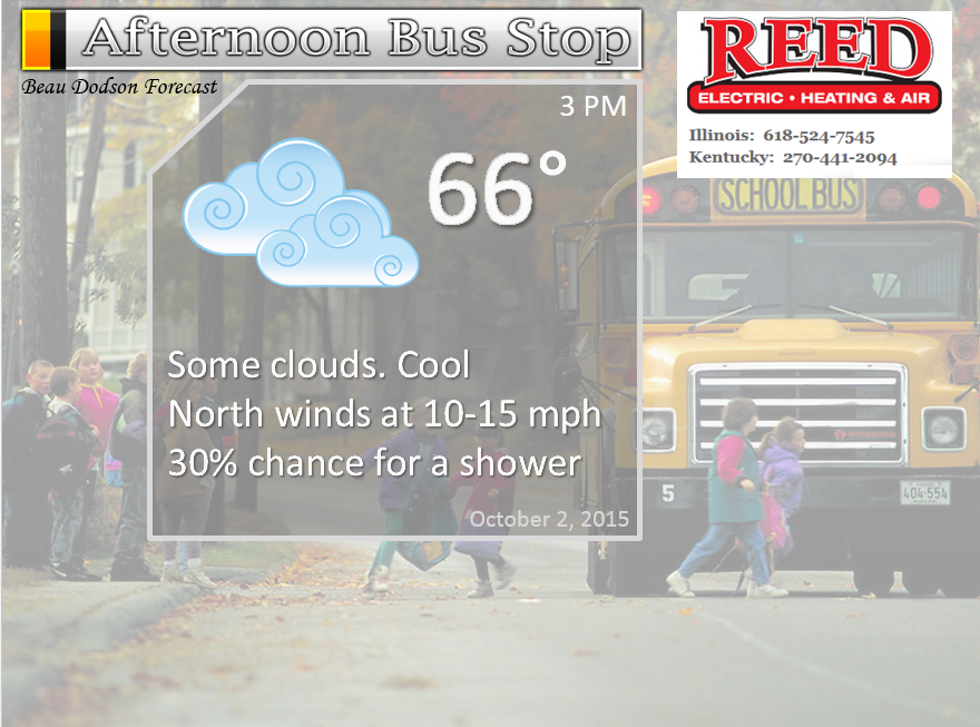
The School Bus Stop Forecast is sponsored by Reed Electric, Heating & Air in Metropolis, IL offers full electrical, heating, and air conditioning services, as well as automatic transfer generators. Our licensed and insured service technicians serve Southern Illinois and Western KY with 24 hour service. Free estimates available for all new installations!
Click their ad below to visit their web-site or click here reedelec.com


Don’t forget to check out the Southern Illinois Weather Observatory web-site for weather maps, tower cams, scanner feeds, radars, and much more! Click here

An explanation of what is happening in the atmosphere over the coming days…
Highlights
1. Cool days and nights ahead
2. Gusty winds with some clouds
3. Some showers possible (mainly our eastern counties)
4. Track an East Coast hurricane
You will notice that I have brought back some of the fall and winter graphics (below). That includes the frost forecast.
We have a couple of weather systems impacting our local region. One is an upper level low to our east/southeast. This low will help keep clouds in the region and a few showers as we move through the next 24-48 hours. Expect clouds and rain showers to push eastward on Saturday and Saturday night. This will leave just small precipitation chances over our far eastern counties on Saturday.
We will also have some 10-15 mph winds over the next day or two. Some gusts to 20 mph possible. Mostly from the north/northeast.
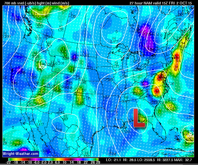
You can see that area of low pressure here on this map. Well to our southeast. Images are from wright-weather.com
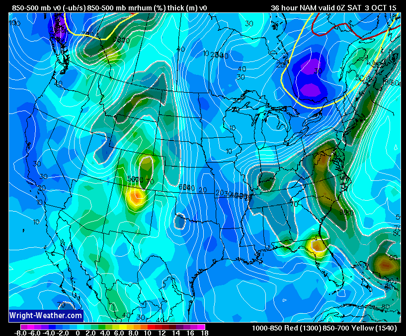
This second map is relative humidity and lift. The shaded region over our area represents some clouds and even a few showers.
Much of southeast Missouri and southern Illinois will likely miss the best shower chances over the next 48 hours. But, portions of far southern Illinois and southeast Illinois may pick up a couple of showers from time to time. Better chances for precipitation will exist over western Kentucky. Small chances over northwest Tennessee. Rainfall totals, for the most part, will be light. I suppose our far far eastern and southeastern counties from Central City towards Hopkinsville could pick up 0.20″-0.40″ of rainfall. Lesser totals west of there.
Let’s look at the future-cast radar from weatherbell.com This is the NAM model guidance. You can see some spotty showers in our region. The colors represent showers.
This first image is for Friday around 12 pm to 1 pm
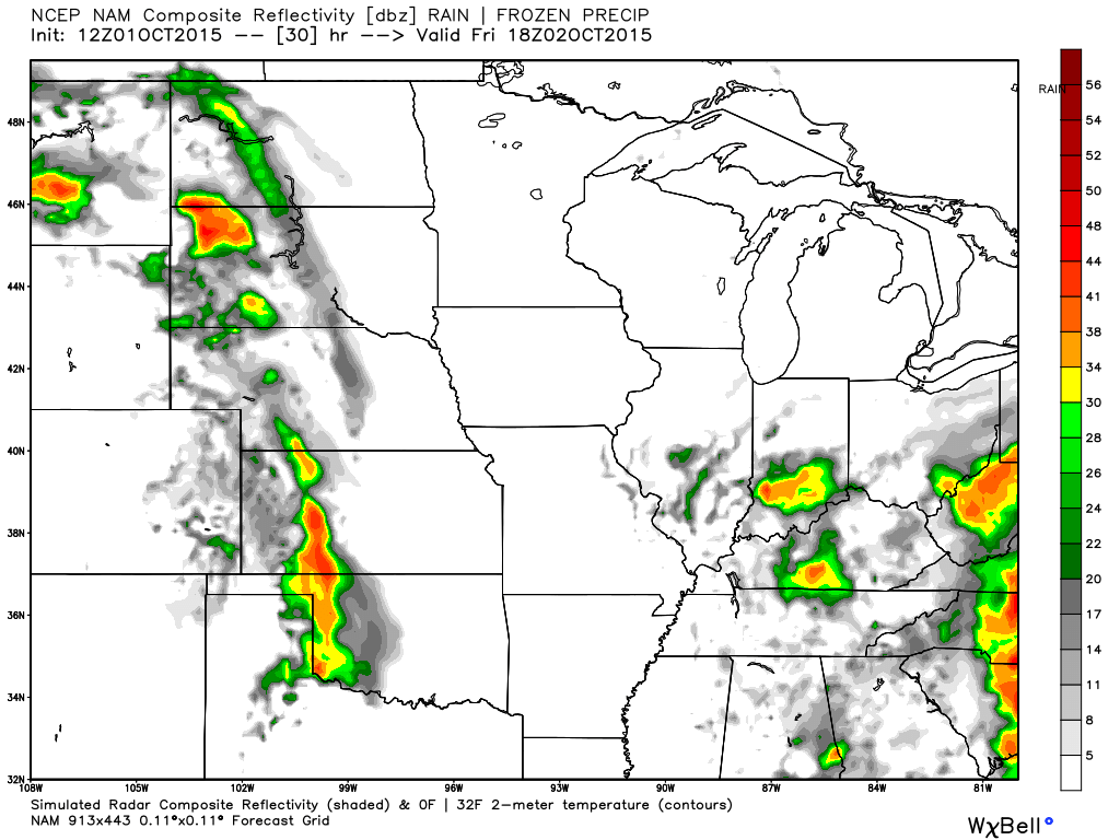
This next image is for Friday evening. The bottom line is that we could have some showers in the region over the next 24-48 hours.

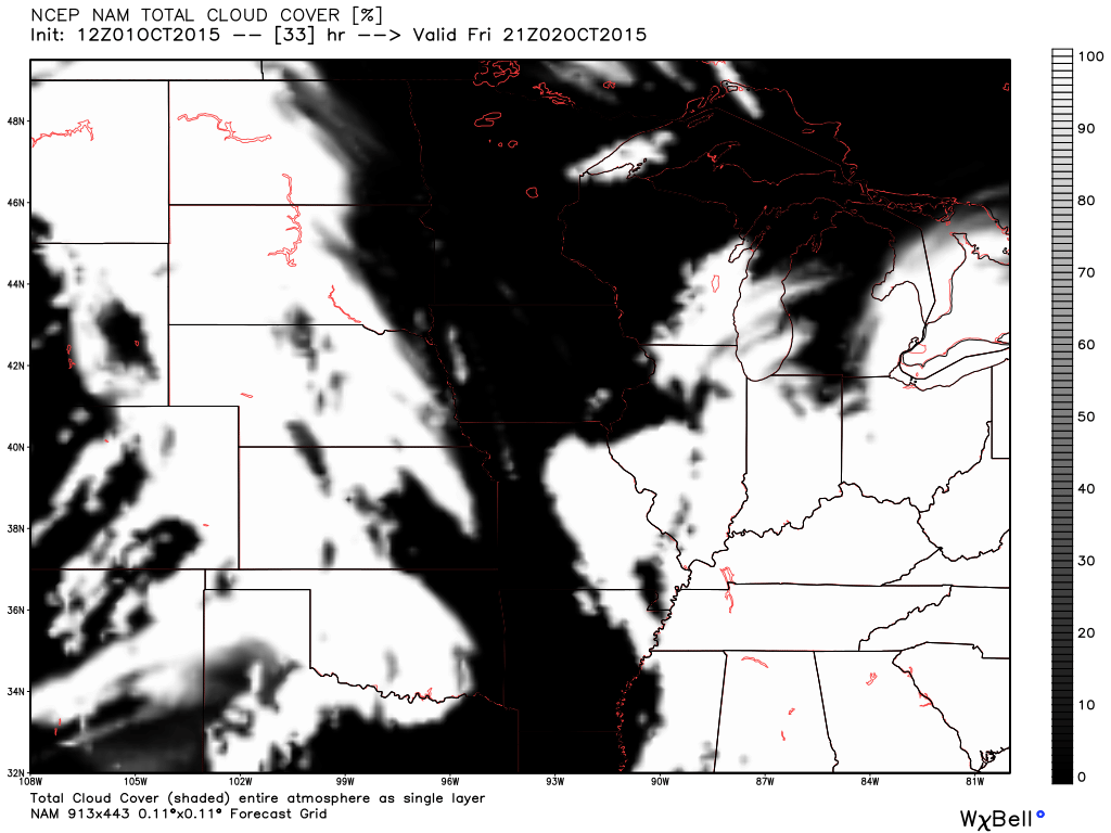
Here is the future-cast satellite photograph for Friday. White would be clouds. Expect a lot of clouds in the region.
If the upper level low is slightly further east/southeast than anticipated then rain chances will be less. Keep that in mind.
Otherwise, our weather will be dominated by cool temperatures. Highs will remain mostly in the 60’s with lows mostly in the 40’s through Sunday. A few 70-72 degrees will also be possible. Expect temperatures to slowly rise into the lower 70’s by Monday and Tuesday.
The next weather system to monitor will likely push into our region next Wednesday/Thursday. A cold front and area of low pressure is forecast to move into the central United States from the west. Still a bit early to pin down details on the extent of rain or storms with that system.
The tropics:
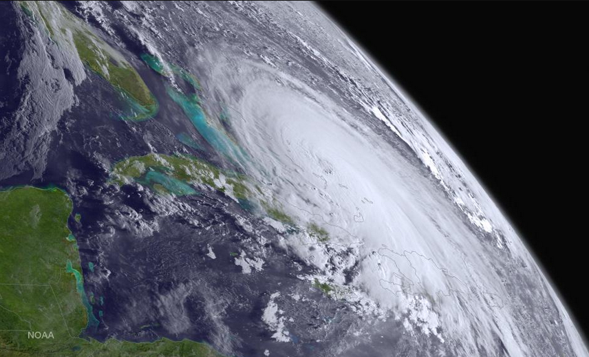
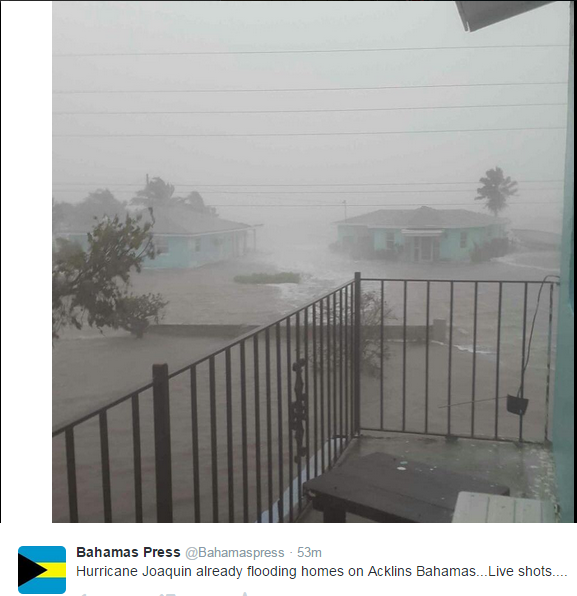
I am tracking Hurricane Joaquin.
If you remember from last nights post…I was thinking this hurricane would strengthen to a category 3 or 4. It did just that. Powerful hurricane. It has been pounding the Bahamas over the past 12-18 hours. There will be a lot of damage to some of the islands, unfortunately.
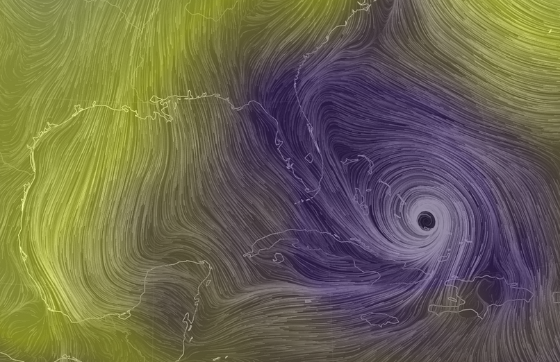
The next big question will be the eventual track of Joaquin. There are a lot of models that take this hurricane into the United States. However, the EC model is taking it out to sea. The EC model has been right with its track forecast, thus far. It is possible that the EC will be correct in taking this system out to sea. Hopefully.
I do believe this system goes out to sea.
If you have travel plans to the East Coast then keep in mind that very heavy rain is forecast even without this tropical system striking the coast. There is a trough of low pressure and a cold front along the East Coast. This is causing very heavy rain. Some places will pick up more than a foot of rain over the coming days. Be sure and check the latest local forecast for wherever you are traveling. And, pay attention to the eventual track path of the hurricane.
You can view the latest hurricane track maps and public discussion from the National Hurricane Center by clicking on this link – click here
I grabbed this image off of Twitter earlier today. This is from Acklins Bahamas

Added some showers to the forecast (increased % a bit). This is especially true for portions of western Kentucky. The further east and southeast you travel the better the chance for a shower.

No major concerns. Gusty winds at times.

No

The wild card in this forecast will be just how far west the showers will push Thursday night into Saturday morning. It seems a good bet that parts of western Kentucky will experience a few showers. Perhaps as far west as Paducah. If that were to happen then perhaps parts of far southeast Illinois, as well
Better shower chances as you travel east and southeast in the region. This as a system pushes in from the east. A bit unusual, but not unheard of.

Currently no frost in the local forecast. Still a little early for frost.
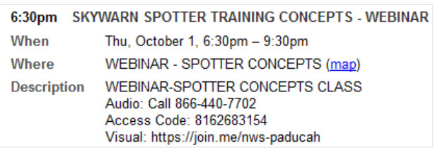
We need more at home storm spotters. If you would be interested in becoming a storm spotter (and you can spot from home, we don’t need people out and about to spot) then check out this Storm Spotter Training Webinar on Thursday, October 1st. 6:30 PM to 9:30 PM. The National Weather Service Office out of Paducah, Kentucky will be conducting the training.
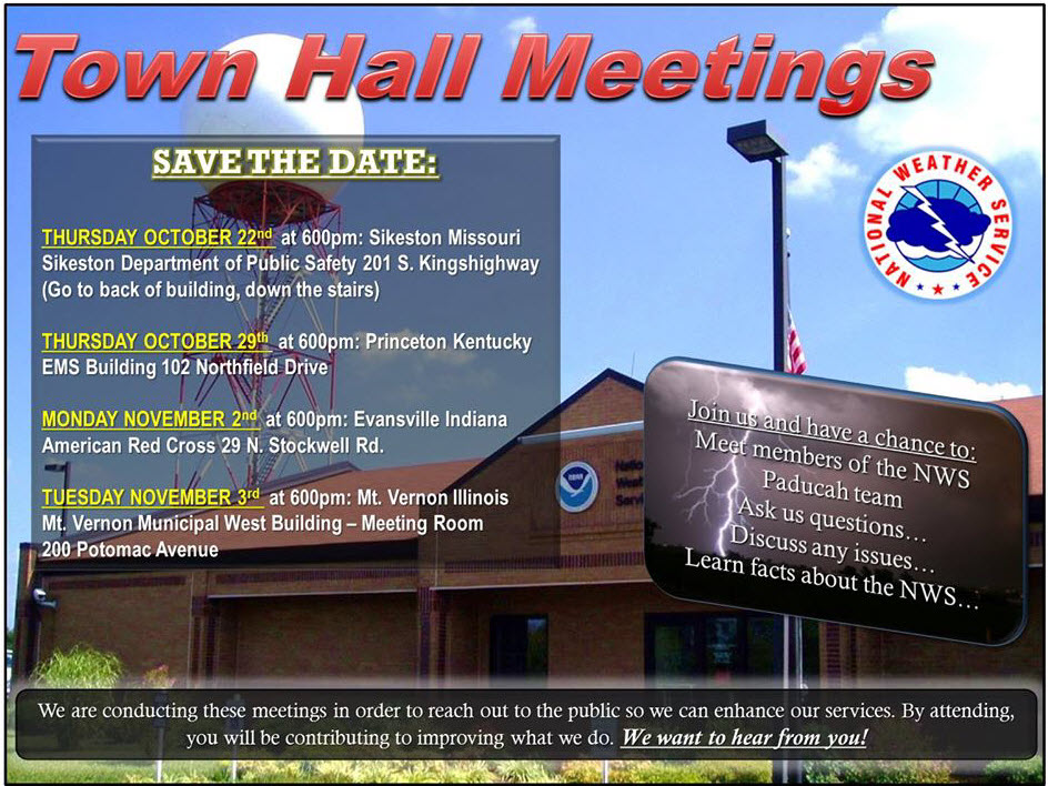
And, for the first time the NWS will be conducting town hall meetings. If you would be interested in attending a town hall meeting then here is the schedule. Click image for a larger view.
Radars
WEATHER RADAR PAGE – Click here —
Don’t forget to support our sponsors!

How much precipitation should we expect over the next few days?
Some showers are possible into Saturday morning. Mainly our eastern counties. That would include the Pennyrile of western Kentucky. Smaller chances as you travel west in the region. Rainfall totals in the 0.20″-0.40″ range are possible. Again, the bulk being over our eastern counties. Some data indicates our far eastern counties could pick up more than 0.40″. Let’s see how things trend. Far eastern counties would include Central City towards Hopkinsville, Kentucky.
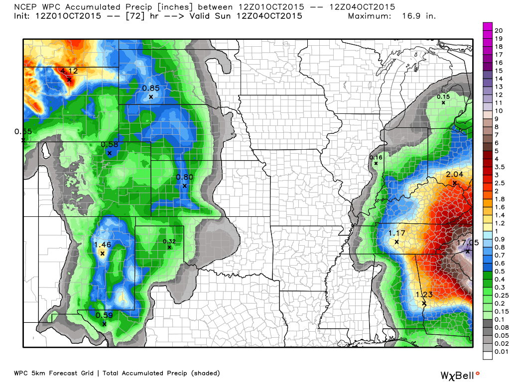
Here is the official rainfall forecast map for the next two days.
Image is from weatherbell.com I will try to update this graphic from time to time over the next 24 hours. Notice how much of a gradient there is with the rainfall totals. Any shift east or west would change the numbers in our western Kentucky counties. Perhaps parts of southern Illinois, as well. Better chances for rain east vs west.

Can we expect severe thunderstorms over the next 24 to 48 hours? Remember that a severe thunderstorm is defined as a thunderstorm that produces 58 mph winds or higher, quarter size hail or larger, and/or a tornado.
Thunderstorm threat level will be near ZERO for Friday into Monday.
.
Friday: Severe weather is not anticipated.
Saturday: Severe weather is not anticipated.
Sunday: Severe weather is not anticipated.
Monday: Severe weather is not anticipated.
Tuesday: Severe weather is not anticipated.
Wednesday: Severe weather is not anticipated.
Thursday: Watching a new cold front. Long way off for details.


I also set up a storm tracking page with additional links (use during active weather for quick reference)
Storm Tracking Tool Page

Here are the current river stage forecasts. You can click your state and then the dot for your location. It will bring up the full forecast and hydrograph.
Click Here For River Stage Forecasts…
Here are some current forecast hydrographs. These will be updated each day with new information.


Smithland Lock and Dam

Paducah, Kentucky Forecast Stage

Cairo, Illinois

Cape Girardeau, Missouri
Current Temperatures Around The Local Area


We have regional radars and local city radars – if a radar does not seem to be updating then try another one. Occasional browsers need their cache cleared. You may also try restarting your browser. That usually fixes the problem. Occasionally we do have a radar go down. That is why I have duplicates. Thus, if one fails then try another one.
If you have any problems then please send me an email beaudodson@usawx.com
WEATHER RADAR PAGE – Click here —
We also have a new national interactive radar – you can view that radar by clicking here.
Local interactive city radars include St Louis, Mt Vernon, Evansville, Poplar Bluff, Cape Girardeau, Marion, Paducah, Hopkinsville, Memphis, Nashville, Dyersburg, and all of eastern Kentucky – these are interactive radars. Local city radars – click here
NOTE: Occasionally you will see ground clutter on the radar (these are false echoes). Normally they show up close to the radar sites – including Paducah.

Regional Radar – Click on radar to take you our full radar page.


Regional Radar

Live Lightning Data – zoom and pan: Click here
Live Lightning Data with sound (click the sound button on the left side of the page): Click here
I also set up a storm tracking page with additional links (use during active weather for quick reference)
Storm Tracking Tool Page
![]()
Current WARNINGS (a warning means take action now). Click on your county to drill down to the latest warning information. Keep in mind that there can be a 2-3 minute delay in the updated warning information.
I strongly encourage you to use a NOAA Weather Radio or warning cell phone app for the most up to date warning information. Nothing is faster than a NOAA weather radio.


Color shaded counties are under some type of watch, warning, advisory, or special weather statement. Click your county to view the latest information.

Missouri Warnings

Illinois Warnings

Kentucky Warnings

Here is the official 6-10 day and 8-14 day temperature and precipitation outlook. Check the date stamp at the top of each image (so you understand the time frame).
The forecast maps below are issued by the Weather Prediction Center (NOAA).


The latest 8-14 day temperature and precipitation outlook. Note the dates are at the top of the image. These maps DO NOT tell you how high or low temperatures or precipitation will be. They simply give you the probability as to whether temperatures or precipitation will be above or below normal.


Who do you trust for your weather information and who holds them accountable?
I have studied weather in our region since the late 1970’s. I have 37 years of experience in observing our regions weather patterns. My degree is in Broadcast Meteorology from Mississippi State University and an Associate of Science (AS). I am currently working on my Bachelor’s Degree in Geoscience.
My resume includes:
Member of the American Meteorological Society.
NOAA Weather-Ready Nation Ambassador.
Meteorologist for McCracken County Emergency Management.
I own and operate the Southern Illinois Weather Observatory.
Recipient of the Mark Trail Award, WPSD Six Who Make A Difference Award, Kentucky Colonel, and the Caesar J. Fiamma” Award from the American Red Cross.
In 2009 I was presented with the Kentucky Office of Highway Safety Award.
Recognized by the Kentucky House of Representatives for my service to the State of Kentucky leading up to several winter storms and severe weather outbreaks.
I am also President of the Shadow Angel Foundation which serves portions of western Kentucky and southern Illinois.
There is a lot of noise on the internet. A lot of weather maps are posted without explanation. Over time you should learn who to trust for your weather information.
My forecast philosophy is simple and straight forward.
- Communicate in simple terms
- To be as accurate as possible within a reasonable time frame before an event
- Interact with you on Twitter, Facebook, and the blog
- Minimize the “hype” that you might see on television or through other weather sources
- Push you towards utilizing wall-to-wall LOCAL TV coverage during severe weather events
I am a recipient of the Mark Trail Award, WPSD Six Who Make A Difference Award, Kentucky Colonel, and the Caesar J. Fiamma” Award from the American Red Cross. In 2009 I was presented with the Kentucky Office of Highway Safety Award. I was recognized by the Kentucky House of Representatives for my service to the State of Kentucky leading up to several winter storms and severe weather outbreaks.
If you click on the image below you can read the Kentucky House of Representatives Resolution.

Many of my graphics are from www.weatherbell.com – a great resource for weather data, model data, and more


You can sign up for my AWARE email by clicking here I typically send out AWARE emails before severe weather, winter storms, or other active weather situations. I do not email watches or warnings. The emails are a basic “heads up” concerning incoming weather conditions.