

This forecast update covers far southern Illinois, far southeast Missouri, and far western Kentucky. See the coverage map on the right side of the blog.
If you find value in this page and the other weather products on the Weather Observatory web-site then consider making a donation to keep everything up and running. It does cost quite a bit of money each month to run the radars, data feeds, hosting of sites, and more. You can give by visiting our donation page.
Wednesday – Becoming mostly cloudy. A chance for rain showers or rain and snow mix – mainly this afternoon. Perhaps a dusting or so of snow for parts of southern Illinois (mainly north of Carbondale and Marion) and then southeast towards the northwest Kentucky counties. High temperatures will be in the upper 30’s and lower 40’s. Southeast winds at 5-10 mph. Rainfall totals of less than 0.20″
Morning School Bus Stop Weather – Partly cloudy with temperatures in the 30’s. Southeast winds at 5 mph.
Afternoon School Bus Stop Weather – Cloudy with a chance for rain. Rain may mix with snow from time to time. Temperatures will be in the upper 30’s and lower 40’s. Southeast winds at 5-10 mph.
Wednesday night – Mostly cloudy with a few showers. Rain may change to snow before ending. Low temperatures in the lower 30’s. Northwest winds at 10 mph. Additional precipitation totals of less than 0.10″
Thanksgiving – Partly cloudy and cold. High temperatures only in the 30’s. Northwest winds at 10 mph.
Thursday night – Mostly clear. Cold. Lows in the middle to upper 20’s. North winds at 10 mph.
Friday – Mostly sunny. A little warmer, but still cold for November. High temperatures will be in the middle to upper 40’s. Southeast winds at 10 mph.

An explanation of what is happening in the atmosphere over the coming days.
A weak weather system will push through the region today. This system will move in from the northwest. It will slide southeast into the afternoon and evening hours.
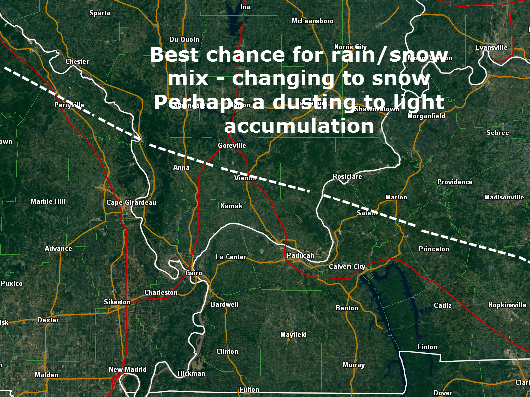
Light rain will spread through the region (mainly this afternoon). The rain may mix with snow from time to time. Rain may change to light snow before ending. Perhaps there will be enough moisture for a dusting or so of snow for parts of southern Illinois – believe if this were to occur it would be along a line from Carbondale to Marion, Illinois and then north/northeast. The line would shift a bit further southeast late this afternoon – that would take it into our northwest Kentucky counties. Iffy on whether we can squeak out accumulation.
Probabilities for snow:
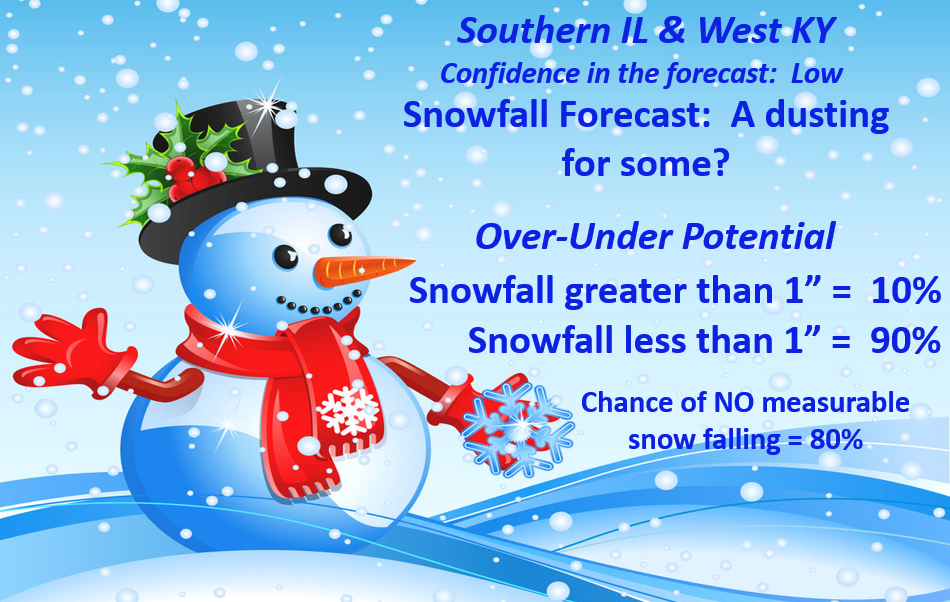
Another map showing you where a light accumulation can’t be ruled out – in and near. Again, temperatures are marginal. So, give me some room here for low expectations. Low confidence. I think you get the idea 🙂
Temperatures tonight will fall below freezing. Watch for a few slick spots if moisture remains on bridges and overpasses.
Below normal temperatures will continue into Friday. Moderating temperatures will finally arrive for the weekend. Highs will reach into the 50’s.
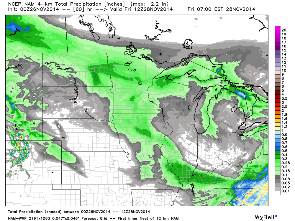
Rainfall totals today should be in the 0.05″-0.20″ range.
RADARS
We have regional radars and local city radars – if a radar does not seem to be updating then try another one. Occasional browsers need their cache cleared. You may also try restarting your browser. That usually fixes the problem. Occasionally we do have a radar go down. That is why I have duplicates. Thus, if one fails then try another one.
If you have any problems then please send me an email beaudodson@usawx.com
WEATHER RADAR PAGE – Click here
Current temperatures


Added the mention of the possibility of light accumulations of snow from this event.

No major concerns. Light rain and snow today will move out by later this evening. A few patchy slick spots are possible overnight and early Thursday morning. This would most likely occur if any moisture remains on roads after evening rain/snow showers come to an end.

The Wild Card gives you an idea of what might change that would cause the forecast to bust. A busted forecast means a forecast that does not verify. For example, if a winter storm (the area of low pressure) shifts its track 50 miles further south than expected, then that could cause a dramatic change in how much snow might or might not accumulate.
Wild card in this forecast – whether or not we see some snowflakes later today and this evening. Marginal event for accumulating snow.

Can we expect severe thunderstorms over the next 24 to 48 hours? Remember that a severe thunderstorm is defined as a thunderstorm that produces 58 mph winds or higher, quarter size hail or larger, and/or a tornado.
Thunderstorm threat level is ZERO. No severe weather through Sunday.


Will I need to take action?
Umbrellas might come in handy later today as some light rain and snow push through the area.
Otherwise, use care if snow does develop later this afternoon or tonight. There could be a few slick spots if temperatures fall fast enough while moisture remains on roadways.

Please visit your local National Weather Service Office by clicking here. The National Weather Service Office, for our region, is located in Paducah, Kentucky.

How much rain should this system produce over our region?
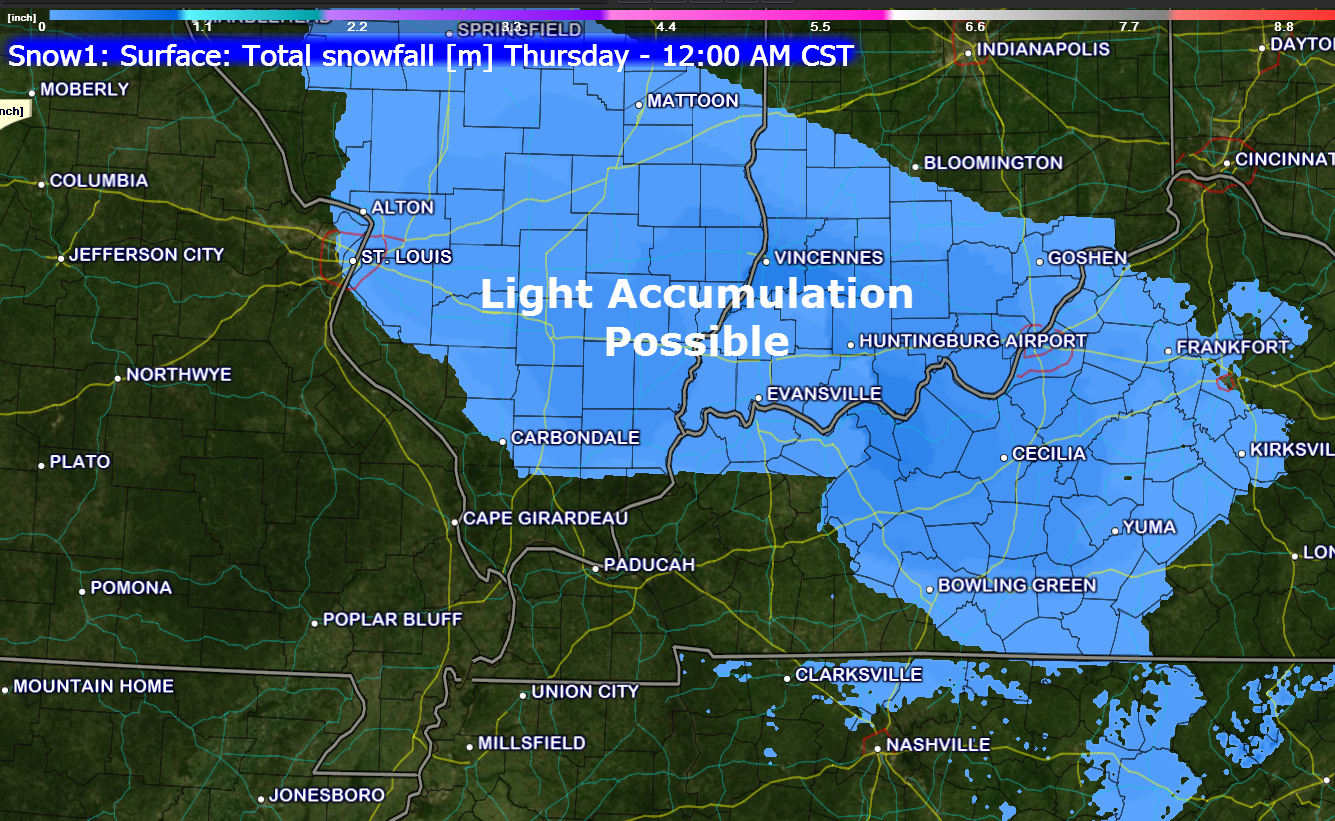
The latest rainfall forecast paints some light totals over our region.

You might see some flakes in the air today. A dusting of snow possible over parts of southern Illinois later today/tonight. This may extend into parts of northwest Kentucky.

Some additional precipitation chances will arrive by Saturday night into Monday. Right now it appears that it will be warm enough for an all rain event.
Temperatures over the weekend should rise into the 50’s. Temperatures will still be below normal – but hey, sure beats the 30’s and 40’s!!!
Next week looks warmer and perhaps wet. Stay tuned.
Short and brief today.
Safe travels today and tomorrow.
![]()
We have regional radars and local city radars – if a radar does not seem to be updating then try another one. Occasional browsers need their cache cleared. You may also try restarting your browser. That usually fixes the problem. Occasionally we do have a radar go down. That is why I have duplicates. Thus, if one fails then try another one.
If you have any problems then please send me an email beaudodson@usawx.com
WEATHER RADAR PAGE – Click here —
We also have a new national interactive radar – you can view that radar by clicking here.
Local interactive city radars include St Louis, Mt Vernon, Evansville, Poplar Bluff, Cape Girardeau, Marion, Paducah, Hopkinsville, Memphis, Nashville, Dyersburg, and all of eastern Kentucky – these are interactive radars. Local city radars – click here
NOTE: Occasionally you will see ground clutter on the radar (these are false echoes). Normally they show up close to the radar sites – including Paducah.

Regional Radar – Click on radar to take you our full radar page.


Regional Radar

Current WARNINGS (a warning means take action now). Click on your county to drill down to the latest warning information. Keep in mind that there can be a 2-3 minute delay in the updated warning information.
I strongly encourage you to use a NOAA Weather Radio or warning cell phone app for the most up to date warning information. Nothing is faster than a NOAA weather radio.


Many of my graphics are from www.weatherbell.com – a great resource for weather data, model data, and more


This blog was inspired by ABC 33/40’s Alabama Weather Blog – view their blog
Current tower cam view from the Weather Observatory- Click here for all cameras.

Southern Illinois Weather Observatory

The Weather Observatory

Southern Illinois Weather Observatory
WSIL TV 3 has a number of tower cameras. Click here for their tower camera page & Illinois Road Conditions

Marion, Illinois
WPSD TV 6 has a number of tower cameras. Click here for their tower camera page & Kentucky Road Conditions & Kentucky Highway and Interstate Cameras

Downtown Paducah, Kentucky
Benton, Kentucky Tower Camera – Click here for full view

Benton, Kentucky

I24 Paducah, Kentucky

I24 Mile Point 9 – Paducah, KY

I24 – Mile Point 3 Paducah, Kentucky

You can sign up for my AWARE email by clicking here I typically send out AWARE emails before severe weather, winter storms, or other active weather situations. I do not email watches or warnings. The emails are a basic “heads up” concerning incoming weather conditions.