

November 11, 2014: This forecast update covers far southern Illinois, far southeast Missouri, and far western Kentucky. See the coverage map on the right side of the blog.
Tuesday – Cloudy. Becoming windy. Mild this morning. A chance for light rain showers. Temperatures will peak this morning and then fall through the afternoon hours. Southwest winds at 5-10 mph. Winds turning out of the west/northwest this afternoon at 10-20 mph. Some higher gusts possible.
Morning School Bus Stop Weather – Cloudy. A chance for showers. Temperatures around 55 degrees. Southwest winds at 10 mph.
Afternoon School Bus Stop Weather – Cloudy. A chance for a shower. Temperatures falling into the 40’s Gusty west/northwest winds at 10-20 mph.
Tuesday night – Clearing sky conditions. Colder. Overnight lows down into the upper 20’s. Northwest winds at 5-10 mph.
Wednesday – A few clouds, otherwise sunny. Cold. High temperatures only in the lower 40’s. North winds at 10-15 mph.
Morning School Bus Stop Weather – A few clouds, otherwise sun. Cool. Temperature around 30 degrees. North winds at 5-10 mph.
Afternoon School Bus Stop Weather – Mostly sunny. Cool. Temperatures only in the lower 40’s. North winds at 10 mph.
Wednesday night – Some clouds. Cold. Lows in the middle 20’s. North winds at 10 mph.
Thursday – A few clouds, otherwise sunny. Cold. High temperatures may not get out of the 30’s. North winds at 5-10 mph.
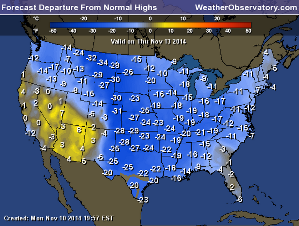
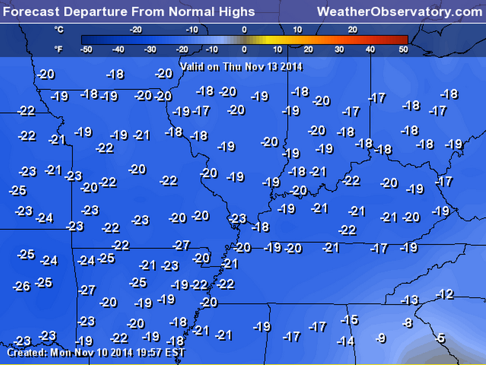
Speaking of Thursday
Let’s take a look at how many degrees BELOW normal readings will be. These are not actual temperatures. These numbers represent how many degrees below the averages temperatures will be. If the normal high is 62 degrees and we are 20 degrees below normal then that means highs would only be around 42 degrees.
Zoomed view

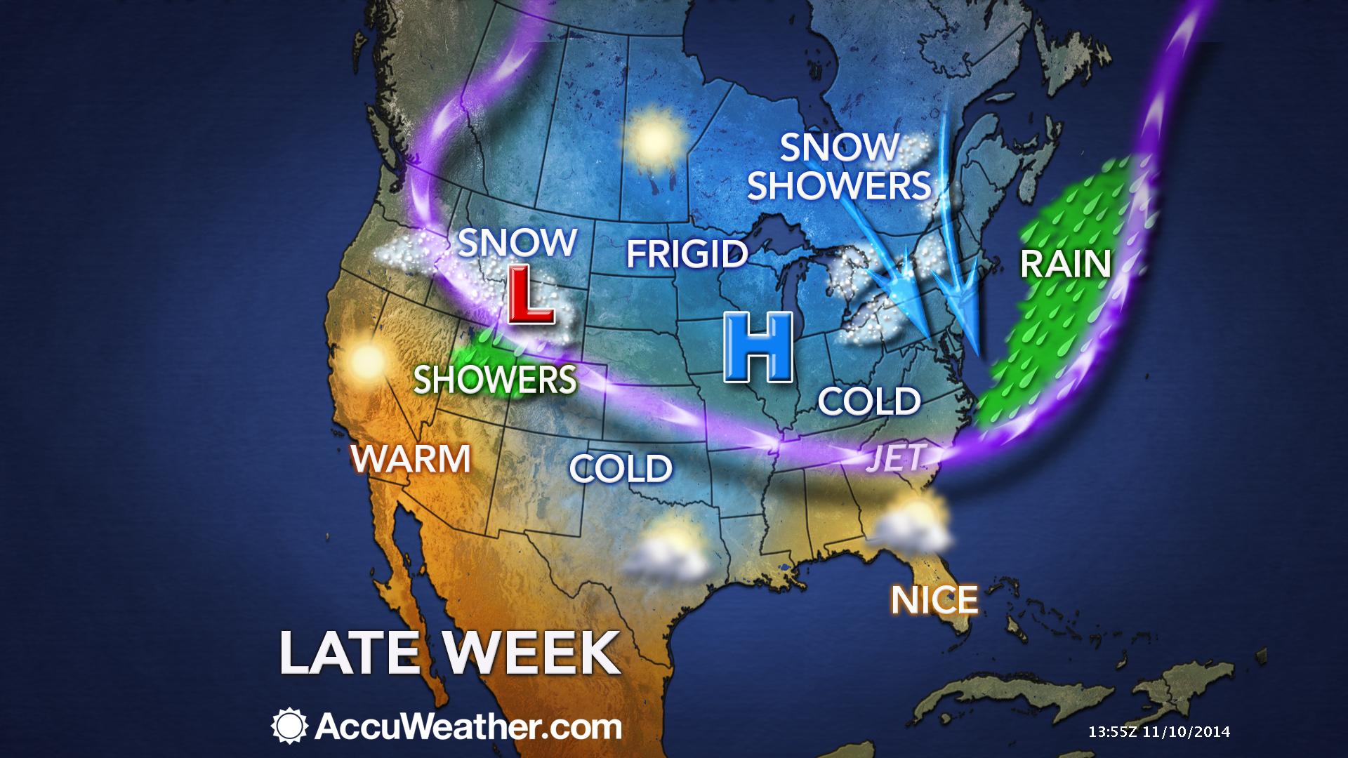
An explanation of what is happening in the atmosphere over the coming days.
A mild morning is on tap for the region. Temperatures are a bit warmer than expected, at this hour. The mild weather will end by this afternoon.
Our MUCH anticipated cold front is moving through the region this morning. The front will move across all of our counties by this afternoon. You will notice the winds turn out of the west/northwest. Temperatures will fall through the afternoon hours.
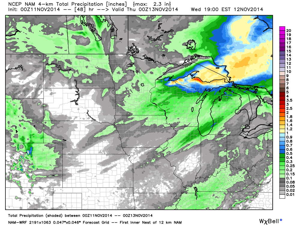
Here is the future-cast radar for Tuesday afternoon. Note the wind barbs. The winds behind the front out from the northwest. Note the winds ahead of the front. They are out of the south/southwest. The blue area represents light showers along the cold front.
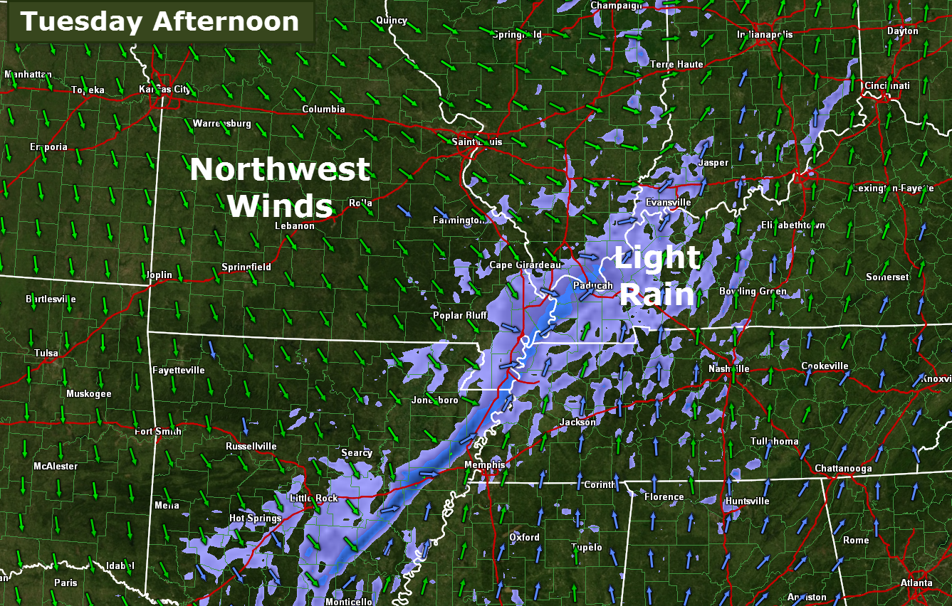
A band of light showers will accompany the front. Rainfall totals will be less than 0.25″. Some places may remain dry.
MUCH colder air will dominate the forecast into the weekend. We may struggle to get out of the 30’s on some days. This is WELL below normal temperatures. Normal highs for this time of the year are still in the 60’s.
Overnight lows over the coming days will dip into the 20’s. I would not be surprised to see some areas dip into the upper teens. Definitely a cold snap.
I continue to watch the weekend for some precipitation chances. Still iffy on whether much precipitation falls. If it were to fall then it would likely be snow or a wintry mix. This does not look to be a big deal. See the extended forecast discussion for down on this page.
A few graphics for your viewing pleasure 🙂
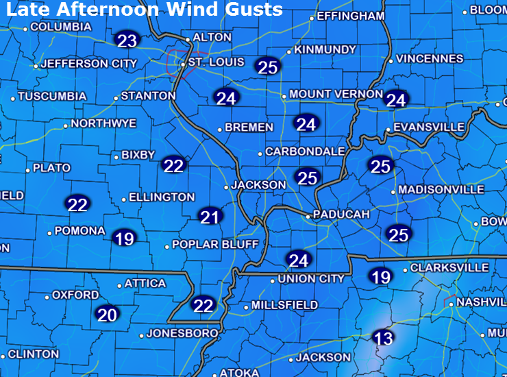
Let’s take a look at the forecast wind speeds for later this afternoon. You can see that winds should gust into the 20-25 mph range. This will make it feel even cooler.
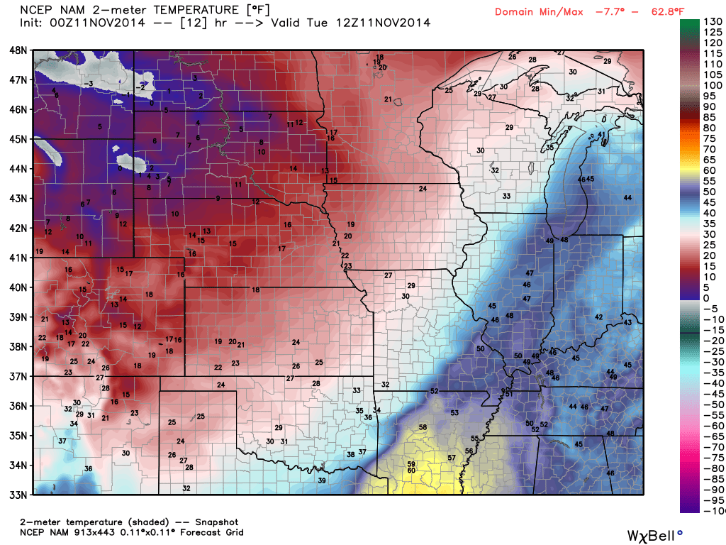
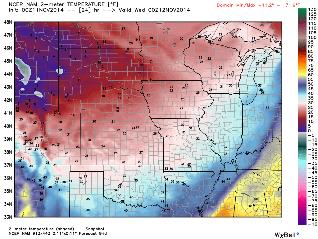
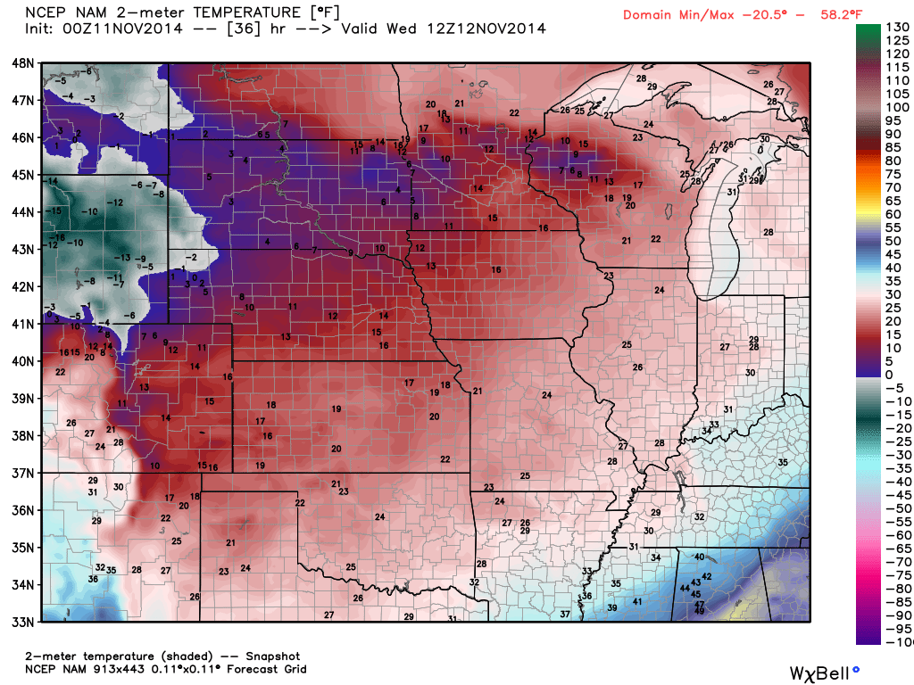
Now, let’s check out temperatures as the front pushes through the region.
6 AM Temperature map – you can see where we start out this morning. Note the warmer air east of the cold front. Note the colder air west of the cold front. Temperatures are even a little warmer than this map indicates.
Now, a bit later today. This is the 6 pm temperature map.
And finally, tomorrow morning at 6 am. Temperatures will dip into the 20’s.
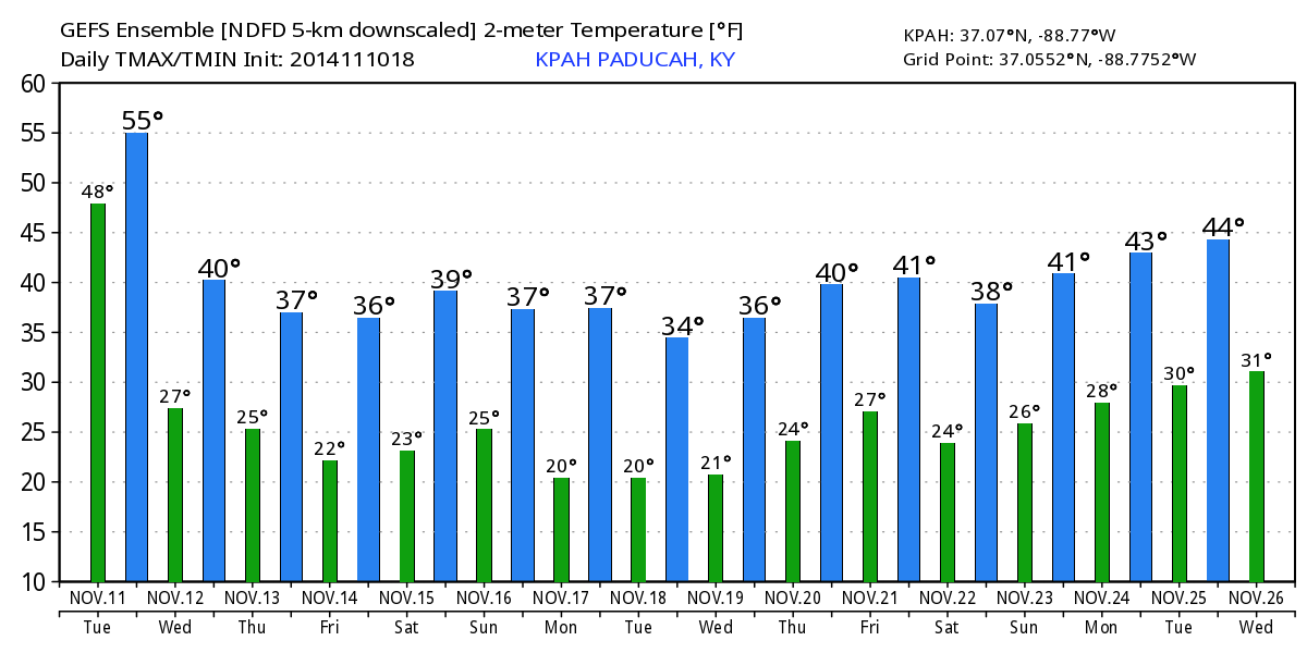
Check this graphic out (below). These are the expected high and low temperatures for Paducah, Kentucky. This map takes you into next week. This is very unusual. You rarely see this many days (in a row) with such cold temperatures (in the Month of November).
How about the windchill temperatures today and tomorrow? Gusty winds will make it feel cooler than the actual air temperatures. Here are the windchill maps.


Current regional temperatures

Current National Temperatures

Current wind speed map for the Missouri Valley

Satellite map to track the clouds. The gray and white areas would be cloud cover.


No major changes to the ongoing forecast. Tweaked winds just a little bit.

Cold weather! Plenty of cold air over the coming days. Temperatures will feel like December and January. WELL below normal temperatures for this time of the year.
Don’t forget our outdoor pets. Water bowls will freeze.

The Wild Card gives you an idea of what might change that would cause the forecast to bust. A busted forecast means a forecast that does not verify. For example, if a winter storm (the area of low pressure) shifts its track 50 miles further south than expected, then that could cause a dramatic change in how much snow might or might not accumulate.
Wild card in this forecast will be the overnight lows and highs for the coming days. Would not be surprised if a few spots dip into the upper teens before the weekend. Twenties will be common.

Can we expect severe thunderstorms over the next 24 to 48 hours? Remember that a severe thunderstorm is defined as a thunderstorm that produces 58 mph winds or higher, quarter size hail or larger, and/or a tornado.
Severe weather is not going to be a concern through Monday.
Thunderstorm threat level is zero.


Please visit your local National Weather Service Office by clicking here. The National Weather Service Office, for our region, is located in Paducah, Kentucky.
![]()
We have regional radars and local city radars – if a radar does not seem to be updating then try another one. Occasional browsers need their cache cleared. You may also try restarting your browser. That usually fixes the problem. Occasionally we do have a radar go down. That is why I have duplicates. Thus, if one fails then try another one.
If you have any problems then please send me an email beaudodson@usawx.com
WEATHER RADAR PAGE – Click here —
We also have a new national interactive radar – you can view that radar by clicking here.
Local interactive city radars include St Louis, Mt Vernon, Evansville, Poplar Bluff, Cape Girardeau, Marion, Paducah, Hopkinsville, Memphis, Nashville, Dyersburg, and all of eastern Kentucky – these are interactive radars. Local city radars – click here
NOTE: Occasionally you will see ground clutter on the radar (these are false echoes). Normally they show up close to the radar sites – including Paducah.

Regional Radar – Click on radar to take you our full radar page.


Regional Radar

Current WARNINGS (a warning means take action now). Click on your county to drill down to the latest warning information. Keep in mind that there can be a 2-3 minute delay in the updated warning information.
I strongly encourage you to use a NOAA Weather Radio or warning cell phone app for the most up to date warning information. Nothing is faster than a NOAA weather radio.


Missouri Warnings

Illinois Warnings

Kentucky Warnings
I have added a lot of new maps to the Southern Illinois Weather Observatory web-site. Check them out by clicking here.

How much rain should this system produce over our region?
Not much! Some light showers will accompany the cold front. These showers will linger into the afternoon hours. Some places might pick up 0.10″-0.20″ of rainfall. Other places will likely only record a trace. This is not going to be a significant rain producer.
Scale is on the right side of the image.

No winter weather concerns through Friday!

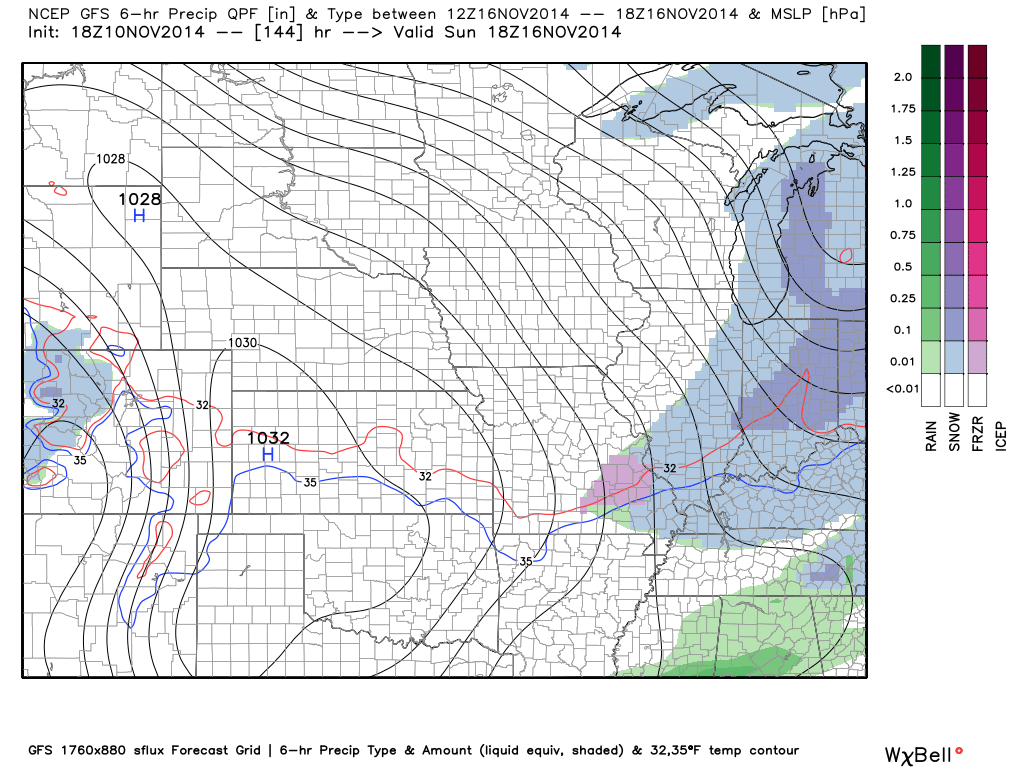
The long range forecast will be dominated by colder than normal temperatures. The big question is whether or not we can pick up some snow. It does appear a weak system will pass near our region over the weekend. This system might produce a few snowflakes or a rain/snow mix. It does not appear to be a big deal. I will continue to monitor for changes.
Here is the future-cast radar map from the GFS model. Note the blue represents light snow or a snow/rain mix. This would be Saturday night and Sunday.
The little thin blue line is the 32 degree line. You can see it over our local counties.
Additional precipitation chances will arrive next week and into the week of Thanksgiving. Still too soon to know whether those systems will bring rain, thunderstorms, or snow. Stay tuned.
Here is the latest 6-10 and 8-14 day temperature and precipitation outlooks. Will we be below or above normal? Check them out.


The latest 8-14 day temperature and precipitation outlook. Note the dates are at the top of the image. These maps DO NOT tell you how high or low temperatures or precipitation will be. They simply give you the probability as to whether temperatures or precipitation will be above or below normal.


Current tower cam view from the Weather Observatory- Click here for all cameras.

Southern Illinois Weather Observatory

The Weather Observatory

Southern Illinois Weather Observatory
WPSD TV 6 has a number of tower cameras. Click here for their tower camera page
& Kentucky Road Conditions & Kentucky Highway and Interstate Cameras

Downtown Paducah, Kentucky
Benton, Kentucky Tower Camera – Click here for full view

Benton, Kentucky
WSIL TV 3 has a number of tower cameras. Click here for their tower camera page
& Illinois Road Conditions

Marion, Illinois

You can sign up for my AWARE email by clicking here I typically send out AWARE emails before severe weather, winter storms, or other active weather situations. I do not email watches or warnings. The emails are a basic “heads up” concerning incoming weather conditions.