We have some great sponsors for the Weather Talk Blog. Please let our sponsors know that you appreciate their support for the Weather Talk Blog.
Milner and Orr Funeral Home and Cremation Services located in Paducah, Kentucky and three other western Kentucky towns – at Milner and Orr they believe in families helping families. You can find Milner and Orr on Facebook, as well.
![]()
.

For all of your families eye care needs. Visit their web-site here. Or, you can also visit their Facebook page.
.

Best at Enabling Body Shop Profitability since 1996. Located In Paducah Kentucky and Evansville Indiana; serving all customers in between. They provide Customer Service, along with all the tools necessary for body shops to remain educated and competitive. Click the logo above for their main web-site. You can find McClintock Preferred Finishes on Facebook, as well

Expressway Carwash and Express Lube are a locally owned and operated full service Carwash and Lube established in 1987. We have been proudly serving the community for 29 years now at our Park Avenue location and 20 years at our Southside location. We have been lucky enough to partner with Sidecar Deli in 2015, which allows us to provide our customers with not only quality service, but quality food as well. . If you haven’t already, be sure to make Expressway your one stop shop, with our carwash, lube and deli. For hours of operation and pricing visit www.expresswashlube.com or Expressway Carwash on Facebook.

TORNADO SHELTERS! Endrizzi’s Storm Shelters – For more information click here. Endrizzi Contracting and Landscaping can be found on Facebook, as well – click here
I have launched the new weather texting service! I could use your help. Be sure and sign up and fully support all of the weather data you see each day.
This is a monthly subscription service. Supporting this helps support everything else. The cost is $3 a month for one phone, $5 a month for three phones, and $10 a month for seven phones.
For more information visit BeauDodsonWeather.com
Or directly sign up at Weathertalk.com


This forecast update covers far southern Illinois, far southeast Missouri, and far western Kentucky. See the coverage map on the right side of the blog.
Remember that weather evolves. Check back frequently for updates, especially during active weather.

Friday Night – Mostly clear. Cool.
Temperatures: Lows in the lower to middle 50s
Winds: Winds southwest at 0-5 mph.
What is the chance for precipitation? 0%
Coverage of precipitation: None
My confidence in this part of the forecast verifying is High
Should I be concerned about snow or ice? No
Should I cancel my outdoor plans? No
Is severe weather expected? No
What impact is expected? None
Your Interactive City View Radars: Track the rain
Need a lightning tracker website? Here you go
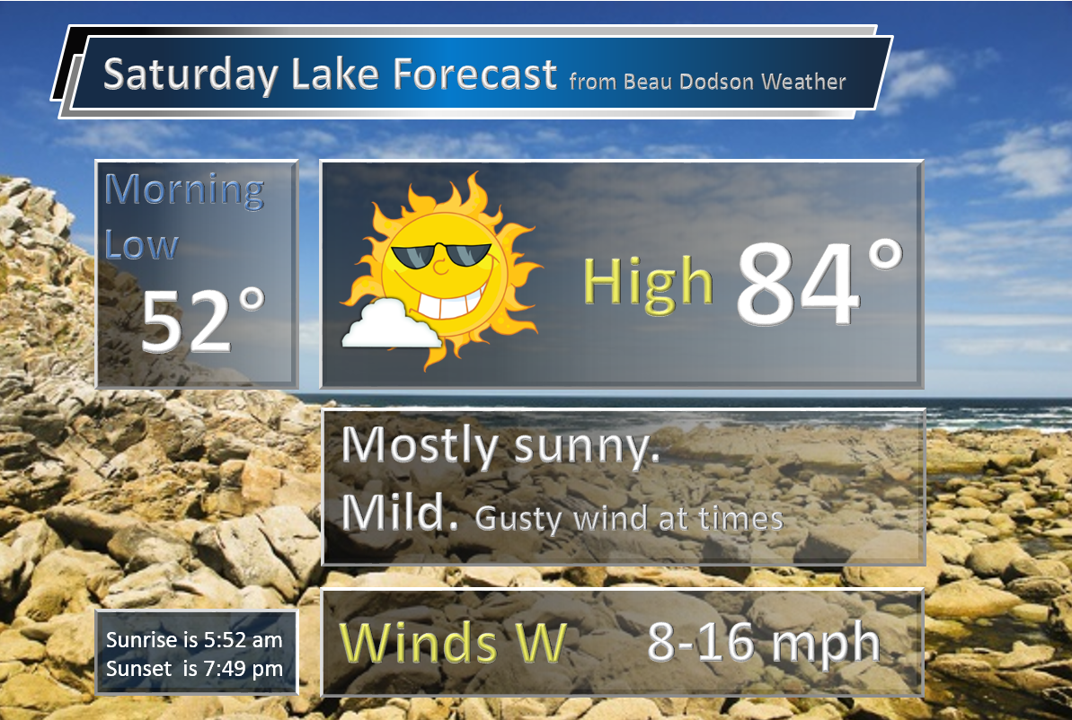
Saturday – Partly to mostly sunny and warmer.
Temperatures: High temperatures in the upper 70s to lower 80s
Winds: Southwest at 8-16 mph. Gusty at times.
What is the chance for precipitation? 20%
Coverage of precipitation? Isolated
My confidence in this part of the forecast verifying is Low
Should I be concerned about snow or ice? No
Should I cancel my outdoor plans? No
Is severe weather expected? No
What impact is expected? Most areas none. Wet roadways and lightning possible near the frontal boundary. Low confidence.
Saturday Night – Partly cloudy. Scattered showers and thunderstorms over northern parts of southern Illinois into northwest Kentucky.
Temperatures: Lows in the 55-60 degree range
Winds: Winds southwest winds at 4-8 mph.
What is the chance for precipitation? 40%-50% northern half of southern Illinois into northwest Kentucky.
Coverage of precipitation: Most likely none.
My confidence in this part of the forecast verifying is High
Should I be concerned about snow or ice? No
Should I cancel my outdoor plans? No
Is severe weather expected? Small chance near I65 and then into northwest Kentucky. Hail and gusty wind is the main concern.
What impact is expected? Maybe some wet roadways and lightning for our northern counties. Gusty winds. Can’t rule out a couple of strong storms over our northern counties.
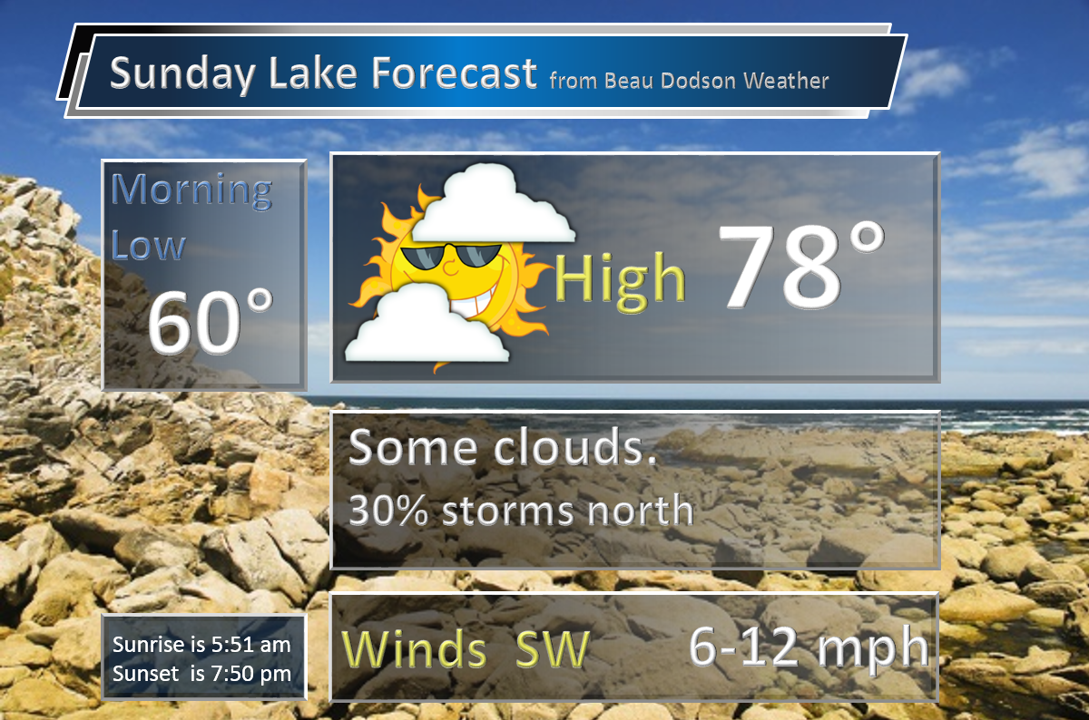
Sunday – Partly sunny. Increasing clouds through the day. Can’t rule out a thunderstorm along the I64 corridor into northwest Kentucky (northern parts of southern Illinois). And then perhaps southeast Missouri late in the day. Some showers may actually spread eastward across southeast Missouri Sunday afternoon.
Temperatures: High temperatures in the upper 70s to lower 80s. Temperatures could potentially vary across the region. The reason will be cloud cover.
Winds: Southwest at 5-10 mph with gusts to 15 mph.
What is the chance for precipitation? 30%-40% at any given location. Best chances north and west
Coverage of precipitation? Scattered
My confidence in this part of the forecast verifying is Medium
Should I be concerned about snow or ice? No
Should I cancel my outdoor plans? No, but monitor radars
Is severe weather expected? Unlikely
What impact is expected? Perhaps a few wet roadways and lightning.
Sunday Night – Partly cloudy. A scattered thunderstorm possible.
Temperatures: Lows in the 58-64 degree range
Winds: Winds south and southwest winds at 5 mph.
What is the chance for precipitation? 30%
Coverage of precipitation: Isolated to scattered
My confidence in this part of the forecast verifying is High
Should I be concerned about snow or ice? No
Should I cancel my outdoor plans? No
Is severe weather expected? Unlikely
What impact is expected? Wet roadways. Lightning.
Monday – Partly sunny. Mild. A chance for a thunderstorm.
Temperatures: High temperatures in the middle 70s
Winds: South and southwest winds at 5-10 mph with gusts to 20 mph
What is the chance for precipitation? 40%
Coverage of precipitation? Scattered
My confidence in this part of the forecast verifying is High
Should I be concerned about snow or ice? No
Should I cancel my outdoor plans? No, but monitor updates
Is severe weather expected? Monitor updates
What impact is expected? Wet roadways. Lightning.
Monday Night – Partly cloudy. A chance for thunderstorms.
Temperatures: Lows in the middle 60s
Winds: Winds south and southwest at 5-10 mph.
What is the chance for precipitation? 60%
Coverage of precipitation: Scattered to numerous
My confidence in this part of the forecast verifying is Medium
Should I be concerned about snow or ice? No
Should I cancel my outdoor plans? No, but monitor updates
Is severe weather expected? Monitor updates
What impact is expected? Wet roadways. Lightning.
Tuesday – Partly sunny and warm. A chance for showers and thunderstorms.
Temperatures: High temperatures in the 75-80 degree range
Winds: South winds at 8-16 mph.
What is the chance for precipitation? 60%
Coverage of precipitation? Scattered to numerous
My confidence in this part of the forecast verifying is Medium
Should I be concerned about snow or ice? No
Should I cancel my outdoor plans? No, but monitor updates
Is severe weather expected? Monitor updates
What impact is expected? Wet roadways. Lightning.
Tuesday Night – Partly cloudy. A chance for thunderstorms.
Temperatures: Lows in the middle 60s
Winds: Winds south and southwest at 5-10 mph.
What is the chance for precipitation? 40%-50%
Coverage of precipitation: Scattered to perhaps numerous early in the night.
My confidence in this part of the forecast verifying is Medium
Should I be concerned about snow or ice? No
Should I cancel my outdoor plans? No, but monitor updates
Is severe weather expected? Monitor updates
What impact is expected? Wet roadways. Lightning.
Wednesday – Partly sunny and warm. A thunderstorm possible.
Temperatures: High temperatures in the upper 70s to lower 80s
Winds: South and southwest winds at 4-8 mph
What is the chance for precipitation? 40%-50%
Coverage of precipitation? Scattered
My confidence in this part of the forecast verifying is Low
Should I be concerned about snow or ice? No
Should I cancel my outdoor plans? No, but monitor updates
Is severe weather expected? Unlikely
What impact is expected?
Wednesday Night – Partly cloudy. A thunderstorm possible.
Temperatures: Lows in the lower to middle 60s
Winds: Winds south and southwest at 5 mph.
What is the chance for precipitation? 40%-50%
Coverage of precipitation: Scattered
My confidence in this part of the forecast verifying is Low
Should I be concerned about snow or ice? No
Should I cancel my outdoor plans? No, but monitor updates
Is severe weather expected? Unlikely
What impact is expected?
Thursday – Partly sunny and warm. A thunderstorm possible.
Temperatures: High temperatures in the 74-78 degree range
Winds: Southwest winds at 4-8 mph
What is the chance for precipitation? 50%-60%
Coverage of precipitation? Scattered to perhaps numerous
My confidence in this part of the forecast verifying is Low
Should I be concerned about snow or ice? No
Should I cancel my outdoor plans? No
Is severe weather expected? Unlikely
What impact is expected?
Thursday Night – Partly cloudy. A shower possible.
Temperatures: Lows in the lower to middle 50s
Winds: Winds west at 5 mph.
What is the chance for precipitation? 30%
Coverage of precipitation: Isolated to Scattered
My confidence in this part of the forecast verifying is Low
Should I be concerned about snow or ice? No
Should I cancel my outdoor plans? No
Is severe weather expected? Unlikely
What impact is expected? None
Friday – Partly sunny.
Temperatures: High temperatures in the 74-78 degree range
Winds: West winds at 4-8 mph
What is the chance for precipitation? 20%
Coverage of precipitation? Scattered
My confidence in this part of the forecast verifying is Low
Should I be concerned about snow or ice? No
Should I cancel my outdoor plans? No
Is severe weather expected? No
What impact is expected? None
Friday Night – Partly cloudy. A thunderstorm possible.
Temperatures: Lows in the lower to middle 50s
Winds: Winds west at 5 mph.
What is the chance for precipitation? 20%-30%
Coverage of precipitation: None to scattered
My confidence in this part of the forecast verifying is Low
Should I be concerned about snow or ice? No
Should I cancel my outdoor plans? No
Is severe weather expected? No
What impact is expected? None
Saturday – Mostly sunny.
Temperatures: High temperatures in the 68 to 74 degree range.
Winds: West winds at 4-8 mph
What is the chance for precipitation? 0%
Coverage of precipitation? None
My confidence in this part of the forecast verifying is Low
Should I be concerned about snow or ice? No
Should I cancel my outdoor plans? No
Is severe weather expected? No
What impact is expected? None
Saturday Night – Partly cloudy.
Temperatures: Lows in the 48 to 56 degree range
Winds: Winds west at 5 mph.
What is the chance for precipitation? 20%
Coverage of precipitation: Scattered to none
My confidence in this part of the forecast verifying is Low
Should I be concerned about snow or ice? No
Should I cancel my outdoor plans? No
Is severe weather expected? No
What impact is expected? None
Sunday – Partly sunny. Monitoring for some more storms. Perhaps centered more south than north.
Temperatures: High temperatures in the 74 to 78 degree range.
Winds: West winds at 4-8 mph
What is the chance for precipitation? 20%
Coverage of precipitation? Scattered to none
My confidence in this part of the forecast verifying is Low
Should I be concerned about snow or ice? No
Should I cancel my outdoor plans? No
Is severe weather expected? No
What impact is expected? None
The weekend forecast is sponsored by Farmer and Company Real Estate. Click here to visit their site.

Keep in mind, thunderstorms are possible late Saturday night and Sunday over parts of southeast Missouri, southern Illinois, and northwest Kentucky. Some disagreement as to how far south to pull those precipitation chances. But, at least some storms on radar appears likely. Best chances north.

The School Bus Stop Forecast is sponsored by Heath Health and Wellness. Located next to Crowell Pools in Lone Oak, Kentucky.
Visit their web-site here. And. visit Heath Health Foods on Facebook!
Heath Health Foods is a locally owned and operated retail health and wellness store. Since opening in February 2006; the store has continued to grow as a ministry with an expanding inventory which also offers wellness appointments and services along with educational opportunities. Visit their web-site here. And. visit Heath Health Foods on Facebook!

Don’t forget to check out the Southern Illinois Weather Observatory web-site for weather maps, tower cams, scanner feeds, radars, and much more! Click here

An explanation of what is happening in the atmosphere over the coming days…
- All eyes on the weekend forecast. Nice for many.
- How far south will rain chances push on Saturday night into Sunday night. Incoming cold front.
- On/off thunderstorm chances much of next week. Locally heavy rain from time to time.
- Long range outlook for June is starting to look wetter than normal
Not too bad of a Friday for the region. More sun than Thursday (for the eastern counties of the region). Thursday’s high temperatures were lower than expected in the cloud cover area. I knew it would be cooler, but not that cool. Some places never got out of the 50s.
Today wasn’t as bad. A few spotty clouds. A bit warmer. Not too bad for May.
The good news is that we have a warm weekend ahead of us! Quite a bit of sun for most of the region.
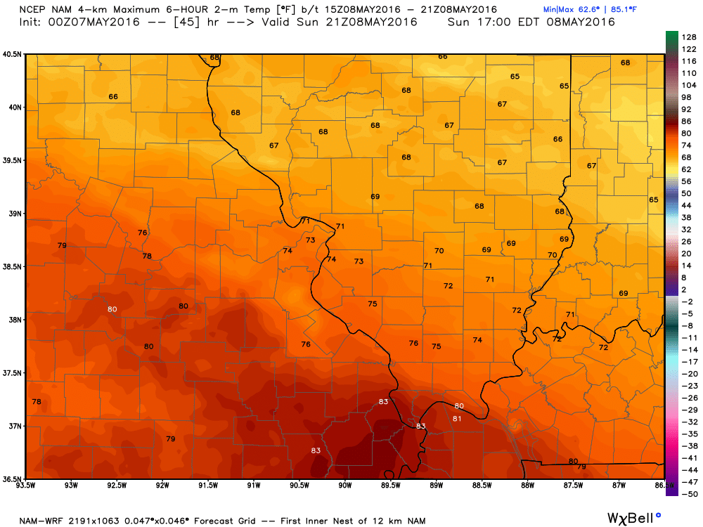
Check out these high temperatures for Saturday!
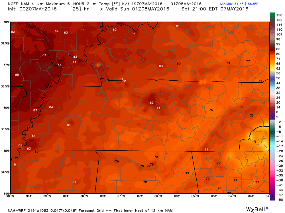
The bad news is that a cold front will approach our northern counties on Saturday night and Sunday. Showers and thunderstorms will develop right along and north of the front. How far south that front pushes is key to our weather forecast. Right now, subject to adjustments, the best chance of rain should be from Farmington, Missouri towards the northern parts of southern Illinois and then into northwest Kentucky. From there northward stands the best chance for precipitation.
Could it rain south of that line? Yes. It certainly could. But, the best chances will be further north. If the front does push further south than forecast then adjustments will need to be made.
If you are driving to St Louis this weekend then monitor updated forecasts. Some strong storms possible Saturday night and Sunday afternoon.
Here is basically the line where some precipitation is possible Saturday night into Sunday. Along and north of this line. At least a few showers and storms can’t be ruled out.
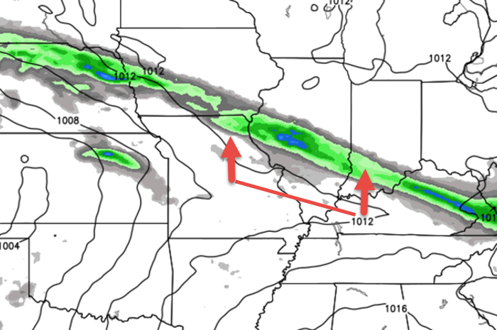
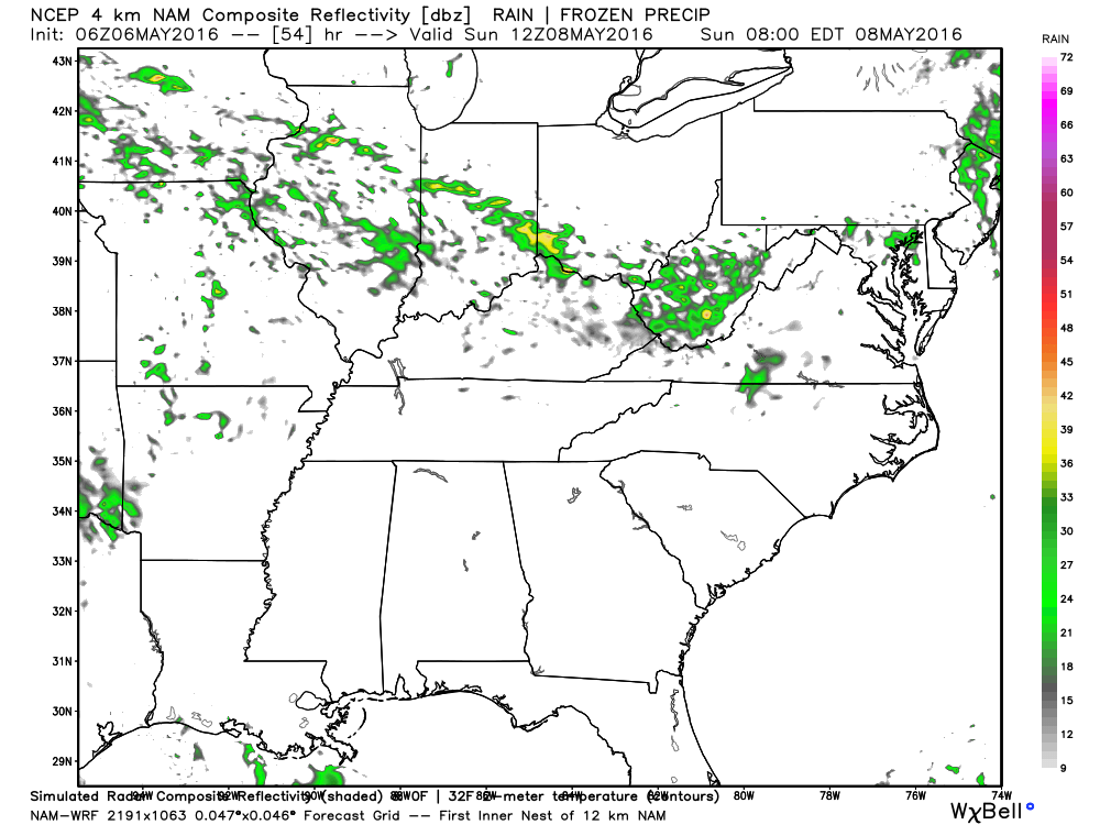
Here is the WRF guidance for this weekend. Notice the patches of green. That are scattered showers and thunderstorms on Saturday night and Sunday.
This first image is for early Sunday morning. We will have to wait and see how far south the front pushes on Saturday night. I suspect it will stay just to our north.
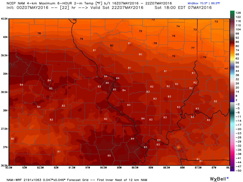
By Sunday afternoon a few more showers may push into our western counties, as well. This image below is from weatherbell. com and shows you the 1 pm time frame on Sunday
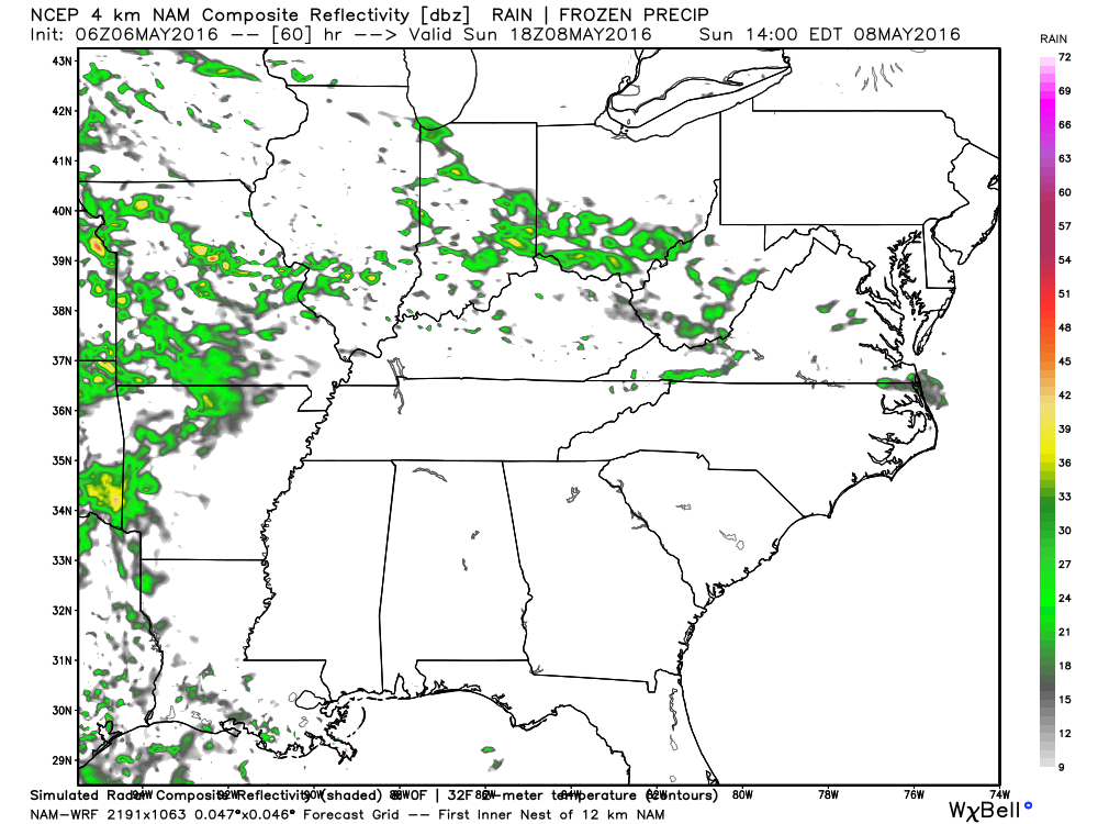
Notice the temperature difference for Sunday. Cloud cover could have an impact on Sunday high temperatures.
A series of disturbances will push out of the southwest United States from Sunday night into next Friday. This means a very unsettled pattern. I can’t rule out at least a chance for showers and storms almost every day next week.
I have placed the highest probabilities for showers and thunderstorms for Monday into Tuesday night/Wednesday morning. Confidence is lower as we move into Wednesday night into Friday.
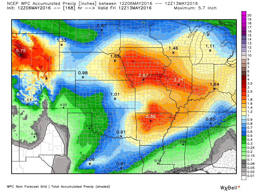
Rainfall totals will vary considerably. The reason for this is the potential for heavy thunderstorms. I can’t completely rule out severe weather. It is May, after all. It does not take much to produce severe storms in May. Monitor updates. At the very least a few storms could produce 40-50 mph wind gusts, nickel size hail, and frequent lightning. Heavy downpours, as well.
Between now and next Thursday we should experience 0.75″-1.50″ of rain across the region. And, some places could top two inches of rain. Placement of key features will determine who ends up with the heavier thunderstorms. Active pattern ahead of us. Timing the rain chances will be tricky. Monitor the probabilities for precipitation.
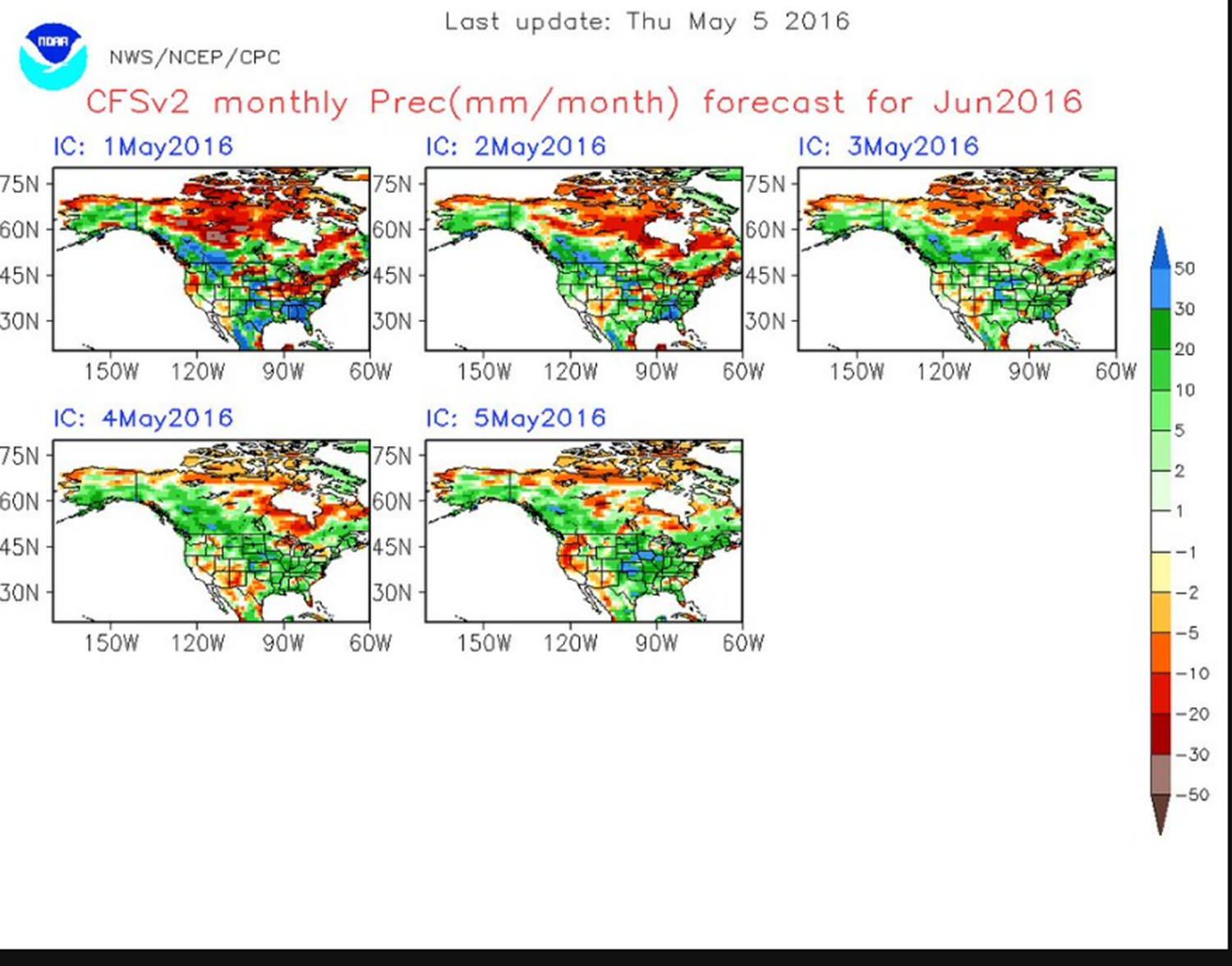
The chart below shows you the precipitation totals for June. Starting at the top left is the forecast made on May 1st. The second one was made on May 2nd. What we are watching for would be trends. Do the charts increase or decrease the numbers. The charts have been increasing numbers for June. But, these are just a few charts. Let’s keep monitoring. The pattern has been wet. Will it continue? That is the million dollar question. There are some extreme summer forecasts being floated around. Many saying hot and dry. But, not all. And, most of those are analog based forecasts. Analogs are forecasts made by looking at previous years and comparing the conditions this year. How does this year match up with previous years.
Click for larger views.
Let’s take a look at the current drought monitor. Our region looks pretty good. A bit wet, actually. Drought is to our west and to our east. Click for larger views.
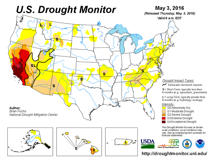
Zooming in on our region. Yellow indicates where it is a bit dry. But, not drought.
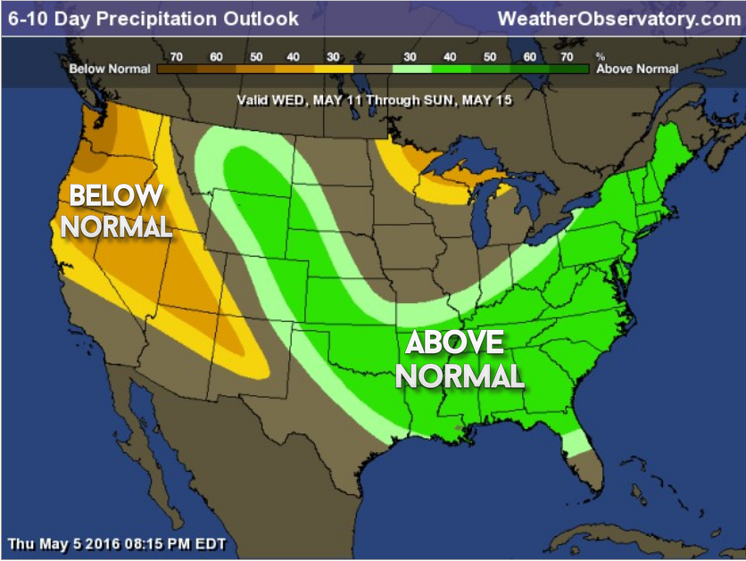
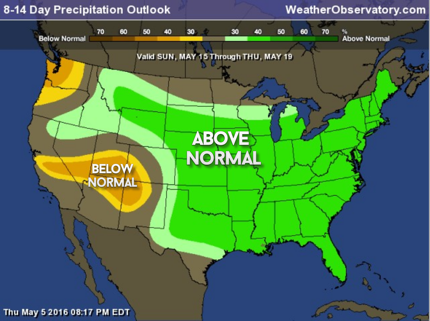
Here is the 6-10 and 8-14 day precipitation outlook. Odds favor above normal precipitation. Click for larger views.
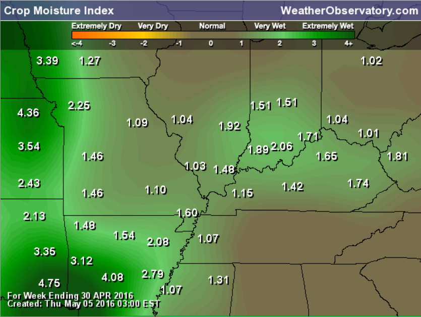
Our crop moisture index is wet. No surprise there. Click the image for a larger view.

Can we expect severe thunderstorms over the next 24 to 48 hours? Remember that a severe thunderstorm is defined as a thunderstorm that produces 58 mph winds or higher, quarter size hail or larger, and/or a tornado.
.
Friday night-Saturday morning: Severe weather is not anticipated.
Saturday night-Sunday afternoon: A few storms can’t be ruled out from Farmington, Missouri eastward into northwest Kentucky (close to the IL/IN/KY border). Further south and storm chances decrease. Severe weather is currently not anticipated. Some storms could, however, produce gusty winds, small hail, and frequent lightning.
Sunday night – Thursday: On and off thunderstorm chances. The threat for severe weather appears low, but perhaps not zero. Monitor updates.
.

.
..
I continue to update the timing of precipitation.
.

.
No concerns through Saturday morning. Perhaps our northern counties could experience a few storms Saturday night and Sunday. How far south those storms push is the real question. Not anticipating severe weather this weekend. Monitor updated forecasts, as always. Some storms could produce frequent lightning, small hail, and gusty winds.
.


How much precipitation should we expect over the next few days?
Unsettled pattern developing. But, complicated when it comes to the daily details.

Here are the current river stage forecasts. You can click your state and then the dot for your location. It will bring up the full forecast and hydrograph.
.
.

Here is the official 6-10 day and 8-14 day temperature and precipitation outlook. Check the date stamp at the top of each image (so you understand the time frame).
The forecast maps below are issued by the Weather Prediction Center (NOAA).


The latest 8-14 day temperature and precipitation outlook. Note the dates are at the top of the image. These maps DO NOT tell you how high or low temperatures or precipitation will be. They simply give you the probability as to whether temperatures or precipitation will be above or below normal.


Who do you trust for your weather information and who holds them accountable?
I have studied weather in our region since the late 1970’s. I have 37 years of experience in observing our regions weather patterns. My degree is in Broadcast Meteorology from Mississippi State University and an Associate of Science (AS). I am currently working on my Bachelor’s Degree in Geoscience.
My resume includes:
Member of the American Meteorological Society.
NOAA Weather-Ready Nation Ambassador.
Meteorologist for McCracken County Emergency Management. I served from 2005 through 2015.
I own and operate the Southern Illinois Weather Observatory.
Recipient of the Mark Trail Award, WPSD Six Who Make A Difference Award, Kentucky Colonel, and the Caesar J. Fiamma” Award from the American Red Cross.
In 2009 I was presented with the Kentucky Office of Highway Safety Award.
Recognized by the Kentucky House of Representatives for my service to the State of Kentucky leading up to several winter storms and severe weather outbreaks.
I am also President of the Shadow Angel Foundation which serves portions of western Kentucky and southern Illinois.
There is a lot of noise on the internet. A lot of weather maps are posted without explanation. Over time you should learn who to trust for your weather information.
My forecast philosophy is simple and straight forward.
- Communicate in simple terms
- To be as accurate as possible within a reasonable time frame before an event
- Interact with you on Twitter, Facebook, and the blog
- Minimize the “hype” that you might see on television or through other weather sources
- Push you towards utilizing wall-to-wall LOCAL TV coverage during severe weather events
I am a recipient of the Mark Trail Award, WPSD Six Who Make A Difference Award, Kentucky Colonel, and the Caesar J. Fiamma” Award from the American Red Cross. In 2009 I was presented with the Kentucky Office of Highway Safety Award. I was recognized by the Kentucky House of Representatives for my service to the State of Kentucky leading up to several winter storms and severe weather outbreaks.
If you click on the image below you can read the Kentucky House of Representatives Resolution.

Many of my graphics are from www.weatherbell.com – a great resource for weather data, model data, and more


You can sign up for my AWARE email by clicking here I typically send out AWARE emails before severe weather, winter storms, or other active weather situations. I do not email watches or warnings. The emails are a basic “heads up” concerning incoming weather conditions.