We have some great sponsors for the Weather Talk Blog. Please let our sponsors know that you appreciate their support for the Weather Talk Blog.
Milner and Orr Funeral Home and Cremation Services located in Paducah, Kentucky and three other western Kentucky towns – at Milner and Orr they believe in families helping families. You can find Milner and Orr on Facebook, as well.
![]()
.

For all of your families eye care needs. Visit their web-site here. Or, you can also visit their Facebook page.
.

Best at Enabling Body Shop Profitability since 1996. Located In Paducah Kentucky and Evansville Indiana; serving all customers in between. They provide Customer Service, along with all the tools necessary for body shops to remain educated and competitive. Click the logo above for their main web-site. You can find McClintock Preferred Finishes on Facebook, as well

Expressway Carwash and Express Lube are a locally owned and operated full service Carwash and Lube established in 1987. We have been proudly serving the community for 29 years now at our Park Avenue location and 20 years at our Southside location. We have been lucky enough to partner with Sidecar Deli in 2015, which allows us to provide our customers with not only quality service, but quality food as well. . If you haven’t already, be sure to make Expressway your one stop shop, with our carwash, lube and deli. For hours of operation and pricing visit www.expresswashlube.com or Expressway Carwash on Facebook.

TORNADO SHELTERS! Endrizzi’s Storm Shelters – For more information click here. Endrizzi Contracting and Landscaping can be found on Facebook, as well – click here
I have launched the new weather texting service! I could use your help. Be sure and sign up and fully support all of the weather data you see each day.
This is a monthly subscription service. Supporting this helps support everything else. The cost is $3 a month for one phone, $5 a month for three phones, and $10 a month for seven phones.
For more information visit BeauDodsonWeather.com
Or directly sign up at Weathertalk.com


This forecast update covers far southern Illinois, far southeast Missouri, and far western Kentucky. See the coverage map on the right side of the blog.
Remember that weather evolves. Check back frequently for updates, especially during active weather.

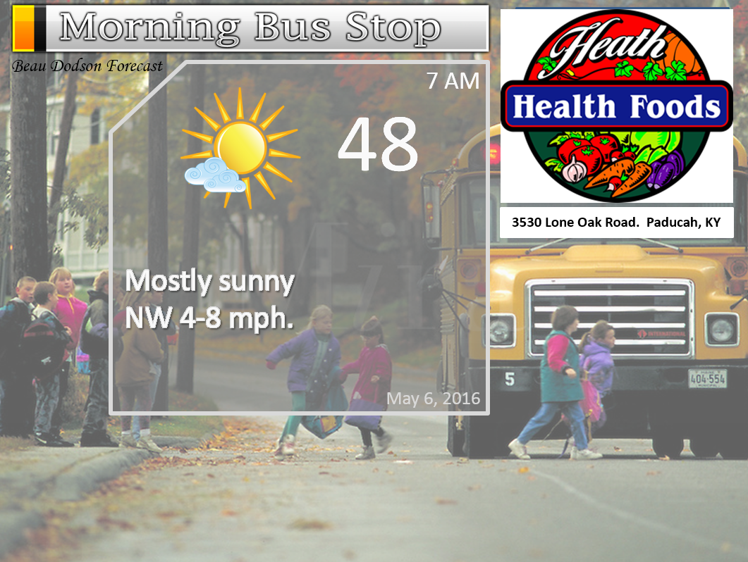
Thursday Night – Evening clouds giving way to mostly clear sky conditions. Cool.
Temperatures: Lows in the 44-48 degree range
Winds: Winds north and northwest winds at 5 mph.
What is the chance for precipitation? 0%
Coverage of precipitation: None
My confidence in this part of the forecast verifying is High
Should I be concerned about snow or ice? No
Should I cancel my outdoor plans? No
Is severe weather expected? No
What impact is expected? None
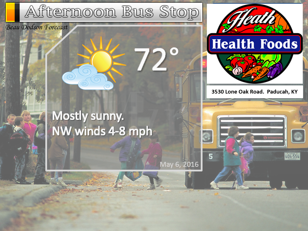
Friday – Mostly sunny.
Temperatures: High temperatures will be around 72-76
Winds: Northwest at 5-10 mph
What is the chance for precipitation? 0%
Coverage of precipitation? None
My confidence in this part of the forecast verifying is High
Should I be concerned about snow or ice? No
Should I cancel my outdoor plans? No
Is severe weather expected? No
What impact is expected? None
Friday Night – Mostly clear. Cool.
Temperatures: Lows in the lower to middle 50s
Winds: Winds southwest at 0-5 mph.
What is the chance for precipitation? 0%
Coverage of precipitation: None
My confidence in this part of the forecast verifying is High
Should I be concerned about snow or ice? No
Should I cancel my outdoor plans? No
Is severe weather expected? No
What impact is expected? None
Your Interactive City View Radars: Track the rain
Need a lightning tracker website? Here you go
Saturday – Partly sunny and warmer.
Temperatures: High temperatures in the upper 70s to lower 80s
Winds: Southwest at 5-10 mph
What is the chance for precipitation? 20%
Coverage of precipitation? Isolated
My confidence in this part of the forecast verifying is Low
Should I be concerned about snow or ice? No
Should I cancel my outdoor plans? No
Is severe weather expected? No
What impact is expected? Most areas none. Wet roadways and lightning possible near the frontal boundary. Low confidence.
Saturday Night – A few clouds. Cool. I can’t rule out some showers and perhaps even thunderstorms mainly along the I64 area.
Temperatures: Lows in the 55-60 degree range
Winds: Winds southwest winds at 4-8 mph.
What is the chance for precipitation? 20%-30% far northern counties.
Coverage of precipitation: Most likely none.
My confidence in this part of the forecast verifying is High
Should I be concerned about snow or ice? No
Should I cancel my outdoor plans? No
Is severe weather expected? No
What impact is expected? Maybe some wet roadways and lightning for our northern counties. Monitor updates for changes.
Sunday – Partly sunny. Can’t rule out a thunderstorm along the I64 corridor into northwest Kentucky. And then perhaps far western counties of southeast Missouri.
Temperatures: High temperatures in the upper 70s to lower 80s
Winds: Southwest at 5-10 mph
What is the chance for precipitation? 20%
Coverage of precipitation? Isolated. Dry over most of the region.
My confidence in this part of the forecast verifying is High
Should I be concerned about snow or ice? No
Should I cancel my outdoor plans? No
Is severe weather expected? Unlikely
What impact is expected? Most likely none. Perhaps a few wet roadways and lightning.
Sunday Night – Partly cloudy. A scattered thunderstorm possible.
Temperatures: Lows in the 58-64 degree range
Winds: Winds south and southwest winds at 5 mph.
What is the chance for precipitation? 30%
Coverage of precipitation: Isolated to scattered
My confidence in this part of the forecast verifying is High
Should I be concerned about snow or ice? No
Should I cancel my outdoor plans? No
Is severe weather expected? Unlikely
What impact is expected? Wet roadways. Lightning.
Monday – Partly sunny. Mild. A chance for a thunderstorm.
Temperatures: High temperatures in the middle 70s
Winds: South and southwest winds at 5-10 mph with gusts to 20 mph
What is the chance for precipitation? 40%
Coverage of precipitation? Scattered
My confidence in this part of the forecast verifying is Medium
Should I be concerned about snow or ice? No
Should I cancel my outdoor plans? No, but monitor updates
Is severe weather expected? Monitor updates
What impact is expected? Wet roadways. Lightning.
Monday Night – Partly cloudy. A chance for thunderstorms.
Temperatures: Lows in the middle 60s
Winds: Winds south and southwest at 5-10 mph.
What is the chance for precipitation? 40%-60%
Coverage of precipitation: Scattered
My confidence in this part of the forecast verifying is Medium
Should I be concerned about snow or ice? No
Should I cancel my outdoor plans? No, but monitor updates
Is severe weather expected? Monitor updates
What impact is expected? Wet roadways. Lightning.
Tuesday – Partly sunny and warm. A chance for showers and thunderstorms.
Temperatures: High temperatures in the 75-80 degree range
Winds: South winds at 8-16 mph.
What is the chance for precipitation? 40%-60%
Coverage of precipitation? Scattered
My confidence in this part of the forecast verifying is Low
Should I be concerned about snow or ice? No
Should I cancel my outdoor plans? No, but monitor updates
Is severe weather expected? Monitor updates
What impact is expected? Wet roadways. Lightning.
Tuesday Night – Partly cloudy. A chance for thunderstorms.
Temperatures: Lows in the middle 60s
Winds: Winds south and southwest at 5-10 mph.
What is the chance for precipitation? 40%-50%
Coverage of precipitation: Scattered
My confidence in this part of the forecast verifying is Low
Should I be concerned about snow or ice? No
Should I cancel my outdoor plans? No, but monitor updates
Is severe weather expected? Monitor updates
What impact is expected? Wet roadways. Lightning.
Wednesday – Partly sunny and warm. A thunderstorm possible.
Temperatures: High temperatures in the upper 70s to lower 80s
Winds: South and southwest winds at 4-8 mph
What is the chance for precipitation? 50%-60%
Coverage of precipitation? Scattered
My confidence in this part of the forecast verifying is Low
Should I be concerned about snow or ice? No
Should I cancel my outdoor plans? No, but monitor updates
Is severe weather expected? Unlikely
What impact is expected?
Wednesday Night – Partly cloudy. A thunderstorm possible.
Temperatures: Lows in the lower to middle 60s
Winds: Winds south and southwest at 5 mph.
What is the chance for precipitation? 40%-50%
Coverage of precipitation: Scattered
My confidence in this part of the forecast verifying is Low
Should I be concerned about snow or ice? No
Should I cancel my outdoor plans? No, but monitor updates
Is severe weather expected? Unlikely
What impact is expected?
Thursday – Partly sunny and warm. A thunderstorm possible.
Temperatures: High temperatures in the 74-78 degree range
Winds: Southwest winds at 4-8 mph
What is the chance for precipitation? 40%-50%
Coverage of precipitation? Scattered
My confidence in this part of the forecast verifying is Low
Should I be concerned about snow or ice? No
Should I cancel my outdoor plans? No
Is severe weather expected? Unlikely
What impact is expected?
Thursday Night – Partly cloudy. A shower possible.
Temperatures: Lows in the lower to middle 50s
Winds: Winds west at 5 mph.
What is the chance for precipitation? 30%
Coverage of precipitation: Isolated to Scattered
My confidence in this part of the forecast verifying is Low
Should I be concerned about snow or ice? No
Should I cancel my outdoor plans? No
Is severe weather expected? Unlikely
What impact is expected? None
Friday – Partly sunny. A chance for showers and thunderstorms.
Temperatures: High temperatures in the 74-78 degree range
Winds: West winds at 4-8 mph
What is the chance for precipitation? 40%
Coverage of precipitation? Scattered
My confidence in this part of the forecast verifying is Low
Should I be concerned about snow or ice? No
Should I cancel my outdoor plans? No
Is severe weather expected? No
What impact is expected? None
Friday Night – Partly cloudy.
Temperatures: Lows in the lower to middle 50s
Winds: Winds west at 5 mph.
What is the chance for precipitation? 10%
Coverage of precipitation: None
My confidence in this part of the forecast verifying is Low
Should I be concerned about snow or ice? No
Should I cancel my outdoor plans? No
Is severe weather expected? No
What impact is expected? None
Saturday – Mostly sunny.
Temperatures: High temperatures in the 68 to 74 degree range.
Winds: West winds at 4-8 mph
What is the chance for precipitation? 0%
Coverage of precipitation? None
My confidence in this part of the forecast verifying is Low
Should I be concerned about snow or ice? No
Should I cancel my outdoor plans? No
Is severe weather expected? No
What impact is expected? None
Saturday Night – Partly cloudy.
Temperatures: Lows in the 48 to 56 degree range
Winds: Winds west at 5 mph.
What is the chance for precipitation? 0%
Coverage of precipitation: None
My confidence in this part of the forecast verifying is Low
Should I be concerned about snow or ice? No
Should I cancel my outdoor plans? No
Is severe weather expected? No
What impact is expected? None
Sunday – Mostly sunny.
Temperatures: High temperatures in the 74 to 78 degree range.
Winds: West winds at 4-8 mph
What is the chance for precipitation? 0%
Coverage of precipitation? None
My confidence in this part of the forecast verifying is Low
Should I be concerned about snow or ice? No
Should I cancel my outdoor plans? No
Is severe weather expected? No
What impact is expected? None
The School Bus Stop Forecast is sponsored by Heath Health and Wellness. Located next to Crowell Pools in Lone Oak, Kentucky.
Visit their web-site here. And. visit Heath Health Foods on Facebook!

The School Bus Stop Forecast is sponsored by Heath Health and Wellness. Located next to Crowell Pools in Lone Oak, Kentucky.
Visit their web-site here. And. visit Heath Health Foods on Facebook!
Heath Health Foods is a locally owned and operated retail health and wellness store. Since opening in February 2006; the store has continued to grow as a ministry with an expanding inventory which also offers wellness appointments and services along with educational opportunities. Visit their web-site here. And. visit Heath Health Foods on Facebook!

Don’t forget to check out the Southern Illinois Weather Observatory web-site for weather maps, tower cams, scanner feeds, radars, and much more! Click here

An explanation of what is happening in the atmosphere over the coming days…
- A warming trend in the charts
- We might see some 80’s this weekend
- Thunderstorm chances this weekend?
- Our next good chance for storms will arrive early next week
The main weather story will be the eventual warming trend this coming weekend. If we can squeak out plenty of sunshine then temperatures should rise into the 70s and perhaps 80s across the region on both Saturday and Sunday. High temperatures will be controlled by cloud cover. More clouds and cooler temperatures. Less clouds and we should maximize our temperature potential.
A cold front will dip into our region on Saturday night into Sunday afternoon. How far south the front will push is questionable, at best. If the front stays a few counties further north then I believe most of the region will remain dry on both Saturday and Sunday.
If showers and thunderstorms form then the best chance would be from Farmington, Missouri across the northern part of southern Illinois and then into northwest Kentucky. I will post some charts below.
Confidence is rather low as to just how far south the front pushes. Hopefully I will have a better handle on that for the next update. Just keep the above in mind.
Otherwise, the rest of the area should expect quite a bit of sun this weekend and warm temperatures.
We will have on and off rain and thunderstorm chances next week. Beginning Sunday night and lasting right on into Thursday. The best chances for rain and storms will likely be on Monday and Monday night. Then again on Tuesday night and Wednesday morning. I will be monitoring Wednesday night and Thursday for rain chances, as well.
It is possible that most of next week will have at least some chance for scattered showers and thunderstorms. Warm and humid, as well.
Temperatures next week will be highly dependent on cloud cover and placement of precipitation. The atmosphere will have the potential of producing upper 70s and 80s. But, the question will be cloud cover.
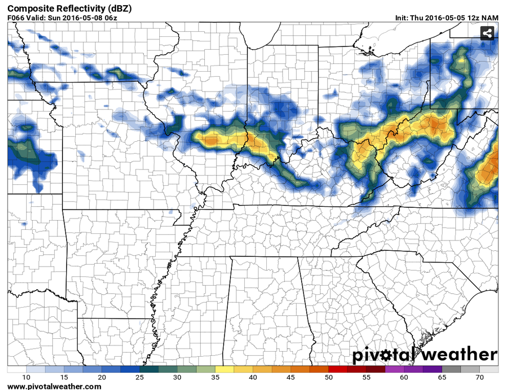
Let me show you the latest NAM guidance. It brings the front close to our region on Saturday night and Sunday. But, perhaps far enough north that we don’t have widespread storms in our region. Another system approaches from the west on Sunday afternoon and evening.
This first image is for Saturday night around 1 am. You can see some precipitation painted just to our north. Approaching our far northern counties.
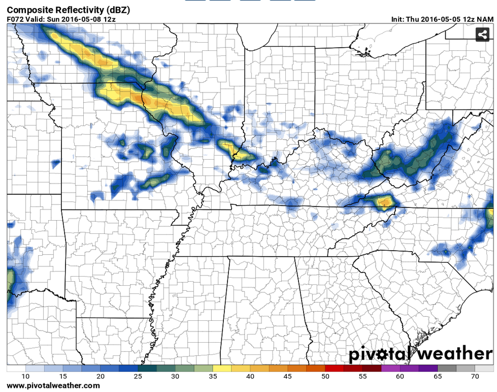
This next image is for Sunday morning at 7 am. Again, some showers and storms painted in and near our region. This will be highly dependent on how far south the front moves.
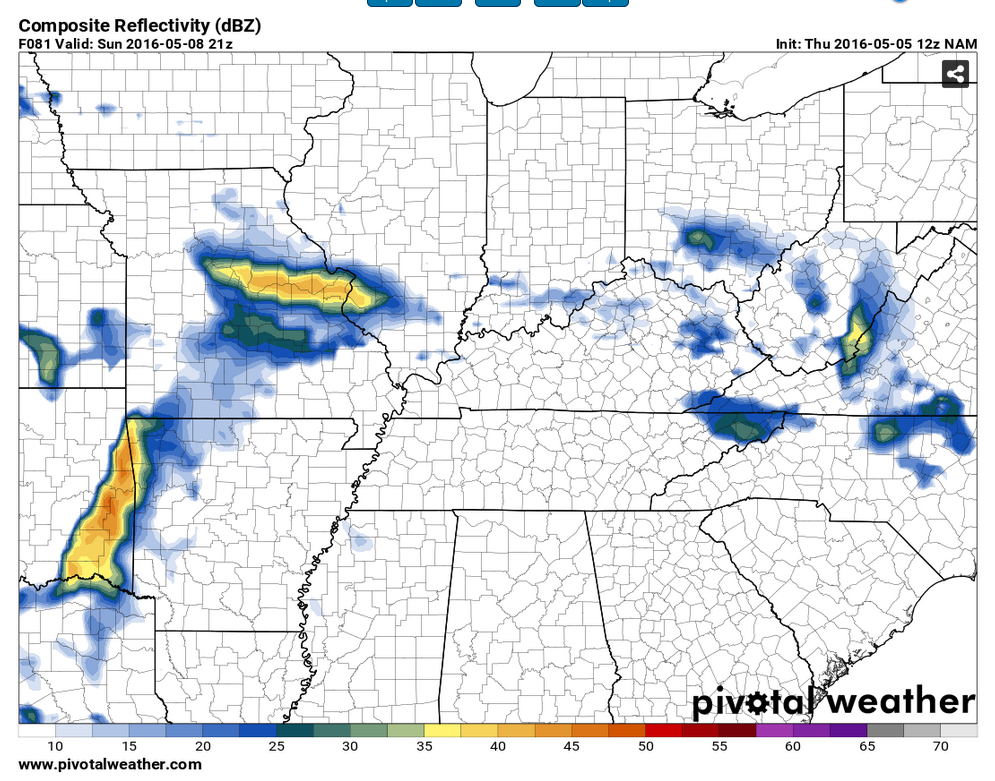
This last image is for Sunday afternoon. Notice some storms approaching from the west. That is our next weather maker.

Can we expect severe thunderstorms over the next 24 to 48 hours? Remember that a severe thunderstorm is defined as a thunderstorm that produces 58 mph winds or higher, quarter size hail or larger, and/or a tornado.
.
Thursday-Saturday morning: Severe weather is not anticipated.
Saturday night-Sunday afternoon: A few storms can’t be ruled out from Farmington, Missouri eastward into northwest Kentucky (close to the IL/IN/KY border). Further south and storm chances decrease. Severe weather is currently not anticipated.
Sunday night – Thursday: On and off thunderstorm chances. The threat for severe weather appears low, but perhaps not zero. Monitor updates.
.

.
..
I updated precipitation chances for each period of time.
.

.
No concerns through Saturday morning. Perhaps our northern counties could experience a few storms Saturday night and Sunday.
.


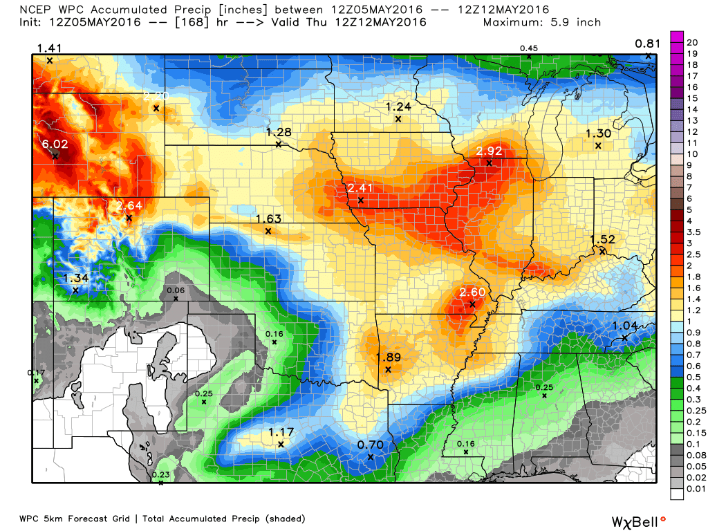
How much precipitation should we expect over the next few days?
Unsettled pattern developing. But, complicated when it comes to the daily details.
.

Here are the current river stage forecasts. You can click your state and then the dot for your location. It will bring up the full forecast and hydrograph.
.
.

Here is the official 6-10 day and 8-14 day temperature and precipitation outlook. Check the date stamp at the top of each image (so you understand the time frame).
The forecast maps below are issued by the Weather Prediction Center (NOAA).


The latest 8-14 day temperature and precipitation outlook. Note the dates are at the top of the image. These maps DO NOT tell you how high or low temperatures or precipitation will be. They simply give you the probability as to whether temperatures or precipitation will be above or below normal.


Who do you trust for your weather information and who holds them accountable?
I have studied weather in our region since the late 1970’s. I have 37 years of experience in observing our regions weather patterns. My degree is in Broadcast Meteorology from Mississippi State University and an Associate of Science (AS). I am currently working on my Bachelor’s Degree in Geoscience.
My resume includes:
Member of the American Meteorological Society.
NOAA Weather-Ready Nation Ambassador.
Meteorologist for McCracken County Emergency Management. I served from 2005 through 2015.
I own and operate the Southern Illinois Weather Observatory.
Recipient of the Mark Trail Award, WPSD Six Who Make A Difference Award, Kentucky Colonel, and the Caesar J. Fiamma” Award from the American Red Cross.
In 2009 I was presented with the Kentucky Office of Highway Safety Award.
Recognized by the Kentucky House of Representatives for my service to the State of Kentucky leading up to several winter storms and severe weather outbreaks.
I am also President of the Shadow Angel Foundation which serves portions of western Kentucky and southern Illinois.
There is a lot of noise on the internet. A lot of weather maps are posted without explanation. Over time you should learn who to trust for your weather information.
My forecast philosophy is simple and straight forward.
- Communicate in simple terms
- To be as accurate as possible within a reasonable time frame before an event
- Interact with you on Twitter, Facebook, and the blog
- Minimize the “hype” that you might see on television or through other weather sources
- Push you towards utilizing wall-to-wall LOCAL TV coverage during severe weather events
I am a recipient of the Mark Trail Award, WPSD Six Who Make A Difference Award, Kentucky Colonel, and the Caesar J. Fiamma” Award from the American Red Cross. In 2009 I was presented with the Kentucky Office of Highway Safety Award. I was recognized by the Kentucky House of Representatives for my service to the State of Kentucky leading up to several winter storms and severe weather outbreaks.
If you click on the image below you can read the Kentucky House of Representatives Resolution.

Many of my graphics are from www.weatherbell.com – a great resource for weather data, model data, and more


You can sign up for my AWARE email by clicking here I typically send out AWARE emails before severe weather, winter storms, or other active weather situations. I do not email watches or warnings. The emails are a basic “heads up” concerning incoming weather conditions.