May 7, 2018
Monday Forecast Details
Forecast: Mostly sunny. A few clouds. Warm.
Temperatures: MO ~ 72 to 77 IL ~ 72 to 75 KY ~ 72 to 75 TN ~ 72 to 76
What is the chance of precipitation? MO ~ 0% IL ~ 0% KY ~ 0% TN ~ 0%
Coverage of precipitation: None
Winds: North and northeast at 5 to 10 mph with gusts to 16 mph
What impacts are anticipated from the weather? None
My confidence in the forecast verifying: High
Is severe weather expected? No
The NWS defines severe weather as 58 mph wind or great, 1″ hail or larger, and/or tornadoes
Should I cancel my outdoor plans? No
Sunrise: 5:53 AM
Monday Night Forecast Details:
Forecast: Mostly clear. A few passing clouds.
Temperatures: MO ~ 48 to 54 IL ~ 48 to 54 KY ~ 48 to 54 TN ~ 50 to 55
What is the chance of precipitation? MO ~ 0% IL ~ 0% KY ~ 0% TN ~ 0%
Coverage of precipitation: None
Winds: Northeast and east at 5 to 10 mph
What impacts are anticipated from the weather? None
My confidence in the forecast verifying: High
Is severe weather expected? No
The NWS defines severe weather as 58 mph wind or great, 1″ hail or larger, and/or tornadoes
Should I cancel my outdoor plans? No
Sunset: 7:48 PM
May 8, 2018
Tuesday Forecast Details
Forecast: Mostly sunny.
Temperatures: MO ~ 74 to 78 IL ~ 74 to 76 KY ~ 74 to 76 TN ~ 74 to 78
What is the chance of precipitation? MO ~ 0% IL ~ 0% KY ~ 0% TN ~ 0%
Coverage of precipitation: None
Winds: Northeast at 6 to 12 mph
What impacts are anticipated from the weather? None
My confidence in the forecast verifying: High
Is severe weather expected? No
The NWS defines severe weather as 58 mph wind or great, 1″ hail or larger, and/or tornadoes
Should I cancel my outdoor plans? No
Sunrise: 5:52 AM
Tuesday Night Forecast Details:
Forecast: Partly cloudy. Some increase in clouds late. A slight chance of a few showers and thunderstorms. Best chances would be over southeast Missouri and southwest Illinois.
Temperatures: MO ~ 54 to 58 IL ~ 53 to 56 KY ~ 53 to 56 TN ~ 55 to 60
What is the chance of precipitation? MO ~ 30% IL ~ 30% KY ~ 20% TN ~ 20%
Coverage of precipitation: Scattered late
Winds: East and southeast at 5 to 10 mph
What impacts are anticipated from the weather? Wet roadways after midnight. Lightning.
My confidence in the forecast verifying: Medium
Is severe weather expected? No
The NWS defines severe weather as 58 mph wind or great, 1″ hail or larger, and/or tornadoes
Should I cancel my outdoor plans? No
Sunset: 7:49 PM
May 9, 2018
Wednesday Forecast Details
Forecast: A mix of sun and clouds. A chance of thunderstorms. Some storms could be strong.
Temperatures: MO ~ 75 to 80 IL ~ 75 to 80 KY ~ 75 to 80 TN ~ 75 to 80
What is the chance of precipitation? MO ~ 40% IL ~ 40% KY ~ 40% TN ~ 40%
Coverage of precipitation: Scattered
Winds: South 10 to 20 mph
What impacts are anticipated from the weather? Wet roads. Lightning. Monitor the hail and strong wind threat.
My confidence in the forecast verifying: Medium
Is severe weather expected? Some storms could be intense with hail and strong winds. Monitor updates.
The NWS defines severe weather as 58 mph wind or great, 1″ hail or larger, and/or tornadoes
Should I cancel my outdoor plans? No, but monitor updated forecasts and radars.
Sunrise: 5:51 AM
Wednesday Night Forecast Details:
Forecast: Cloudy. A chance of showers and thunderstorms. Monitor the risk of strong storms.
Temperatures: MO ~ 60 to 65 IL ~ 60 to 65 KY ~ 60 to 65 TN ~ 60 to 65
What is the chance of precipitation? MO ~ 50% IL ~ 50% KY ~ 40% TN ~ 40%
Coverage of precipitation: Scattered to perhaps numerous
Winds: South and southwest at 7 to 14 mph
What impacts are anticipated from the weather? Wet roadways. Lightning. Monitor the risk of hail and strong winds.
My confidence in the forecast verifying: Medium
Is severe weather expected? Monitor updates. Some storms could be strong.
The NWS defines severe weather as 58 mph wind or great, 1″ hail or larger, and/or tornadoes
Should I cancel my outdoor plans? Have a plan B. Monitor updates and radars.
Sunset: 7:51 PM
May 10, 2018
Thursday Forecast Details
Forecast: Partly sunny. Quite warm. A chance of widely scattered thunderstorms.
Temperatures: MO ~ 80 to 85 IL ~ 80 to 85 KY ~ 80 to 85 TN ~ 80 to 85
What is the chance of precipitation? MO ~ 20% IL ~ 20% KY ~ 20% TN ~ 20%
Coverage of precipitation: Widely scattered
Winds: Southwest at 7 to 14 mph
What impacts are anticipated from the weather? Wet roadways. Lightning.
My confidence in the forecast verifying: Medium
Is severe weather expected? Some storms could be intense.
The NWS defines severe weather as 58 mph wind or great, 1″ hail or larger, and/or tornadoes
Should I cancel my outdoor plans? No, but monitor updates and check radars.
Sunrise: 5:50 AM
Thursday Night Forecast Details:
Forecast: Partly cloudy and mild. A chance of scattered thunderstorms.
Temperatures: MO ~ 60 to 65 IL ~ 60 to 65 KY ~ 60 to 65 TN ~ 60 to 65
What is the chance of precipitation? MO ~ 30% IL ~ 30% KY ~ 30% TN ~ 30%
Coverage of precipitation: Scattered
Winds: Southwest at 5 to 10 mph
What impacts are anticipated from the weather? Wet roadways. Lightning.
My confidence in the forecast verifying: Medium
Is severe weather expected? Unlikely, but monitor updates.
The NWS defines severe weather as 58 mph wind or great, 1″ hail or larger, and/or tornadoes
Should I cancel my outdoor plans? No, but check updated forecasts and radars.
Sunset: 7:51 PM
May 11, 2018
Friday Forecast Details
Forecast: Mostly sunny. Quite warm.
Temperatures: MO ~ 80 to 85 IL ~ 80 to 85 KY ~ 80 to 85 TN ~ 80 to 85
What is the chance of precipitation? MO ~ 0% IL ~ 0% KY ~ 0% TN ~ 0%
Coverage of precipitation: None
Winds: South at 5 to 10 mph
What impacts are anticipated from the weather? None
My confidence in the forecast verifying: Medium
Is severe weather expected? No
The NWS defines severe weather as 58 mph wind or great, 1″ hail or larger, and/or tornadoes
Should I cancel my outdoor plans? No
Sunrise: 5:49 AM
Friday Night Forecast Details:
Forecast: Mostly clear. A few late night clouds over our northern counties. Mild.
Temperatures: MO ~ 62 to 66 IL ~ 62 to 66 KY ~ 62 to 66 TN ~ 62 to 66
What is the chance of precipitation? MO ~ 0% IL ~ 0% KY ~ 0% TN ~ 0%
Coverage of precipitation: None
Winds: South at 5 to 10 mph
What impacts are anticipated from the weather? None
My confidence in the forecast verifying: Medium
Is severe weather expected? No
The NWS defines severe weather as 58 mph wind or great, 1″ hail or larger, and/or tornadoes
Should I cancel my outdoor plans? No
Sunset: 7:52 PM
May 12, 2018
Saturday Forecast Details
Forecast: Mostly sunny. Some afternoon cumulus clouds. Very warm.
Temperatures: MO ~ 83 to 86 IL ~ 83 to 86 KY ~ 83 to 86 TN ~ 83 to 86
What is the chance of precipitation? MO ~ 10% IL ~ 10% KY ~ 10% TN ~ 10%
Coverage of precipitation: Most likely none
Winds: South at 5 to 10 mph with gusts to 15 mph
What impacts are anticipated from the weather? Most likely none
My confidence in the forecast verifying: Medium
Is severe weather expected? No
The NWS defines severe weather as 58 mph wind or great, 1″ hail or larger, and/or tornadoes
Should I cancel my outdoor plans? No
Sunrise: 5:48 AM
Saturday Night Forecast Details:
Forecast: Mostly clear. A few passing clouds.
Temperatures: MO ~ 62 to 66 IL ~ 62 to 66 KY ~ 62 to 66 TN ~ 62 to 66
What is the chance of precipitation? MO ~ 0% IL ~ 0% KY ~ 0% TN ~ 0%
Coverage of precipitation: None
Winds: South at 7 to 14 mph
What impacts are anticipated from the weather? None
My confidence in the forecast verifying: No
Is severe weather expected? No
The NWS defines severe weather as 58 mph wind or great, 1″ hail or larger, and/or tornadoes
Should I cancel my outdoor plans? No
Sunset: 7:43 PM
May 12, 2018
Sunday Forecast Details
Forecast: Partly sunny. A chance of an afternoon thunderstorm.
Temperatures: MO ~ 83 to 86 IL ~ 83 to 86 KY ~ 83 to 86 TN ~ 83 to 86
What is the chance of precipitation? MO ~ 20% IL ~ 20% KY ~ 20% TN ~ 20%
Coverage of precipitation:
Winds:
What impacts are anticipated from the weather?
My confidence in the forecast verifying:
Is severe weather expected?
The NWS defines severe weather as 58 mph wind or great, 1″ hail or larger, and/or tornadoes
Should I cancel my outdoor plans?
Sunrise: 5:48 AM
Sunday Night Forecast Details:
Forecast: Partly cloudy. A chance of a thunderstorm.
Temperatures: MO ~ 62 to 66 IL ~ 62 to 66 KY ~ 62 to 66 TN ~ 62 to 66
What is the chance of precipitation? MO ~ 20% IL ~ 20% KY ~ 20% TN ~ 20%
Coverage of precipitation:
Winds:
What impacts are anticipated from the weather?
My confidence in the forecast verifying:
Is severe weather expected?
The NWS defines severe weather as 58 mph wind or great, 1″ hail or larger, and/or tornadoes
Should I cancel my outdoor plans?
Sunset: 7:53 PM
Sunday, May 6, 2018
A brief update on today’s weather.
Radar link below.
Hello, fellow weather watchers, friends, and enthusiasts.
I hope you are having a nice weekend. Yes, we had some rain (for some) on Saturday, but at least it is still warm.
Maybe we can finally put to rest the cold temperatures (at least during the day). We still have some chilly nights ahead.
Speaking of rain. There were some isolated reports of flooding yesterday. This was mainly over our far eastern counties where isolated spots picked up more than three inches of rain. An oddity from yesterday’s weather.
A mixed bag forecast today. Clouds will increase from the north (some of you already have clouds).
A few showers and thunderstorms will develop as a fast moving system slides in from the north. A few storms could produce pea size hail. Not anticipating any severe weather. Lightning, of course will be a concern if a thunderstorm forms.
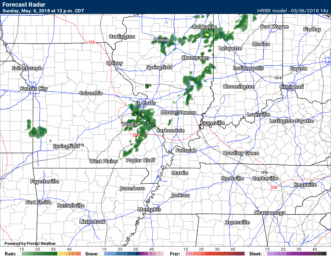
Here is the Hrrr future-cast radar.
This won’t be exact. It is simply a model’s interpretation of today’s weather. Take the general idea that there will be precipitation on radar as we move through today. Some will remain dry. Some will pick up a quick 0.10″ to 0.30″ of rain.
Highs today will range from the upper 70’s to lower 80’s. Not too bad for early May.
Lows tonight will dip into the 50’s (cool). Highs on Monday will rise into the 68 to 74 degree range. A bit cooler behind our cold front.
I am monitoring Wednesday into Thursday for additional storms. Too early to know if severe weather is a concern. Stay tuned.
Enjoy your Sunday!
Radar link
http://weatherobservatory.com/weather-radar.htm
Interactive Radars:
Interactive live weather radar page. Choose the city nearest your location. If one of the city radars won’t load then try a nearby one. Click here.

Questions? Broken links? Other?
You may email me at beaudodson@usawx.com

The National Weather Service defines a severe thunderstorm as one that produces quarter size hail or larger, 58 mph winds or greater, and/or a tornado.
Sunday and Sunday night: Isolated thunderstorms Sunday afternoon could produce lightning and pea size hail.
Monday through Thursday: Monitor updates. Some storms could be intense Wednesday and Wednesday night. Additional storms are possible Thursday.
![]()
Interactive live weather radar page. Choose the city nearest your location. If one of the cities does not work then try a nearby one. Click here.
National map of weather watches and warnings. Click here.
Storm Prediction Center. Click here.
Weather Prediction Center. Click here.

Live lightning data: Click here.

Interactive GOES R satellite. Track clouds. Click here.

Here are the latest local river stage forecast numbers Click Here.
Here are the latest lake stage forecast numbers for Kentucky Lake and Lake Barkley Click Here.

WeatherBrains Episode 641
Weather Brains is a weekly podcast/video for those who love weather and want more!
Joining us for this episode is SPC Lead Forecaster John Hart. John is actually in the mountains of Colorado where he has been panning for gold. As far back as he can remember, he had always dreamed of being a lead forecaster for the SELS unit in Kansas City which is now called the SPC. After attending college in St. Louis, he worked at Channel 2 there for a while. Then, a few weeks after graduation he was lucky enough to get a job at the National Weather Service in Charleston, West Virginia, and interned there for two years. He was involved with a few computer programming projects there that got his name known, so when a job opened at SELS, he was able to get it. Since then, he’s been in this unit, but worked multiple jobs. He became a meso-forecaster in 1995, and then a lead forecaster in 2000.
John considers the events of April 27, 2011, to be the biggest event that he will experience in his career. But the show title comes from a comment John made about how no event is a slam dunk, there are always uncertainties in any weather event.
Other discussions in this weekly podcast include topics like:
- Extremes: 103 at Rio Grande Village, TX, and 19 at Rosscommon, MI
- Severe wx forecast Central US next couple of days
- Hail and high wind from West TX to NB today
Previous episodes can be viewed by clicking here.

We offer interactive local city live radars and regional radars. If a radar does not update then try another one. If a radar does not appear to be refreshing then hit Ctrl F5. You may also try restarting your browser.
The local city view radars also have clickable warnings.
During the winter months, you can track snow and ice by clicking the winterize button on the local city view interactive radars.
You may email me at beaudodson@usawx.com
Find me on Facebook!

Find me on Twitter!

Did you know that a portion of your monthly subscription helps support local charity projects?
You can learn more about those projects by visiting the Shadow Angel Foundation website and the Beau Dodson News website.

I encourage subscribers to use the app vs regular text messaging. We have found text messaging to be delayed during severe weather. The app typically will receive the messages instantly. I recommend people have three to four methods of receiving their severe weather information.
Remember, my app and text alerts are hand typed and not computer generated. You are being given personal attention during significant weather events.
