WeatherTalk monthly operating costs can top $2000.00. Your $3 subscription helps pay for those costs. I work for you.
For $3 a month you can receive the following. You may choose to receive these via your WeatherTalk app or regular text messaging.
- Severe weather app/text alerts from my keyboard to your app/cell phone. These are hand typed by Beau. During tornado outbreaks, you will receive numerous app/text messages telling you exactly where the tornado is located.
- Daily forecast app/texts from my computer to your app/cell phone.
- Social media links sent directly to your app/cell phone. When I update the blog, videos, or Facebook you will receive the link.
- AWARE emails. These emails keep you well ahead of the storm. They give you several days of lead time before significant weather events.
- Direct access to Beau via text and email. Your very own personal meteorologist. I work for you!
- Missouri and Ohio Valley centered video updates
- Long-range weather videos
- Week one, two, three and four temperature and precipitation outlooks.
- Monthly outlooks.
- Your subscription also will help support several local charities.
Haven’t you subscribed? Subscribe at www.beaudodsonweather.com

Example of a recent severe weather alert. I issued this well before the official tornado warning. You would have had plenty of time for you and your family to seek shelter.


Your $3 per month also helps support these local charity projects.

I encourage subscribers to use the app vs regular text messaging. We have found text messaging to be delayed during severe weather. The app typically will receive the messages instantly. I recommend people have three to four methods of receiving their severe weather information.
Remember, my app and text alerts are hand typed and not computer generated. You are being given personal attention during significant weather events.

WWW.WEATHERTALK.COM subscribers, here is my day to day schedule for your weather products.


Interactive live weather radar page. Choose the city nearest your location. If one of the city radars won’t load then try a nearby one. Click here.
.
Thursday Forecast Details
Forecast: Partly to mostly cloudy. Warm and humid. Intervals of showers and thunderstorms. Some storms could be severe with high winds and hail. Heavy rain where storms occur.
Temperatures: MO ~ 86 to 90 IL ~ 86 to 90 KY ~ 86 to 90 TN ~ 86 to 90
What is the chance of precipitation? MO ~ 70% IL ~ 70% KY ~ 70% TN ~ 70%
Coverage of precipitation: At times, widespread
Winds: Southwest at 6 to 12 mph with gusts to 20 mph
What impacts are anticipated from the weather? Wet roads and lightning. Heavy rain possible. Hail and high winds possible. Flash flooding.
My confidence in the forecast verifying: Medium
Is severe weather expected? Severe storms are likely. Large hail and damaging wind being the main concern. Low end tornado risk, as well.
The NWS defines severe weather as 58 mph wind or great, 1″ hail or larger, and/or tornadoes
Should I cancel my outdoor plans? Monitor updates and radars
UV Index: 9 to 11 High
Sunrise: 5:36 AM
Thursday Night Forecast Details:
Forecast: Partly to mostly cloudy. Numerous evening showers and storms. Some storms could be severe. Locally heavy rain.
Temperatures: MO ~ 68 to 72 IL ~ 68 to 72 KY ~ 68 to 72 TN ~ 68 to 72
What is the chance of precipitation? MO ~ 70% IL ~ 70% KY ~ 70% TN ~ 70%
Coverage of precipitation: Scattered to perhaps numerous
Winds: South and southwest at 5 to 10 mph
What impacts are anticipated from the weather? Wet roadways. Lightning. Locally heavy rain. Hail and high winds. Flash flooding possible in the heaviest downpours.
My confidence in the forecast verifying: Medium
Is severe weather expected? Some storms could become severe.
The NWS defines severe weather as 58 mph wind or great, 1″ hail or larger, and/or tornadoes
Should I cancel my outdoor plans? Monitor radars and updates. Rain is possible.
Sunset: 8:09 PM
Moonrise: 10:01 PM Waning Gibbous
Moonset: 7:18 AM
June 01, 2018
Friday Forecast Details
Forecast: Partly sunny. Hot and muggy. Widely scattered showers and thunderstorms.
Temperatures: MO ~ 88 to 94 IL ~ 88 to 94 KY ~ 88 to 94 TN ~ 88 to 94
What is the chance of precipitation? MO ~ 20% IL ~ 20% KY ~ 30% TN ~ 30%
Coverage of precipitation: Isolated to widely scattered
Winds: West and southwest at 5 to 10 mph
What impacts are anticipated from the weather? Wet roads and lightning. Heavy rain possible.
My confidence in the forecast verifying: Medium
Is severe weather expected? Isolated reports of small hail and down burst winds are again possible
The NWS defines severe weather as 58 mph wind or great, 1″ hail or larger, and/or tornadoes
Should I cancel my outdoor plans? No, but check radars
UV Index: 10 High
Sunrise: 5:36 AM
Friday Night Forecast Details:
Forecast: Partly cloudy. Warm and humid. An isolated thunderstorm possible.
Temperatures: MO ~ 66 to 74 IL ~ 68 to 72 KY ~ 68 to 70 TN ~ 68 to 72
What is the chance of precipitation? MO ~ 20% IL ~ 20% KY ~ 20% TN ~ 20%
Coverage of precipitation: Isolated
Winds: Variable at 4 to 8 mph
What impacts are anticipated from the weather? Wet roadways. Lightning. Locally heavy rain.
My confidence in the forecast verifying: Medium
Is severe weather expected? Unlikely
The NWS defines severe weather as 58 mph wind or great, 1″ hail or larger, and/or tornadoes
Should I cancel my outdoor plans? No, but check radars
Sunset: 8:09 PM
Moonrise: 10:43 PM Waning Gibbous
Moonset: 8:06 AM
June 02, 2018
Saturday Forecast Details
Forecast: Partly sunny. Hot and humid. Scattered showers and locally heavy thunderstorms.
Temperatures: MO ~ 86 to 90 IL ~ 86 to 90 KY ~ 86 to 90 TN ~ 86 to 90
What is the chance of precipitation? MO ~ 40% IL ~ 30% KY ~ 30% TN ~ 30%
Coverage of precipitation: Scattered
Winds: South and southeast at 5 to 10 mph with gusts to 14
What impacts are anticipated from the weather? Scattered wet roads and lightning. Heavy rain possible where storms occur. Monitor the severe weather risk.
My confidence in the forecast verifying: Medium
Is severe weather expected? Some storms could approach severe levels. Monitor updates.
The NWS defines severe weather as 58 mph wind or great, 1″ hail or larger, and/or tornadoes
Should I cancel my outdoor plans? No, but check radars
UV Index: 10 High
Sunrise: 5:35 AM
Saturday Night Forecast Details:
Forecast: Partly cloudy. Warm and humid. Scattered thunderstorms possible.
Temperatures: MO ~ 65 to 70 IL ~ 64 to 68 KY ~ 65 to 70 TN ~ 65 to 70
What is the chance of precipitation? MO ~ 40% IL ~ 40% KY ~ 40% TN ~ 40%
Coverage of precipitation: Scattered
Winds: Southwest at 5 to 10 mph. Winds becoming variable.
What impacts are anticipated from the weather? Wet roadways. Lightning. Locally heavy rain.
My confidence in the forecast verifying: Medium
Is severe weather expected? Monitor updates
The NWS defines severe weather as 58 mph wind or great, 1″ hail or larger, and/or tornadoes
Should I cancel my outdoor plans? No, but check radars
Sunset: 8:09 PM
Moonrise: 11:31 PM Waning Gibbous
Moonset: 8:57 AM
June 03, 2018
Sunday Forecast Details
Forecast: Partly sunny. Cooler and less humid. It appears that thunderstorm activity on Sunday will be minimal. We may end up completely dry.
Temperatures: MO ~ 83 to 86 IL ~ 83 to 86 KY ~ 83 to 86 TN ~ 83 to 86
What is the chance of precipitation? MO ~ 20% IL ~ 20% KY ~ 20% TN ~ 20%
Coverage of precipitation: Scattered
Winds: North and northwest at 5 to 10 mph with gusts to 15 mph
What impacts are anticipated from the weather? Most likely none.
My confidence in the forecast verifying: Medium
Is severe weather expected? No
The NWS defines severe weather as 58 mph wind or great, 1″ hail or larger, and/or tornadoes
Should I cancel my outdoor plans? No
UV Index: 8 to 10 High
Sunrise: 5:35 AM
Sunday Night Forecast Details:
Forecast: Mostly clear and cooler.
Temperatures: MO ~ 60 to 64 IL ~ 58 to 62 KY ~ 60 to 64 TN ~ 60 to 65
What is the chance of precipitation? MO ~ 5% IL ~ 5% KY ~ 5% TN ~ 5%
Coverage of precipitation: Most likely none, but monitor updates.
Winds: North at 5 to 10 mph
What impacts are anticipated from the weather? Most likely none.
My confidence in the forecast verifying: Medium
Is severe weather expected? Unlikely
The NWS defines severe weather as 58 mph wind or great, 1″ hail or larger, and/or tornadoes
Should I cancel my outdoor plans? No
Sunset: 8:11 PM
Moonrise: 11:59 PM Waning Gibbous
Moonset: 9:50 AM
.
.
RAIN TOTALS
It is important to remember, late spring and summer thunderstorms can drop a lot of rain in a short amount of time. Rain rates can occasionally exceed 1.5 to 2″ per hour. This can cause brief periods of flash flooding or ponding of water.
It is next to impossible to forecast which county will receive more rain than a neighboring county. Typical, for our region. Your neighbor can pick up a heavy thunderstorm and you end up with just a few drops.
Thunderstorms today will produce a wide range of rain totals. Some areas may receive less than 0.25″ and other areas may pick up more than two inches of rain.
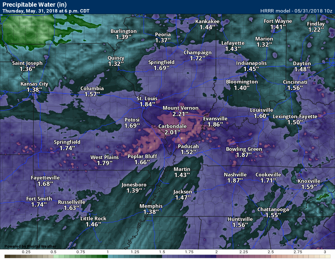
Flash flooding is a concern with high PWAT (moisture) levels. PWAT values will top 1.7″ today. Very high numbers. Slow moving storms could produce extremely heavy downpours. Avoid flooded roadways.

Interactive Radars:
Interactive live weather radar page. Choose the city nearest your location. If one of the city radars won’t load then try a nearby one. Click here.

Questions? Broken links? Other?
You may email me at beaudodson@usawx.com

Thursday through Saturday: Severe storms are likely today. This is an area-wide risk. Large hail and damaging wind is the main concern. Frequent lightning and torrential downpours, as well. There is a low end risk of tornadoes.
A severe thunderstorm or tornado watch is likely to be issued later today.
Thunderstorms are likely this evening, as well. Some of the storms could be severe.
Flash flooding is also a concern later today and tonight.
A few storms are possible Friday and Friday night. Most of the storms will remain below severe levels. I can’t rule out a storm becoming severe, but widespread severe weather is unlikely.
We have another risk of thunderstorms Saturday and Saturday night. Some of these storms could be intense with hail and high winds. Monitor updates concerning the weekend threat of severe thunderstorms.
.
![]()
Interactive live weather radar page. Choose the city nearest your location. If one of the cities does not work then try a nearby one. Click here.
National map of weather watches and warnings. Click here.
Storm Prediction Center. Click here.
Weather Prediction Center. Click here.

Live lightning data: Click here.

Interactive GOES R satellite. Track clouds. Click here.

Here are the latest local river stage forecast numbers Click Here.
Here are the latest lake stage forecast numbers for Kentucky Lake and Lake Barkley Click Here.

The spring and preliminary summer outlooks have been posted for subscribers. Scroll down to see the outlook.
Not a subscriber? Learn more at this link.

Weather Headlines
- Severe thunderstorms likely later today
- Heavy rain, frequent lightning, damaging wind, and hail will be possible. Low-end tornado risk.
- Warm and muggy conditions through Saturday.
- Somewhat cooler and less humid air arrives Sunday and Monday.
Monitor updates today. Remember, a watch means that conditions are favorable for severe storms. A warning means to seek shelter. A warning is more serious than a watch. A warning means severe weather is expected in or near your location.
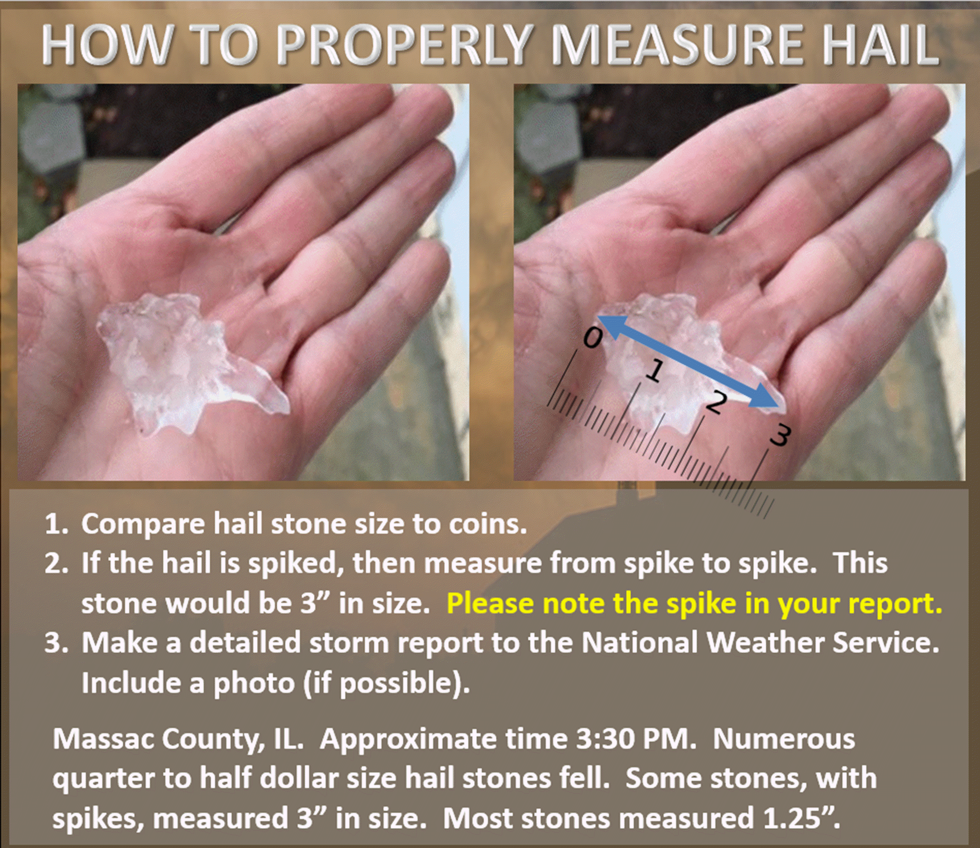
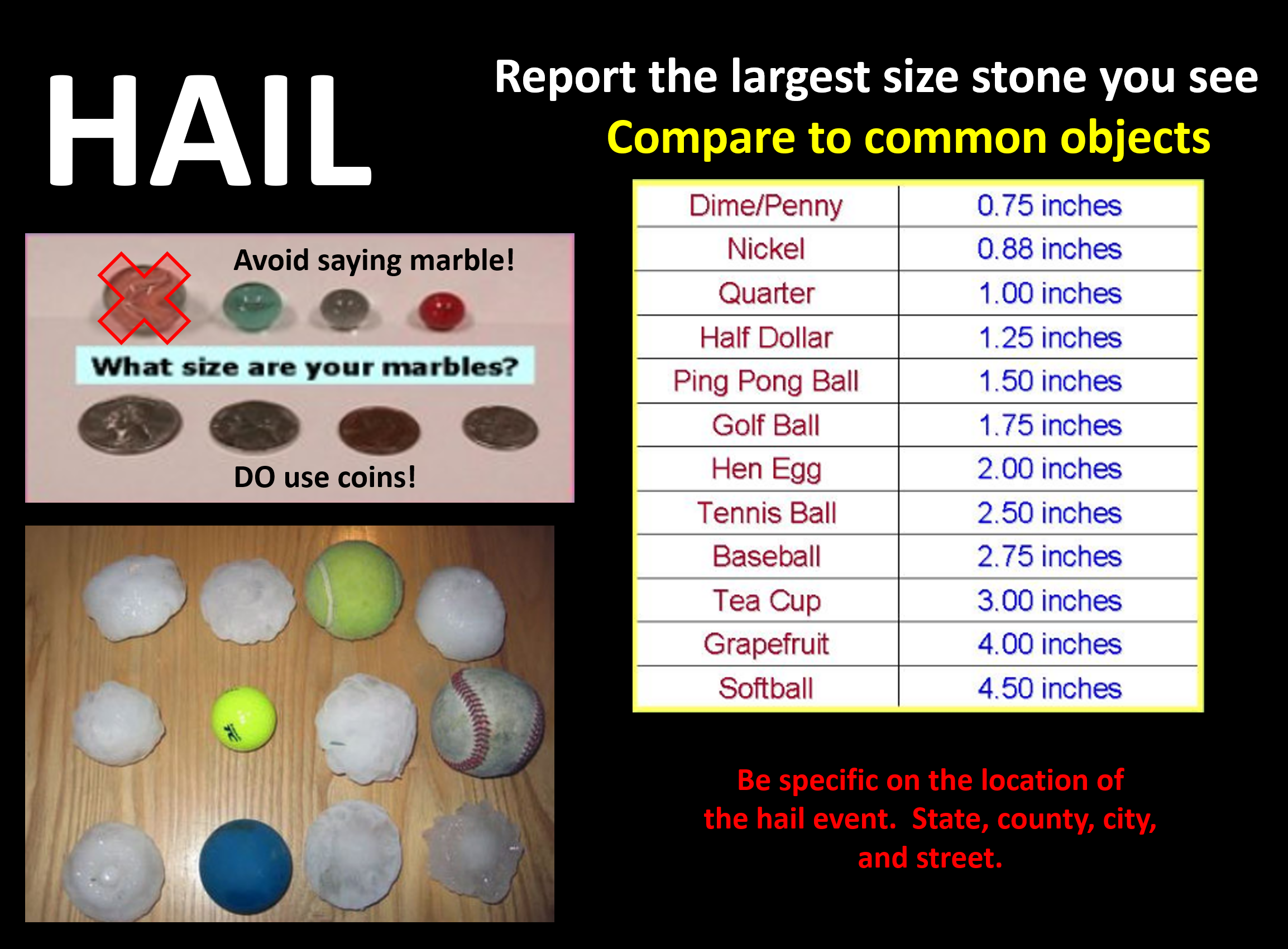
If you report hail please tell us the size (compared to coins). Also, let us know the time of the event, location (be specific).
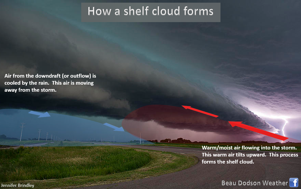
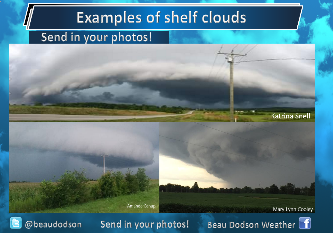
You might see some shelf clouds today. They can be quite spectacular.
The main weather story today will be the risk of severe thunderstorms with damaging wind, hail, and possibly flash flooding in some locations.
There remain some questions about how this all unfolds.
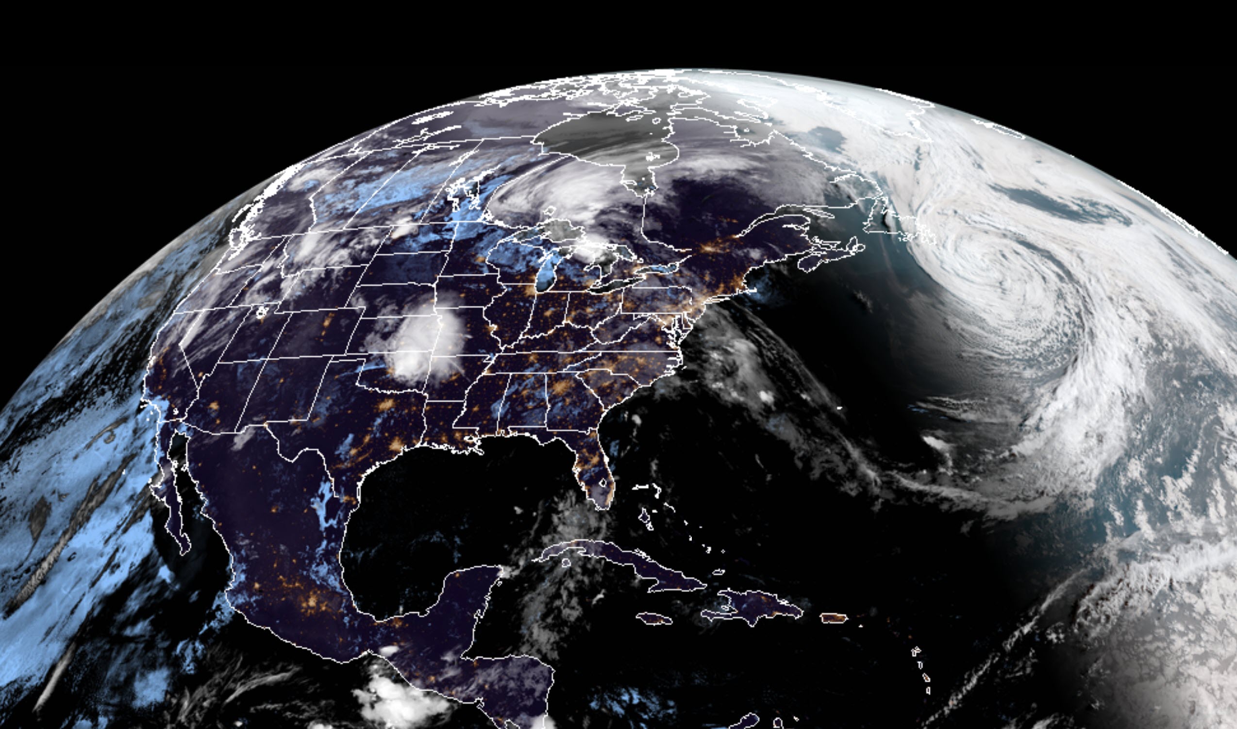
We have a thunderstorm complex approaching from Missouri. This complex of storms produced severe weather across Kansas and Oklahoma overnight. Numerous warnings were issued for damaging wind and even some tornadoes.
This morning, the line has weakened below severe levels (for the most part).
The atmosphere in our region will become increasingly unstable as we move through the morning hours.
A band of showers and thunderstorms will accompany the incoming MCS (complex of dying storms). The greatest coverage of morning storms may end up across northern portions of southeast Missouri and southern Illinois.
Some of these morning storms could produce hail and high winds.
The MCS (thunderstorm complex) will depart the region as we move into the late morning and afternoon hours.
There are plenty of clouds associated with this feature.
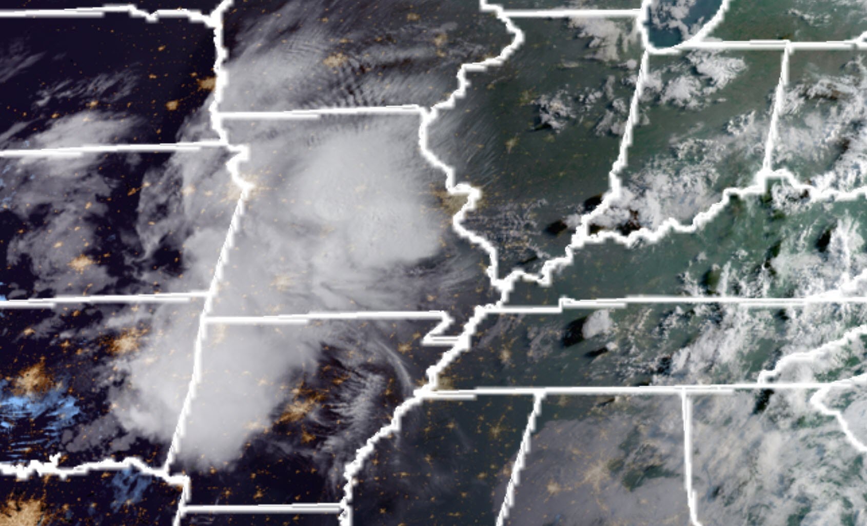
Let’s take a look at GOES 16 this morning. On the zoomed out view you can clearly see the MCS. Large round white area in the Central United States. Pretty cool view!
Visible view
IR view
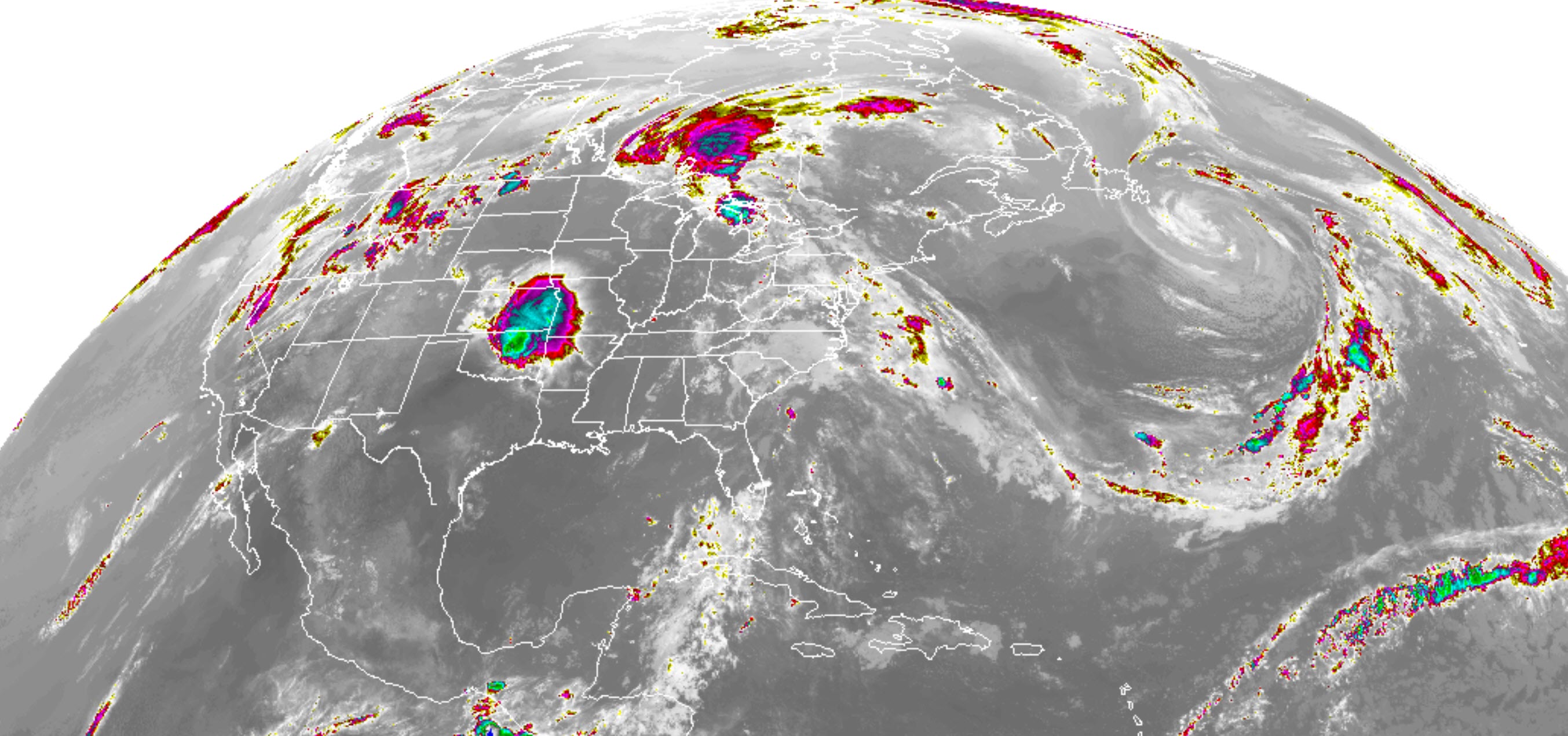
Zoomed in view below
The big question is how much do we destabilize as we move through the afternoon hours.
If the atmosphere can recover then we will see another round of heavy thunderstorms this afternoon into tonight.
This second round of thunderstorms is the reason the Storm Prediction Center has placed our region in an enhanced (level 3 out of 5) risk. One is the lowest risk and five is the greatest risk.
The main concern will be damaging wind and hail. I can’t rule out tornado warnings. The tornado risk is low, but not zero.
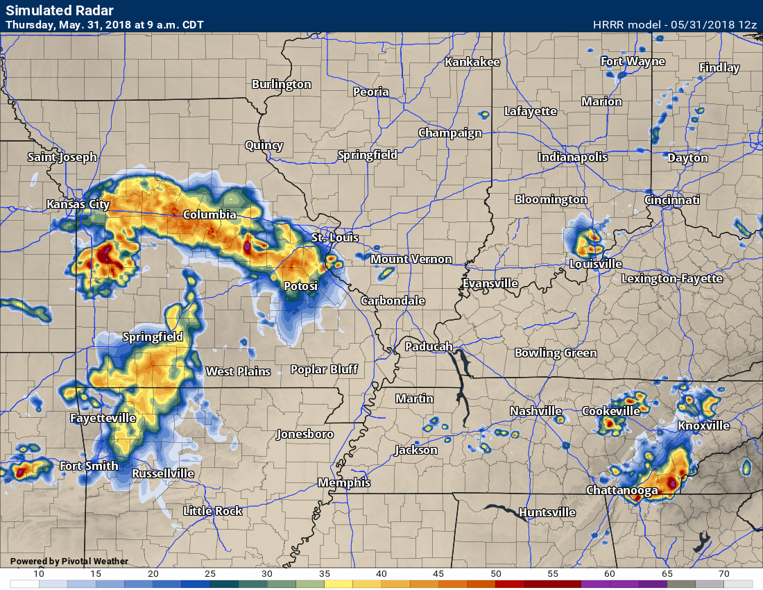
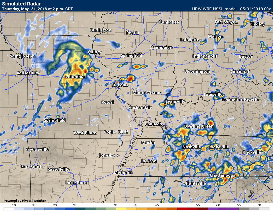
Let’s take a look at the Hrrr model guidance future-cast radar. Keep in mind, this is a model’s opinion on how this all unfolds. There are different model solutions for this event.
You can see the first band of storms move through during the morning hours. Then, a second band of storms forms this afternoon. Notice the direction of movement. There are some indications of bowing line segments. Bowing storms can produce damaging winds and even brief tornadoes.
Monitor watches and warnings today.
I will be sending out text/app messages. Try and download the app. The app receives the text messages faster.
Again, this is a model’s opinion.
Here is another model’s opinion.
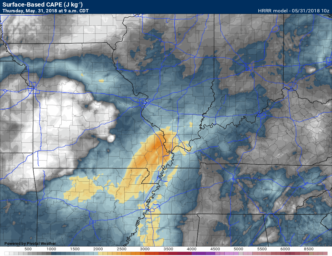
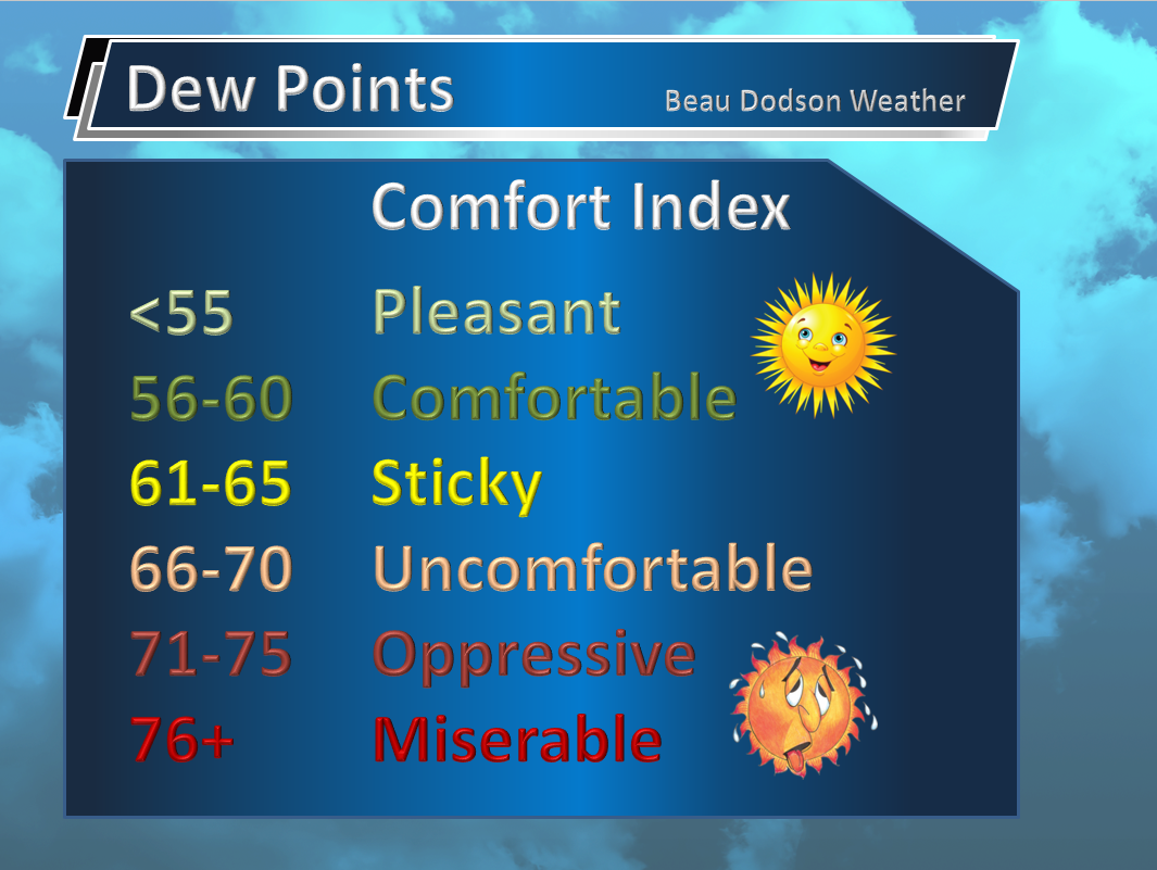
CAPE values are forecast to pop into the 2000 to 4000 range later today. That is a lot of energy. CAPE is a measure of instability/energy for storms to tap into. Numbers above 2000 are considered high. CAPE normally depends on how much sunshine we have during the day (more sun equals warmer temperatures). There are other factors that cause CAPE to rise. Dew point being one of them. Dew points today will also be high.
Here is the CAPE animation for today into this evening.
Notice how the near zero CAPE zone develops (white areas). That is where storms move through and basically eat he CAPE (use the CAPE). Storms feed off of CAPE. Once storms move over an area then CAPE decreases.
PWAT values will be very high today. Near the top of the charts. Some of the guidance indicates 2″ PWAT values. Ton of moisture in the atmosphere to work with. Thunderstorms will be prolific rain producers.
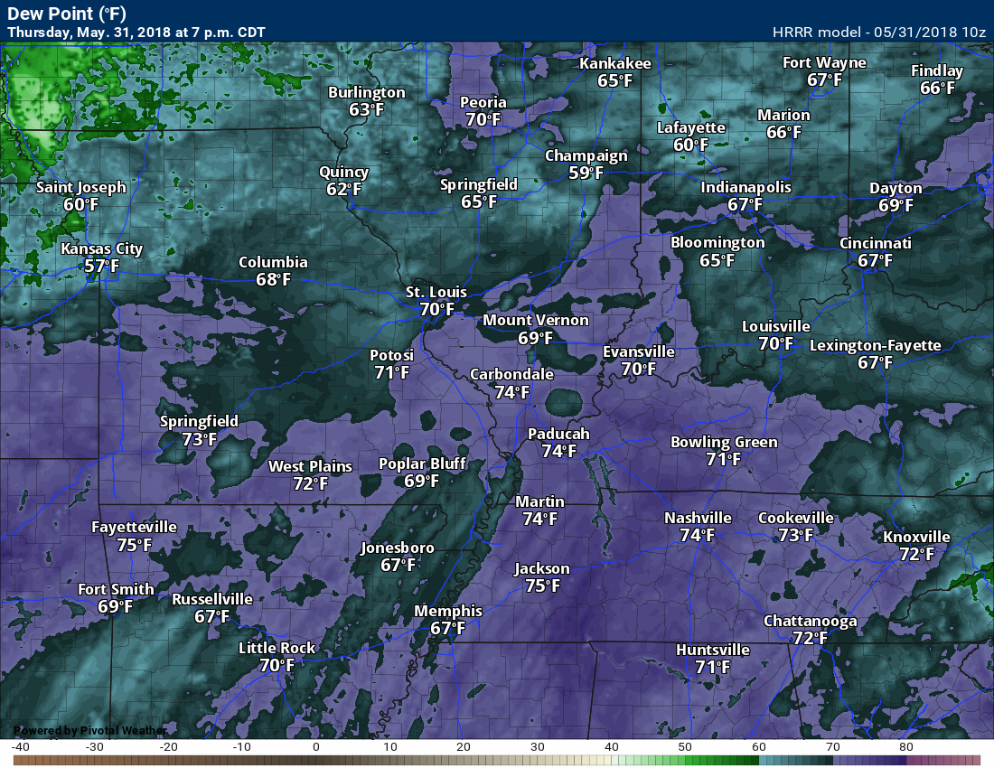
Dew points will also be high. Dew point is a measure of moisture in the lower atmosphere. This is a better measurement than humidity. These are ick numbers.
Friday will be warm and muggy with a few scattered storms.
There will be another chance of severe weather Saturday and Saturday night. This second event might be skewed a bit more to the west. Monitor updates. Damaging wind and hail are the main concern.

A new weather podcast is now available! Weather Geeks (which you might remember is on The Weather Channel each Sunday)
To learn more visit their website. Click here.
.![]()

WeatherBrains Episode 645
The first named storm of 2018 is now in the books, so we’re going to be talking with two experts in the area of tropical weather, Max Mayfield, left, and Bryan Norcross, right.
These two hurricane specialists currently work for WPLG in Fort Lauderdale. They both need no introduction. Max Mayfield, former Director of the National Hurricane Center, and Bryan Norcross, Mr. Hurricane who appeared on the show a few months ago when his book came out.
Max was unable to get connected to the hangout.
Other discussions in this weekly podcast include topics like:
- Extremes: 111 at Death Valley, CA, and 28 at Leadville, CO
- Alberto developed in SE Gulf and moved north through Alabama
- Humongous flooding in Ellicott City, MD
- 4 lightning deaths in US this year
- Astronomy Outlook with Tony Rice
- and more!
Previous episodes can be viewed by clicking here.

We offer interactive local city live radars and regional radars. If a radar does not update then try another one. If a radar does not appear to be refreshing then hit Ctrl F5. You may also try restarting your browser.
The local city view radars also have clickable warnings.
During the winter months, you can track snow and ice by clicking the winterize button on the local city view interactive radars.
You may email me at beaudodson@usawx.com
Find me on Facebook!

Find me on Twitter!

Did you know that a portion of your monthly subscription helps support local charity projects?
You can learn more about those projects by visiting the Shadow Angel Foundation website and the Beau Dodson News website.

I encourae subscribers to use the app vs regular text messaging. We have found text messaging to be delayed during severe weather. The app typically will receive the messages instantly. I recommend people have three to four methods of receiving their severe weather information.
Remember, my app and text alerts are hand typed and not computer generated. You are being given personal attention during significant weather events.
