.
Click one of the links below to take you directly to that section.
Do you have any suggestions or comments? Email me at beaudodson@usawx.com
.
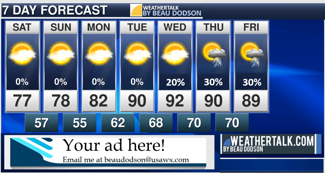
7-day forecast for southeast Missouri, southern Illinois, western Kentucky, and western Tennessee.
This is a blend for the region. See the detailed region by region forecast further down in this post.
.


.
.

.
Friday through Friday
1. Is lightning in the forecast? Yes. A chance of lightning today. I will be monitoring a NW to SE moving system Monday. I will monitor next Wednesday night and Thursday/Friday.
2. Are severe thunderstorms in the forecast? Not at this time. I will be monitoring next Wednesday night into Thursday/Friday.
* The NWS officially defines a severe thunderstorm as a storm with 58 mph wind or greater, 1″ hail or larger, and/or tornadoes
3. Is flash flooding in the forecast? Not at this time.
4. Will there be a chance of a frost or freeze? No.
5. Will the heat index exceed 100 degrees? No.
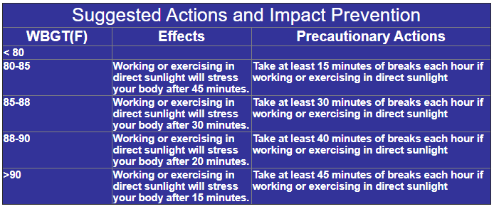
6. Will the wet-bulb globe temperature reach danger levels? No. WBFT forecast below.
Friday WBGT (F): 73° No issues.
Saturday WBGT (F): 70° Nice feel to the air.
Sunday WBGT (F): 70° Nice feel to the air.
Monday WBGT (F): 74° No issues.
Tuesday WBGT (F): 74° No issues.
Wednesday WBGT (F): 76° No issues.
Thursday WBGT (F): 80° No issues.
Friday WBGT (F): 83° Marginal. If working outside, then take 15-minute breaks each hour.
.
The WetBulb Globe Temperature (WBGT) is a measure of the heat stress in direct sunlight, which takes into account: temperature, humidity, wind speed, sun angle and cloud cover (solar radiation).
This differs from the heat index, which takes into consideration temperature and humidity and is calculated for shady areas.
If you work or exercise in direct sunlight, this is a good element to monitor.
Sports coaches, schools, military agencies, OSHA, and many nations use the WBGT as a guide to managing workload in direct sunlight.

Something wrong on the page? Suggestions? Email me at beaudodson@usawx.com
.
..
.
May 29, 2020
How confident am I that this days forecast will verify? High confidence
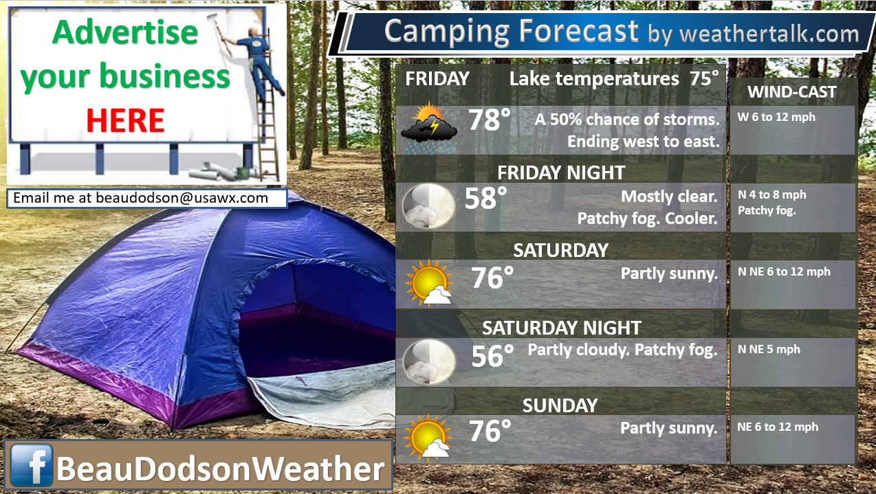
Friday Forecast: Partly sunny. a cold front will sweep eastward and usher in less humid air. Cooler air. A few showers and thunderstorms will develop along and ahead of the front. Mainly over southeast Illinois and western Kentucky.
What is the chance of precipitation? MO ~ 20% IL ~ 40% KY ~ 50% TN ~ 30%
Temperature range: MO Bootheel 77° to 80° SE MO 75° to 78° South IL 75° to 80° Northwest KY (near Indiana border) 75° to 80° West KY 78° to 80° NW TN 78° to 80°
Wind direction and speed: West becoming north and northwest at 5 to 10 mph
Wind chill or heat index (feels like) temperature forecast: 75° to 82°
Coverage of precipitation: Scattered (mainly southeast Illinois and Kentucky).
What impacts are anticipated from the weather? Wet roadways. Lightning.
Should I cancel my outdoor plans? I would not cancel any plans. I would monitor radars. There will be some showers and thunderstorms to deal with.
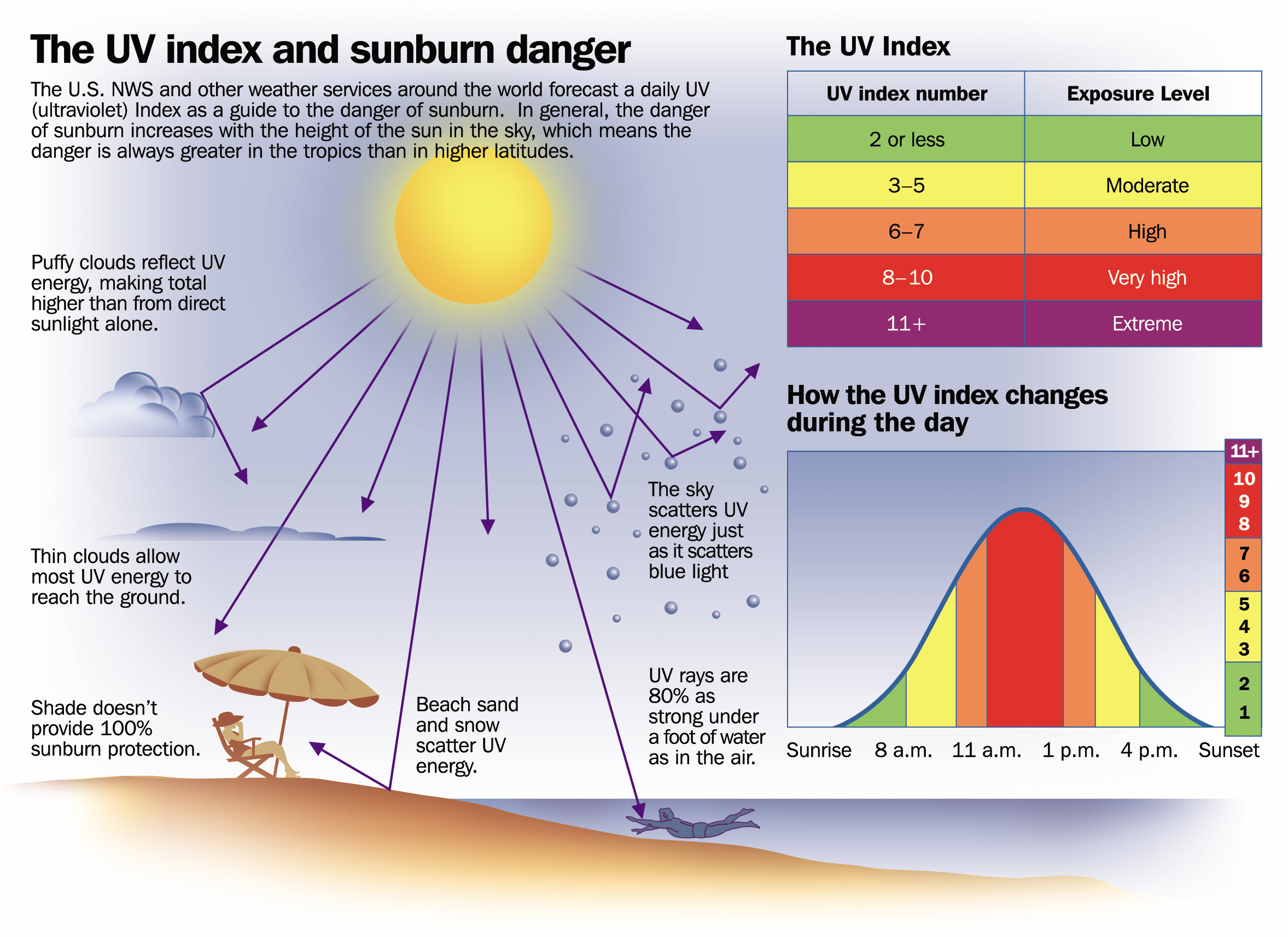
UV Index: 9. Very high.
Sunrise: 5:37 AM
Sunset: 8:09 PM
.
Friday night Forecast: Clearing. Turning cooler. Patchy fog possible after midnight.
What is the chance of precipitation? MO ~ 0% IL ~ 0% KY ~ 0% TN ~ 0%
Temperature range: MO Bootheel 52° to 55° SE MO 52° to 55° South IL 52° to 55° Northwest KY (near Indiana border) 54° to 56° West KY 54° to 56° NW TN 54° to 56°
Wind direction and speed: North at 5 to 10 mph
Wind chill or heat index (feels like) temperature forecast: 52° to 55°
Coverage of precipitation: None
What impacts are anticipated from the weather? Lower visibility if fog forms.
Should I cancel my outdoor plans? No.
Moonrise: 12:06 PM
Moonset: 1:21 AM
The phase of the moon: First Quarter
.
May 30, 2020
How confident am I that this days forecast will verify? High confidence
Saturday Forecast: Mostly sunny AM. A few PM clouds. Cooler. Pleasant temperatures.
What is the chance of precipitation? MO ~ 0% IL ~ 0% KY ~ 0% TN ~ 0%
Temperature range: MO Bootheel 73° to 76° SE MO 73° to 76° South IL 73° to 76° Northwest KY (near Indiana border) 74° to 76° West KY 74° to 76° NW TN 74° to 76°
Wind direction and speed: North at 6 to 12 mph with gusts to 15 mph.
Wind chill or heat index (feels like) temperature forecast: 72° to 75°
Coverage of precipitation: None
What impacts are anticipated from the weather? None
Should I cancel my outdoor plans? No
UV Index: 9. Very high.
Sunrise: 5:36 AM
Sunset: 8:10 PM
.
Saturday night Forecast: Increasing clouds from the northwest. Pleasant temperatures. Perhaps some late night fog.
What is the chance of precipitation? MO ~ 0% IL ~ 0% KY ~ 0% TN ~ 0%
Temperature range: MO Bootheel 54° to 58° SE MO 53° to 56° South IL 53° to 56° Northwest KY (near Indiana border) 52° to 55° West KY 54° to 58° NW TN 54° to 58°
Wind direction and speed: North at 5 mph
Wind chill or heat index (feels like) temperature forecast: 52° to 55°
Coverage of precipitation: None
What impacts are anticipated from the weather? Lower visibility in areas of fog.
Should I cancel my outdoor plans? No
Moonrise: 1:15 PM
Moonset: 1:57 AM
The phase of the moon: Waxing Gibbous
.
May 31, 2020
How confident am I that this days forecast will verify? High confidence
Sunday Forecast: A mix of sun and clouds. A fast-moving NW to SE Moving system will likely bring some clouds. Pleasant temperatures.
What is the chance of precipitation? MO ~ 0% IL ~ 0% KY ~ 0% TN ~ 0%
Temperature range: MO Bootheel 74° to 78° SE MO 74° to 76° South IL 74° to 76° Northwest KY (near Indiana border) 73° to 75° West KY 74° to 76° NW TN 74° to 76°
Wind direction and speed: Light wind from the north and northeast at 5 mph.
Wind chill or heat index (feels like) temperature forecast: 72° to 76°
Coverage of precipitation: None
What impacts are anticipated from the weather? None
Should I cancel my outdoor plans? No.
UV Index: 10. Very high.
Sunrise: 5:36 AM
Sunset: 8:10 PM
.
Sunday night Forecast: Mostly clear. Patchy fog forming. Pleasant temperatures.
What is the chance of precipitation? MO ~ 0% IL ~ 0% KY ~ 0% TN ~ 0%
Temperature range: MO Bootheel 54° to 56° SE MO 52° to 55° South IL 52° to 55° Northwest KY (near Indiana border) 52° to 55° West KY 53° to 56° NW TN 54° to 58°
Wind direction and speed: East and northeast wind at 4 to 8 mph.
Wind chill or heat index (feels like) temperature forecast: 50° to 55°
Coverage of precipitation: None
What impacts are anticipated from the weather? Lower visibility if fog forms.
Should I cancel my outdoor plans? No
Moonrise: 2:25 PM
Moonset: 2:30 AM
The phase of the moon: Waxing Gibbous
.
June 1, 2020
How confident am I that this days forecast will verify? LOW confidence
Monday Forecast: Partly sunny. Mild. I am watching another NW to SE moving system that comes out of Iowa. For now, the chance of rain and storms appears low. This will need to be monitored.
What is the chance of precipitation? MO ~ 20% IL ~ 20% KY ~ 20% TN ~ 20%
Temperature range: MO Bootheel 80° to 82° SE MO 76° to 80° South IL 76° to 80° Northwest KY (near Indiana border) 76° to 80° West KY 78° to 82° NW TN 78° to 82°
Wind direction and speed: East/southeast at 5 mph.
Wind chill or heat index (feels like) temperature forecast: 75° to 80°
Coverage of precipitation: Monitor
What impacts are anticipated from the weather? Monitor
Should I cancel my outdoor plans? No.
UV Index: 10. Very high.
Sunrise: 5:35 AM
Sunset: 8:11 PM
.
Monday night Forecast: Partly cloudy. Patchy fog.
What is the chance of precipitation? MO ~ 0% IL ~ 0% KY ~ 0% TN ~ 0%
Temperature range: MO Bootheel 58° to 62° SE MO 58° to 62° South IL 58° to 62° Northwest KY (near Indiana border) 58° to 62° West KY 58° to 62° NW TN 58° to 62°
Wind direction and speed: Southeast at 4 to 8 mph
Wind chill or heat index (feels like) temperature forecast: 58° to 62°
Coverage of precipitation: None
What impacts are anticipated from the weather? Lower visibility if fog forms.
Should I cancel my outdoor plans? No
Moonrise: 3:34 PM
Moonset: 3:02 AM
The phase of the moon: Waxing Gibbous
.
June 2, 2020
How confident am I that this days forecast will verify? High confidence
Tuesday Forecast: Mostly sunny. Much warmer. A bit more humid.
What is the chance of precipitation? MO ~ 0% IL ~ 0% KY ~ 0% TN ~ 0%
Temperature range: MO Bootheel 86° to 88° SE MO 86° to 88° South IL 85° to 88° Northwest KY (near Indiana border) 85° to 88° West KY 85° to 88° NW TN 86° to 88°
Wind direction and speed: South and southwest wind 5 to 10 mph with gusts to 15 mph.
Wind chill or heat index (feels like) temperature forecast: 86° to 90°
Coverage of precipitation: None
What impacts are anticipated from the weather? None
Should I cancel my outdoor plans? No.
UV Index: 10. Very high.
Sunrise: 5:35 AM
Sunset: 8:12 PM
.
Tuesday night Forecast: Mostly clear. Patchy fog. Warmer. More humid.
What is the chance of precipitation? MO ~ 0% IL ~ 0% KY ~ 0% TN ~ 0%
Temperature range: MO Bootheel 66° to 68° SE MO 64° to 68° South IL 64° to 68° Northwest KY (near Indiana border) 64° to 66° West KY 66° to 68° NW TN 66° to 70°
Wind direction and speed: South and southwest at 4 to 8 mph.
Wind chill or heat index (feels like) temperature forecast: 64° to 70°
Coverage of precipitation: None
What impacts are anticipated from the weather? Lower visibility if fog forms.
Should I cancel my outdoor plans? No
Moonrise: 4:46 PM
Moonset: 3:33 AM
The phase of the moon: Waxing Gibbous
.
June 3, 2020
How confident am I that this days forecast will verify? Medium confidence
Wednesday Forecast: Mostly sunny AM. Partly cloudy during the afternoon. Warmer. More humid.
What is the chance of precipitation? MO ~ 0% IL ~ 0% KY ~ 0% TN ~ 0%
Temperature range: MO Bootheel 86° to 88° SE MO 86° to 88° South IL 85° to 88° Northwest KY (near Indiana border) 84° to 86° West KY 86° to 88° NW TN 88° to 90°
Wind direction and speed: Southwest at 5 to 10 mph.
Wind chill or heat index (feels like) temperature forecast: 86° to 92°
Coverage of precipitation: None
What impacts are anticipated from the weather? None
Should I cancel my outdoor plans? No
UV Index: 10. Very high.
Sunrise: 5:34 AM
Sunset: 8:13 PM
.
Wednesday night Forecast: Partly cloudy. A slight chance of thunderstorms.
What is the chance of precipitation? MO ~ 20% IL ~ 20% KY ~ 20% TN ~ 20%
Temperature range: MO Bootheel 68° to 72° SE MO 66° to 72° South IL 68° to 72° Northwest KY (near Indiana border) 68° to 72° West KY 68° to 72° NW TN 70° to 72°
Wind direction and speed: Southwest at 5 mph.
Wind chill or heat index (feels like) temperature forecast: 67° to 70°
Coverage of precipitation: Scattered
What impacts are anticipated from the weather? Wet roadways. Lightning.
Should I cancel my outdoor plans? No, but monitor.
Moonrise: 7:11 PM
Moonset: 4:45 AM
The phase of the moon: Waxing Gibbous
.
June 4, 2020
How confident am I that this days forecast will verify? LOW confidence
Thursday Forecast: Mostly sunny. Warm. A slight chance of thunderstorms.
What is the chance of precipitation? MO ~ 20% IL ~ 20% KY ~ 20% TN ~ 20%
Temperature range: MO Bootheel 86° to 90° SE MO 88° to 90° South IL 88° to 90° Northwest KY (near Indiana border) 86° to 90° West KY 88° to 92° NW TN 88° to 92°
Wind direction and speed: Southwest at 5 to 10 mph.
Wind chill or heat index (feels like) temperature forecast: 88° to 94°
Coverage of precipitation: Widely scattered
What impacts are anticipated from the weather? Wet roadways. Lightning.
Should I cancel my outdoor plans? No, but monitor updates.
UV Index: 10. Very high.
Sunrise: 5:34 AM
Sunset: 8:13 PM
.
Thursday night Forecast: Partly cloudy. A slight chance of thunderstorms.
What is the chance of precipitation? MO ~ 20% IL ~ 20% KY ~ 20% TN ~ 20%
Temperature range: MO Bootheel 68° to 72° SE MO 66° to 72° South IL 68° to 72° Northwest KY (near Indiana border) 68° to 72° West KY 68° to 72° NW TN 70° to 72°
Wind direction and speed: South at 5 mph.
Wind chill or heat index (feels like) temperature forecast: 68° to 72°
Coverage of precipitation: Widely scattered
What impacts are anticipated from the weather? Wet roadways. Lightning.
Should I cancel my outdoor plans? No, but monitor updates.
Moonrise: 7:11 PM
Moonset: 4:45 AM
The phase of the moon: Waxing Gibbous
.
June 5, 2020
How confident am I that this days forecast will verify? LOW confidence
Friday Forecast: Partly sunny. Warm.
What is the chance of precipitation? MO ~ 0% IL ~ 0% KY ~ 0% TN ~ 0%
Temperature range: MO Bootheel 86° to 90° SE MO 88° to 90° South IL 88° to 90° Northwest KY (near Indiana border) 86° to 90° West KY 88° to 92° NW TN 88° to 92°
Wind direction and speed: Southwest at 5 mph.
Wind chill or heat index (feels like) temperature forecast: 88° to 94°
Coverage of precipitation: None
What impacts are anticipated from the weather? None
Should I cancel my outdoor plans? No
UV Index: 10. Very high.
Sunrise: 5:34 AM
Sunset: 8:13 PM
.
Friday night Forecast: Partly cloudy. Becoming mostly clear.
What is the chance of precipitation? MO ~ 0% IL ~ 0% KY ~ 0% TN ~ 0%
Temperature range: MO Bootheel 68° to 72° SE MO 66° to 72° South IL 68° to 72° Northwest KY (near Indiana border) 68° to 72° West KY 68° to 72° NW TN 70° to 72°
Wind direction and speed: Southwest at 5 mph.
Wind chill or heat index (feels like) temperature forecast: 68° to 72°
Coverage of precipitation: None
What impacts are anticipated from the weather? None
Should I cancel my outdoor plans? No
Moonrise: 8:22 PM
Moonset: 5:27 AM
The phase of the moon: Full
What is the UV index?
.

.
- Once again, some fields will be wet.
- A few showers/storms today.
- Drier Friday night into Wednesday.
- Heat stress may become an issue towards the middle and end of next week.
.
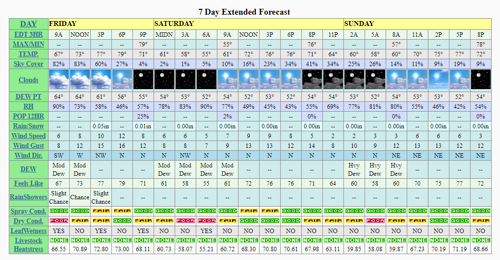
Click to enlarge the graphics.
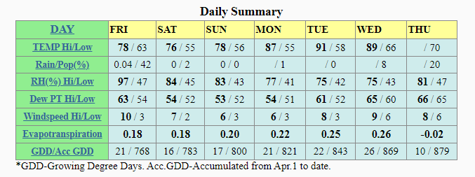
Remember, this is an average across our local area. The county by county will vary. See the detailed forecast above for each area.
.
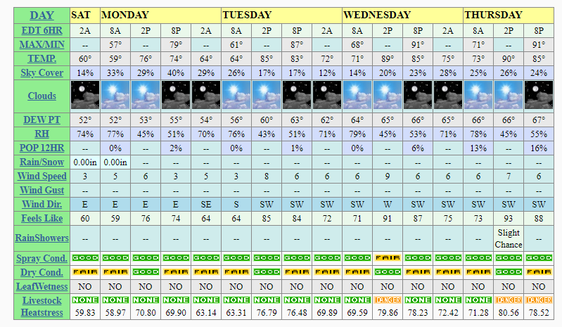
Click graphics to enlarge them.
.
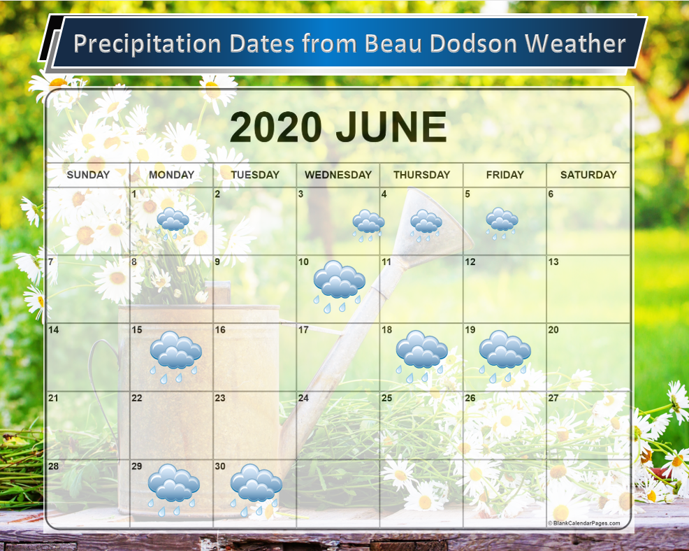
These are dates that may have precipitation. Monitor the trends in the forecast.
Anything past day seven is low confidence.

![]()
![]()
Graphic-cast
Click here if you would like to return to the top of the page.
Illinois
During active weather check my handwritten forecast towards the top of the page.

.
Kentucky
During active weather check my handwritten forecast towards the top of the page.


.
Tennessee
During active weather check my handwritten forecast towards the top of the page.

.
Today through June 5th. A few thunderstorms are possible today. Lightning is the main concern. Perhaps gusty winds near the thunderstorms. Move indoors until the thunderstorms pass.
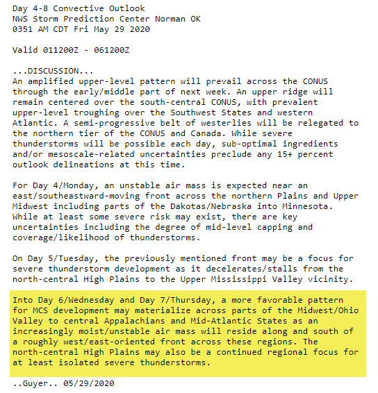
I am monitoring Monday. A system moving NW to SE across the Ohio Valley could deliver a few thunderstorms. Low confidence.
In the long-range, I will be monitoring the track of thunderstorm complexes next Thursday, Friday, Saturday, and Sunday. For now, the track is uncertain. Thus, no severe thunderstorms are currently in our forecast. Monitor updates.
.
Today’s outlook (below).
Light green is where thunderstorms may occur but should be below severe levels.
Dark green is a level one risk. Yellow is a level two risk. Orange is a level three (enhanced) risk. Red is a level four (moderate) risk. Pink is a level five (high) risk.
One is the lowest risk. Five is the highest risk.
A severe storm is one that produces 58 mph wind or higher, quarter size hail, and/or a tornado.
The tan states are simply a region that SPC outlined on this particular map. Just ignore that.

The black outline is our local area.

.
Tomorrow’s severe weather outlook.

.

.
The images below are from the WPC. Their totals are a bit lower than our current forecast. I wanted to show you the comparison.
24-hour precipitation outlook.
.
 .
.
48-hour precipitation outlook.
.
.
72-hour precipitation outlook.
.
![]()

![]()
..
Weather advice:
Updated May 29, 2020
A few thunderstorms are possible today. Lightning will be the main concern. Perhaps some gusty wind near storms.
A heat ridge is forecast to develop mid to late next week. Hot and increasingly humid air. We will likely have to start thinking about heat index values above 90 Thursday or Friday onward.
Download the Beau Dodson Weather Talk app from the app store. Search for Weather Talk by the Fire Horn. Download it. Install it. It is for subscribers. Not a subscriber? Go to www.weathertalk.com/welcome
.
Weather Discussion
-
- A cold front sweeps eastward today!
- A few showers and thunderstorms are possible as it moves across the region.
- A cold front arrives tonight and Friday. This will bring an end to our warm, humid, and unstable airmass.
- MUCH nicer this weekend. Perhaps some clouds lingering.
- A ridge of high pressure builds in next week. Where it is centered will determine our high temperatures. Hot weather by mid/late week? Monitoring.
- Monitoring thunderstorm clusters next week.
I have been talking about this front all week long. Here it comes! Two fronts. They are both going to push across the entire area today.
We will have some scattered showers and thunderstorms today. It does not appear to be a widespread concern.
The precipitation will occur along and ahead of the cold front. Chances will be a bit higher over southeast Illinois and Kentucky. Lower rain chances over southeast Missouri.
This will lower temperatures and dew points. It won’t feel muggy behind this front.
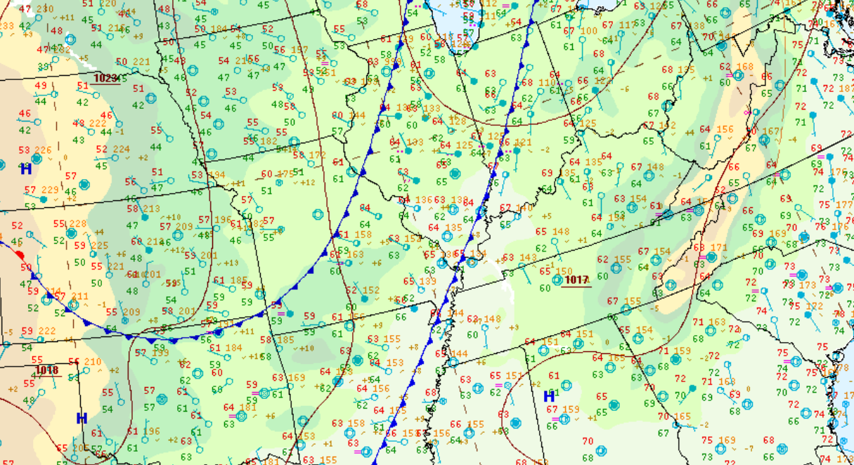
8 AM dew points. Muggy air in front of the front. Drier air behind the front. Dew points in the 60s feel humid. The middle to upper 60s feel muggy.

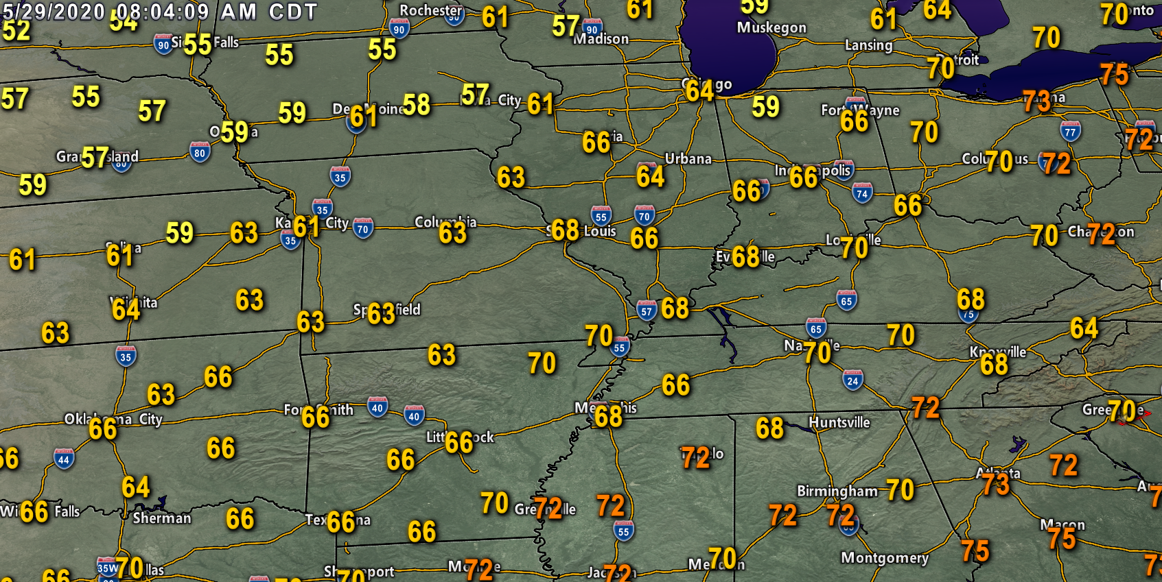
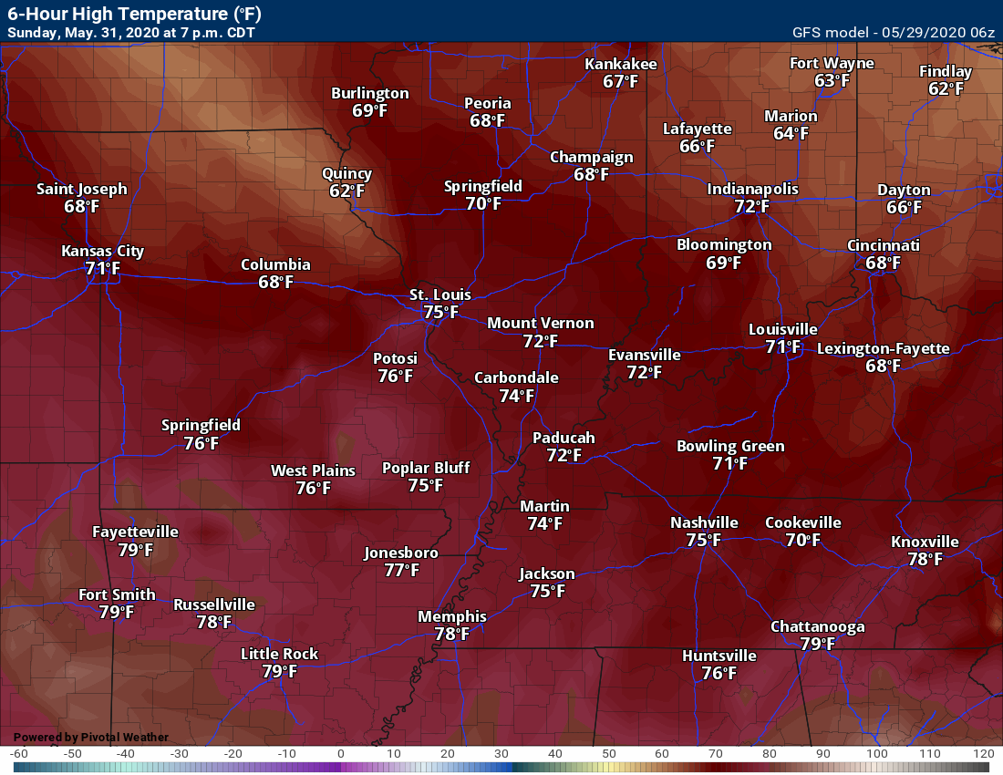
Here is the temperature map (8 AM). You can see cooler air in Kansas, Nebraska, and Iowa.
.
The weekend is going to feel completely different than the last few days. Highs in the 70s. Lows in the 50s. Dew points in the 50s. Spring weather!
The only fly in the ointment could be a few clouds. There is some disagreement on the amount of cloud cover. For now, I went partly cloudy through the period.
Patchy fog is also possible each night/morning.
Enjoy this weekend’s weather, because it is not going to last.
.
Is a heatwave developing? Stay tuned.
I will be monitoring thunderstorm clusters next week. There remain some questions about the track of these thunderstorms.
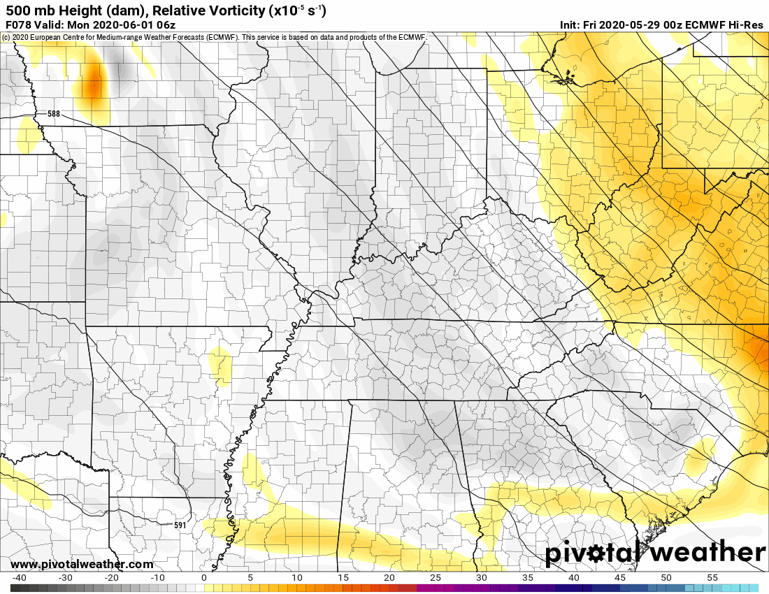
One system arrives Monday. It moves northwest to southeast across the Missouri and Ohio Valley.
Confidence in this bringing thunderstorms to our area is rather low. Monitor updates.
You can see that piece of energy here on the EC model.
.
A ridge of high pressure will build into the region next week.
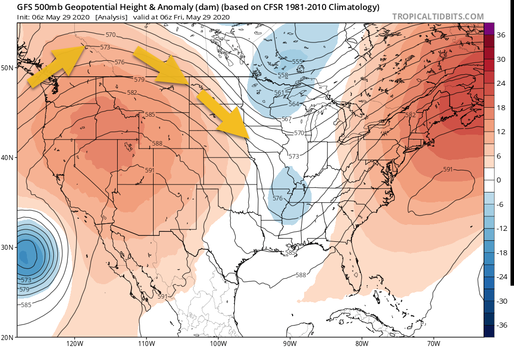
Let me show you the 500 mb anomaly plot. Temperature anomaly at 18,000′. This is one controlling feature of our weather.
Let me compare today’s map vs next week’s map.
We are currently in a trough.
The atmosphere is made up of troughs and ridges. Troughs tend to bring cloudy and wet weather conditions. Ridges tend to bring hotter and sunnier weather.
Low pressures are associated with troughs. High pressure is associated with ridges.
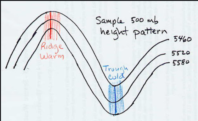
.
Notice how those black lines (height/temp) lines curve from NW to SE over our region? That is what today’s 500 mb look like. Winds will be out of the north and northwest. Cooler air. Nicer air. A trough in the east and a ridge in the west. It will be hot in the southwest U.S.
We are in a trough. Thus, the clouds and on/off precipitation.
.
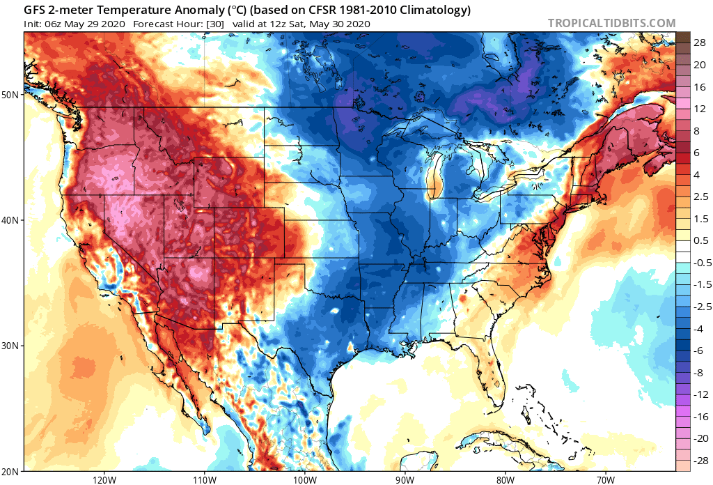
That correlates to below normal temperatures this weekend. You can see that on this temperature anomaly map. This shows above and below normal temperatures.
We are in blue this weekend. Below normal temperatures.
.
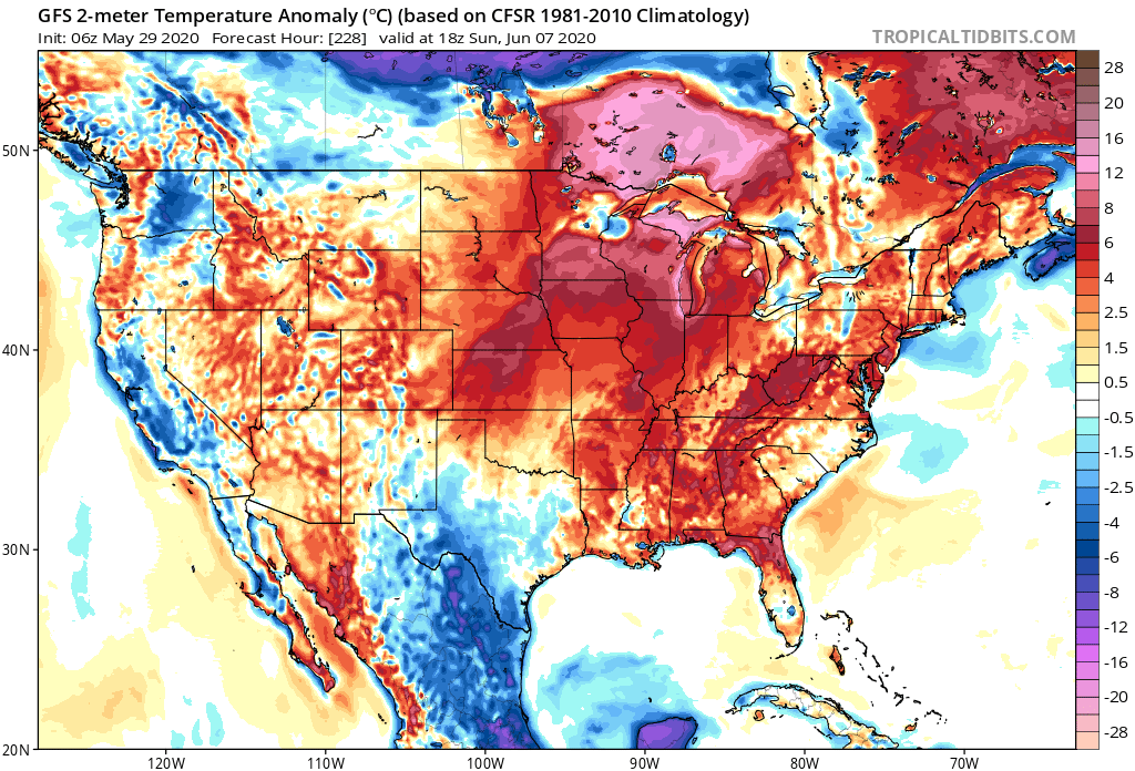
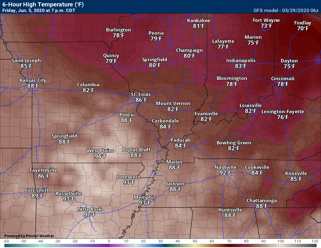
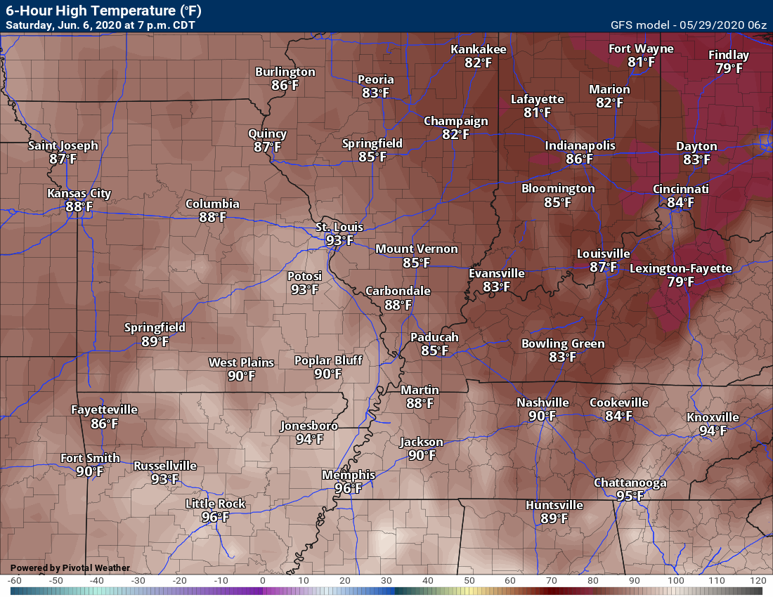
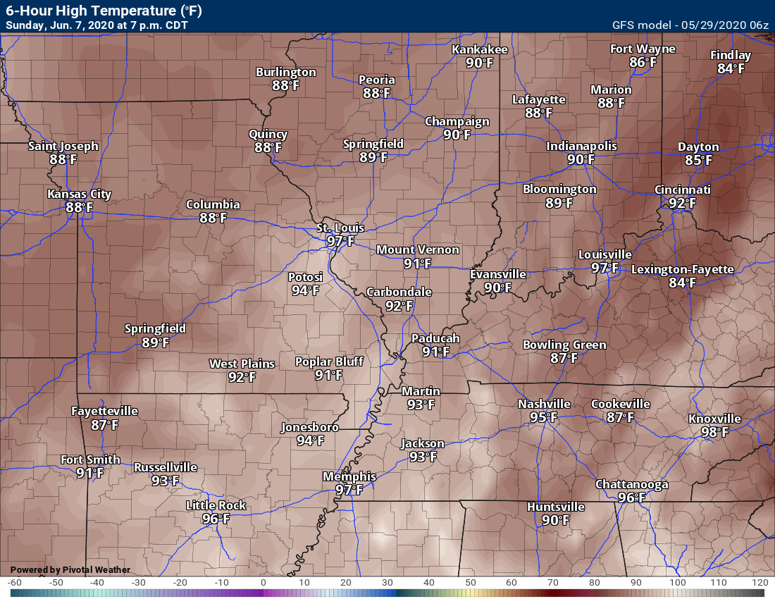
Compare that to next weekend. We call this a ridge. Heights build upward/higher. This spells hot air.
This is the GFS map. Temperatures in the 90s will be possible (if this verifies).

The EC model shows the same. Hot. Temperatures in the 90s will be possible if this verifies.

.
Now, let’s look at temperature anomalies next weekend. We are in the red next weekend. Above normal temperatures. The Mid to upper 80s appears likely.
.
.A heat dome is what some meteorologists call these late spring and summer ridges.
I continue to be concerned about drought this summer. I know it has been wet. That can change on a dime. As we know.
For now, we are looking at the upper 80s and perhaps 90s. It will come down to the strength of the ridge of high pressure and placement of its core.

.
Let’s compare temperatures.
This weekend (Sunday)
Next Friday’s
Saturday highs
Sunday
.
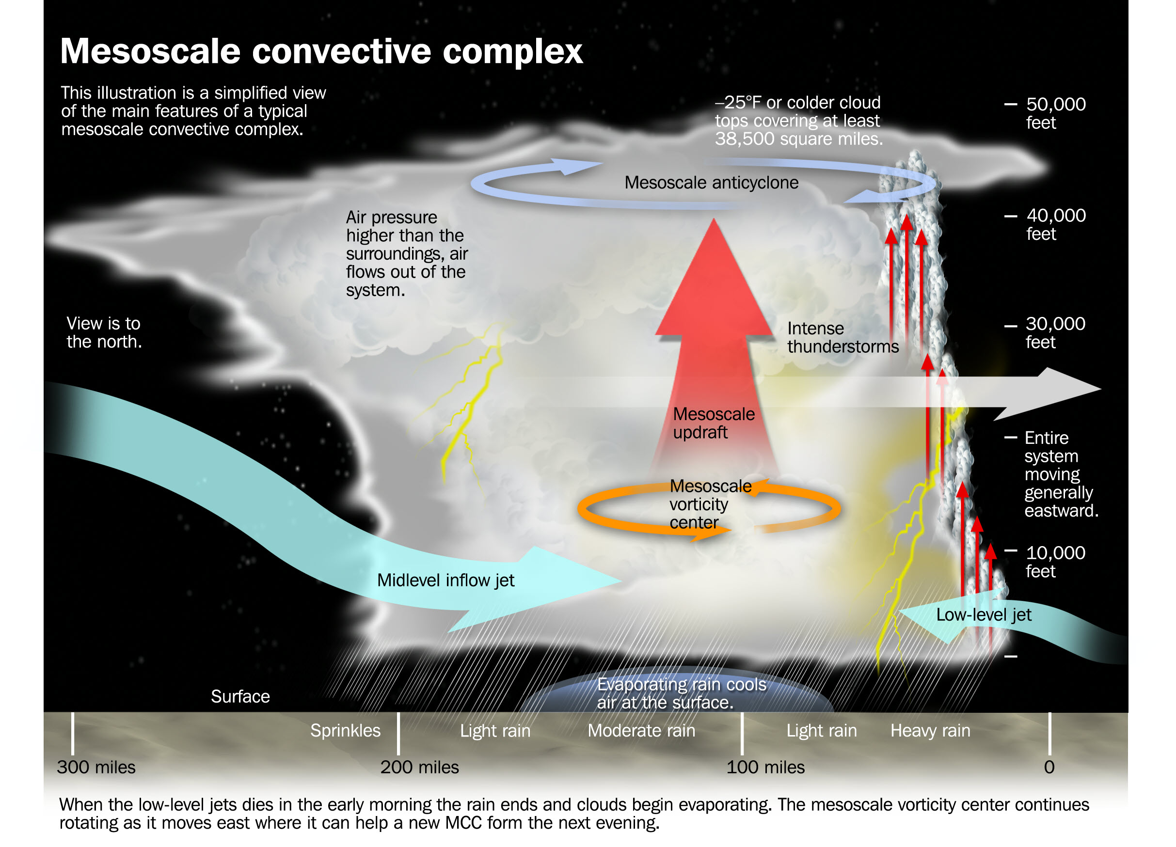
We will also have to monitor the chance of thunderstorm complexes that travel along the 588 line. Typically, these are large thunderstorm complexes. Mesoscale Convection Systems.

Click the graphic to enlarge it.
.
The Storm Prediction Center is already talking about the potential.
The placement will need to be ironed out.
![]()
.
 .
.
Click here if you would like to return to the top of the page.
Again, as a reminder, these are models. They are never 100% accurate. Take the general idea from them.
What should I take from these?
- The general idea and not specifics. Models usually do well with the generalities.
- The time-stamp is located in the upper left corner.
.
What am I looking at?
You are looking at different models. Meteorologists use many different models to forecast the weather. All models are wrong. Some are more wrong than others. Meteorologists have to make a forecast based on the guidance/models.
I show you these so you can see what the different models are showing as far as precipitation. If most of the models agree, then the confidence in the final weather forecast increases.
.
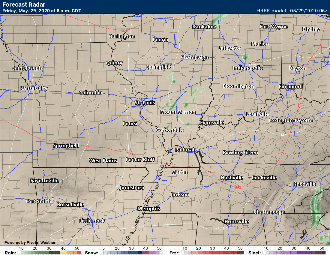
This animation is the Hrrr model.
This animation shows you what radar might look like as the next system pulls through the region. It is a future-cast radar.
Green is rain. Blue is snow. Pink and red represent sleet and freezing rain.
Time-stamp upper left. Click the animation to enlarge it.
.
.
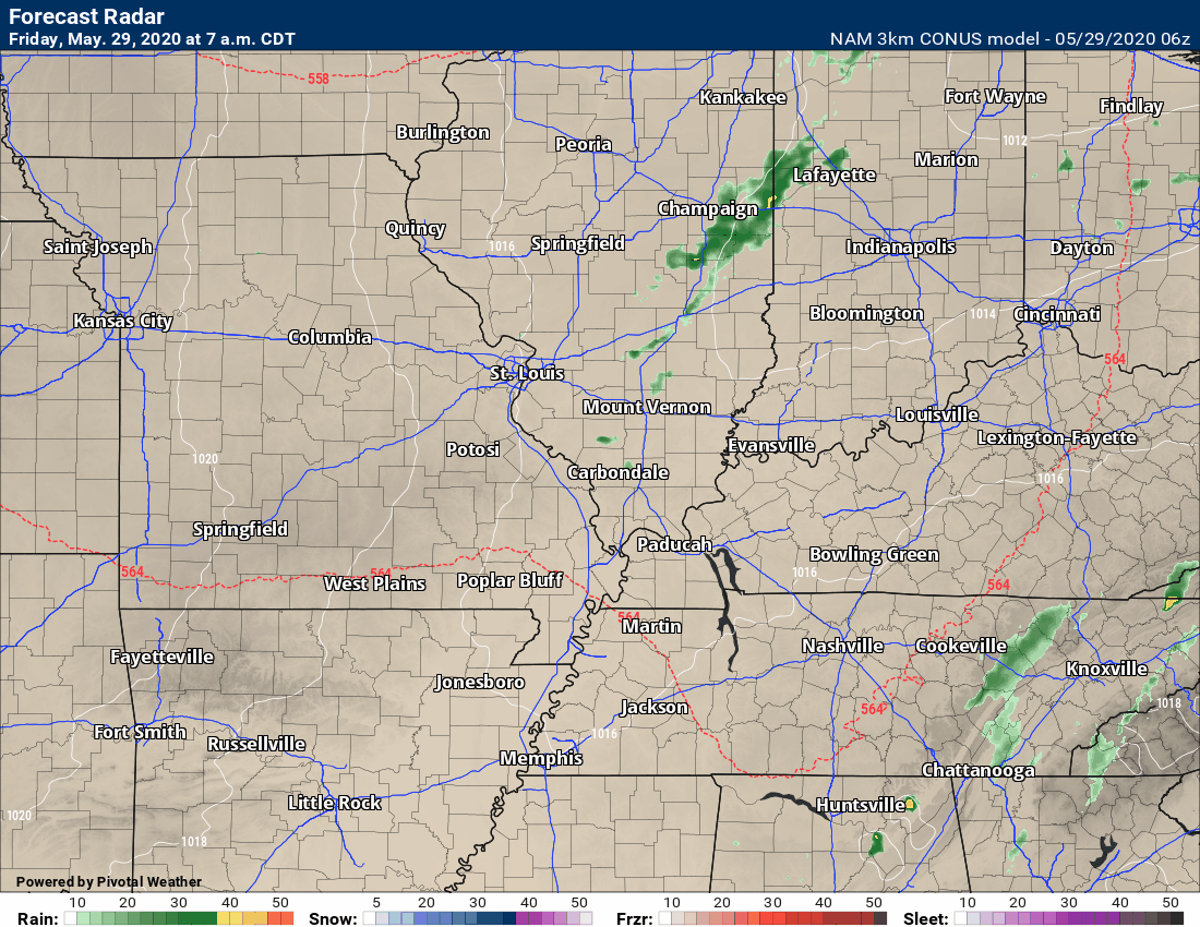
This animation is the 3K American Model.
This animation shows you what radar might look like as the next system pulls through the region. It is a future-cast radar.
Green is rain. Blue is snow. Pink and red represent sleet and freezing rain.
Time-stamp upper left. Click the animation to enlarge it.
.
.
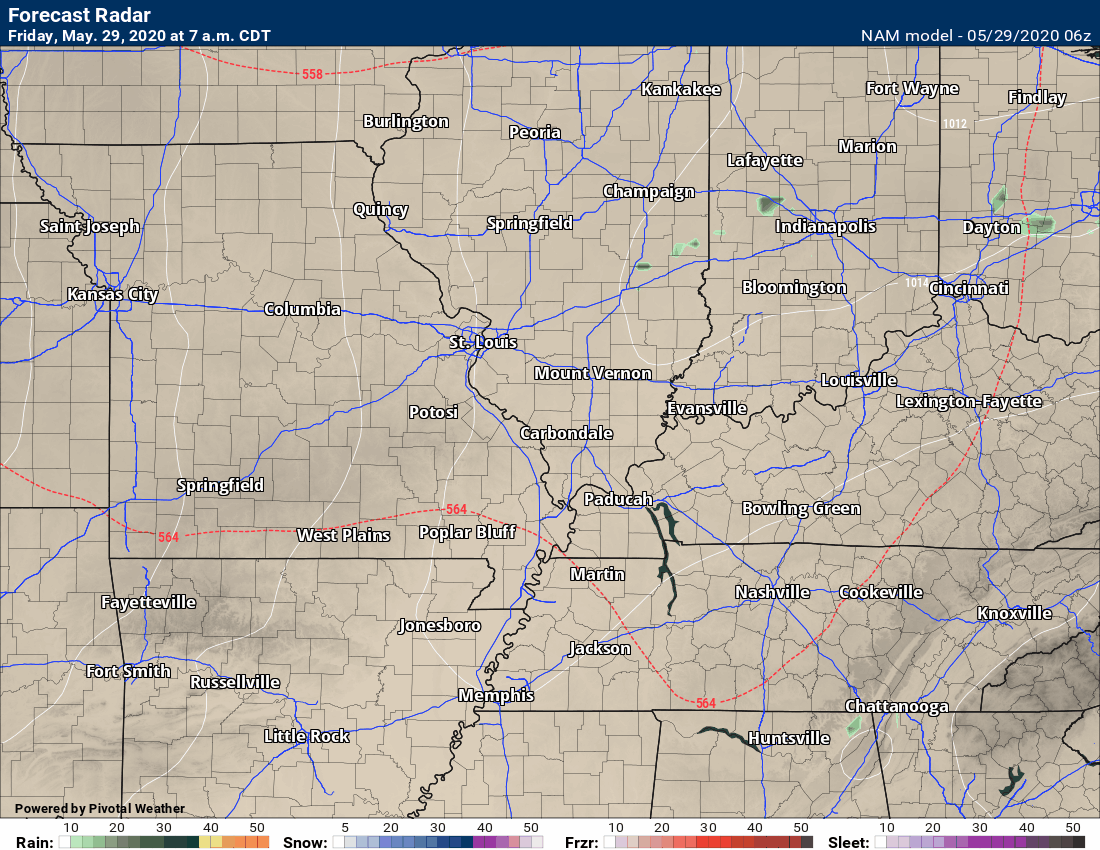
This next animation is the NAM American Model.
This animation shows you what radar might look like as the system pulls through the region. It is a future-cast radar.
Green is rain. Blue is snow. Pink and red represent sleet and freezing rain.
Time-stamp upper left. Click the animation to enlarge it.
.
.
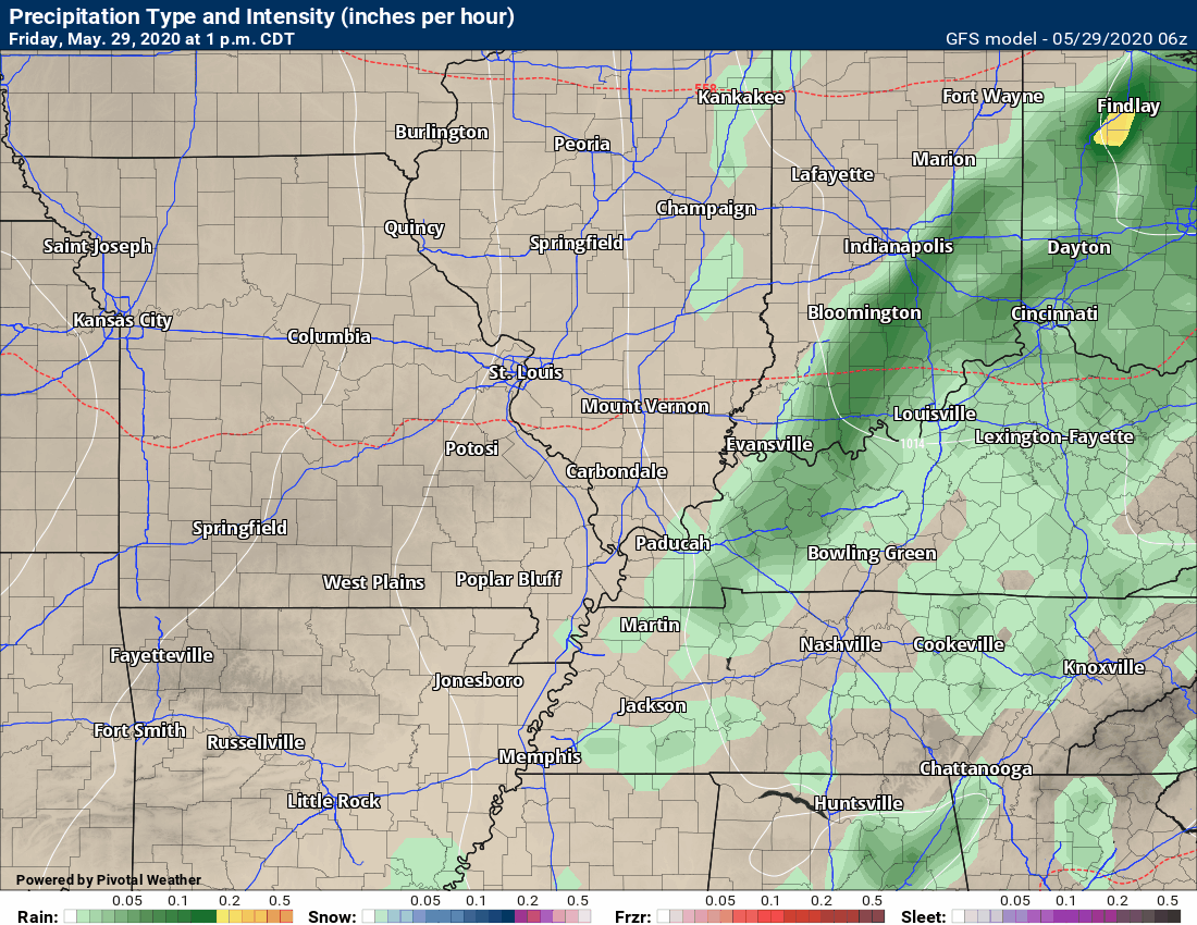
This next animation is the GFS American Model.
This animation shows you what radar might look like as the system pulls through the region. It is a future-cast radar.
Green is rain. Blue is snow. Pink and red represent sleet and freezing rain.
Time-stamp upper left. Click the animation to enlarge it.
Late next week. Some thunderstorm complexes somewhere in the Missouri and Ohio Valley will be possible.
.
.
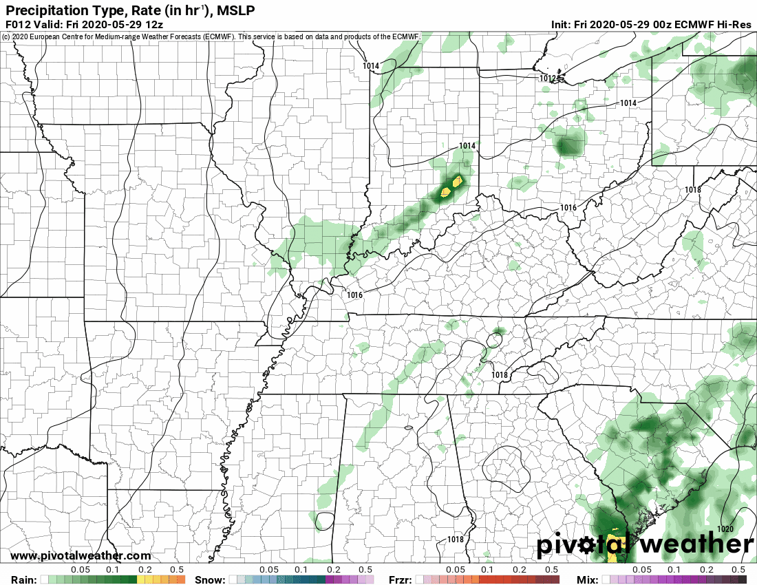
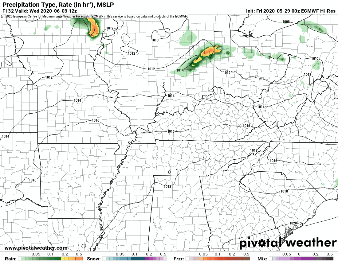
This next animation is the EC Model.
This animation shows you what radar might look like as the system pulls through the region. It is a future-cast radar.
Green is rain. Blue is snow. Pink and red represent sleet and freezing rain.
This is in Zulu time. 12z = 7 AM. 18z = 1 PM. 00z = 7 PM.
Time-stamp upper left. Click the animation to enlarge it.
Today
This one is for late next week. Perhaps some MSC’s/thunderstorm complexes somewhere in the Missouri and Ohio Valleys.
![]()
.

.
Click here if you would like to return to the top of the page.
.
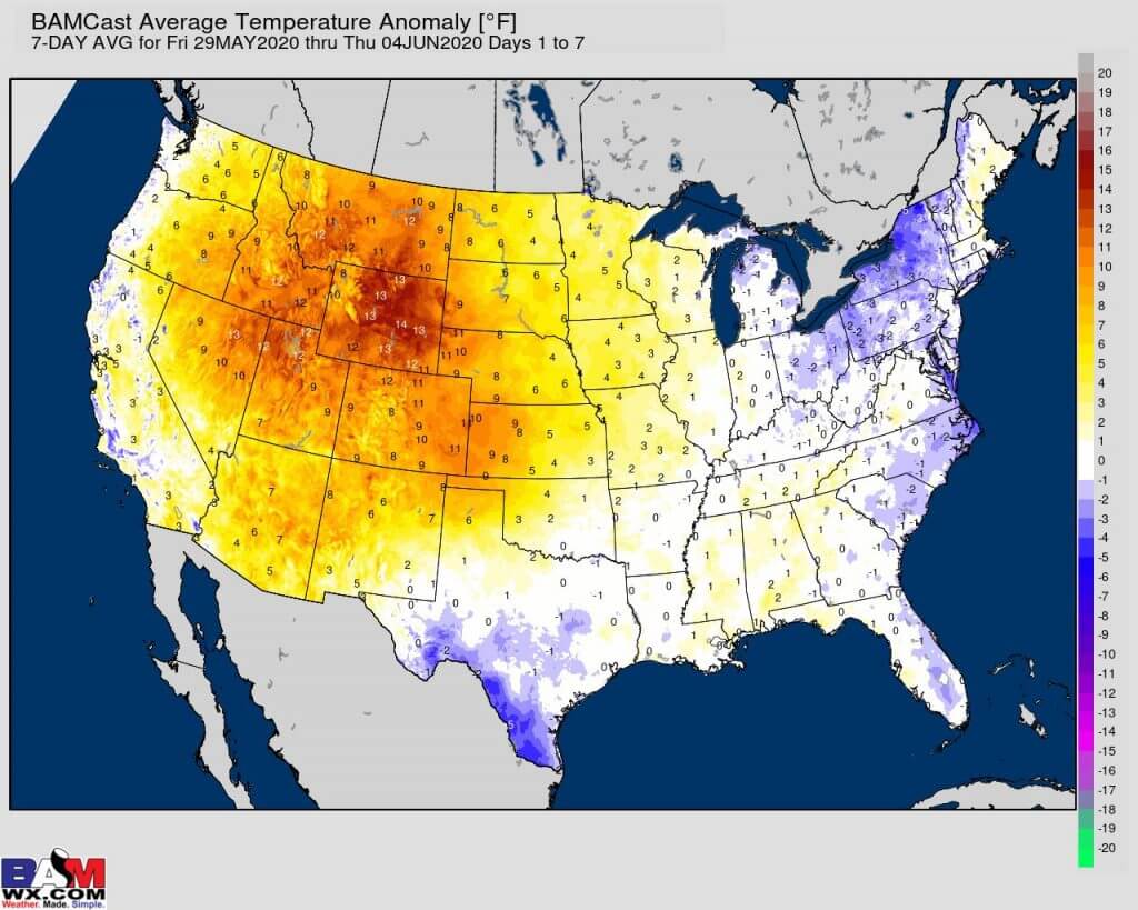
Average high temperatures for this time of the year are around 82 degrees.
Average low temperatures for this time of the year are around 61 degrees.
Average precipitation during this time period ranges from 1.00″ to 1.20″
Yellow and orange colors are above average temperatures. Red is much above average. Light blue and blue are below-average temperatures. Green to purple colors represents much below-average temperatures.
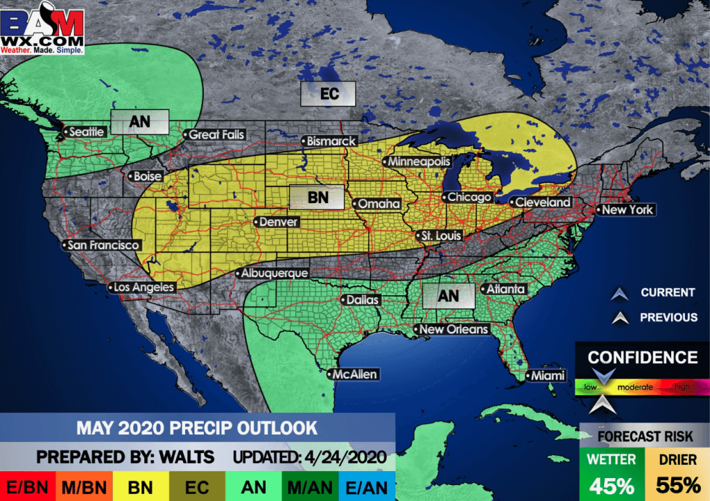
This outlook covers May 29th through June 4th
Click on the image to expand it.
.
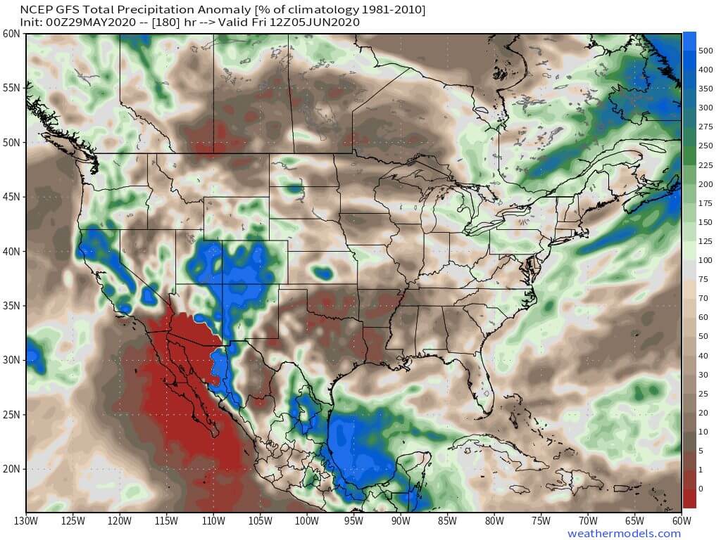
The precipitation forecast is PERCENT OF AVERAGE. Brown is below average. Green is above average. Blue is much above average.
.

Average low temperatures for this time of the year are around 62 degrees
Average precipitation during this time period ranges from 1.00″ to 1.20″
.
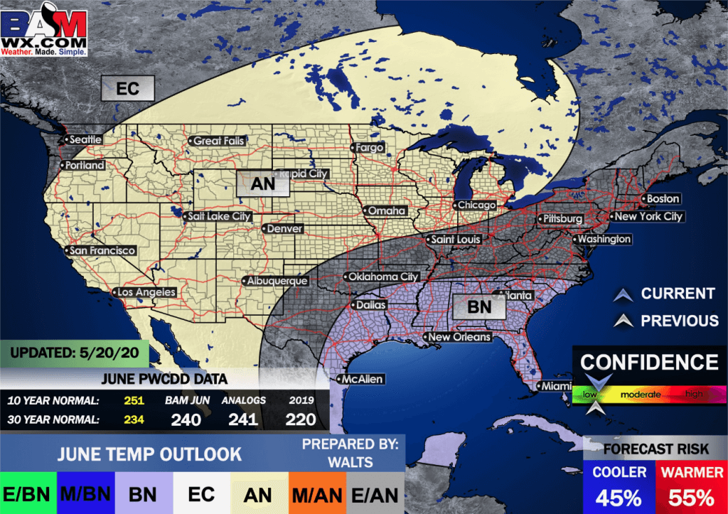
This outlook covers June 5th to June 11th
Click on the image to expand it.

.
The precipitation forecast is PERCENT OF AVERAGE. For example, if your average rainfall is 1.00″ and the graphic shows 25%, then that would mean 0.25″ of rain is anticipated.
.
.

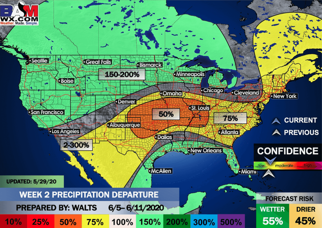
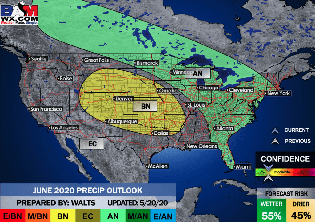
EC = Equal chances of above or below average
BN= Below average
M/BN = Much below average
AN = Above average
M/AN = Much above average
E/AN = Extremely above average
Average low temperatures for this time of the year are around 66 degrees
Average precipitation during this time period ranges from 2.00″ to 2.20″
This outlook covers June 12th through June 25th

.
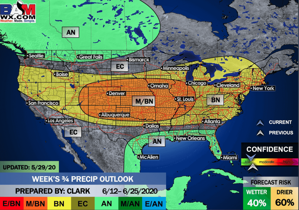
Precipitation outlook
 1
1
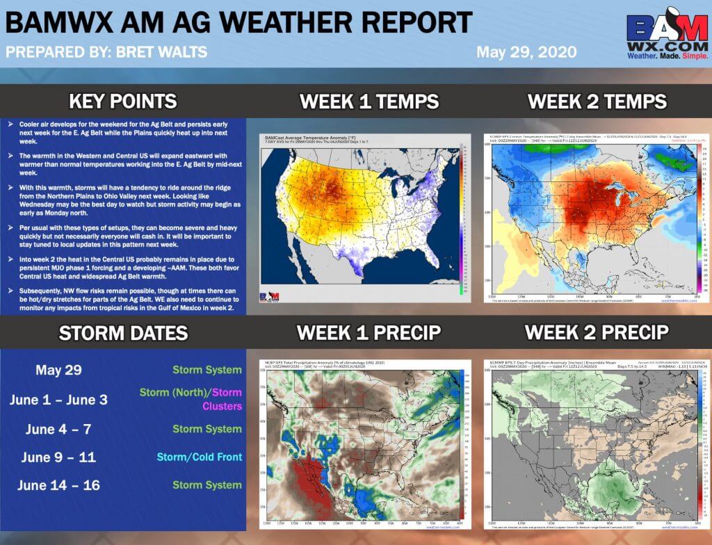
LONG RANGE DISCUSSION
Key Points: This was written by the BAMwx team. I don’t edit it.
Click to enlarge all of the images below
These graphics are updated Monday through Friday between 8:30 AM and 9:30 AM.
NOTE: These may not be updated on Saturday and Sunday.
Click the image below to enlarge it.
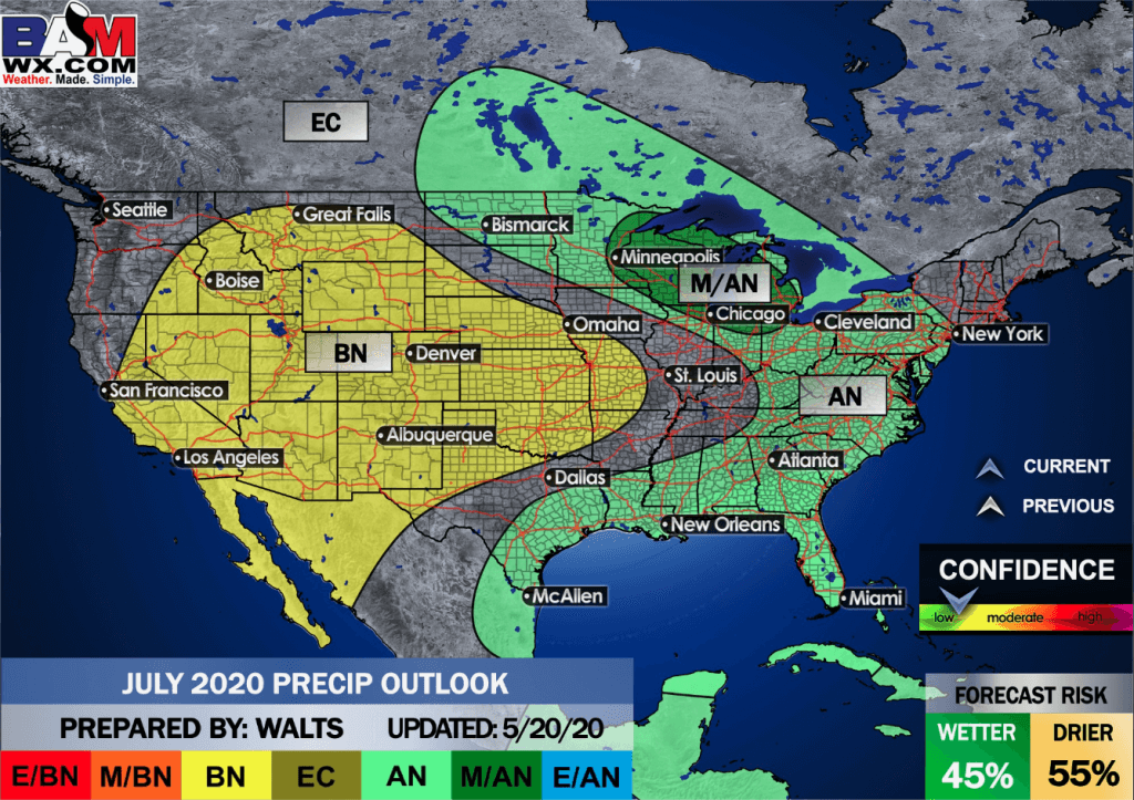
Summer outlook
Click to enlarge it. Then, you can read it better.
June through August
Temperature departures
Precipitation
,
May temperature departures
Click on the images to enlarge them
May precipitation departures
,
June temperature departures
Click on the images to enlarge them
Precipitation outlook
July temperature departures
Click on the images to enlarge them

.
![]()

Great news! The videos are now found in your Weathertalk app and on the WeatherTalk website.
These are bonus videos for subscribers.
The app is for subscribers. Subscribe at www.weathertalk.com/welcome then go to your app store and search for WeatherTalk
Subscribers, PLEASE USE THE APP. ATT and Verizon are not reliable during severe weather. They are delaying text messages.
The app is under WeatherTalk in the app store.

Apple users click here

Android users click here
.

Radar Link: Interactive local city-view radars & regional radars.
You will find clickable warning and advisory buttons on the local city-view radars.
If the radar is not updating then try another one. If a radar does not appear to be refreshing then hit Ctrl F5. You may also try restarting your browser.
Not working? Email me at beaudodson@usawx.com
National map of weather watches and warnings. Click here.
Storm Prediction Center. Click here.
Weather Prediction Center. Click here.
.

Live lightning data: Click here.
.

Interactive GOES R satellite. Track clouds. Click here.
GOES 16 slider tool. Click here.
College of Dupage satellites. Click here
.

Here are the latest local river stage forecast numbers Click Here.
Here are the latest lake stage forecast numbers for Kentucky Lake and Lake Barkley Click Here.
.
.
Find Beau on Facebook! Click the banner.

.
Find Beau on Twitter! Share your weather photos! @beaudodson

 .
.Click here if you would like to return to the top of the page.
Did you know that a portion of your monthly subscription helps support local charity projects? Not a subscriber? Becoming one at www.weathertalk.com
You can learn more about those projects by visiting the Shadow Angel Foundation website and the Beau Dodson News website.
