WeatherTalk monthly operating costs can top $2000.00. Your $3 subscription helps pay for those costs. I work for you.
For $3 a month you can receive the following. You may choose to receive these via your WeatherTalk app or regular text messaging.
- Severe weather app/text alerts from my keyboard to your app/cell phone. These are hand typed by Beau. During tornado outbreaks, you will receive numerous app/text messages telling you exactly where the tornado is located.
- Daily forecast app/texts from my computer to your app/cell phone.
- Social media links sent directly to your app/cell phone. When I update the blog, videos, or Facebook you will receive the link.
- AWARE emails. These emails keep you well ahead of the storm. They give you several days of lead time before significant weather events.
- Direct access to Beau via text and email. Your very own personal meteorologist. I work for you!
- Missouri and Ohio Valley centered video updates
- Long-range weather videos
- Week one, two, three and four temperature and precipitation outlooks.
- Monthly outlooks.
- Your subscription also will help support several local charities.
Haven’t you subscribed? Subscribe at www.beaudodsonweather.com

Example of a recent severe weather alert. I issued this well before the official tornado warning. You would have had plenty of time for you and your family to seek shelter.


Your $3 per month also helps support these local charity projects.

I encourage subscribers to use the app vs regular text messaging. We have found text messaging to be delayed during severe weather. The app typically will receive the messages instantly. I recommend people have three to four methods of receiving their severe weather information.
Remember, my app and text alerts are hand typed and not computer generated. You are being given personal attention during significant weather events.

WWW.WEATHERTALK.COM subscribers, here is my day to day schedule for your weather products.


.
Interactive live weather radar page. Choose the city nearest your location. If one of the city radars won’t load then try a nearby one. Click here.
May 29, 2018
Tuesday Forecast Details
Forecast: The bulk of this systems rain will fall this afternoon into early Wednesday morning. Keep that in mind. Mostly cloudy. Showers and thunderstorms increasingly likely as the remnants of Alberto approach. Warm and humid. Locally heavy rain where storms occur. Rain chances will increase through the day. Highest chances will be afternoon. Temperatures will be highly dependent on cloud cover. Areas with clouds and rain will be cooler. Rain chances are higher over the eastern half of the region vs the western half (SW IL and SE MO).
Temperatures: MO ~ 84 to 88 IL ~ 80 to 85 KY ~ 80 to 85 TN ~ 80 to 85
What is the chance of precipitation? MO ~ 50% (mainly afternoon) IL ~ 50% (mainly afternoon) KY ~ 70% (mainly afternoon) TN ~ 70% (mainly afternoon)
Coverage of precipitation: Becoming numerous
Winds: East and northeast at 5 to 10 mph
What impacts are anticipated from the weather? Wet roads and lightning. Heavy rain possible. Gusty winds.
My confidence in the forecast verifying: High
Is severe weather expected? Unlikely, but monitor updates
The NWS defines severe weather as 58 mph wind or great, 1″ hail or larger, and/or tornadoes
Should I cancel my outdoor plans? Have a plan B
UV Index: 2 to 4
Sunrise: 5:37 AM
.
Alberto has shifted a tad further west. This places more of the region in the risk of heavy rain and even some flash flooding.
.
Tuesday Night Forecast Details:
Forecast: Mostly cloudy. Showers and thunderstorms. Locally heavy rain.
Temperatures: MO ~ 66 to 70 IL ~ 66 to 70 KY ~ 66 to 70 TN ~ 66 to 70
What is the chance of precipitation? MO ~ 60% IL ~ 80% KY ~ 80% TN ~ 80%
Coverage of precipitation: Numerous
Winds: North winds becoming northwest and eventually west at 7 to 14 mph. Gusty, at times.
What impacts are anticipated from the weather? Wet roadways. Lightning. Locally heavy rain.
My confidence in the forecast verifying: Medium
Is severe weather expected? Unlikely, but monitor updates.
The NWS defines severe weather as 58 mph wind or great, 1″ hail or larger, and/or tornadoes
Should I cancel my outdoor plans? Have a plan B
Sunset: 8:07 PM
Moonrise: 8:16 PM Full Moon
Moonset: 5:54 AM
May 30, 2018
Wednesday Forecast Details
Forecast: Partly to mostly cloudy. Warm and humid. Scattered showers and thunderstorms.
Temperatures: MO ~ 84 to 88 IL ~ 85 to 88 KY ~ 85 to 88 TN ~ 85 to 88
What is the chance of precipitation? MO ~ 40% IL ~ 50% KY ~ 50% TN ~ 40%
Coverage of precipitation: Scattered to perhaps numerous (esp early in the day)
Winds: Southwest at 8 to 16 mph and gusty.
What impacts are anticipated from the weather? Wet roads and lightning. Heavy rain possible.
My confidence in the forecast verifying: Medium
Is severe weather expected? Isolated reports of small hail and down burst winds are possible
The NWS defines severe weather as 58 mph wind or great, 1″ hail or larger, and/or tornadoes
Should I cancel my outdoor plans? No, but monitor radars
UV Index: 7 to 9 medium to possibly high (depending on cloud cover)
Sunrise: 5:36 AM
Wednesday Night Forecast Details:
Forecast: Partly cloudy. Warm and humid. Widely scattered showers and thunderstorms.
Temperatures: MO ~ 68 to 72 IL ~ 68 to 72 KY ~ 68 to 72 TN ~ 68 to 72
What is the chance of precipitation? MO ~ 30% IL ~ 30% KY ~ 30% TN ~ 30%
Coverage of precipitation: Widely scattered
Winds: South and southwest at 5 to 10 mph with gusts to 14 mph
What impacts are anticipated from the weather? Wet roadways. Lightning. Locally heavy rain.
My confidence in the forecast verifying: Medium
Is severe weather expected? Isolated reports of small hail and down burst winds are again possible
The NWS defines severe weather as 58 mph wind or great, 1″ hail or larger, and/or tornadoes
Should I cancel my outdoor plans? No, but check radars
Sunset: 8:08 PM
Moonrise: 9:10 PM Waning Gibbous
Moonset: 6:34 AM
May 31, 2018
Thursday Forecast Details
Forecast: Mostly cloudy. Warm and humid. Scattered showers and thunderstorms. Some storms could be severe with high winds and hail.
Temperatures: MO ~ 86 to 90 IL ~ 86 to 90 KY ~ 86 to 90 TN ~ 86 to 90
What is the chance of precipitation? MO ~ 40% IL ~ 40% KY ~ 40% TN ~ 40%
Coverage of precipitation: Scattered
Winds: Southwest at 6 to 12 mph with gusts to 20 mph
What impacts are anticipated from the weather? Wet roads and lightning. Heavy rain possible. Hail and high winds possible.
My confidence in the forecast verifying: Medium
Is severe weather expected? Some storms could become severe. Monitor updates
The NWS defines severe weather as 58 mph wind or great, 1″ hail or larger, and/or tornadoes
Should I cancel my outdoor plans? Monitor updates and radars
UV Index: 9 to 11 High
Sunrise: 5:36 AM
Thursday Night Forecast Details:
Forecast: Partly to mostly cloudy. Scattered showers and thunderstorms. Some storms could be intense.
Temperatures: MO ~ 68 to 72 IL ~ 68 to 72 KY ~ 68 to 72 TN ~ 68 to 72
What is the chance of precipitation? MO ~ 40% IL ~ 40% KY ~ 40% TN ~ 40%
Coverage of precipitation: Scattered to perhaps numerous
Winds: South and southwest at 5 to 10 mph
What impacts are anticipated from the weather? Wet roadways. Lightning. Locally heavy rain. Hail and high winds.
My confidence in the forecast verifying: Medium
Is severe weather expected? Some storms could become severe.
The NWS defines severe weather as 58 mph wind or great, 1″ hail or larger, and/or tornadoes
Should I cancel my outdoor plans? No, but check radars
Sunset: 8:09 PM
Moonrise: 10:01 PM Waning Gibbous
Moonset: 7:18 AM
June 01, 2018
Friday Forecast Details
Forecast: Partly sunny. Hot and muggy. Isolated showers and thunderstorms.
Temperatures: MO ~ 88 to 94 IL ~ 88 to 94 KY ~ 88 to 94 TN ~ 88 to 94
What is the chance of precipitation? MO ~ 20% IL ~ 20% KY ~ 20% TN ~ 20%
Coverage of precipitation: Isolated
Winds: Southwest at 5 to 10 mph
What impacts are anticipated from the weather? Wet roads and lightning. Heavy rain possible.
My confidence in the forecast verifying: Medium
Is severe weather expected? Isolated reports of small hail and down burst winds are again possible
The NWS defines severe weather as 58 mph wind or great, 1″ hail or larger, and/or tornadoes
Should I cancel my outdoor plans? No, but check radars
UV Index: 10 High
Sunrise: 5:36 AM
Friday Night Forecast Details:
Forecast: Partly cloudy. An isolated thunderstorm possible.
Temperatures: MO ~ 66 to 74 IL ~ 68 to 72 KY ~ 68 to 70 TN ~ 68 to 72
What is the chance of precipitation? MO ~ 20% IL ~ 20% KY ~ 20% TN ~ 20%
Coverage of precipitation: Isolated
Winds: Southwest at 5 to 10 mph
What impacts are anticipated from the weather? Wet roadways. Lightning. Locally heavy rain.
My confidence in the forecast verifying: Medium
Is severe weather expected? Unlikely
The NWS defines severe weather as 58 mph wind or great, 1″ hail or larger, and/or tornadoes
Should I cancel my outdoor plans? No, but check radars
Sunset: 8:09 PM
Moonrise: 10:43 PM Waning Gibbous
Moonset: 8:06 AM
June 02, 2018
Saturday Forecast Details
Forecast: Partly sunny. Hot and humid. Scattered showers and thunderstorms.
Temperatures: MO ~ 86 to 92 IL ~ 86 to 92 KY ~ 86 to 92 TN ~ 86 to 92
What is the chance of precipitation? MO ~ 30% IL ~ 30% KY ~ 30% TN ~ 30%
Coverage of precipitation: Scattered
Winds: Variable at 5 to 10 mph with gusts to 14
What impacts are anticipated from the weather? Wet roads and lightning. Heavy rain possible.
My confidence in the forecast verifying: Medium
Is severe weather expected? Some storms could approach severe levels. Monitor updates.
The NWS defines severe weather as 58 mph wind or great, 1″ hail or larger, and/or tornadoes
Should I cancel my outdoor plans? No, but check radars
UV Index: 10 High
Sunrise: 5:35 AM
Saturday Night Forecast Details:
Forecast: Partly cloudy. Scattered thunderstorms possible.
Temperatures: MO ~ 65 to 70 IL ~ 64 to 68 KY ~ 65 to 70 TN ~ 65 to 70
What is the chance of precipitation? MO ~ 40% IL ~ 40% KY ~ 40% TN ~ 40%
Coverage of precipitation: Scattered
Winds: Southwest at 5 to 10 mph. Winds becoming variable.
What impacts are anticipated from the weather? Wet roadways. Lightning. Locally heavy rain.
My confidence in the forecast verifying: Medium
Is severe weather expected? Monitor updates
The NWS defines severe weather as 58 mph wind or great, 1″ hail or larger, and/or tornadoes
Should I cancel my outdoor plans? No, but check radars
Sunset: 8:09 PM
Moonrise: 11:31 PM Waning Gibbous
Moonset: 8:57 AM
June 03, 2018
Sunday Forecast Details
Forecast: Partly sunny. Scattered thunderstorms possible. Not as warm.
Temperatures: MO ~ 83 to 86 IL ~ 83 to 86 KY ~ 83 to 86 TN ~ 83 to 86
What is the chance of precipitation? MO ~ 30% IL ~ 30% KY ~ 30% TN ~ 30%
Coverage of precipitation: Scattered
Winds: North and northwest at 5 to 10 mph with gusts to 15 mph
What impacts are anticipated from the weather? Wet roads and lightning.
My confidence in the forecast verifying: Medium
Is severe weather expected? Isolated reports of small hail and down burst winds are again possible
The NWS defines severe weather as 58 mph wind or great, 1″ hail or larger, and/or tornadoes
Should I cancel my outdoor plans? No, but check radars
UV Index: 10 High
Sunrise: 5:35 AM
Sunday Night Forecast Details:
Forecast: Mostly clear and cooler.
Temperatures: MO ~ 60 to 65 IL ~ 60 to 65 KY ~ 60 to 65 TN ~ 60 to 65
What is the chance of precipitation? MO ~ 10% IL ~ 10% KY ~ 10% TN ~ 10%
Coverage of precipitation: Most likely none, but monitor updates.
Winds: North at 5 to 10 mph
What impacts are anticipated from the weather? Most likely none.
My confidence in the forecast verifying: Medium
Is severe weather expected? Unlikely
The NWS defines severe weather as 58 mph wind or great, 1″ hail or larger, and/or tornadoes
Should I cancel my outdoor plans? No
Sunset: 8:11 PM
Moonrise: 11:59 PM Waning Gibbous
Moonset: 9:50 AM
.
RAIN TOTALS
It is important to remember, late spring and summer thunderstorms can drop a lot of rain in a short amount of time. Rain rates can occasionally exceed 1.5 to 2″ per hour. This can cause brief periods of flash flooding or ponding of water.
It is next to impossible to forecast which county will receive more rain than a neighboring county. Typical, for our region. Your neighbor can pick up a heavy thunderstorm and you end up with just a few drops.
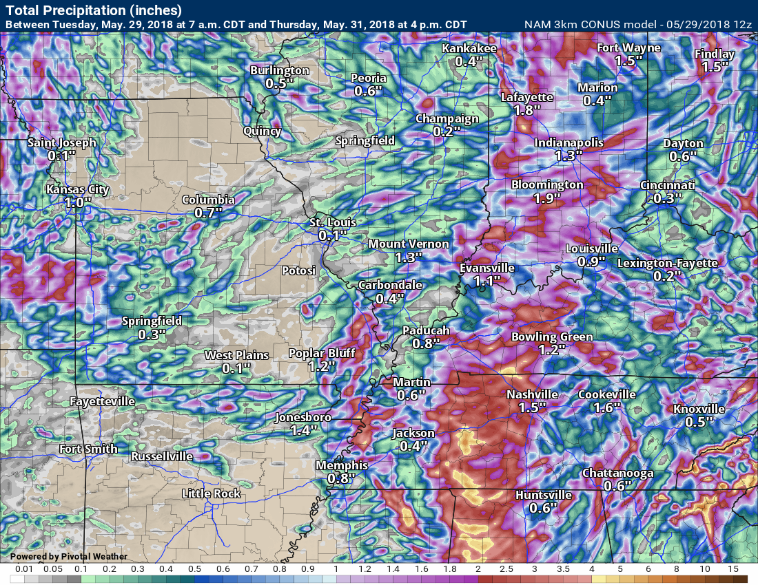
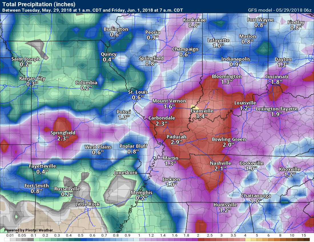
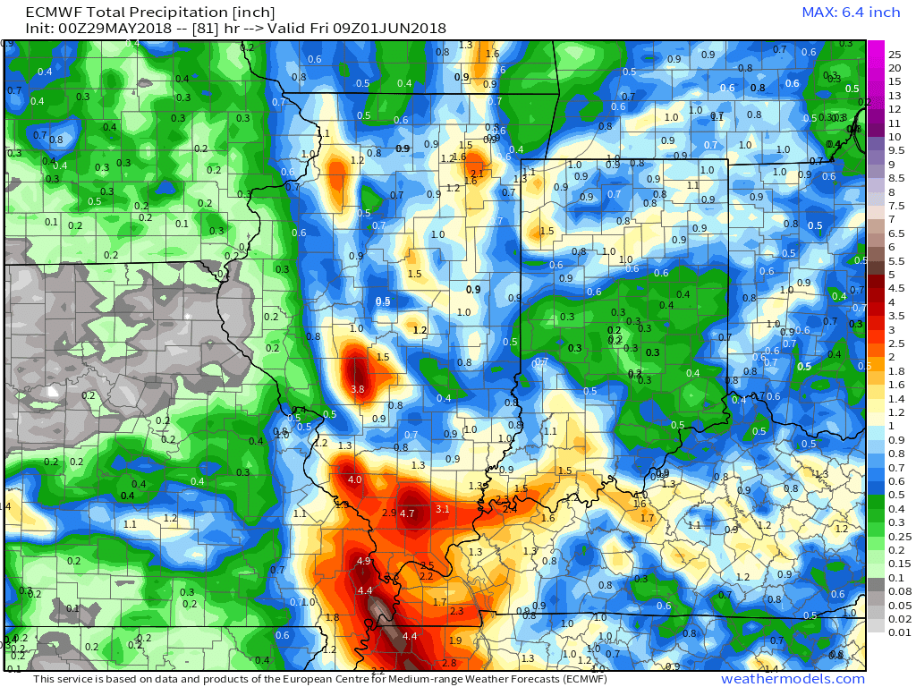
Let’s look at four models. These are showing you rain totals through Wednesday.
The bulk of this rain will fall with Alberto.
The system has shifted westward a tad over the last 12 to 24 hours. This places more of the region in the path of heavy rain.
There still remain some questions about the exact track.
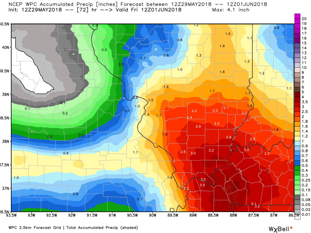
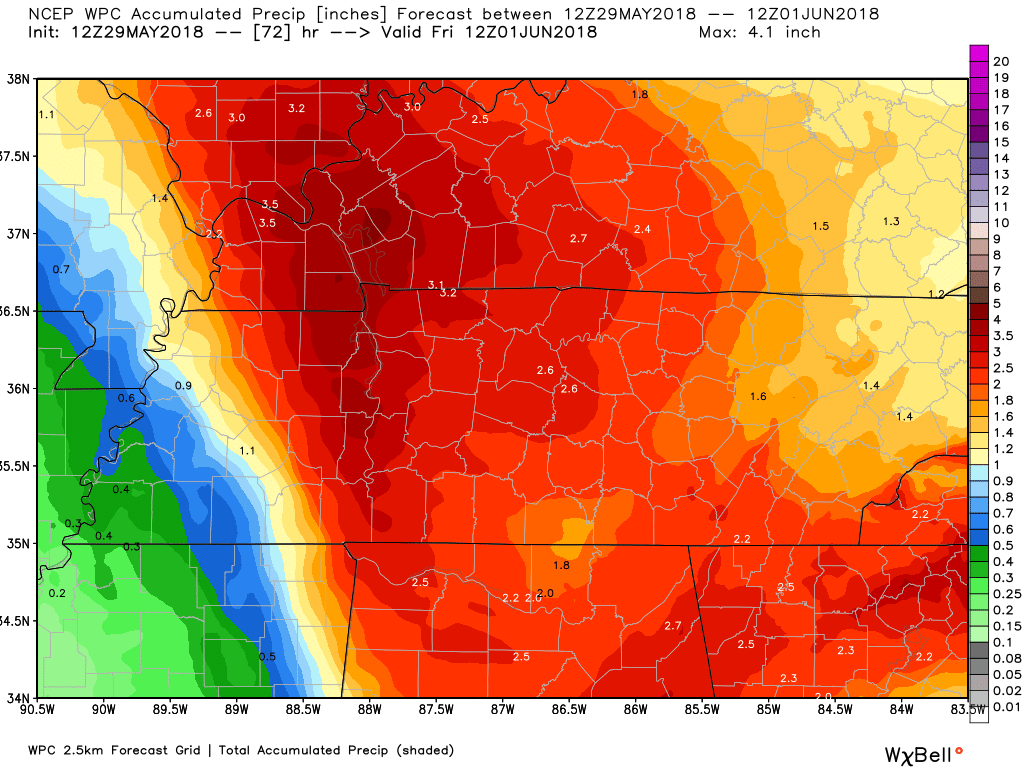
WPC rainfall forecast (NOAA)
Zoomed in on IL/MO and then KY/TN zoom (click to enlarge)
.
.
NAM model
GFS model
EC model

Interactive Radars:
Interactive live weather radar page. Choose the city nearest your location. If one of the city radars won’t load then try a nearby one. Click here.

Questions? Broken links? Other?
You may email me at beaudodson@usawx.com

The National Weather Service defines a severe thunderstorm as one that produces quarter size hail or larger, 58 mph winds or greater, and/or a tornado.
Tuesday into Tuesday night: The remnants of Alberto are moving through the region. Locally heavy rain is likely along the path of this system. Rain totals of one to three inches will be possible. Pockets of higher totals are likely.
The core of the heavy rain will likely fall near the center of the system. Those higher totals will likely be over southern Illinois, western Kentucky, and portions of western Tennessee.
There is a small risk of some funnel clouds being reported. Occasionally these systems do produce short lived tornadoes. The risk is low, but perhaps not zero.
Wednesday through Saturday: Storms may approach severe levels Wednesday afternoon and evening. Severe storms are possible, Thursday afternoon and night. Damaging wind and large hail will be possible.
Storms on Friday and Saturday could approach severe levels. Monitor updates.
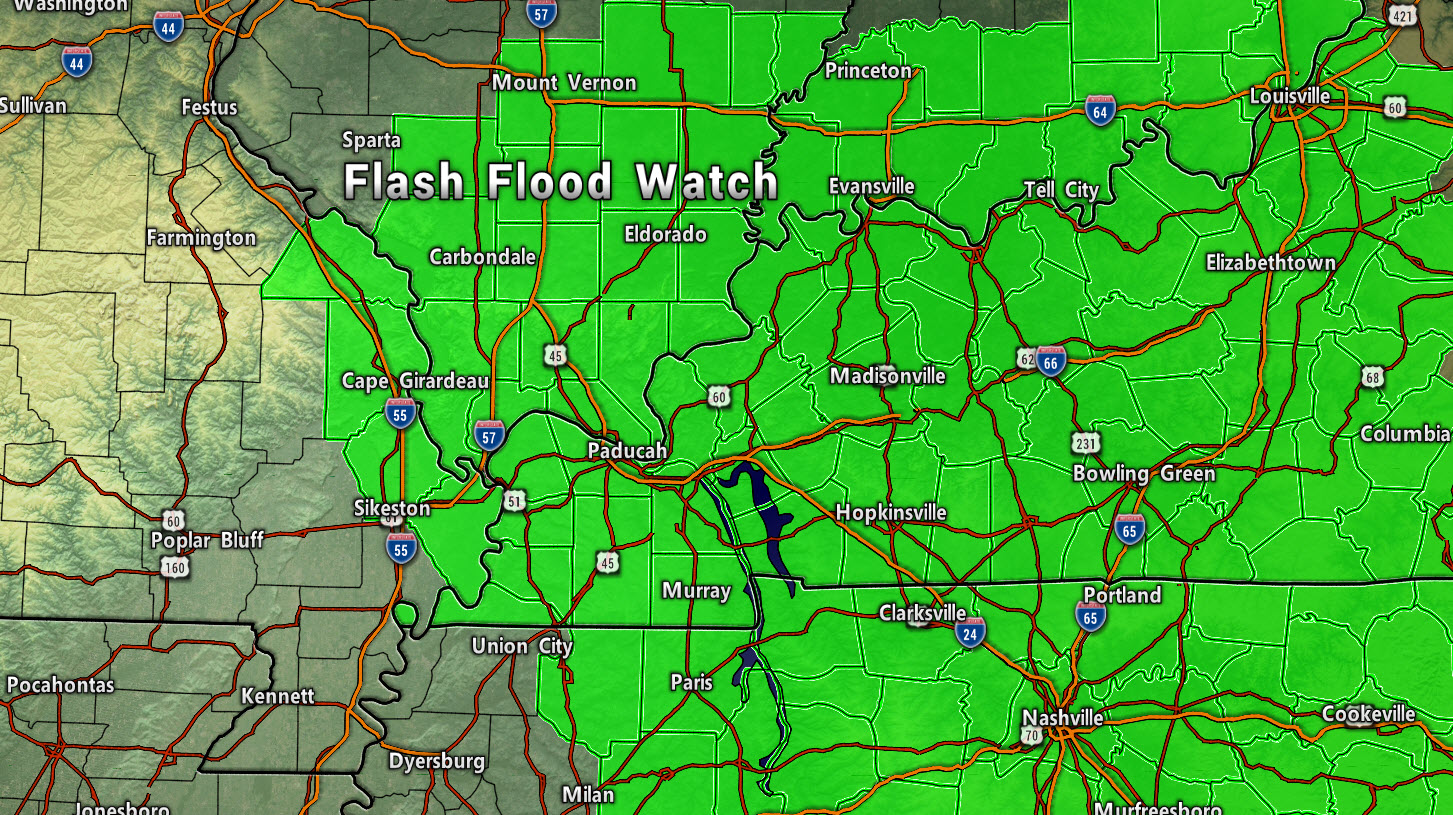
Heavy rain will be a concern over the coming days. There will be plenty of moisture available for heavy/tropical downpours. Flash flood warnings are possible for some of our local counties.
We do have a flash flood watch into Wednesday morning. Counties in green.
.
![]()
Interactive live weather radar page. Choose the city nearest your location. If one of the cities does not work then try a nearby one. Click here.
National map of weather watches and warnings. Click here.
Storm Prediction Center. Click here.
Weather Prediction Center. Click here.

Live lightning data: Click here.

Interactive GOES R satellite. Track clouds. Click here.

Here are the latest local river stage forecast numbers Click Here.
Here are the latest lake stage forecast numbers for Kentucky Lake and Lake Barkley Click Here.

The spring and preliminary summer outlooks have been posted for subscribers. Scroll down to see the outlook.
Not a subscriber? Learn more at this link.

Weather Headlines
- The remnants of Alberto will be the main weather story.
- The system has shifted about 50 miles further west.
- Locally heavy rain. Flash flooding concerns.
- Warm and muggy week ahead
The main weather story continues to be the remnants of Tropical Storm Alberto.
Alberto is moving towards our region from the Tennessee Valley. It will continue to move northward over the next 24 to 48 hours.
The brunt of the system will move through our region today and tonight. Rain totals of one to three inches will likely occur in and near the center of the system. There will be bands of heavy rain elsewhere, as well.
I would not be surprised if some areas exceed three inches of rain.
Tropical systems are notorious for surprises. If rain showers train over the same areas then some places could have water issues. Monitor any flash flood warnings that may need to be issued.
Avoid flooded roadways.
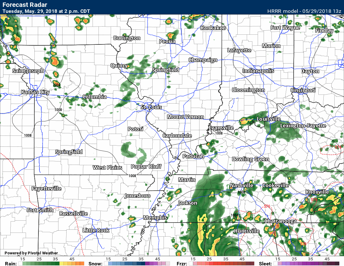
Here is the high res SPC WRF model guidance future-cast radar.
.
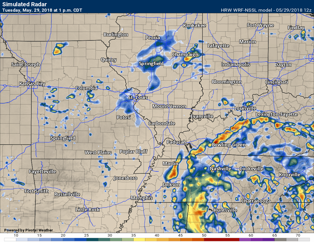
.
Here is the NAM 3K model future-cast radar. One of many models. You can see the track of Alberto through our local area.
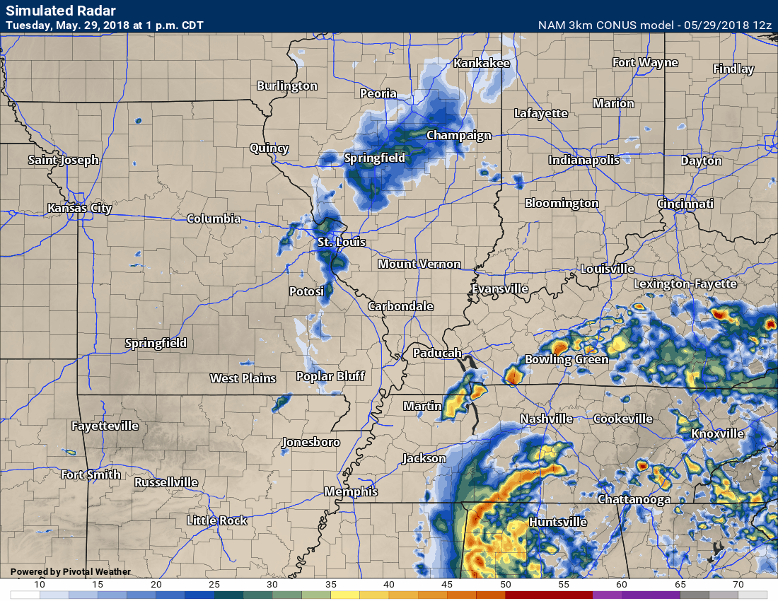
.
Here is the Hrrr model guidance (it does not go out quite as far)
.
.
There will also be some gusty winds as the center passes through the region. Winds of 20 to 30 mph will be possible. Nothing extreme.
Occasionally these systems produce funnel clouds or short lived tornadoes. The risk appears to be low.
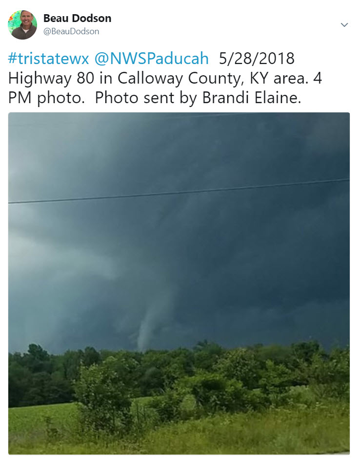
There was a funnel cloud in Calloway County Monday afternoon. There were some high winds reported in that area.
Here is a photograph of that funnel cloud.
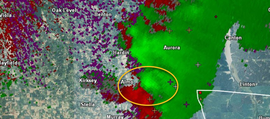
Here is the rotation on radar. Another eye witness saw the cloud rotating.
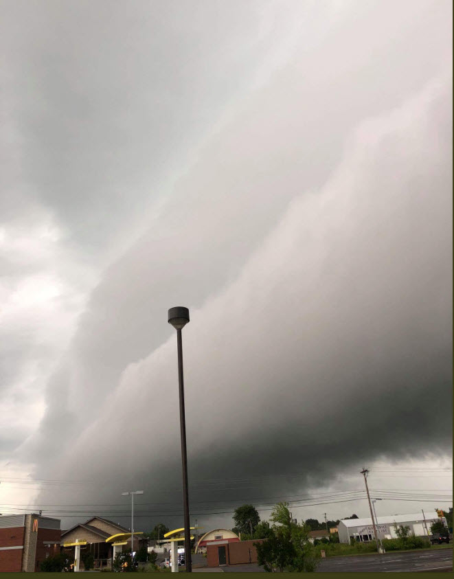
This next photo was taken by Jason Darnall. This was near Draffenville, Kentucky, Monday afternoon.
High dew points, high PWAT values, and the bands of Alberto are responsible for these dramatic clouds.
The remnants of Alberto will push out of the region Wednesday morning.
There will still be some shower and thunderstorms in the forecast through the weekend. Rain chances Wednesday through Friday will range from 30% to 40%.
There are questions about Saturday and Sunday. Some of the charts are showing a series of disturbances moving through the region. Confidence in the outcome is low.
Storms that form over the coming days could be intense. Heavy rain is a concern. PWAT values will remain high. PWAT is a measure of moisture in the lower atmosphere. There could also be some down-burst winds in isolated locations. These can occasionally cause damage. Lightning will be a concern for outdoor activities.
Highs Wednesday through Saturday will be in the upper 80’s to lower 90’s. Heat index values could approach the 94 to 98 degree range. It will be hot and muggy. Summer air.
Don’t forget to check on the elderly during these hot spells.
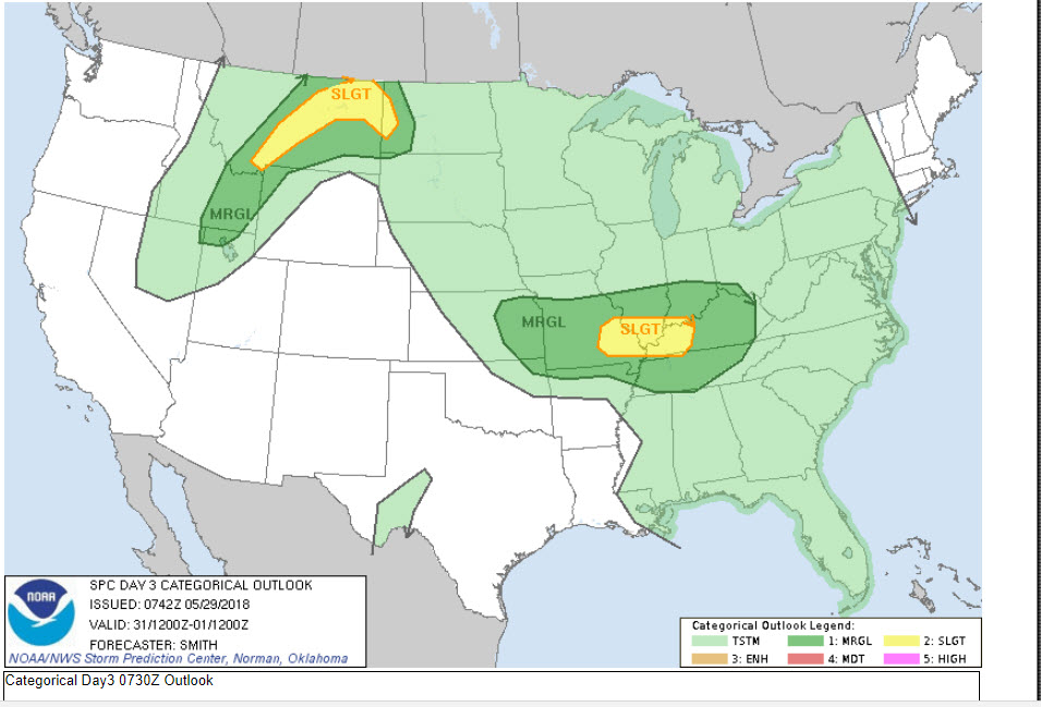
Thursday Severe Weather Risk
I am monitoring Thursday and Thursday night for the risk of severe thunderstorms. Damaging wind is the main concern. Monitor updates moving forward.
The Storm Prediction Center has outlined our region for a risk of severe weather Thursday.
CAPE numerous will range from 2500 to 4000. Dew points well into the 70’s. Muggy air. There will be wind shear available for storms. Lift index values of -8 or lower. All of that equals the potential of severe thunderstorms.
Dark green is the level one risk zone. Yellow is the level two risk zone. Five is the highest risk SPC issues.
We will need to keep an eye on Thursday afternoon and night.
.

A new weather podcast is now available! Weather Geeks (which you might remember is on The Weather Channel each Sunday)
To learn more visit their website. Click here.
![]()

WeatherBrains Episode 643
Tonight’s Guest WeatherBrain is a Research Meteorologist at National Severe Storms Laboratory and a visiting Professor of Atmospheric Science at Desert Research Institute and the University of Nevada-Reno. He is the author of the recent AMS Book: Verner Soumi: The Life and Work of the Founder of Satellite Meteorology. He joins us tonight from his daughter’s home in Sacramento. Please welcome Dr. John Lewis to WeatherBrains.
Throughout his career, Dr. Lewis has conducted research that has combined weather analysis with numerical weather prediction. His professional experience has been divided between work in government labs including operational prediction centers and academia. In the past decade, he has led a national research project focused on the weather over the Gulf of Mexico, Project GUFMEX, explored the use of adjoint methods to study model sensitivity, and contributed to the history of science. In 1998, the Environmental Research Laboratories of NOAA assigned Dr. Lewis to Desert Research Institute on a long-term duty assignment. This assignment was made in connection with a 5-year plan to improve weather forecasting in the Western United States. Central to this effort is the use of adjoint models to clarify the relative importance of the various meteorological fields used to initialize deterministic prediction models.
Other discussions in this weekly podcast include topics like:
- Extremes: 102 at Rio Grande Village, TX, and 23 at Stanley, ID, Crested Butte, CO, & Gothic, CO
- Non-tropical low off the west coast of Florida
- Severe weather Tuesday over Mid-Atlantic states
- Serious drought from AZ to West TX
- Fairly warm across the continental US
- Astronomy Outlook with Tony Rice
- and more!
Previous episodes can be viewed by clicking here.

We offer interactive local city live radars and regional radars. If a radar does not update then try another one. If a radar does not appear to be refreshing then hit Ctrl F5. You may also try restarting your browser.
The local city view radars also have clickable warnings.
During the winter months, you can track snow and ice by clicking the winterize button on the local city view interactive radars.
You may email me at beaudodson@usawx.com
Find me on Facebook!

Find me on Twitter!

Did you know that a portion of your monthly subscription helps support local charity projects?
You can learn more about those projects by visiting the Shadow Angel Foundation website and the Beau Dodson News website.

I encourae subscribers to use the app vs regular text messaging. We have found text messaging to be delayed during severe weather. The app typically will receive the messages instantly. I recommend people have three to four methods of receiving their severe weather information.
Remember, my app and text alerts are hand typed and not computer generated. You are being given personal attention during significant weather events.
