

Monday Forecast Details
Forecast: A mix of sun and clouds. Hot and humid. Scattered thunderstorms forming during the afternoon and evening hours. Storms that form could produce heavy rain. A band of storms may form across Kentucky and Tennessee. This band of storms would then move southeast to northwest (because of Alberto).
Temperatures: MO ~ 88 to 90 IL ~ 88 to 90 KY ~ 86 to 90 TN ~ 86 to 90
What is the chance of precipitation? MO ~ 30% IL ~ 40% KY ~ 50% (mainly afternoon) TN ~ 50% (mainly afternoon)
Coverage of precipitation: Scattered to perhaps numerous (if that band forms mentioned above).
Winds: Northeast winds 5 to 10 mph with gusts to 15 mph
What impacts are anticipated from the weather? Scattered wet roads and lightning. Locally heavy downpours.
My confidence in the forecast verifying: Medium
Is severe weather expected? Unlikely, but isolated reports of hail or strong winds are always possible with summer type thunderstorms.
The NWS defines severe weather as 58 mph wind or great, 1″ hail or larger, and/or tornadoes
Should I cancel my outdoor plans? No, but monitor radars.
UV Index: 9 – Very high
Sunrise: 5:37 AM
Monday Night Forecast Details:
Forecast: Partly cloudy. A few scattered showers and thunderstorms (mainly before 10 PM). Locally heavy rain where storms occur.
Temperatures: MO ~ 66 to 70 IL ~ 66 to 70 KY ~ 66 to 70 TN ~ 66 to 70
What is the chance of precipitation? MO ~ 30% IL ~ 40% KY ~ 50% TN ~ 50%
Coverage of precipitation: Scattered
Winds: Northeast and east at 4 to 8 mph with gusts to 12 mph
What impacts are anticipated from the weather? Scattered wet roadways. Lightning. Locally heavy rain if thunderstorms form.
My confidence in the forecast verifying: Medium
Is severe weather expected? Unlikely
The NWS defines severe weather as 58 mph wind or great, 1″ hail or larger, and/or tornadoes
Should I cancel my outdoor plans? No, but check radars
Sunset: 8:07 PM
Moonrise: 7:18 PM Waxing Gibbous
Moonset: 5:16 AM
May 29, 2018
Tuesday Forecast Details
Forecast: Mostly cloudy. Showers and thunderstorms increasingly likely as the remnants of Alberto approach. Warm and humid. Locally heavy rain where storms occur. Rain chances will increase through the day. Highest chances will be afternoon. Temperatures will be highly dependent on cloud cover. Areas with clouds and rain will be cooler. Rain chances are higher over the eastern half of the region vs the western half (SW IL and SE MO).
Temperatures: MO ~ 84 to 88 IL ~ 80 to 85 KY ~ 80 to 85 TN ~ 80 to 85
What is the chance of precipitation? MO ~ 60% (mainly afternoon) IL ~ 60% (mainly afternoon) KY ~ 70% to 80% (mainly afternoon) TN ~ 70% (mainly afternoon)
Coverage of precipitation: Scattered to numerous
Winds: East and northeast at 5 to 10 mph
What impacts are anticipated from the weather? Wet roads and lightning. Heavy rain possible. Gusty winds.
My confidence in the forecast verifying: High
Is severe weather expected? Unlikely, but monitor updates
The NWS defines severe weather as 58 mph wind or great, 1″ hail or larger, and/or tornadoes
Should I cancel my outdoor plans? Have a plan B
UV Index: 2 to 4
Sunrise: 5:37 AM
Tuesday Night Forecast Details:
Forecast: Mostly cloudy. Showers and thunderstorms. Locally heavy rain. Most numerous across southern Illinois and western Kentucky/Tennessee. Less coverage the further west you travel.
Temperatures: MO ~ 66 to 70 IL ~ 66 to 70 KY ~ 66 to 70 TN ~ 66 to 70
What is the chance of precipitation? MO ~ 40% IL ~ 70% KY ~ 70% to 80% TN ~ 70%
Coverage of precipitation: Scattered to numerous
Winds: North winds becoming northwest and eventually west at 7 to 14 mph. Gusty, at times.
What impacts are anticipated from the weather? Wet roadways. Lightning. Locally heavy rain.
My confidence in the forecast verifying: Medium
Is severe weather expected? Severe weather is not anticipated.
The NWS defines severe weather as 58 mph wind or great, 1″ hail or larger, and/or tornadoes
Should I cancel my outdoor plans? Have a plan B
Sunset: 8:07 PM
Moonrise: 8:16 PM Full Moon
Moonset: 5:54 AM
May 30, 2018
Wednesday Forecast Details
Forecast: Partly cloudy. Warm and humid. Scattered showers and thunderstorms.
Temperatures: MO ~ 85 to 90 IL ~ 85 to 88 KY ~ 85 to 88 TN ~ 85 to 88
What is the chance of precipitation? MO ~ 30% IL ~ 40% KY ~ 40% TN ~ 40%
Coverage of precipitation: Scattered
Winds: Southwest at 8 to 16 mph and gusty.
What impacts are anticipated from the weather? Wet roads and lightning. Heavy rain possible.
My confidence in the forecast verifying: Medium
Is severe weather expected? Isolated reports of small hail and down burst winds are possible
The NWS defines severe weather as 58 mph wind or great, 1″ hail or larger, and/or tornadoes
Should I cancel my outdoor plans? No, but monitor radars
UV Index: 7 to 9 medium to possibly high (depending on cloud cover)
Sunrise: 5:36 AM
Wednesday Night Forecast Details:
Forecast: Partly cloudy. Warm and humid. Widely scattered showers and thunderstorms.
Temperatures: MO ~ 68 to 72 IL ~ 68 to 72 KY ~ 68 to 72 TN ~ 68 to 72
What is the chance of precipitation? MO ~ 30% IL ~ 30% KY ~ 30% TN ~ 30%
Coverage of precipitation: Widely scattered
Winds: Southwest at 5 to 10 mph with gusts to 14 mph
What impacts are anticipated from the weather? Wet roadways. Lightning. Locally heavy rain.
My confidence in the forecast verifying: Medium
Is severe weather expected? Isolated reports of small hail and down burst winds are again possible
The NWS defines severe weather as 58 mph wind or great, 1″ hail or larger, and/or tornadoes
Should I cancel my outdoor plans? No, but check radars
Sunset: 8:08 PM
Moonrise: 9:10 PM Waning Gibbous
Moonset: 6:34 AM
May 31, 2018
Thursday Forecast Details
Forecast: Mostly cloudy. Warm and humid. Scattered showers and thunderstorms.
Temperatures: MO ~ 86 to 90 IL ~ 86 to 90 KY ~ 86 to 90 TN ~ 86 to 90
What is the chance of precipitation? MO ~ 40% IL ~ 40% KY ~ 40% TN ~ 40%
Coverage of precipitation: Scattered
Winds: Southwest at 6 to 12 mph with gusts to 18 mph
What impacts are anticipated from the weather? Wet roads and lightning. Heavy rain possible.
My confidence in the forecast verifying: Medium
Is severe weather expected? Isolated reports of small hail and down burst winds are again possible
The NWS defines severe weather as 58 mph wind or great, 1″ hail or larger, and/or tornadoes
Should I cancel my outdoor plans? Monitor updates and radars
UV Index: 4 to 6 Low to medium (will need to monitor cloud cover)
Sunrise: 5:36 AM
Thursday Night Forecast Details:
Forecast: Partly to mostly cloudy. Scattered showers and thunderstorms.
Temperatures: MO ~ 68 to 72 IL ~ 68 to 72 KY ~ 68 to 72 TN ~ 68 to 72
What is the chance of precipitation? MO ~ 30% IL ~ 30% KY ~ 30% TN ~ 30%
Coverage of precipitation: Scattered
Winds: South and southwest at 5 to 10 mph
What impacts are anticipated from the weather? Wet roadways. Lightning. Locally heavy rain.
My confidence in the forecast verifying: Medium
Is severe weather expected? Unlikely, but monitor evening storms. Some storms could be strong with heavy rain, gusty winds, and small hail.
The NWS defines severe weather as 58 mph wind or great, 1″ hail or larger, and/or tornadoes
Should I cancel my outdoor plans? No, but check radars
Sunset: 8:09 PM
Moonrise: 10:01 PM Waning Gibbous
Moonset: 7:18 AM
June 01, 2018
Friday Forecast Details
Forecast: Partly sunny. Hot and humid. Isolated showers and thunderstorms.
Temperatures: MO ~ 88 to 94 IL ~ 88 to 94 KY ~ 88 to 94 TN ~ 88 to 94
What is the chance of precipitation? MO ~ 20% IL ~ 20% KY ~ 20% TN ~ 20%
Coverage of precipitation: Isolated
Winds: Southwest at 5 to 10 mph
What impacts are anticipated from the weather? Wet roads and lightning. Heavy rain possible.
My confidence in the forecast verifying: Medium
Is severe weather expected? Isolated reports of small hail and down burst winds are again possible
The NWS defines severe weather as 58 mph wind or great, 1″ hail or larger, and/or tornadoes
Should I cancel my outdoor plans? No, but check radars
UV Index: 10 High
Sunrise: 5:36 AM
Friday Night Forecast Details:
Forecast: Partly cloudy. An isolated thunderstorm possible.
Temperatures: MO ~ 66 to 74 IL ~ 64 to 68 KY ~ 65 to 70 TN ~ 65 to 70
What is the chance of precipitation? MO ~ 20% IL ~ 20% KY ~ 20% TN ~ 20%
Coverage of precipitation: Isolated
Winds: Southwest at 5 to 10 mph
What impacts are anticipated from the weather? Wet roadways. Lightning. Locally heavy rain.
My confidence in the forecast verifying: Medium
Is severe weather expected? Unlikely
The NWS defines severe weather as 58 mph wind or great, 1″ hail or larger, and/or tornadoes
Should I cancel my outdoor plans? No, but check radars
Sunset: 8:09 PM
Moonrise: 10:43 PM Waning Gibbous
Moonset: 8:06 AM
June 02, 2018
Saturday Forecast Details
Forecast: Partly sunny. Hot and humid. Isolated showers and thunderstorms.
Temperatures: MO ~ 85 to 90 IL ~ 85 to 90 KY ~ 85 to 90 TN ~ 85 to 90
What is the chance of precipitation? MO ~ 20% IL ~ 20% KY ~ 20% TN ~ 20%
Coverage of precipitation: Isolated
Winds: North and northwest at 5 to 10 mph
What impacts are anticipated from the weather? Wet roads and lightning. Heavy rain possible.
My confidence in the forecast verifying: Medium
Is severe weather expected? Isolated reports of small hail and down burst winds are again possible
The NWS defines severe weather as 58 mph wind or great, 1″ hail or larger, and/or tornadoes
Should I cancel my outdoor plans? No, but check radars
UV Index: 10 High
Sunrise: 5:35 AM
Saturday Night Forecast Details:
Forecast: Partly cloudy. Isolated thunderstorms possible.
Temperatures: MO ~ 65 to 70 IL ~ 64 to 68 KY ~ 65 to 70 TN ~ 65 to 70
What is the chance of precipitation? MO ~ 20% IL ~ 20% KY ~ 20% TN ~ 20%
Coverage of precipitation: Isolated
Winds: Southwest at 5 to 10 mph
What impacts are anticipated from the weather? Wet roadways. Lightning. Locally heavy rain.
My confidence in the forecast verifying: Medium
Is severe weather expected? Unlikely
The NWS defines severe weather as 58 mph wind or great, 1″ hail or larger, and/or tornadoes
Should I cancel my outdoor plans? No, but check radars
Sunset: 8:09 PM
Moonrise: 11:31 PM Waning Gibbous
Moonset: 8:57 AM
June 03, 2018
Sunday Forecast Details
Forecast: Partly sunny. Warm and humid. Scattered thunderstorms again possible.
Temperatures: MO ~ 84 to 88 IL ~ 84 to 88 KY ~ 84 to 88 TN ~ 84 to 88
What is the chance of precipitation? MO ~ 30% IL ~ 30% KY ~ 30% TN ~ 30%
Coverage of precipitation: Scattered
Winds: North and northwest at 5 to 10 mph
What impacts are anticipated from the weather? Wet roads and lightning. Heavy rain possible.
My confidence in the forecast verifying: Medium
Is severe weather expected? Isolated reports of small hail and down burst winds are again possible
The NWS defines severe weather as 58 mph wind or great, 1″ hail or larger, and/or tornadoes
Should I cancel my outdoor plans? No, but check radars
UV Index: 10 High
Sunrise: 5:35 AM
Sunday Night Forecast Details:
Forecast: Partly cloudy. An isolated thunderstorm possible.
Temperatures: MO ~ 63 to 66 IL ~ 63 to 66 KY ~ 64 to 68 TN ~ 64 to 68
What is the chance of precipitation? MO ~ 20% IL ~ 20% KY ~ 20% TN ~ 20%
Coverage of precipitation: Isolated
Winds: North at 5 to 10 mph
What impacts are anticipated from the weather? Wet roadways. Lightning. Locally heavy rain.
My confidence in the forecast verifying: Medium
Is severe weather expected? Unlikely
The NWS defines severe weather as 58 mph wind or great, 1″ hail or larger, and/or tornadoes
Should I cancel my outdoor plans? No, but check radars
Sunset: 8:11 PM
Moonrise: 11:59 PM Waning Gibbous
Moonset: 9:50 AM
.
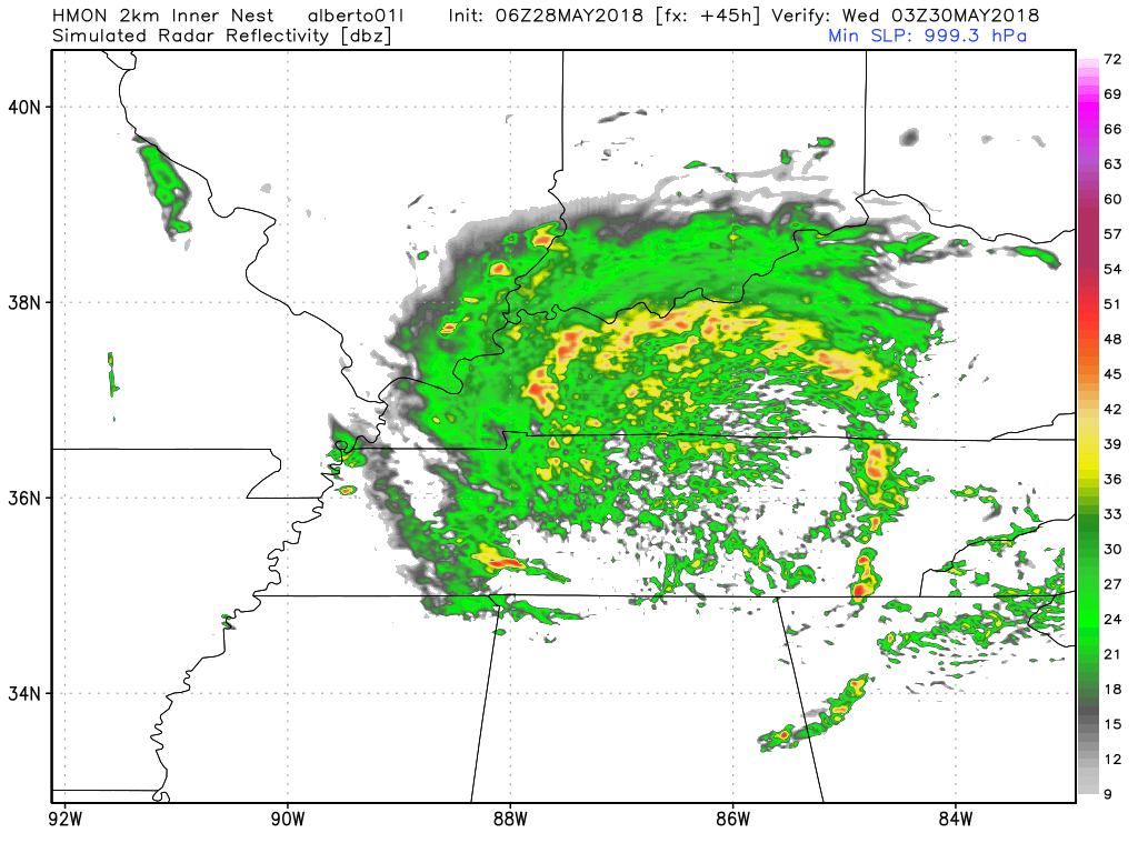
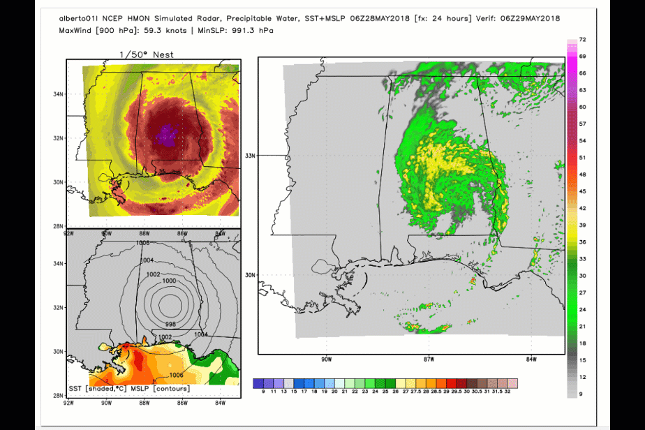
Notice on the future-cast radar how Alberto is skewed to the east vs west.
Some of our counties will receive no rain from this event. Other areas will receive over three inches.
.
.
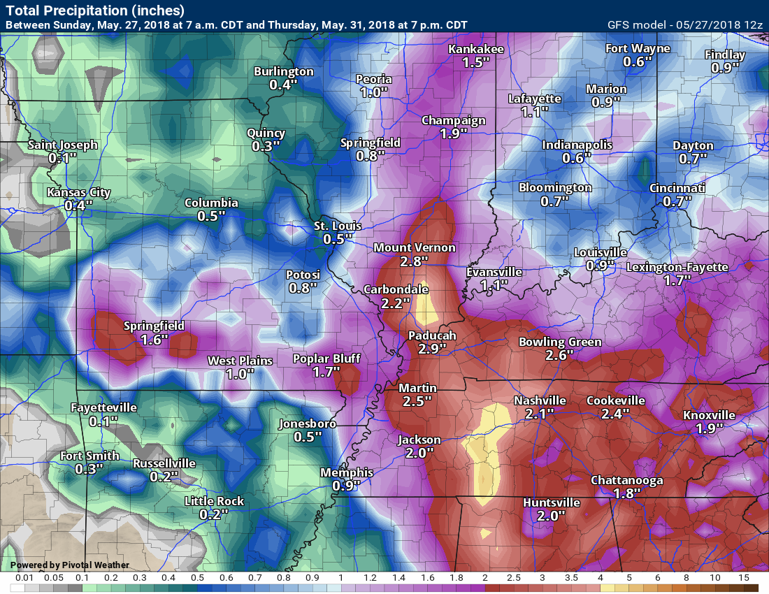
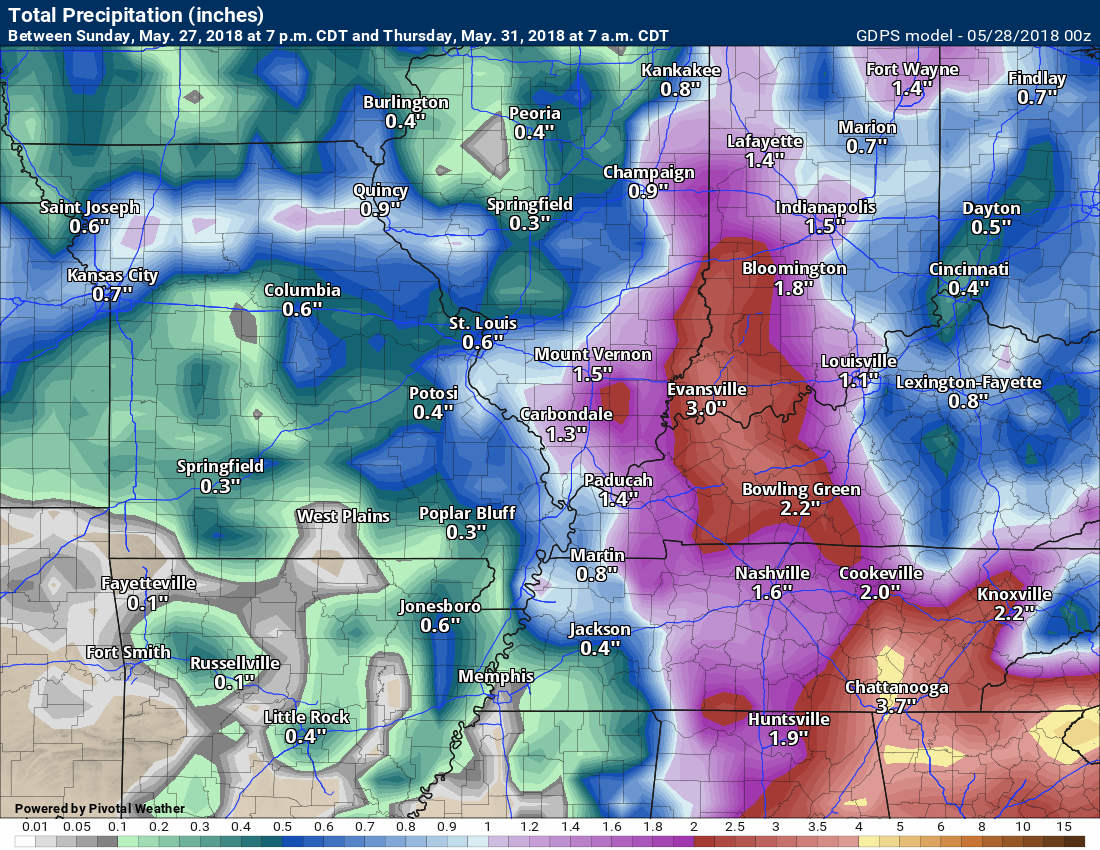
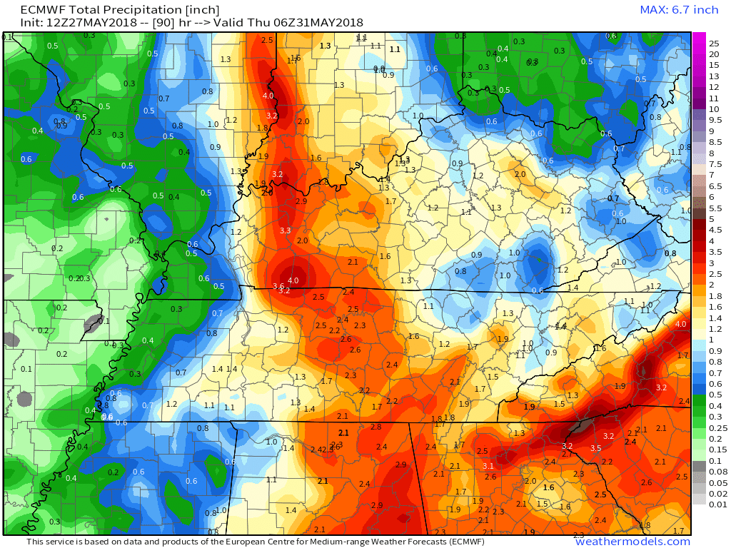
RAIN TOTALS
It is important to remember, late spring and summer thunderstorms can drop a lot of rain in a short amount of time. Rain rates can occasionally exceed 1.5 to 2″ per hour. This can cause brief periods of flash flooding or ponding of water.
It is next to impossible to forecast which county will receive more rain than a neighboring county. Typical, for our region. Your neighbor can pick up a heavy thunderstorm and you end up with just a few drops.
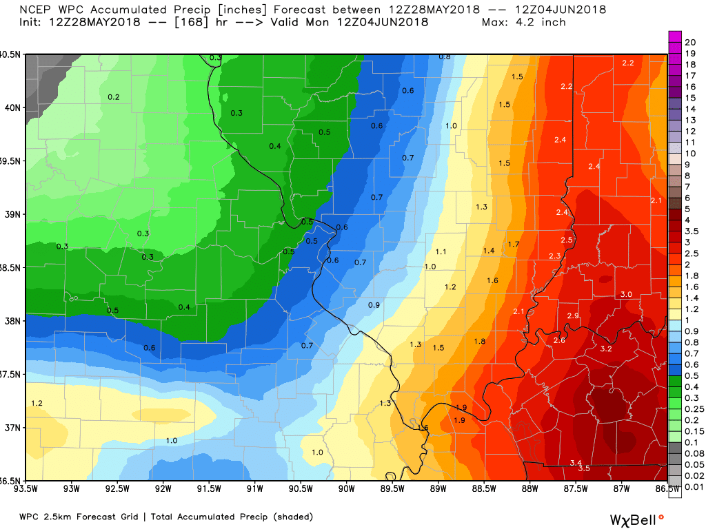
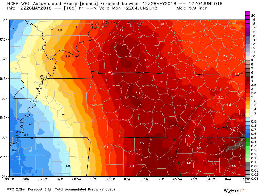
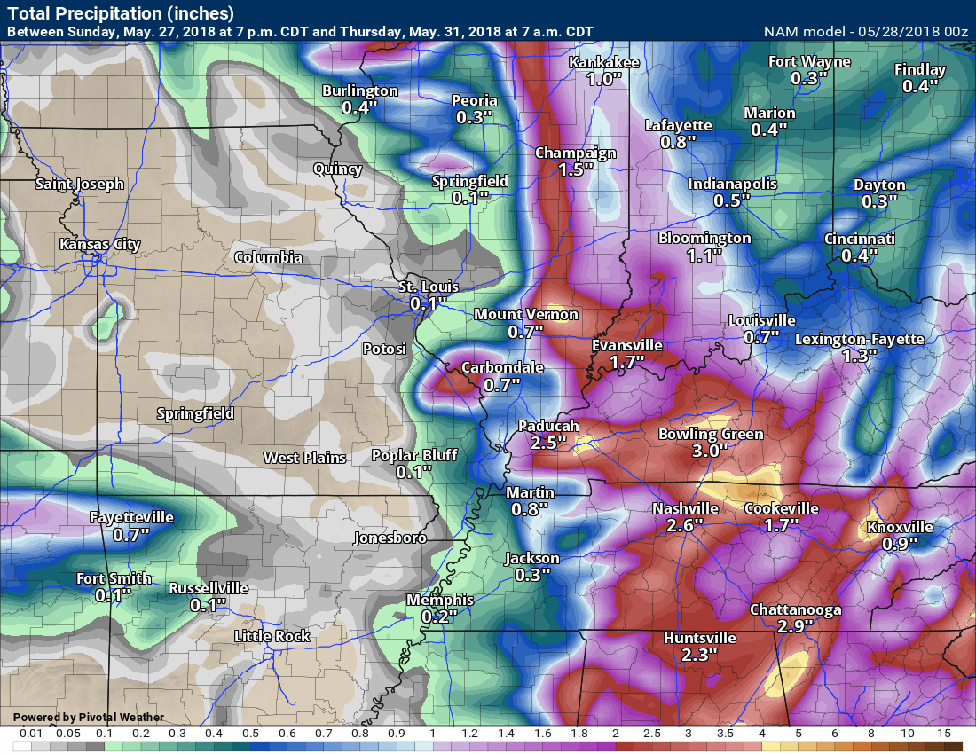
Let’s look at four models. These are showing you rain totals through Wednesday.
The bulk of this rain will fall with Alberto.
Notice the eastern half of the region is forecast to receive more rain than the western half. That is because the path of Alberto should be across our eastern counties. Monitor updates.
WPC rainfall forecast (NOAA)
Zoomed in on IL/MO and then KY/TN zoom (click to enlarge)
.
.
NAM model
GFS model
GEM model
EC model

Interactive Radars:
Interactive live weather radar page. Choose the city nearest your location. If one of the city radars won’t load then try a nearby one. Click here.

Questions? Broken links? Other?
You may email me at beaudodson@usawx.com

The National Weather Service defines a severe thunderstorm as one that produces quarter size hail or larger, 58 mph winds or greater, and/or a tornado.
Monday through Wednesday: Locally heavy thunderstorms are again possible. PWAT values will be high. That means heavy rain. Some areas could experience brief flash flooding. I can’t rule out isolated down-burst winds. These winds can be isolated and likely won’t receive a severe thunderstorm warning. Keep this in mind over the coming weeks.
![]()
Interactive live weather radar page. Choose the city nearest your location. If one of the cities does not work then try a nearby one. Click here.
National map of weather watches and warnings. Click here.
Storm Prediction Center. Click here.
Weather Prediction Center. Click here.

Live lightning data: Click here.

Interactive GOES R satellite. Track clouds. Click here.

Here are the latest local river stage forecast numbers Click Here.
Here are the latest lake stage forecast numbers for Kentucky Lake and Lake Barkley Click Here.

The spring and preliminary summer outlooks have been posted for subscribers. Scroll down to see the outlook.
Not a subscriber? Learn more at this link.

Weather Headlines.
- A warm and humid week ahead
- Here comes Alberto
- Eastern half of region will receive more rain than the western portion
Storm tracking links below.
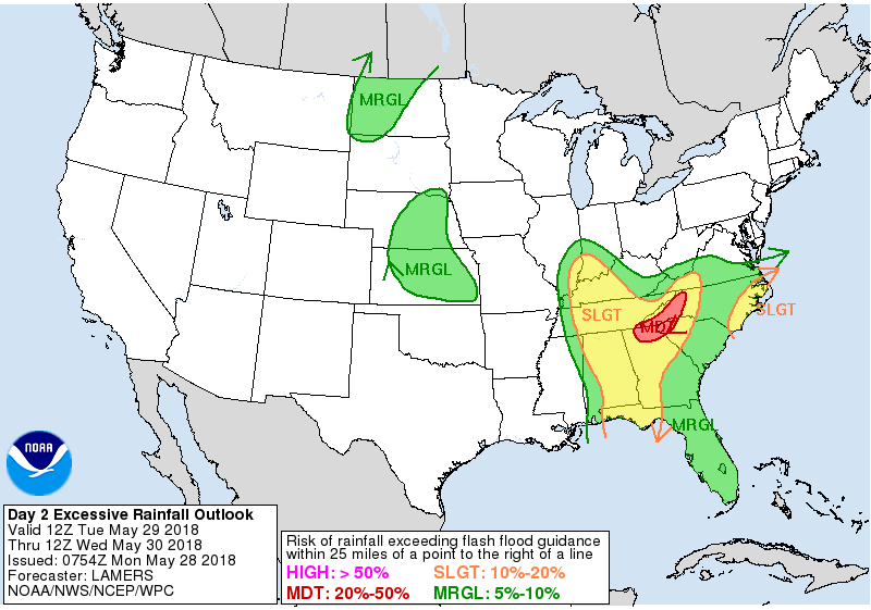
We do have a risk of flash flooding, especially Tuesday into Tuesday night. We have been placed under a marginal to slight risk of flash flooding during this time period.
.
.
The Tropics
Alberto
The remnants of Alberto will approach the region Monday into Wednesday. This will bring some heavy rain to portions of the area. The exact track will need to be monitored.
Here is the official National Hurricane Center track forecast of Alberto.
The cone is the possible path. Don’t zero in on the center of the cone.
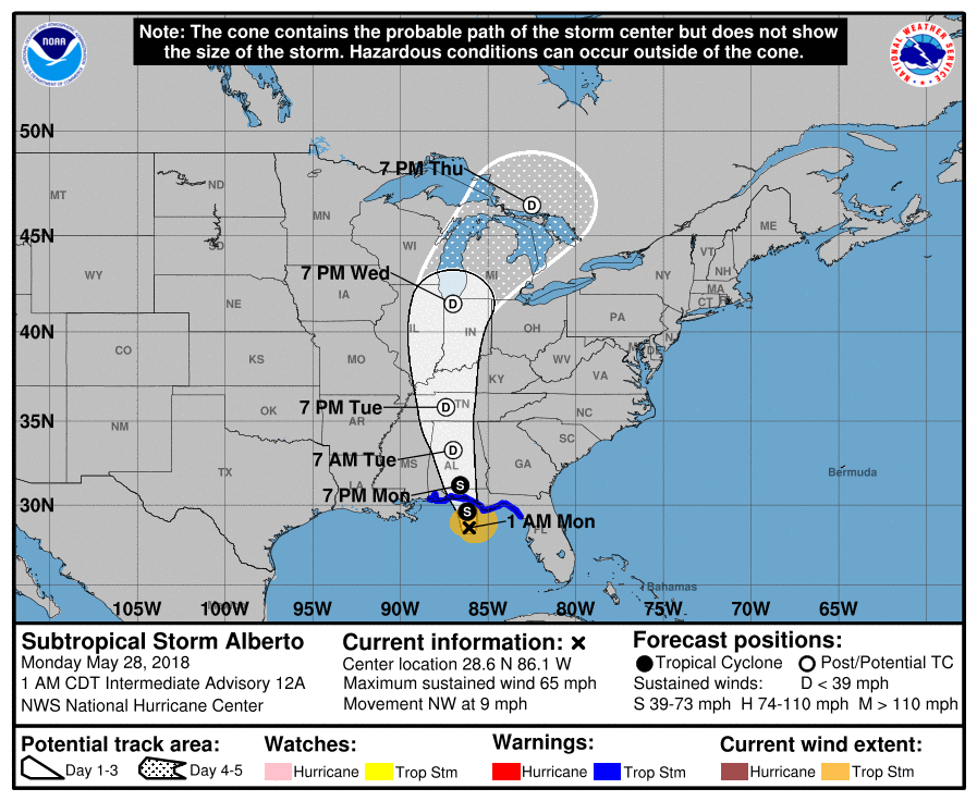
At this time, it appears our eastern counties will receive the heaviest rain totals. Any shift in the systems track will change the forecast numbers, keep this in mind.
Notice that we may have a band of storms form Monday afternoon (well ahead of the system).
Time-stamp upper left
.
.
Here is the NAM future-cast radar. This is one models opinion on the eventual track of the remnants of Alberto.
.
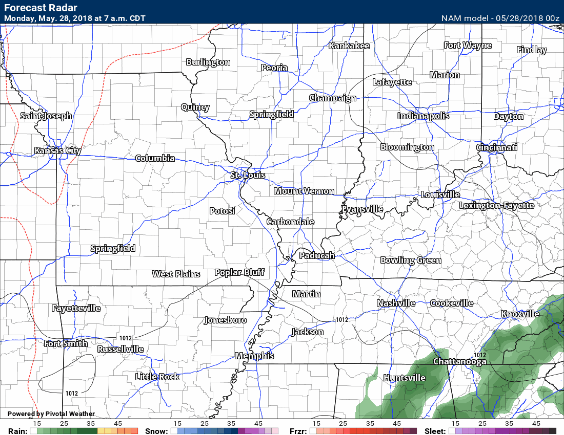
.
Here is the SPC WRF model guidance future-cast radar. This takes us into this evening.
.
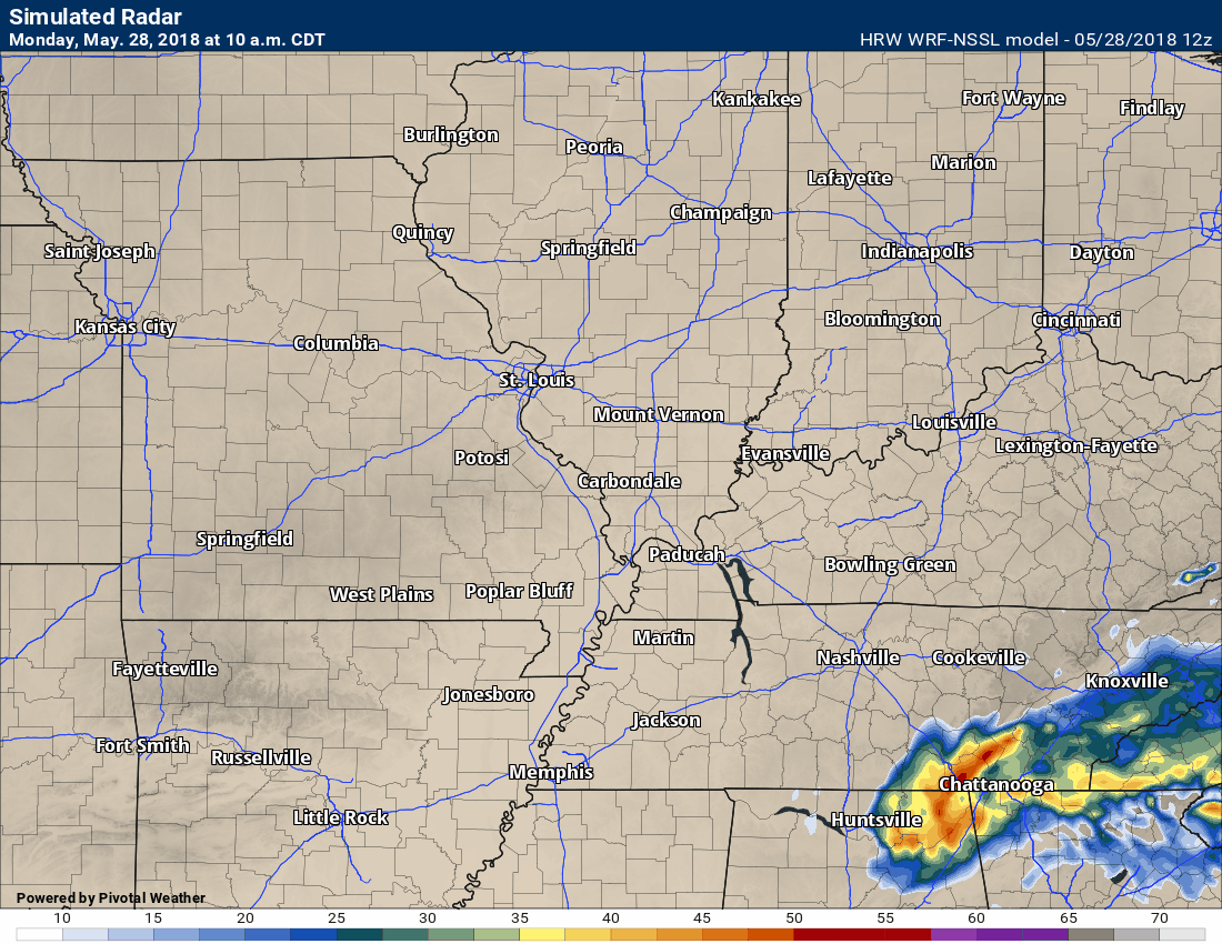
.
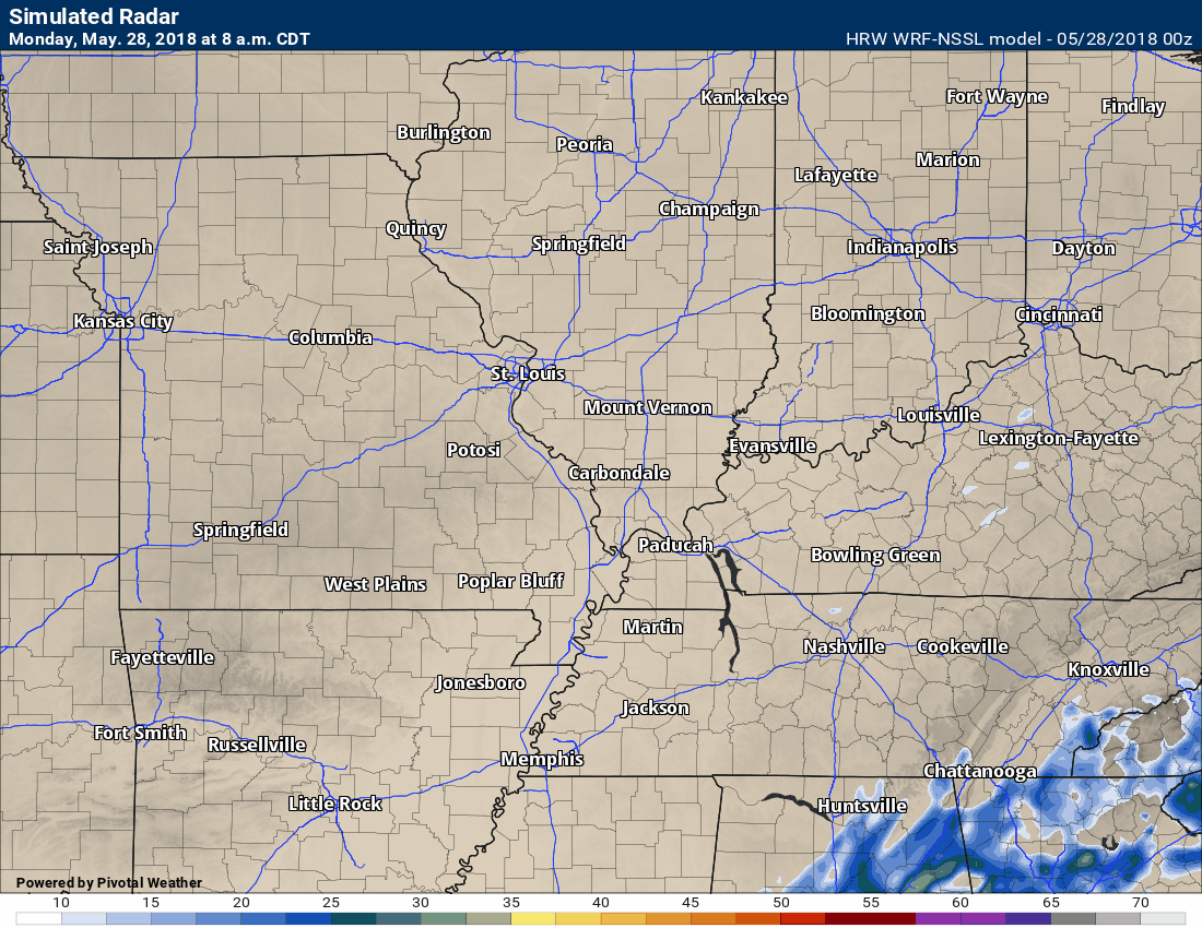
Here is another model. This is a high resolution model used for tropical systems.
.

A new weather podcast is now available! Weather Geeks (which you might remember is on The Weather Channel each Sunday)
To learn more visit their website. Click here.
![]()

WeatherBrains Episode 643
Tonight’s Guest WeatherBrain is a Research Meteorologist at National Severe Storms Laboratory and a visiting Professor of Atmospheric Science at Desert Research Institute and the University of Nevada-Reno. He is the author of the recent AMS Book: Verner Soumi: The Life and Work of the Founder of Satellite Meteorology. He joins us tonight from his daughter’s home in Sacramento. Please welcome Dr. John Lewis to WeatherBrains.
Throughout his career, Dr. Lewis has conducted research that has combined weather analysis with numerical weather prediction. His professional experience has been divided between work in government labs including operational prediction centers and academia. In the past decade, he has led a national research project focused on the weather over the Gulf of Mexico, Project GUFMEX, explored the use of adjoint methods to study model sensitivity, and contributed to the history of science. In 1998, the Environmental Research Laboratories of NOAA assigned Dr. Lewis to Desert Research Institute on a long-term duty assignment. This assignment was made in connection with a 5-year plan to improve weather forecasting in the Western United States. Central to this effort is the use of adjoint models to clarify the relative importance of the various meteorological fields used to initialize deterministic prediction models.
Other discussions in this weekly podcast include topics like:
- Extremes: 102 at Rio Grande Village, TX, and 23 at Stanley, ID, Crested Butte, CO, & Gothic, CO
- Non-tropical low off the west coast of Florida
- Severe weather Tuesday over Mid-Atlantic states
- Serious drought from AZ to West TX
- Fairly warm across the continental US
- Astronomy Outlook with Tony Rice
- and more!
Previous episodes can be viewed by clicking here.

We offer interactive local city live radars and regional radars. If a radar does not update then try another one. If a radar does not appear to be refreshing then hit Ctrl F5. You may also try restarting your browser.
The local city view radars also have clickable warnings.
During the winter months, you can track snow and ice by clicking the winterize button on the local city view interactive radars.
You may email me at beaudodson@usawx.com
Find me on Facebook!

Find me on Twitter!

Did you know that a portion of your monthly subscription helps support local charity projects?
You can learn more about those projects by visiting the Shadow Angel Foundation website and the Beau Dodson News website.

I encourae subscribers to use the app vs regular text messaging. We have found text messaging to be delayed during severe weather. The app typically will receive the messages instantly. I recommend people have three to four methods of receiving their severe weather information.
Remember, my app and text alerts are hand typed and not computer generated. You are being given personal attention during significant weather events.
